Eff ect of random phase error and baseline roll angle error on eddy identif ication by interferometric imaging altimeter*
Le GAO , Hanwei SUN , Jifeng QI , Qiufu JIANG
1 CAS Key Laboratory of Ocean Circulation and Waves, Institute of Oceanology, Chinese Academy of Sciences and Center for Ocean Mega-Science, Chinese Academy of Sciences, Qingdao 266071, China
2 Beijing Radio Measurement Institute, Beijing 100854, China
3 Pilot National Laboratory for Marine Science and Technology (Qingdao), Qingdao 266237, China
Abstract To achieve better observation for sea surface, a new generation of wide-swath interferometric altimeter satellites is proposed. Before satellite launch, it is particularly important to study the data processing methods and carry out the detailed error analysis of ocean satellites, because it is directly related to the ultimate ability of satellites to capture ocean information. For this purpose, ocean eddies are considered a specif ic case of ocean signals, and it can cause signif icant changes in sea surface elevation. It is suitable for theoretical simulation of the sea surface and systematic simulation of the altimeter. We analyzed the impacts of random error and baseline error on the sea surface and ocean signals and proposed a combined strategy of low-pass f iltering, empirical orthogonal function (EOF) decomposition, and linear f itting to remove the errors. Through this strategy, sea surface anomalies caused by errors were considerably improved, and the capability of satellite for capturing ocean information was enhanced. Notably, we found that the baseline error in sea surface height data was likely to cause inaccuracy in eddy boundary detection, as well as false eddy detection. These abnormalities could be prevented for “clean” sea surface height after the errors removal.
Keyword: interferometric altimetry; baseline error; random error; ocean eddy; theoretical and systematic simulation; error removal strategy
1 INTRODUCTION
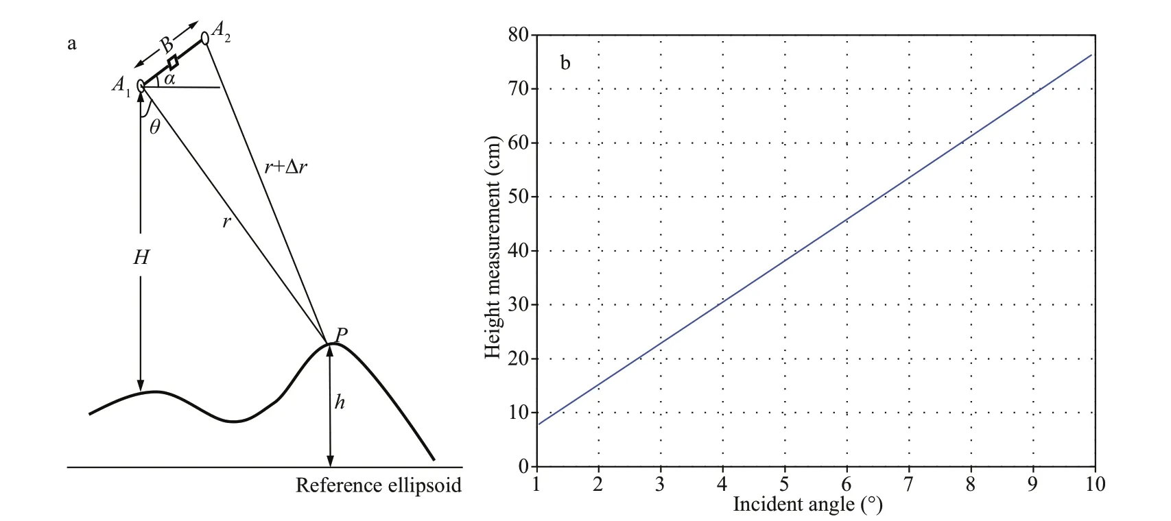
Fig.1 Schematic diagram of interferometric altimetry (Jin et al., 2014) (a); ocean surface height error induced from baseline roll angle error of 1 arcsec (b)
Oceanic eddies are important ubiquitous components of the ocean circulation system and play an essential role in the transportation and distribution of marine materials, energy, heat, and freshwater(Chelton et al., 2011; Chen et al., 2011; Nan et al.,2011; Wang et al., 2012; Sun et al., 2019). Ocean eddies can cause signif icant elevation diff erences among sea surface. According to size, oceanic eddies can be classif ied as either mesoscale or submesoscale eddies (Qiu et al., 2014; Penna and Gaube, 2019;Zhang et al., 2019). Existing high-resolution altimetry satellites have the capability to capture mesoscale oceanic eddies but not smaller eddies in the submesoscale. Therefore, better sampling (broader coverage, higher accuracy, higher spatiotemporal resolution) wide-swath interferometric imaging altimeter has been proposed, e.g., the Surface Water and Ocean Topography (SWOT) (Fu et al., 2012; Fu and Ubelmann, 2014; Xu et al., 2017) and Guanlan(Chen et al., 2019) satellite missions, which plan to launch in 2021 and 2022, respectively. The presence of instrument noise will aff ect the accuracy of ocean information extraction; therefore, the error analysis of the swath-wide interferometric altimeter plays an essential role before the launch. NASA SWOT workshop proposed an error analysis method based on wavenumber spectrum analysis (Fu et al., 2012; Fu and Ubelmann, 2014), and developed the SWOT Simulator software to directly evaluate the observation error from the perspective of wavenumber spectrum(Gaultier et al., 2016; Qiu et al., 2016). However,there is no complete simulation process of sea surface scattering modeling, radar altimeter echo modeling,imaging processing, and interference processing in the software. To facilitate data processing after the launch of the interferometric altimeter satellite, we shall analyze the ocean errors from the perspective of complete data processing. In this study, we carried out sea surface height extraction and a baseline and random error analysis based on theoretical and systematic simulation of interferometric altimetry.Further, we analyzed the inf luence of the error on the eddy extraction precision. Due to the limitation of the analysis depth of a single error source and article length, this article only discusses the random errors and baseline errors than other error sources, although they are equally important.
2 INTERFEROMETRIC ALTIMETRY PRINCIPLE
Based on the Interferometric Synthetic Aperture Radar (In-SAR) technique (shown as Fig.1a), an interferometric altimeter can obtain an observation swath extending tens to hundreds of kilometers with a small incidence angle (usually within 10°) near nadir.The angle measurement error of the baseline roll angle can cause signif icant errors in the height measurement of the sea surface elevation. Derived from the interferometric principle, the relationship between the baseline roll angle measurement error and the interferometric height error is (Jin et al., 2014;Kong et al., 2017):

where,θis the incidence angle,ris the distance between antenna phase center and the sea surface, is the angle measurement error of the baseline roll angle,Δαis the angle measurement error of the baseline roll angle.
Figure 1b shows the elevation error caused by the baseline roll angle error increases with the increase of the incidence angle in the cross-track direction. The baseline error of 1 arcsec results in an average height measurement error of 45 cm in the swath, but it can even reach ~80 cm in the distal swath (incidence angle of 10°). The elevation error caused by the baseline roll angle error can be simply recorded as the baseline error.
The random error is the height error caused by the interferometric phase error, and the inf luencing factors include signal-to-noise ratio (SNR)decorrelation, geometric decorrelation, and angular decorrelation, etc. In this study, ocean signal decoherence is mainly caused by primary and auxiliary SAR imaging error or their registration error. The random error is also related to the incidence angle shown as Eq.2 (Kong et al., 2017).

where,kis radar wave number,σphaseis interferometric phase error,Bis baseline length,θis the incidence angle.
The random height error induced from the interferometric phase error is shown in Fig.2. The error is small in the middle and large on both sides of the edge in the interferometric swath, and the rootmean-square error (RMSE) is 0.85 cm at the gird of 3 km×3 km.
3 METHOD
Our method consists of two parts, theoretical simulation and systematic simulation (Fig.3). The goal of the theoretical simulation is to obtain an arbitrary ideal sea surface with the eddy signals or signif icant elevation diff erence. This ideal sea surface can be obtained using a numerical ocean model. Here,we took Regional Ocean Modeling System (ROMS)(Shchepetkin and McWilliams, 2005) sea surface model data as the ideal ocean surface height. The system simulation is the whole process simulation from altimeter observation to data processing, and the simulation process is consistent with the altimeter remote sensing observation and data processing. In this study, the goal of the systematic simulation is to extract the elevation from the ideal sea surface of theoretical simulation and analyze the eddy signal based on the designed parameters of the interferometric altimetry system. The systematic simulation process mainly includes sea surface scattering modeling(Vandemark et al., 2016), radar altimeter echo modeling (Zeng et al., 2010), primary and auxiliary SAR imaging processing (e.g., Range-Doppler algorithm in Cumming and Wong (2005)), and interference processing (Kong et al., 2017). We obtain the baseline error according to the altimeter principle in Eq.1 and add it to the modeling echo in the radar altimeter. Besides, the random phase error is also induced in the interference processing because of the SAR imaging inaccuracy and the registration error of the primary and secondary SAR images. The systematic simulation accuracy of the altimetry system will be analyzed by considering the inf luence of the random and baseline errors. Finally, the ocean eddies are extracted (Isern-Fontanet et al., 2003; Liu et al., 2016) from theoretical and systematic ocean surfaces and make a comparison in detail.
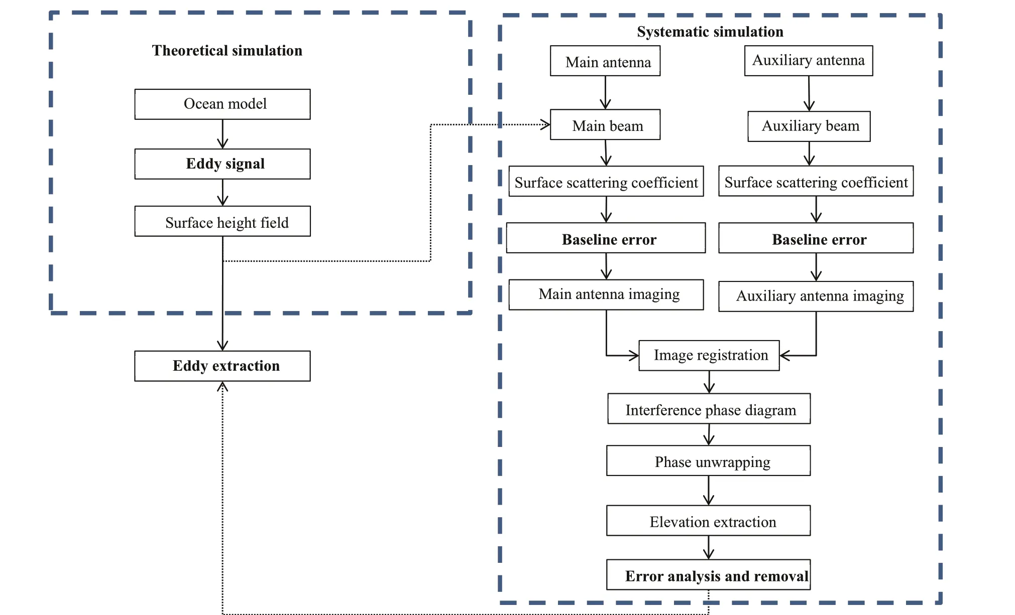
Fig.3 Flow chart of theoretical and systematic simulation of interferometric system
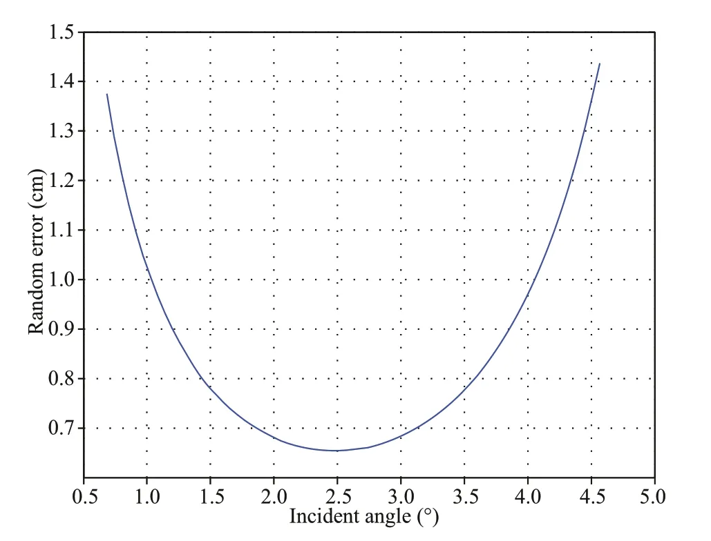
Fig.2 Ocean surface height error induced from the random interferometric phase error
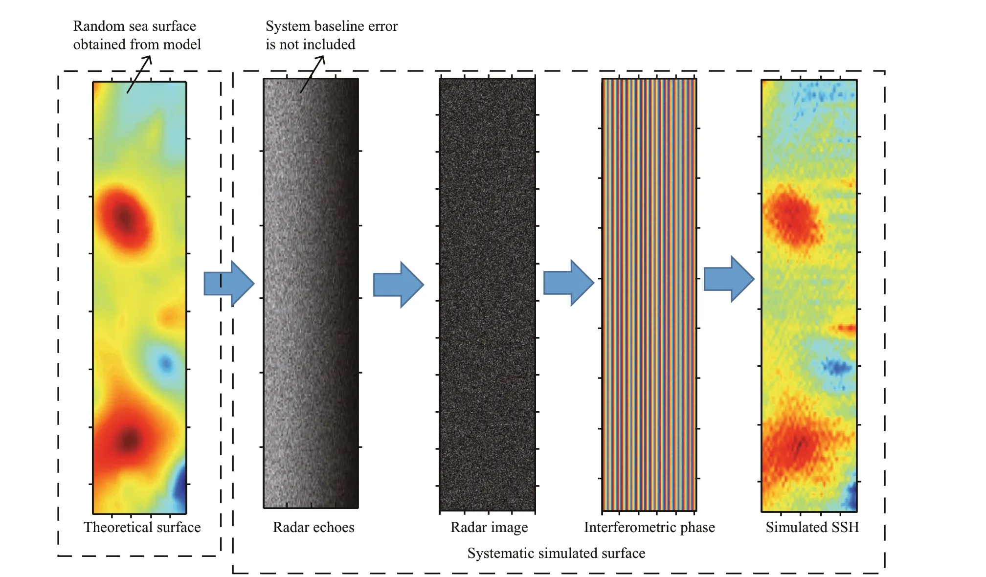
Fig.4 Random phase error analyses in data processing of altimeter system
To analyze the eff ect of baseline error on ocean signal, a combined-strategy of low-pass f iltering,empirical orthogonal function (EOF) decomposition,and linear f itting, is proposed for error removal of the f inally systematic sea surface. The strategy is as follows: compared with the sea elevation signal, the random noise is a type of high-frequency signal.Therefore, as far as possible, useful ocean signals can be retained through low-pass f iltering. Then, the single sea surface height (SSH) image is divided into several sub-images in along-track direction to form a sub-image sequence. Then, EOF analysis is applied to the sequence to extract the signal mode. The f irst few valid modal components can be selected using EOF decomposition and modal signal validity analysis (Li et al., 2000; Wenzel and Schröter, 2014). From the retained modal signal, the baseline error can be estimated by linear f itting in the cross-track direction,because of the characteristic of the approximate linear increase of the baseline error. Then, the estimated baseline error can be removed from the retained EOF signal to obtain a “clean” sea surface elevation. The“clean” sea surface elevation can be compared with the originally theoretical simulated surface.
4 RESULT AND DISCUSSION
Through three scenarios, we analyzed the eff ects of the altimeter system’s baseline error and random error in data processing for the ocean surface obtained from the theoretical simulation and systematic simulation,and ocean surface signal extraction accuracy. The designed parameters of the interferometric altimetry system are shown in Table 1.
Scenario 1: Altimeter system does not contain baseline error, only random error is considered because of imaging error or registration error of primary and secondary images.
Figure 4 shows the intermediate result of the theoretical and systematic simulation of the altimeter system. It can be seen that the random error only makes the sea surface obtained from the systematic simulation rough compared with the theoretical simulation.However, the ocean eddy signal is still clear and distinct.
Scenario 2: Altimeter system contains baseline error, and the random error in data processing is also taken into account at the same time.
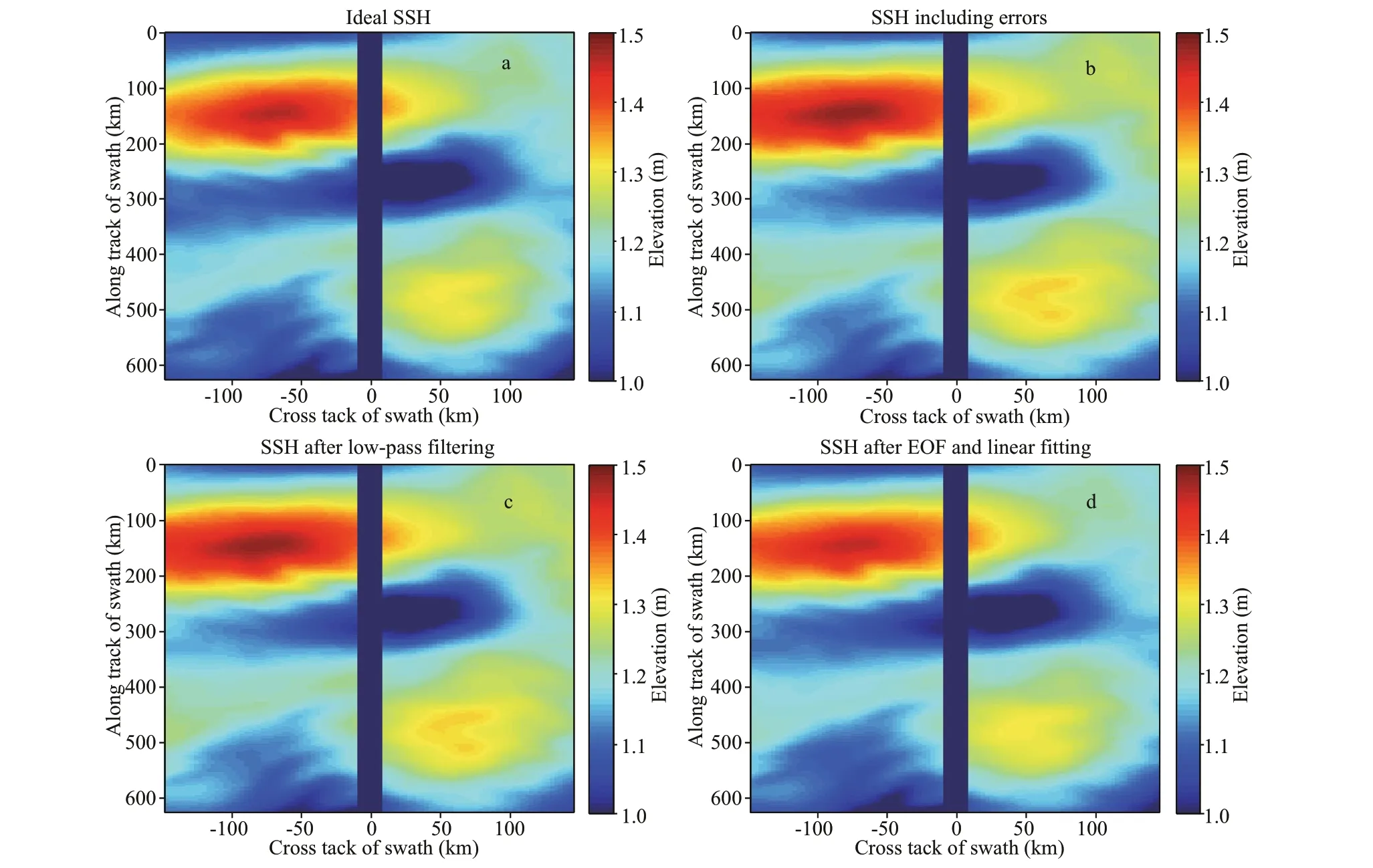
Fig.5 Theoretically simulated the sea surface from ocean model (a); systematic simulated sea surface (b); sea surfaces after error removal from (b) using a combined-strategy of low-pass f iltering (c), EOF decomposition, and linear f itting (d),individually
Figure 5 shows the theoretical simulated surface(Fig.5a), systematic simulated surface (Fig.5b), and the surface after error removal from Fig.5b using the proposed combined-strategy (Fig.5c & d). To estimate the error in the sea surface obtained from the systematic simulation and evaluate the error removal eff ect of the combined-strategy, we subtracted Fig.5b-d from Fig.5a to get the sea surface error and the residual error (Fig.6). Figure 6a shows that the error distribution pattern is consistent with that interferometric principle in Section 2; therefore, the baseline error is the main error source in the sea surface obtained from the systematic simulation.However, it can be seen that Fig.6b is almost the same as Fig.6a, and it shows the eff ect of random error removal using low-pass f iltering is relatively weak because of the low proportion of simulated highfrequency noise. Table 2 also conf irms the poorremove eff ect, and residual error decreased by only 0.2 (0.1) cm on average (RMSE). However, the proposed EOF and linear f itting combined-strategy have a noticeable eff ect for baseline error elimination shown in Fig.6c. Table 2 shows the f inal residual error decreases from 2.7 (3.1) cm to 0.1 (1.0) cm on average(RMSE), and the residual error is mainly distributed at image edges in the swath. And, more remarkable,the f inal residual error conforms to the distribution characteristics of random error in Fig.2, and the residual error in the margin in the swath is signif icant,the middle is small. It indicates that the random error is the noise f loor in the systematic processing, and it cannot be eliminated by a particularly eff ective method at present. However, the low-pass f iltering method was tried in this study and played a weak error removal eff ect, and other methods need to be further considered.
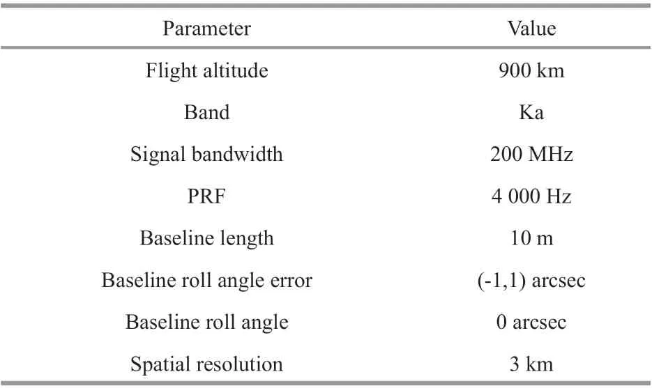
Table 1 Numerical simulation parameters of interferometric altimetry

Table 2 Statistics of baseline error and residual error after the error removal
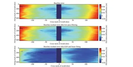
Fig.6 System error obtained by Fig.5b minus Fig.5a (a); residual error by Fig.5c minus Fig.5a (b); f inal residual error by Fig.5d minus Fig.5a (c)
Scenario 3: Eddy extraction and analysis based on Scenario 2
Ocean eddies can be extracted by various methods(Isern-Fontanet et al., 2003; Mason et al., 2014; Liu et al., 2016). We extracted ocean eddies from the theoretical simulated surface, the systematic simulated surface, and the surface after error removal in Fig.5,separately. In the theoretical simulated surface, Eddy 1 and Eddy 2 were detected (Fig.7a). A dark blue area of low sea surface height can be seen separating the two eddies. In Fig.7b, the existence of the baseline error slightly enlarges the boundary of Eddy 1. In contrast, it dramatically reduces the boundary of Eddy 2, mainly because of the reduced area of low sea surface height values between the two eddies in the right swath. Figure 7c shows that the eff ect of error removal using low-pass f iltering is weak, i.e., the detected eddies are almost the same as Fig.7b. Figure 7d shows that the height characteristics of the theoretical simulated surface are entirely restored,and the range of the area of low sea surface height is also restored; consequently, the extracted eddies are almost identical to those of the ideal sea surface shown in Fig.7a. The sea surface height after baseline error removal through the proposed combinedstrategy is perfect.
5 CONCLUSION
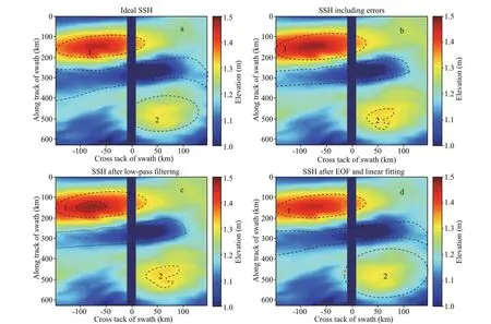
Fig.7 Ocean eddy extraction based on ocean surface height of scenario 2
A new generation of altimetry satellites provides the possibility for better observation of the sea surface,especially for the submesoscale ocean signals. Before satellite launch, data processing and the related error analysis based on interferometric altimetry are particularly important, and they directly aff ect the satellite’s ability to capture ocean signals. Because ocean eddies can cause signif icant elevation diff erences on the sea surface, this is very convenient for the theoretical simulation and systematic simulation for wide-swath interferometric altimetry.Therefore, in this study, the sea surface height extraction, sea surface error analysis, and ocean signal extraction are realized using the theoretical simulation and the systematic simulation. In particular, by analysis of three scenarios of the random error in data processing, baseline error in the altimetry system, and sea surface eddy extraction, the proposed combinedstrategy of low-pass f iltering, EOF decomposition,and linear f itting achieves a superior eff ect in systematic baseline error removal, thus signif icantly improving the ability of satellite altimetry to capture ocean signal. Through simulation experiments, the f inal error decreases from 2.7 (3.1) cm to 0.1 (1.0) cm on average (RMSE). The residual errors have the same distribution characteristics as random errors,and it is proved the noise f loor in the altimeter data processing. It has also been proved that, after error removal, the sea surface can be recovered, and the ocean eddies are accurately extracted.
6 DATA AVAILABILITY STATEMENT
The theoretical sea surface can be simulated by ROMS model or other ocean models. NASA SWOT workshop use ROMS model data for error analysis and developed a SWOT error simulator. A large number of ideal sea surfaces were provided in its doc folder in SWOT error simulator at the website:https://github.com/SWOTsimulator/swotsimulator/tree/master/doc/images.
 Journal of Oceanology and Limnology2022年5期
- Journal of Oceanology and Limnology的其它文章
- Comparison of three f locculants for heavy cyanobacterial bloom mitigation and subsequent environmental impact*
- Eff ect of light intensity on bound EPS characteristics of two Microcystis morphospecies: the role of bEPS in the proliferation of Microcystis*
- Community structure of aerobic anoxygenic phototrophic bacteria in algae- and macrophyte-dominated areas in Taihu Lake, China*
- Tidal water exchanges can shape the phytoplankton community structure and reduce the risk of harmful cyanobacterial blooms in a semi-closed lake*
- Estimating the evolution of sea state non-Gaussianity based on a phase-resolving model*
- Sodium acetate can promote the growth and astaxanthin accumulation in the unicellular green alga Haematococcus pluvialis as revealed by a proteomics approach*
