云物理与人工影响天气研究进展
2013-07-05 16:44
中国气象科学研究院年报 2013年0期
大气物理与人工影响天气
Atmospheric Physics and Weather Modifcation
云物理与人工影响天气研究进展
1 云物理观测研究
1.1 TRMM卫星反演的南海中尺度对流系统的云结构与数值模式比较研究
研究了TRMM卫星的降水雷达(PR)及微波成像仪(TMI)观测的南海中尺度对流云结构及演变与中尺度可分辨云数值模式模拟结果,并探讨了对流有效位能(CAPE)及风切变的影响作用。研究结果表明,TRMM卫星的PR和TMI可以较好地探测南海中尺度对流云系统的主要特征,但是PR反演的5月地面降水低于6月,而TMI的反演结果相反。TRMM卫星反演的降水量与通过探空和模式得到的降水量基本一致,但是探空和PR估测的降水高于TMI估测值。WRF模式对最大降水率的模拟低于PR估测降水约22%,低于TMI估测值10.4%,低于探空估测降水12.5%。WRF和GCM模式对暖云微物理过程的模拟与TMI比较一致,但模式模拟的冰水含量相对TMI偏小。(郭学良等)
1.2 一次积层混合云系人工增雨作业的综合观测分析
利用2009年4月18日一次积层混合云飞机云物理观测和播云试验资料,结合卫星、雷达、加密探空和雨量等观测资料,对该次积层混合云系人工增雨作业条件、作业效果和云降水变化进行了综合分析。结果表明:此次降水云系为积层混合云,云中过冷水丰沛,具有很好的可播性,强可播区占作业云体的主要部分;云的可播性与雷达回波有一定的对应关系,C波段雷达回波的强弱与降水粒子谱有较好的相关性,与云滴谱相关性相对较弱;播云作业过后,云中小云粒子浓度减少,大云粒子和降水粒子浓度增加,雷达回波的相应位置出现亮带。提出了利用作业影响区和对比区的区域雨量变化率来分析作业效果的方法。此次过程的计算结果表明,作业后3~4h内降水增加,雨量增幅为120%~180%。(周毓荃,蔡兆鑫,蔡淼)
1.3 云的垂直非均一性对卫星3.7 μm通道反射率的影响
卫星3.7 μm通道被广泛用于反演云粒子有效半径。为了解云的垂直非均一性对该通道反射率的影响,基于SBDART辐射传输模式,分别计算了有效粒子半径垂直连续变化分布下和垂直分层均一分布下的3.7 μm通道反射率。对于有效粒子半径垂直连续变化分布的云,当云比较薄(光学厚度<10)时,如果把有效粒子半径垂直非均一的云当作垂直均一的云进行反演,会出现一定的误差,该误差随着光学厚度的增大而减小。当云足够厚(光学厚度>10)时,该误差<10%,可以认为此处云粒子垂直结构的变化对3.7 μm通道反射率没有影响。对于有效粒子半径垂直分层均一分布的云,当光学厚度比较大时,只有靠近云顶的“浅层”(即有效辐射层,其光学厚度为3~10)的云参数变化才能对3.7 μm通道反射率产生影响。有效辐射层的光学厚度与云上层有效粒子半径、太阳天顶角和卫星天顶角等因素呈反相关,与相对方位角无明显的联系。(周毓荃,刘浩)
1.4 L波段探空判别云区方法的研究
利用2008年1月至2009年12月的L波段探空资料和与之时空匹配的CloudSat云观测资料,分析了云内和云外相对湿度的累积频率分布,发现以75%作为相对湿度阈值判断云准确率可达81%。利用BS和TS评分方法,对不同相对湿度阈值进行评分分析,发现以81%作为相对湿度阈值该TS评分可达0.66,为最高。利用BS和TS评分方法分不同高度对相对湿度阈值进行评分分析,发现随高度的增加,具有最好TS评分的相对湿度阈值减小。利用这些阈值对云进行判断时,总的TS评分高于0.6,并且其准确率达到84%以上,比利用单一相对湿度阈值判断云准确率要高。对这些阈值进行优化,得到一套适合我国L波段探空秒数据的云直垂结构的判别方法。(蔡淼,周毓荃,欧建军)
2 云降水物理与人工影响天气数值模拟研究
2.1 地形动力抬升和重力波传播与地形云和降水形成关系研究
地形云和降水在区域水循环、水资源、生态环境及气候变化中具有十分重要的作用。利用中尺度数值模式WRF 数值模拟试验,通过引入表示大气层流速度、层结稳定度和地形特征的关系参数——湿Froude 数(Fw),研究了北京2009 年5 月1 日湿条件不稳定大气层结下,地形云和降水形成过程与地形动力抬升和地形重力波传播之间的关系及形成机理。研究表明,在地形最大高度2 km、半宽10 km的条件下,层流速度从2.5 m/s 逐步增加到25 m/s 时,对应的Fw 从0.19 增加到1.81。当Fw≤1 时,地形的阻挡起主要作用,由地形抬升形成的地形云主要产生在迎风坡一侧。地形重力波主要产生在迎风坡,并向上游传播,先形成层状云,最后演变为准稳定浅对流波状云,最大降水主要发生在紧靠山顶的迎风坡一侧,但当Fw 很小时,地形云不产生降水。当Fw>1 时,地形抬升形成的云主要发生在山顶附近,而地形重力波主要形成在背风坡,并向下游方向传播,形成准稳定波状云,最大降水主要产生在紧靠山顶的背风坡一侧。另外,在弱湿条件不稳定大气层流下,地形降水主要由地形动力抬升造成的暖云微物理过程产生,地形重力波形成的波状云几乎不产生降水。(郭学良等)
2.2 基于雷达资料的云分析在冰雹云短时预报中的应用
通过ARPS/ADAS云分析系统将雷达反射率因子信息引入到模式的初始场中,并结合中尺度数值模式模拟研究了2008年6月23日发生在北京周边地区的一次冰雹天气过程。结果表明:在初始场中引入雷达反射率信息之后,明显改进了初始场中水汽信息和温度场,使得初始场更加符合实际大气状况;与未进行云分析试验比较,云分析之后,模式模拟对雹云产生位置、强度以及移动路径有明显改进,其中3 h之内的模拟效果最好;降水降雹提早1 h发生,并且降水降雹的峰值也提前出现,在初始场中引入雷达资料,明显减少模式spin-up时间。(郭学良等)
2.3 AgI催化减弱强对流云降水的微物理过程分析
利用耦合了AgI催化模块的三维对流云模式,对一次强对流云降水过程的AgI催化减雨数值试验的微物理过程进行了分析。分析发现催化后霰含量和冰晶含量大幅增加,同时过冷云水则由于冰晶的大量核化而被消耗。催化后过冷雨水也出现了大幅减少。过冷雨水主要被冰晶碰冻成霰,少量雨水则直接被霰粒子碰并,同时极少量雨水直接冻结成霰粒子。雨水的主要源汇项分别是霰的融化过程和雨水蒸发过程。在催化时段,霰融化成雨水量减少,导致雨量的减少。在催化停止后催化云中霰融化比自然云中多的情况下,催化云中存在大量小雨滴,雨滴尺度很小,导致雨水大量蒸发,从而使降落到地面的雨量减少。(楼小凤)
2.4 南方不同类型冰冻天气的大气层结和云物理特征研究
利用观测资料和CAMS中尺度云分辨模式,对南方3次不同类型冻雨天气过程进行模拟,重点研究了冰冻天气中冻雨区云系宏、微观结构及大气层结特征,初步分析了冻雨形成的云物理机制。结果表明:(1)逆温层的存在是冻雨发生的必要条件,低层湿度较大的逆温常与冻雨天气有关。3次冻雨过程的冻雨区都存在逆温层,其中第1、2次过程属于锋面逆温,而第3次过程属于平流逆温。可见,逆温层结有利于冻雨的发生,但逆温层的存在仅是形成冻雨的条件之一。冻雨的发生还与水汽(湿度)、风向风速、地面特征有关。低层有水汽输入到冻雨区、地面温度≤0℃,有利于冻雨形成和过冷雨水的冻结。(2)冻雨的形成需要满足3个主要条件:在对流层中高层存在冻结层,冻结层下要有暖层和逆温层,近地层有一个温度<0℃的冷却层,并且低层的冷却层相对湿度较高。中高层冻结层主要产生冰相降水粒子,中层的暖层可以确保上层降落下来的固态降水粒子(雪或霰)融化成雨滴或在融化层中直接产生液态降水。这样,雨滴下降到低空冷却层后会逐渐变成过冷雨滴,当过冷却雨滴接触到温度<0℃的地面或者其他物体表面时,迅速冻结形成冻雨。(3)不同冻雨区上空存在2种不同类型的云,对应云中有2种明显不同的温度层结,即混合相云中的“冷-暖-冷”层结和水云中的“暖-冷”层结。具有2种不同层结特征的不同冻雨区云系,对应2种不同的微物理结构,具有2种不同的冻雨形成的云物理机制。(4)同一类型天气系统中的冻雨区,可以存在不同的温度层结、云的微物理结构和冻雨形成的机制;不同类型天气系统也可以存在特征相同的冻雨区,即冻雨形成的温度层结、云的微物理结构和冻雨形成的物理机制都相同。(陶玥,李宏宇,刘卫国)
2.5 GRAPES全球模式次网格对流过程对云预报的影响研究
50 km分辨率下的GRAPES全球模式对赤道及低纬地区云水、云冰、云量和格点降水的预报较实际观测偏少。为解决这一问题,本研究在模式原有的格点尺度云方案基础上,将次网格对流过程的影响作为源汇项,加入到云水、云冰和总云量的预报方程中。结合CERES和TRMM等卫星云观测资料,进行了改进后的云方案与原云方案预报结果的对比分析。结果显示,考虑了对流对格点尺度云含水量和云量预报的影响后,GRAPES全球模式预报的云和格点降水在赤道及低纬地区有明显改善,水凝物含水量和总云量的预报结果与实况较为接近,格点降水在总降水中的比例由原来的5%提高到25%。研究表明,次网格对流过程对格点尺度云和降水的影响取决于上升气流质量通量的分布和强度,上升气流的质量通量在对流活动强烈的低纬热带地区较强,其最大值出现在450~650 hPa高度范围,因此次网格对流的卷出过程对中云的影响最为明显,对高云和低云也有一定程度的影响,使得云顶变高,云底变低。(谭超,刘奇俊,马占山)
3 人工影响天气工程建设及业务工作进展
3.1 东北人工影响天气工程建设
2013年是“东北区域人工影响天气能力建设”项目的第2个建设年度。本年度重点完成了初步设计的概算核定,推进了2架新舟60飞机的建设,完成了第3架高性能飞机的选型、机载探测设备及改装方案及单一来源采购论证,完成了高性能飞机空地通信子系统方案的设计及论证,开展了79部GPS/ MET设备、2部X波段移动多普勒天气雷达、1部C波段移动多普勒天气雷达、1套全自动国产GPS探空系统、人工影响天气作业指挥应用系统软件、106套6要素自动气象站、185套2要素自动气象站、40套自动土壤水分观测站、4台微波辐射计等的采购工作。与东北区域人工影响天气中心共同完成了2架新舟60飞机的托管招标工作。(陈跃,钱尧,方春刚,谭超)
3.2 国家级人工影响天气业务系统和业务平台开发及运行
中国气象局人工影响天气中心在多年科学研究的基础上,依托相关业务项目,加大科研成果转化,经过一年多的努力,自主研发的国家级人工影响天气业务系统和业务平台已初步完成,并正式投入业务运行。
国家级人工影响天气业务平台,由综合分析指挥和会商平台、产品加工和共享服务平台、数据采集和融合处理平台三大业务平台构成,可实现面向全国各类人工影响天气需求的作业条件监测预报、作业方案设计跟踪指导、作业决策分析可视会商、全国飞机和地面实时作业及空域状态监控、作业信息和效果综合分析、云降水多源数据采集和精细融合处理、产品加工制作和共享发布等多项业务功能。平台集成了多项科技成果,其中云降水精细监测处理分析和云模式预报为核心技术。国家级人工影响天气业务平台运行以来,有效提高了国家级面向全国人工影响天气的业务指导能力和服务效益,并为各地人工影响天气业务和科研提供技术支撑(图1)。(蔡淼,周毓荃)
3.3 人工影响天气业务模式系统和应用服务
中国气象局人工影响天气中心发展的人工影响天气模式系统(2013版),包括MM5_CAMS和GRAPES_CAMS两套模式,每日08∶00/20∶00时起报,预报时效48 h。该模式系统自2007年7月起连续运行至今,经过不断的发展和改进,系统运行稳定,故障率<3%,预报系统结构设计合理,自动化程度高,具备自动存储和产品分发的能力,业务流程完善。该系统于2013年12月通过了中国气象局组织的业务验收,并于2014年4月18日正式投入业务运行。
在人工影响天气模式系统(2013版)中,MM5_CAMS模式以非静力平衡中尺度MM5v3动力框架为基础,GRAPES_CAMS模式以我国自主研发的新一代数值预报模式GRAPES动力框架为基础,分别耦合了中国气象科学研究院(CAMS)研制的云降水显式方案。其核心部分CAMS云降水显式方案的研究始于1979年,经过几十年的不懈开发和完善,2000年研制形成先进的双参数混合相云降水显式方案。该方案将水成物分为6类,分别为水汽、云水、雨水、冰晶、雪和霰,显式预报各种水成物的比质量和数浓度,采用准隐式计算格式,确保计算稳定、正定和守恒,获得了“2005年度中国气象局气象科技奖研究开发奖”一等奖。
人工影响天气模式系统(2013版)包括的4类产品及主要功能分别为:(1)云宏观场:包括云带、云顶温度、云顶高度、垂直累积过冷水和垂直累积液态水产品,有助于了解云系的发展程度和演变趋势,辅助确定作业潜力区;(2)云微观场:包括各种水成物的比质量和数浓度的水平分布,配合水平风场和温度场,有助于了解云中微观物理量的分布和特征,确定作业潜力区;(3)云垂直结构分布:包括云粒子和降水粒子与温度/高度和垂直运动叠加的垂直剖面图,可用于了解云系冷暖云垂直结构配置,判断降水机制和0 ℃、-10 ℃等特征温度层高度,确定播云作业的温度和高度范围;(4)云降水场:包括逐小时、3 h、6 h和24 h的地面降水,格点降水和对流参数化降水,可以总体了解自然降水特征,如落区、强度和演变等。
该模式预报系统的产品包括数据产品和图片产品,其中数据产品主要通过国家气象信息中心实时资料下载平台发布,供各级气象部门使用;图片产品主要通过中国气象局人工影响天气中心开发的产品共享发布系统实时发布,中国气象局大院内用户访问地址为http∶//10.30.24.26∶8080/ryzdcp;地方各级气象用户访问地址为http∶//10.1.64.228∶8080/ryzdcp。
利用这些产品,多年来已成功服务于几十起重大干旱、森林草原灭火人工增雨作业和重大社会活动消减雨保障,发布各类作业潜势预报近百期,为地方各级人工影响天气作业提供了强有力的技术支撑。(史月琴)
3.4 2013年南方高温旱区人工影响天气抗旱服务
2013年7—8月,我国南方12个省、市遭受历史罕见的持续性高温干旱。中国气象局人工影响天气中心针对南方高温旱情开展了增雨作业条件监测和预报服务。利用自主研发的人工影响天气模式系统和云降水监测反演分析系统,对复杂的南方云系的宏、微观结构进行分析预报,实时发送模式产品和监测产品到各地指挥中心,专项制作各类作业指导专报22期。服务期间,云降水对象可分为3种类型,即台风外围云系降水、副热带高压控制下局地对流性降水、台风登陆后低压环流云系降水。人工影响天气模式对这些不同特点的云降水和作业条件表现了一定的预报能力,对台风外围云系和低压环流云系降水的范围和强度预报基本正确,对局地对流降水位置的预报略有偏差;大范围云系的预报与实况卫星监测反演比较吻合。3类降水云系均具有冷暖混合云结构,过冷水含量较多,具有较好的冷云催化增雨潜力。预报的增雨潜力区包含了飞机增雨作业区和主要的地面作业区,但范围偏小。这些指导预报对当地组织实施有效的作业起到了重要作用。但满足南方夏季积层混合云以及对流云的微物理结构和增雨条件的预报和服务,还需进一步加强研究,不断提高这类云降水的精细监测预报和作业条件的指导能力。(孙晶,史月琴,周毓荃)
3.5 新装备考核实验室启用,并完成37 mm高炮炮弹催化剂成核率检测
2013年11—12月,中国气象局人工影响天气中心、吉林省人工影响天气办公室、上海物管处联合37 mm人工影响天气炮弹生产厂家(国营152厂和解放军3305厂)的技术人员,在位于吉林省敦化市的中国气象局和吉林省人民政府人工影响天气联合开放实验室催化剂检测中心,对抽检的两个厂家37 mm炮弹引爆后所含AgI催化剂在不同温度下的成核率和成冰阈温进行实验检测。这是我国首次利用统一的云室和爆炸室、统一的仪器监测设备、统一的检测流程和技术方法,对不同的37 mm高炮炮弹所携带的AgI催化剂开展爆炸类催化剂的检测工作。2012年,中国气象局和吉林省人民政府人工影响天气联合开放实验室依托东北人工影响天气工程建设项目,设计建设了1.2 m3等温云室和配套设施,建设完成后于2013年5月通过了专家鉴定。该新型装备和地下爆炸室的建立为我国开展对爆炸类催化剂的统一检测工作提供了基础条件,为研究炮弹中所含催化剂的催化性能、剂量及长期储存是否影响催化性能等不确定性研究奠定了基础(图2)。(王广河,苏正军,房文)
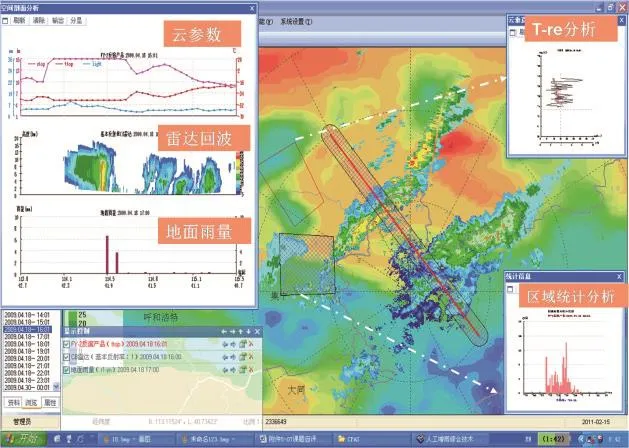
图 1 云降水精细处理分析系统(CPPAS)界面Fig. 1 Cloud and Precipitation accurate Process and Analysis System (CPPAS)

图 2 人工影响天气用“37”高炮炮弹成冰核率在云室中的检测Fig. 2 The nucleation rate testing of “37” artillery shell used in weather modifcation in cloud chamber
Progress in Studies of Clouds, Precipitation, and Weather Modifcation
1 Observational and numerical modeling studies of cloud and fog physics
1.1 TRMM-retrieved cloud structure of MCSs over the South China Sea and comparisons with cloud-resolving models
The structure and evolution of clouds in mesoscale convective systems (MCSs) retrieved from the Tropical Rainfall Measuring Mission Microwave Imager (TRMM/TMI) and precipitation radar (PR) were investigated and compared with pioneer studies based on soundings and models over the South China Sea (SCS). The impacts of convective available potential energy and environmental vertical wind shear on MCSs were also explored. The main features of MCSs over the SCS were captured well by both TRMM PR and TMI. However, the PR-retrieved surface rainfall in May was less than that in June, while the reverse was true for TMI. TRMM-retrieved rainfall amounts were generally consistent with those estimated from soundings and models. However, rainfall amounts from sounding-based and PR-based estimates were higher than those retrieved from TRMM/TMI data. The Weather Research and Forecasting (WRF) modeling simulation underestimated the maximum precipitation rate by 22%, compared to that derived from TRMM PR, and underestimated mean rainfall by 10.4%, compared to the TRMM/TMI estimate, and by 12.5% compared to the sounding-based estimate. The warm microphysical processes modeled by both the WRF and the Goddard Cumulus Ensemble models were very close to those derived from TMI, but the ice water contents in the models were relatively reduced compared to those provided by TMI. (Guo Xueliang, et al.)
1.2 Analysis of comprehensive observations of an artifcial precipitation enhancement operation for a convective-stratiform mixed cloud
Based on cloud physical observations and cloud seeding experiment data from Zhangjiakou, Hebei Province on 18 April 2009, the precipitation enhancement seeding conditions and cloud precipitation development within convective-stratiform mixed clouds were studied alongside satellite, radar, radio sounding, and precipitation observations, amongst other data. The results show that the precipitation cloud system comprises convective-stratiform mixed clouds with large amounts of supercooled water, which is very suitable for seeding, and during the seeding period, the highly seeded region is the main part of the operating clouds. There are some relationships between cloud seeding ability and radar echo. The intensity of C-band radar echo is in good accordance with the precipitation particle spectrum but weak relative to the cloud particle spectrum. After the seeding operation, the concentration of small particles decreased, while large cloud droplets and raindrop concentration increased, and the radar echo showed a bright band in the relevant position. By calculating the rainfall variation rate between the seeding region and a contrasting region, a method of analyzing the seeding effect is proposed. The calculated result shows that the rainfall increase occurs 3–4 h after the seeding operation, and the rainfall amount increases by 120%–180%. (Zhou Yuquan, Cai Zhaoxin, Cai Miao)
1.3 Effects of vertical inhomogeneity of clouds on refectance in the 3.7 μm channel
The satellite’s 3.7 μm channel is widely used in the retrieval of the effective radius of cloud droplets. To know the effects of the vertical inhomogeneity of cloud droplets on the refectance of this channel, the 3.7 μm refectance is calculated separately for two particle profles based on the SBDART radiative transfer scheme∶the droplet effective radius in a vertically stratified homogeneous distribution, and the droplet effective radius in a vertically continuously changing distribution. For the frst profle type, if thin clouds are present, with an optical thickness of less than 10, noticeable errors will exist when the effective radius of verticallyinhomogeneous cloud is retrieved as if it was vertically homogeneous cloud; the error decreases with an increase in optical thickness. If the cloud is suffciently thick, with an optical thickness greater than 10, then the error will be less than 10%. In this case, we may consider that the changes in the cloud droplets’ vertical structure do not infuence the refectance in the 3.7 μm channel. For the second profle type, the results show that when the optical thickness is large, the 3.7 μm refectance is only affected by the cloud parameters in the shallow region near the cloud top, called the effective radiation layer, whose optical thickness is 3–10. There is a negative correlation between the optical thickness of the effective radiation layer and the droplet effective radius near the cloud top, the solar zenith angle, and the satellite zenith angle, but there is no noticeable relationship between optical thickness and the relative azimuth angle. (Zhou Yuquan, Liu Hao)
1.4 Discriminating cloud area from L-band sounding data
Using L-band sounding data from January 2008 to December 2009 along with accompanying spatial and temporal CloudSat data, the cumulative frequency distributions of relative humidity within and outside the clouds are analyzed. In this, the accuracy rate for discriminating cloud was up to 81% if the relative humidity threshold was set at 75%. The performance of different thresholds of relative humidity for discriminating cloud are evaluated through BS and TS, and by setting the relative humidity at 81%, the TS score reaches the highest value of 0.66. Relative humidity thresholds at different heights are analyzed by BS and TS, and the results show that the relative humidity threshold with the highest TS score at its respective cloud height decreases as height increases. Using each threshold for its respective height, the total TS score is higher than 0.6, and the accuracy rate is greater than 84%, which is superior to using only one relative humidity threshold. After optimizing these thresholds, a method using L-band sounding data across China is established to discriminate the vertical structure of clouds. (Cai Miao, Zhou Yuquan, Ou Jianjun)
2 Cloud physics and artifcial seeding simulation research
2.1 Relationships between bell-shaped terrain dynamic forcing, mountain wave propagation, and orographic clouds and precipitation
Orographic clouds and precipitation play a critical role in regional water cycles, fresh water resources, ecosystems, environment, and climate change. The relationship between bell-shaped terrain dynamic forcing, mountain wave propagation, and orographic clouds and precipitation, and their formation mechanisms were investigated in a conditionally unstable moist atmosphere on 1 May 2009, using the WRF model and the wet Froude number (Fw). The results show that at a topographic height of 2 km and a half-width of 10 km, when unstable airfow gradually increases from 2.5 to 25 m s-1, Fw increases from 0.19 to 1.81. The terrain block plays a major role when Fw≤1 and the orographic clouds induced by terrain dynamic lifting form on the windward side, while mountain waves form mainly over the windward side and propagate toward the upstream region, which forms stratiform clouds at first which then evolves into quasi-stable shallow convective wave clouds. Maximum precipitation occurs at the terrain crest near the windward side; however, when Fw is very small, no precipitation is produced. When Fw>1, the orographic clouds induced by terrain dynamic lifting form primarily at the terrain crest, and mountain waves form mainly over the leeward side and propagate toward the region downstream of the crest, producing quasi-stable shallow convective wave clouds in the downstream region. In addition, in a weak and conditionally unstable moist atmosphere, orographic precipitation is produced mainly by warm microphysical processes induced by terrain lifting, and mountain wave clouds are unable to produce precipitation. (Guo Xueliang, et al.)
2.2 Implementation of cloud analysis with radar data in the nowcasting of hail clouds
Using the ARPS/ADAS cloud analysis system, the radar refectivity factor was introduced into the initial feld of the mesoscale numerical model, and a severe hailstorm that occurred in Beijing on 23 June 2008 wassimulated. The study indicated that the hydrometeors and temperature feld in the initial input are improved signifcantly by the introduction of radar refectivity, and this makes the initial feld a closer representation of the actual atmosphere. Compared with the tests conducted lacking this cloud analysis, the simulations with the cloud analysis are better in terms of the generated position of the hail cloud, hail cloud intensity, and motion paths, especially in the simulation results within the frst three hours. With the cloud analysis, the simulation shows that precipitation and hail began an hour earlier, and the precipitation and hail peak values also occurred earlier. The model’s spin-up time was also reduced with the introduction of radar refectivity information. (Guo Xueliang, et al.)
2.3 Microphysical processes research into the AgI seeding simulation for decreasing the heavy rainfall in South China
Using a three-dimensional cloud mode coupled with the AgI seeding scheme, the microphysical processes of a seeding case with heavy rainfall were simulated. The results show that graupel and ice mixing ratios increase greatly with AgI seeding, while the supercooled cloud water content is signifcantly depleted by ice nucleation processes, and supercooled rain water is mostly used up by collection in ice particles and freezing to graupel, collection by graupel, and freezing to graupel. Melting of graupel and evaporation are the most important source and sink terms, respectively. When seeding, the total amount of melting of graupel to rainwater is decreased, which reduces the amount of rainfall. However, after seeding, although this melting process returns to its normal value, many more smaller rain drops in the seeding simulation are evaporated before they fall to the ground than in the natural case simulation, thus resulting in reduced rainfall in the seeding case. (Lou Xiaofeng)
2.4 Characteristics of atmospheric stratifcation and cloud physics for different types of freezing rain over southern China
Three classical freezing rain processes over southern China were simulated using observational data and a CAMS mesoscale cloud model, and the characteristics of atmospheric stratifcation, cloud physics for the freezing rain, and the mechanism of freezing rain formation were analyzed. The results show that∶
(1) A necessary condition for freezing rain is the presence of a temperature inversion layer. An inversion layer with high humidity in the lower atmosphere is often associated with freezing rain.
(2) Formation of freezing rain requires three main conditions∶ a freezing layer existing in the upper troposphere, a warm temperature inversion layer existing blow the freezing layer, and a cooling layer with temperatures below 0 °C with high humidity existing near the surface.
(3) Two different types of temperature stratification could be present during freezing rain∶ “cold–warm–cold” and “warm–cold” stratification. Corresponding to the two types of stratification, two different microphysical cloud structures exist with two different accompanying mechanisms of freezing rain formation.
Considering the “cold–warm–cold” stratification, deeper cloud thicknesses were observed over Hunan Province on 28 January 2008 and Jiangxi Province on 5 January 2010, in which there was a large amount of ice-phase particles. These clouds belonged to mixed-phase cloud. Freezing rain over Hunan and Jiangxi provinces at these times was formed by ice-crystal melting mechanisms, in which freezing rain developed as falling snow encountered a layer of warm air allowing the snow to completely melt and become rain. As the rain continued to fall, it passed through a thin layer of cold air just above the surface and cooled to a temperature below freezing, forming supercooled drops. When the supercooled drops struck the ground, or anything else below 0 °C, they instantly froze, forming freezing rain. The clouds above the freezing rain area over Hunan and Jiangxi provinces were mixed-phase clouds. However, clouds above the freezing rain area over Guizhou Province on 28 January and 9 February 2008 were warm clouds∶ the cloud thickness was thinner, cloud top temperature was higher, and clouds had few ice-phase particles. Considering the “warm–cold”stratifcation type, the freezing rain over Guizhou Province was formed by supercooled warm rain processes,such as the collision–coalescence process. Supercooled raindrops developed as microscopic cloud droplets collected one another as they fell. Ice processes were not involved in the formation of these raindrops.
(4) Over the different freezing rain zones within the same weather systems, differing temperature stratifcations, cloud microphysical structures, and freezing rain formation mechanisms can exist in different types of cloud. Freezing rain zones with the same features can also exist in different weather systems, namely the temperature stratifcation for freezing rain formation, cloud microphysical structures, and the mechanism of freezing rain formation can be the same. (Tao Yue, Li Hongyu, Liu Weiguo)
2.5 Infuences of sub-grid convective processes on cloud forecast in the GRAPES global model
The purpose of this study is to improve the prediction of hydrometeor water content, cloud fraction, and grid precipitation by the Global/Regional Assimilation and Prediction System (GRAPES) global model at 50 km spatial resolution for low latitudes and equatorial regions. This study adopts a new scheme that considers the impact of sub-grid convective processes by adding source/sink terms into the prediction equations of cloud water/ice and cloud fraction. Distinct forecast results from the previous cloud scheme are obtained. The forecasts of cloud and precipitation at low latitudes and in equatorial regions are signifcantly improved after the consideration of the effects of sub-grid convective processes. Moreover, compared with observational data from the Clouds and the Earth’s Radiant Energy System and TRMM, it can be confrmed that the forecasting capability of the GRAPES global model has been improved, especially for cloud and precipitation in the tropics, where the proportion of grid-scale precipitation enhancements increases from 5% to 25%. Further analysis reveals that the influence of sub-scale convective processed on grid-scale cloud and precipitation depends on the distribution and the intensity of the updraft mass fux, which appears larger in the tropics in the new scheme, leading to noticeable increases in cloud and precipitation there. In addition, the maximum updraft mass fux is seen in the 450–650 hPa layer, resulting in a pronounced improvement in the forecasting of middle-level clouds compared to high and low-level clouds, and which causes the cloud top to rise and the cloud bottom to drop vertically downward. (Tan Chao, Liu Qijun, Ma Zhanshan)
3 Progress in weather modifcation capacity-building and operation
3.1 Project progress of weather modifcation capacity-building in Northeast China
The milestones reached during 2013, the second year of the project, have been the approval of the budgetary estimate of the preliminary design; the beginning of the construction of the two MA60 airplanes; the selection of the third type of high-performance airplane, completion of the single source procurement, and modifcation of its airborne probe instruments; and the design and the successful evaluation of the air-ground communication sub-system for the high performance airplanes. The following purchase contracts have been signed∶ seventy-nine GPS/METs, two X-band and one C-band mobile Doppler weather radars, one domestic automatic GPS sounding system, application software for the weather modification command system, 106 6-parameter automatic weather stations and 185 two-parameter automatic weather stations, 40 automatic soil moisture observation stations, and four microwave radiometers. The bid for two MA60 airplane trusteeships was also made in 2013. (Chen Yue, Qian Yao, Fang Chungang, Tan Chao)
3.2 National weather modifcation professional system development and operation
Based on many years of scientific research and related operational projects, the independent national weather modification professional systems of weather modification center of CMA have been initially completed and formally put into operation after one year’s concentrated efforts.
The national weather modifcation professional system is organized by three major operational systems∶the comprehensive analysis and consultation platform, the product processing and shared services platform,and the data acquisition and integration processing platform. The functions of the system are as follows∶providing operating conditions for monitoring and forecasting for different needs, providing designs for seeding plans and tracking guides, allowing visual consultation of operational decisions analysis, monitoring for national real-time aircraft and ground operations and airspace conditions, comprehensive analysis of seeding information and effects, multisource cloud precipitation data collection and processing, and product manufacture and sharing, amongst others. The system integrates many scientific and technological achievements, the core technologies of which are accurate cloud precipitation processing, analysis, monitoring, and cloud model forecasting. Since the national weather modifcation professional system was put into use, the operation guide and the service effects of the weather modifcation center of CMA have been developed and improved. It also provides technical support to local weather modifcation operations and scientifc research (Fig. 1). (Cai Miao, Zhou Yuquan)
3.3 Weather modifcation operational model system and its application
The weather modification operational model system (2013 version) is developed by the Weather Modifcation Center of CMA. The system includes both the MM5_CAMS and the GRAPES_CAMS models. The start times for forecasts are 08∶00 and 20∶00 LST every day, and the forecast time is 48 h. This system has run continually and stably from July 2007, with a fault rate less than 3%. It has high automation and incorporates the complete procedure, and the system passed through the acceptance check of the Disaster Mitigation Division of CMA in December 2013 and was put into operation on 18 April 2014.
MM5_CAMS and GRAPES_CAMS models are coupled CAMS microphysical schemes with MM5v3 and GRAPES, respectively. The CAMS microphysical scheme was developed in 1979 and matured into a two-moment mixed phase explicit scheme in 2000. The six hydrometeors of this scheme are water vapor, cloud water, rain water, ice, snow, and graupel. The model forecasts both water content and the numerical concentration of each of the hydrometeors. A quasi-implicit method is used to assure the positive value, conservation, and the stability of the calculation of cloud physical variables. The CAMS microphysical scheme gained the first prize for “Meteorological Science and Technology Research and Development of CMA in 2005.”
The products of the weather modifcation operational model system (2013 version) can be divided into four types. The first is macroscopic field, which includes cloud band, the temperature of the cloud top, the height of the cloud top, vertical integration of supercooled water, and the vertical integration of liquid water. These help to understand the intensity and the development of the cloud. The second product type consists of microphysical field, which includes the distribution of all hydrometeors. These help to understand the microphysical structure of clouds to determine the seeding area. The third type is vertical cloud structure, which includes the vertical distribution of cloud particles, temperature, and wind. These help to understand precipitation properties and cloud structure to determine the optimum seeding height. The fnal product group is the precipitation over 1, 3, 6, and 24 h. These help to understand the development of precipitation over time.
The products of this system may also be divided into data and images. The data products are distributed to all provincial level meteorological bureaus by the National Meteorological Information Center. The image products are distributed in real time by the Products Share and Distribute System of the Weather Modifcation Center of CMA. The address for this resource is http∶//10.30.24.26∶8080/ryzdcp for CMA, and http∶//10.1.64.228∶8080/ryzdcp for all other provincial level meteorological bureaus.
The Weather Modification Center of CMA has used this model system in addressing serious drought, extinguishing of forest fires, and important social activities from July 2007. Nearly 100 special reports of seeding condition forecasts have been made, which have guided provincial weather modifcation operations. (Shi Yueqin)
3.4 Services in combating high temperature and drought in southern China in 2013
During July and August 2013, unusual and continued high temperatures and drought occurred in 12provinces across southern China. To combat this high temperature and drought, the Weather Modification Center of CMA launched monitoring and forecasting services regarding rain enhancement conditions. The weather modifcation model system and cloud and precipitation monitoring system were used to analyze and forecast the cloud structure in southern China. These monitoring and forecast products were sent to each command center of southern China in real time, totaling 22 special reports. During this time, three types of cloud system were identifed∶ spiral cloud systems of a typhoon (type I), locally convective cloud system of a subtropical high (type II), and a low pressure circulation cloud system following the landing of a typhoon (type III). The weather modifcation models forecast types I and III cloud systems well, whereas the position forecast of locally convective cloud shows some bias. The three types of cloud system have a mixed-phase cloud structure, and the seeding condition in each is very good due to the abundant supercooled water. The forecast of potential seeding areas contained the principal rain enhancement work area for plane and rockets, and as such, these forecast products played an important role in guiding the rain enhancement work. However, there is still much more research to be conducted into the structure and seeding conditions of the summer cloud systems in southern China. (Sun Jing, Shi Yueqin, Zhou Yuquan)
3.5 Test of ice nucleation effciency by 37-artillery shells using new laboratory assessment equipment
During November and December 2013, researchers from the Weather Modification Centre of CMA, the weather modifcation offce of Jilin Province, and the Shanghai Supply and Delivery Division of CMA, along with factory technical staff (No. 152 Factory and No. 3305 Factory of The People’s Liberation Army), conducted measurements into nucleation rates and threshold temperatures in the nucleation rate test department of the Key Lab of the People’s Government of Jilin Province and the CMA, which is located in Dunhua City, Jilin Province. The sample shells are produced by two 37-artillery shell factories. This is the frst time that shells have been tested in China with the same cloud and explosion chambers, instruments, and equipment, and with the same test process and method. In 2012, we designed and constructed a 1.2 m3isothermal cloud chamber and supporting equipment with the foundation support of the National Northeast Weather Modifcation Construction Project. Completion of the new equipment and the underground explosion chamber provides the basic conditions for testing explosion-type seeding agents, and lays the foundation for studying uncertain factors of the seeding agents, such as the nucleation rate, storage time, and dosage, among others (Fig. 2). (Wang Guanghe, Su Zhengjun, Fang Wen)
猜你喜欢
军事文摘(2022年8期)2022-11-03
成都信息工程大学学报(2021年4期)2021-11-22
黑龙江气象(2021年2期)2021-11-05
气象水文海洋仪器(2021年2期)2021-06-30
小学科学(学生版)(2021年3期)2021-04-13
哈哈画报(2021年11期)2021-02-28
农业灾害研究(2019年6期)2019-09-10
疯狂英语·新读写(2018年3期)2018-11-29
创造(2018年8期)2018-11-02
安徽农业科学(2017年24期)2017-07-13