腹地规划设计的教学实践研究
2024-02-19 00:00:00细见狮人
城市设计 2024年4期


摘 要 本文介绍了清华大学英语课程建筑学硕士项目于2023年开展的设计研究课程的方法和研究成果。该研究旨在探索中国腹地地区发展的替代策略,重点关注浙江省丽水市的万象山地区。通过整合城市和建筑方面的考虑,该项研究采用比较案例研究、大数据分析和实地调查等方法来应对腹地发展的复杂性。研究揭示了通过敏感的、基于地方的干预措施促进经济增长的同时,保护历史、文化和生态价值的重要性。通过实际的设计研究和教育合作,该项目探索了振兴腹地地区的整体方法,为中国腹地地区可持续和包容性发展提供全新的视角。
关键词:腹地;设计研究;城市规划;浙江丽水
0 引言:中国城乡定义的演变
本文介绍了清华大学建筑学院英文硕士团队在2023 年进行的设计研究项目,并关注中国腹地地区发展的替代策略。这些介于农村与城市之间的腹地地区往往被忽视,亟须制订针对腹地地区的具体设计策略。研究项目旨在通过多学科的教授和来自不同背景的国内外硕士及本科学生的合作,探索应对这一领域普遍问题的潜在方法。
本文提出了一种适用于通常被忽视的,位于农村与城市之间地区的项目策略,旨在探讨开发建设农村与城市之间腹地地区的新方式。本文将腹地地区定义为“未来前沿”,指出了所选地段的问题,总结了所采用的教学和研究方法,并描述了研究项目的成果,此研究项目中的理念为未来的进一步研究提供了具有参考性的建议。
1 腹地地区作为未来前沿
自1978 年改革开放以来,中国现代化进程中城市化成为核心构成[1]。然而,过去20 年来,农村地区的发展潜力日益受到各方关注。政府明显转向关注农村地区的发展潜力,制订的政策包括国家乡村振兴战略和取消农业税。这一转变并非试图在农村环境中复制城市模式,而是要在一定程度上降低城市快速发展带来的不利影响,如区域发展不均衡、高房价、环境污染和文化同质化等,旨在促进更可持续的生活方式和与自然的平衡关系,并将城市带来的部分经济收益回馈给农村。
由此导致的农村人口的流失和模式的变化,引发了Araghi、Ghosh S 和Meer A 所称的“全球去农民化”现象[2-3]。这个问题与设施迁移现象密切相关[4],涉及对乡村或其他具有重要环境价值地区的自然和文化资源的利用,还推动了郊区化的扩张[5],导致城市土地扩张和核心城市与腹地区域关系的重新定义。2012 年以来,国家层面明确提出实施新型城镇化战略,推动缩小城乡发展差距,中央政府在2024 年年初强调腹地建设[6] 国家战略。浙江省和其他地区提出了相应的政策并加以推广,作出了地方实践的先锋示范[7]。国家和地方层面新型城镇化工作的重点,即是本文讨论的腹地规划设计目标。既有措施发挥了重要作用,但规划师和建筑师需要从设计角度反思这些问题,批判性地参与替代空间配置,探索在农村空间中实践的新方式[8]。
因此,介于乡村与城市之间的腹地地区成为应对这些挑战的未来前沿。新型城镇化发展战略将在中国腹地地区发挥关键作用,使其成为观察创新趋势和试验项目的重点区域。本设计研究课程利用腹地地区,通过整合城市和建筑因素,为新型城乡规划作出贡献,为腹地地区可持续和包容性发展提供全新视角。
2 场地介绍:浙江省丽水市万象山地区
浙江省丽水市的万象山地区,是本文提及腹地地区的典型代表。该地区存在显著的城乡差异、不完善的基础设施和不均衡的产业发展。在重大基础设施方面,尽管有丽水经济技术开发区等项目作为支持,但区域总体建设进度落后,区域配套设施仍不完善,产业布局转型尚未完成,目前仍集中在传统农业领域。作为县级市,丽水市既没有直接受益于其他地区成功实施的乡村振兴政策,也未享受到邻近中心大都市的城市化战略。这些特点充分体现了丽水作为被忽视,且错失发展机遇的腹地地区的典型代表,而不是一般的城乡区域。为实现城乡发展的均衡化,该地区需要通过制订更加全面和创新的发展策略来解决这些问题。然而,丽水却努力发掘自身的特色和发展潜力,将自己定位为“国际摄影名城”,推出中国首个国际摄影节,并充分利用其摄影胜地的中心位置[9]。
本次项目在万象山地区的工业遗址区域进行设计研究,该区域位于原历史城墙之外,临近瓯江,是20 世纪60 年代中国工业时期的工业生产基地,基地内部还有油泵厂旧厂房、宿舍和工人食堂等相关设施。随着工业的搬迁和城市的扩张,该区域成为新开发项目的重要节点。随着丽水国际摄影节的成功举办,该区域已成为一个临时展览场所,并正在寻求更持久的发展战略。因此,万象山地区的未来应与其独特的定位、传统遗产和现代文化创意特色一致。15 年以来,相关部门曾对丽水市万象山地区做过多次规划,也有投资企业提出纯商业开发的设想。根据《丽水国际摄影名城发展规划(2021—2030 年)》,万象山地区的具体控制性详细规划已经完成。项目概念框架得到了加强,《万象摄影公园项目建议书》和《丽水摄影文化中心可行性研究报告》获得批准,从而进入了项目的全面土地征收过程。
此外,丽水作为国家生态保护和建设示范区,对于协调人类和自然生态系统的关系至关重要。在不破坏自然环境的前提下,保护当地动植物群落,并提高其质量是一项关键任务(图1)。这需要扩展该区域功能,融入更多的区域元素,避免完全拆除和重建,并与地方政府合作,寻求更新的发展途径,从多个角度达成共识。鉴于当前的城市发展战略,规划和设计废弃的城市土地,以优化内部空间模式和提高土地利用效率已成为一项关键任务。这一举措不仅可以振兴废弃的城市区域,还为人们提供了反思和重塑建筑和景观的机会,使万象山地区成为新替代策略开发的典型案例。2021 年,丽水编制出台第二轮《摄影十年计划》,概述了其整体定位和发展目标。2021 年6 月,搬迁项目正式启动。为确保项目的顺利实施,市级和区级政府部门在10 多次集体讨论和50 多次修订中,广泛讨论并修订了搬迁计划,在区长办公会议和市政府常务委员会上讨论后,最终政策方案得以形成,反映了各级政府部门对文化推广和建设丽水“国际摄影城”的高度重视和支持。然而,丽水摄影园区的初步规划建议显著增加场地内的商业建筑,以满足经济发展需求。这种基于现有的城市发展策略的开发方式,忽略了腹地地区本身的潜在性,对于不需要这种规划的地区而言,这是一个不现实且过度商业化的项目,使得当地利益相关者缺乏明确的发展途径。因此,为万象山这样的腹地地区提出新的开发策略,是应对发展挑战的一个重大突破。
新的开发策略应该注重因地制宜,提高土地利用效率。这一举措不仅振兴了被遗弃的城市区域,还为类似地块的战略设计提供了发展契机,为腹地发展开辟了一条可持续的创新之路。
3 综合性设计教育
本研究项目结合清华大学研究生16 周设计教学课程进行,分为前8 周的城市设计和后8周的建筑设计两个阶段,在丽水腹地的背景文脉下,从城市和建筑两个领域进行全面的考察和分析。本项目不仅有建筑学专家参与,还有城市规划专家的深入介入,体现了此项工作的跨学科特性。这种跨领域的合作汇集了各种观点和专业知识,促进了研究方法的多样性和丰富性。项目弥合建筑与城市规划之间的差异,探索这两个学科之间的协同效应和交叉点,最终为丽水腹地带来更全面、更综合的设计方案。
通过这种多学科专家的合作,项目参与者深入分析了腹地发展的复杂性,并从空间设计、环境可持续性、社区发展和文化保护等多个角度获得了深刻的见解。利用建筑和城市规划专家的集体智慧和技能,该研究项目旨在更细致和有效地应对腹地发展相关的挑战和机遇。
4 课程研究方法
该课程的主要教学方式为:让学生解决一个城市设计问题。问题空间以特定的方式定义,以促进学习目标的实现。由研究人员和从业人员联合教学,学生学习如何解决复杂的城市设计问题,课程内容包含个人和小组评判、练习、演示、小组讨论、讲座、实地考察。除了上述设计课程部分,整个设计教学结构可分为以下3 个部分。
1)比较案例研究方法。
研究使用比较案例研究方法作为理论基础,结合当地文化背景和来自全球10 多个国家的参与学生的文化多样性。这种多样性是教育设计研究的核心部分,也涉及来自米兰理工大学的研究生交换生,以及清华大学本科生在设计活动中的合作。
2)大数据分析。
首先使用大数据进行分析,如地理空间数据挖掘和空间聚类,提供了对实际场地条件的全面了解,使项目参与者能够详细检查周围环境,包括土地使用模式、城市基础设施和兴趣点POI 的空间分布。此外,提取高度点,在场地范围内生成高分辨率的数字高程模型DEM。这种综合方法,实现了对项目区域内地形和地貌的更准确和详细的评估,有助于在规划和设计过程中做出知情的决策。
3)实地调研以及当地合作。
除了在丽水市万象山地区进行的实地调研和测量外,该项目团队还在丽水摄影博物馆与地方政府召开了讨论和交流会。在会议期间,团队成员介绍了初步的城市规划策略,并收到地方政府对丽水摄影文化和产业整体提升的建设性反馈。
这种综合性设计教育和课程研究方法,使对丽水腹地的发展战略得到了细致而有效的研究成果,重点关注对具体腹地地区的理解,有助于制订更可持续、更符合当地情况的城乡规划。
5 研究成果:丽水万象山摄影园
当地政府对于丽水“国际摄影城”的最初规划方案沿用了城市发展策略的商业开发模式,在拟定的方案中,万象山摄影园区呈现的高密度建筑群忽略了腹地地区本身的自然环境特征,并且在经济方面缺乏可实施性。该园区具有工业遗址和长久的历史文脉,以及丰富的植被和景观资源,最初规划采取典型城市高密度商业模块的植入,难免使投入和资金无法得到有效的回报,同时导致土地利用效率的低下。因此,需要重新考虑符合腹地地区特点的“最小干预、最大效果”的替代策略。
为应对腹地地区规划带来的挑战,该项目团队针对丽水的特定发展需求进行了战略性调整。当地政府最初规划的用地方案,为万象山地区设定了按照典型城市规划界定的项目分区。最初规划将整个区域分为3 个部分:第一部分是新建独立公共建筑区(A-1 区);第二部分是保护区(A-2 区);第三部分是新建开发区(A-3 区)。在最初规划中设置了大量的建筑面积,但未验证该地段是否需要大量的建筑面积,同时也未考虑该地段是否能够容纳最初规划的建筑面积(图2)。因此,在本项目规划阶段,确保容积率保持1.3 的前提下,优先考虑缩小“新建开发区”的范围,并使新建区与保护区相连,避免出现过度碎片化的区块。该略具备两方面优势:一方面,将开发集中在重点区域,为自然景观和现有树木预留了空间。另一方面,缩小新建区域的范围,并相应减少规划的总建筑面积,缓解了对现有建筑和场地环境条件的限制,并保证空间规划的自由度,同时减少了项目对经济和环境的影响(图3)。
根据上述比较案例研究方法、大数据分析、实地调研以及与当地合作,了解植被的位置和种类,考虑地形、河流、建筑空间和交通情况,对最初规划方案进行了优化,进而提出一个合适的综合性规划策略。以下是丽水市万象山地区城市综合性规划策略的5 个不同层面和项目定位介绍。
5.1 区域划分与不同建筑类型
5.1.1 政府意向与区域划分
根据上述规划,该地区划分了4 个保护区和3 个需要建设约5 万m2 新建筑的开发区。4个保护区包括丽水摄影文化中心、 万象摄影文创园区、 万象摄影坊、 万象摄影自然休养区;3 个新建区包括商业与市民中心、 艺术家居住区、文化中心。
这一区域划分既能确保遵守当地政府最初的规划开发要求,又能促进土地高效利用。4个保护区在保持自然景观和历史背景的基础上,进行交通改善与建筑保留,而3 个开发区在考虑保留现有功能的基础上,仔细评估了与新增功能的整合,确保新的建筑空间能够满足丽水摄影节的需求。万象山地区的分区策略兼顾了保护与开发,并各自采用不同的功能和建筑设计方案,以激活整个地区。
5.1.2 工业遗址
从现存建筑风貌来看,该区域内建筑多为红砖厂房,体量相对较大,具有很好的保留和改造价值。其他原居住区域及部分体量较小的建筑区域稍显凌乱,私搭乱建较为严重,无留存价值。经建筑评估后,确定了应保留的建筑风貌情况。考虑其建筑风格、材料和整体特点,辨识出具有历史和文化意义的建筑物,这一过程确保了场地独特的建筑身份。在拆除和场地清理过程中,基于生态建构的理念,对影响环境和产生废物的潜在问题保持高度关注。实施策略为尽量减少废弃材料,对拆除结构物中的材料进行再利用。在可行的情况下,对可再利用的材料(如砖块、瓦片等)进行分类和储存,以便将它们用于新的建筑中,这不仅减少了建筑废物的产生,还为重新开发增添了一层真实性和连续性。
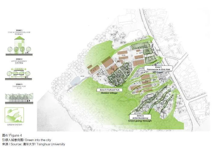
5.1.3 引绿入城
万象山公园的渐进式绿色建设,强调“融山汇水,透绿进城”的设计理念,旨在保护当地生态,并促进可持续发展,同时满足当地居民的居住需求。从市区向公园递减开发强度,使生态环境和建筑设计相互融合,相互渗透。
在实地考察中,发现园区内自然植被茂盛,尤其是体态优美的桂花树和茶花树,形成了一个宜人的树下空间,给人一种宁静和舒适的感觉,仿佛进入了世外桃源。为尽可能地保护和保留这些树木,并在园区内新增创意文化功能,考虑空间布局和景观形态的合理性,以确保新功能与自然环境相协调。
根据树木郁闭度、视线规划、树种和气候条件,对现有场地树木和新增绿化植被进行有机区域划分和融合,以实现生态建设的目标。保护现有的树木并结合新的种植计划,创建一个绿色廊道体系,使项目场地与周边城市景观在视觉上畅通(图4)。此外,基于不同建筑类型采纳不同种植方法。
(1)三维庭院: 在市政商业区,实施垂直绿化,打造立体庭院。
(2)三维村落: 在艺术家驻留的艺术社区,引入绿化渗透。
(3)隐约聚落: 酒店文化区作为隐约的聚落。
多层建筑立面呈现三维的垂直绿化,艺术社区的绿色渗透体现建筑群体与植被环境围合条件下的舒适性造园,隐约聚落的绿植划分保证了独栋酒店之间的私密性与声环境的质量。
5.1.4 水系循环系统
水系循环系统的设计建立在现存场地的基础上:第一,利用场地地势设置雨水收集沟渠,使园区具有回收利用水资源功能,并实行低影响开发;第二,在重要节点处布置线性绿化带和局部公共开放绿地,为居民提供休闲空间,并为节点的标识性提供基础;第三,使网络结构向滨水广场延伸,加强水系与居民的联系(图5)。
5.1.5 交通组织系统
交通组织系统在现存场地的基础上,设置二进一出的主街道,改善了单线程的原有道路情况,融入了可循环的车型系统和可达性较高的步行系统,由一个大的主循环覆盖整个园区,次干道服务主干道的步行路线和交通枢纽(图6)。
5.2 项目定位
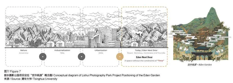
将项目场地与具有地方特点的概念“世外桃源”相连接,体现了回归起源、融入文化遗产,以及在自然环境中找到人居和谐的理念(图7)。因此,项目团队对“世外桃源”的要素进行了深入分析,了解地域性和生态建构,并沿用在项目中。同时,界定设计方案中应该融入的特定条件场地中,需要挖掘的可见和不可见的价值。
在整个设计过程中,这些概念不仅涵盖场地的物理特征,还包含为其独特地段做出贡献的精神要素。认真考虑和融入这些概念,确保项目设计扎根于丽水市万象山地区的空间格局,并与周围城市环境产生共鸣。
5.3 区域划分与不同建筑类型
在城市综合性规划策略的基础上,划分为3 个不同区域的理由为城市规划原则和每个区域的预期功能(图8)。
首先,不同的建筑群体与分区概念一致,并遵循《城市规划指南》中规定的容积率。这确保了每个区域内的开发强度适合其预定用途,同时保持了整体的城市结构。
其次,分区反映了空间的战略性划分,以适应不同的功能和活动。商业及市民中心作为商业和市民活动的交流中心,需要较高的建筑结构(12 ~20m)来容纳商业活动和社区聚会。艺术家驻留区旨在激发摄影艺术家的创意和培养摄影艺术家的社区感,因此倾向于较低的建筑群体(10~12m),以营造安静且有利于艺术创作的氛围。展览+ 工作坊区满足摄影节展览和工作坊的需求,需要混合的建筑高度(10~ 15m),以容纳各种展览空间和工作坊设施。
最后,植被分类和水体考虑对于提升每个区域的功能性和氛围至关重要。在商业及市民中心,采用城市庭院植被,创造宜人且可供公众享用的绿地;而艺术家驻留区则以梯田景观和开放空间为特点,以促进创意和宁静。同样,各种类型的水体,如广场、喷泉、水花园、小溪和池塘,也被战略性地融入每个区域,以补充整体设计和功能,贡献一个充满活力,且可持续的城市环境。
在3 个区域中,每个区域均有其特定的建筑群体、植被和水体,这一划分是由城市规划考虑、规定的容积率(FAR)和每个区域的预期功能共同驱动的。这种方法确保了开发既与环境协调,又响应社区需求,同时创建了一个充满活力和可持续的城市环境。
本策略是基于当地政府提供的初步框架,并通过充分了解该地区的具体情况,探索如何利用“城市战略的不同层次”来整合城市发展战略。这种方法不仅确保地区发展与当地情况紧密结合,还能深入挖掘该地区的特色,为实施更具战略性的城市发展计划提供坚实基础。应用多层次规划中的具体技术,能够将这些见解转化为实际可行的规划,确保腹地地区发展的全面性和可持续性。
中国的腹地地区正在经历变革,需要重新考虑传统的地区保护和扩展方法。现在,需要采用一种策略性的、经济的、环保的方法,以最大化挖掘土地及资源的潜力。强调“最小干预,最大效果”的战略,尊重每个农村遗产和背景的复杂性,创造多功能公共项目,使其成为经济发展的催化剂。
6 结 语
本文在丽水腹地地区的研究中,通过清华大学建筑学院英语硕士课程教育进行的实际设计项目,突显了当代中国发展与规划的关键问题。该项目探索了中国城乡发展的未来前沿——中国腹地地区所面临的挑战。研究发现,常规的城乡规划策略导致了丽水市万象山地区大规模的不适当建筑干预。这一发现促使人们批判和反思在敏感的生态和文化背景下发展实践的适宜性。综合分析和设计提案,旨在为腹地发展提供一种更周到和可持续的方法。整合城市和建筑方面的考虑,倡导优先保护环境、文化,并关注社区空间的质量。
综上所述,本研究中鼓励利益相关者采取更全面和负责任的发展方法,尊重乡村景观的独特特征,促进城乡和谐发展。实质上,这项研究强调了在塑造腹地地区未来发展时知情决策和协作努力的重要性。采用创新设计策略并优先考虑人类和环境的福祉,可以为具有公平性、可弹性、可持续性的城乡起到过渡作用。
参考文献
References
[1] 刘彦随. 中国新农村建设创新理念与模式研究进展[J]. 地理研究,2008,27(2):479-480.
[2] ARAGHI F A. Global depeasantization, 1945-1990[J].The Sociological Quarterly, 1995, 36(2): 337-368.
[3] Ghosh S, Meer A. Extended urbanisation and the agrarian question: Convergences, divergences and openings[J].Urban Studies, 2021,58(6):1097–1119.
[4] ABRAMS J B, GOSNELL H, GILL N J, et al. Recreating the rural, reconstructing nature: an international literature review of the environmental implications of amenity migration[J]. Conservation and Society, 2012,10(3): 270-284.
[5] WU F L, KEIL R. Changing the geographies of sub/urban theory: Asian perspectives[J]. Urban Geography,2020, 41(7): 947-953.
[6] 蒲清平, 马睿. 国家战略腹地建设的内涵特征、重大意义和推进策略[J]. 重庆大学学报( 社会科学版),2024, 30(4):37-48.
[7] 丽水市发展和改革委员会. 丽水市新型城镇化发展“ 十四五” 规划[EB/OL].(2022-05-01)[2024-02-01]. https://zjjcmspublic.oss-cn-hangzhou-zwynet-d01-a.internet.cloud.zj.gov.cn/jcms_files/jcms1/web3657/site/attach/0/29f8a67cdaf54372b9eea0fe6f582fee.pdf.
[8] AMO, KOOLHAAS R. Countryside: a report[M].Köln: Taschen, 2020.
[9] 丽水市发展和改革委员会. 丽水市人民政府关于印发丽水市国民经济和社会发展第十四个五年规划和二〇三五年远景目标纲要的通知[EB/OL].(2020-10-30[2024-02-01].http://www.songyang.gov.cn/art/2020/10/30/art_1229360680_4012078.html.
ORIGINAL TEXTS IN ENGLISH
Exploring Hinterland Design StrategiesThrough Educational Design Research inWanxiang Mountain, Lishui, Zhejiang
Hosomi Shishito
0 Introduction
This paper describes the results of a designresearch studio conducted in 2023 by the English Master Program in Architecture at Tsinghua University’sSchool of Architecture, in which the author was oneof the participants. The studio’s aim was to exploreexploring alternative strategies for developing China’shinterland. Often overlooked, these areas between thevery rural and the highly urban require specific designstrategies. The studio aimed to explore potentialapproaches for addressing prevalent topics in thisrealm through a multi-disciplinary collaboration ofprofessors from various backgrounds and a diversegroup of students, both local and international, frommaster and undergraduate programs.
The objective of the studio was to introducea project strategy that could be applied to similar,typically overlooked areas situated between the urbanand rural, and aims to envision new ways of developingthis Hinterland, which itself is facing significantupheaval. The paper outlines the Hinterland as the‘Next Frontier’, identifies the issues in the chosen site,summarizes the teaching and research methods applied,describes the resulting studio project, and concludeswith recommendations learned from this studio thatcould be useful for further research.
1 The Hinterland as the Next Frontier
Since the reform and opening-up policies of1978, China initially prioritized urbanization in itsmodernization efforts[1]. This focus on urbanizationdrove rapid economic growth and modernization,but also brought about challenges such as regionalinequalities, increased real estate prices, environmentalpollution, and cultural homogenization. In response tothese adverse effects, there has been a noticeable shiftin in the past two decades towards recognizing thepotential of rural areas, including the national RuralRevitalization strategy and the abolishment of the taxon farmers, which was effective in supporting urbandevelopment. Rather than replicating urban modelsin rural settings, this shift aims to promote a moresustainable way of life and a balanced relationshipwith nature, and a way to return and divert someof the economic benefits of urban progress to thedevelopment of the countryside.
The displacement of the rural population andsubsequent changes in settlement patterns haveled to a uniquely Chinese situation, which Araghiand Ghosh S and Meer A describe as ‘globaldepeasantization’[2-3]. This issue is closely tied tothe phenomenon of amenity migration[4], involvesthe exploitation of natural and cultural resourcesin the countryside or other areas of significantenvironmental value. It has also driven an expansionin suburbanization[5], with increased land consumptionand a redefined of the relationships between corecities and their surrounding areas. In the past years,national policies have emphasized a new urbanizationstrategy to reduce the urban-rural development gap,with the central government in the beginning of2024 even highlighting the construction of nationalstrategic hinterlands[6]. Zhejiang province has proposedcorresponding policies to promote new developmentmodels, aiming to create a pioneering example in ethnicregions, revitalizing old districts, and mountainousareas[7]. While these measures are crucial, planners andarchitects must reflect on these issues from a designperspective, engaging critically with alternative spatialconfigurations that promote novel ways of inhabitingand practicing in rural spaces[8].
As a result, the hinterland—the areas that liebetween urban and rural settings—emerges as thenext frontier in addressing these challenges. New types of development strategies will play a keyrole in China’s hinterland, making it an excellentarea to observe innovative trends and experimentalprojects. Therefore, this design research studioutilizes hinterland areas to contribute to new urbanruralplanning by integrating urban and architecturalconsiderations, providing a fresh perspective onsustainable and inclusive development.
2 Site Introduction: Wanxiang Mountain inLishui County Town, Zhejiang Province
For this studio, a site in Zhejiang Province’sLishui County was chosen. Lishui is a County Town,and a typical representative of the hinterland region,exhibiting significant urban-rural disparities andunderdeveloped infrastructure. Despite initiatives likethe Lishui Economic and Technological DevelopmentZone, overall construction progress is disjointed,and regional supporting facilities remain inadequate.The industrial layout transformation is incomplete,focusing primarily on traditional agriculture. Asa county town, Lishui does not directly benefitfrom the rural revitalization policies successfullyimplemented in other parts of the region, nor doesit enjoy the proximity to a central metropolis and itsurbanization strategies. This makes Lishui a typicalexample of a hinterland area that is often overlookedand missing out on development opportunities.Traditional development and design strategies, oftenbased on urban or rural models, do not apply wellhere. However, Lishui has sought to find its uniquecharacteristics and development potential, positioningitself as an ‘International Photography City,’ launchingChina’s first international photography festival andleveraging its central location in a photogenic areawith strong natural greenery[9].
The studio selected the abandoned industrialarea that sits within ‘Wanxiang Mountain’ as itssite. Located just outside the original historic citywalls and next to the main river, it was an industrialmanufacturing worksite during China’s industrialboom, with large factory halls for oil pump productionand related facilities like dormitories and canteens.As the industry was phased out and the townexpanded, this site became a prime location for newdevelopments. Following the success of Lishui’sinternational Photography Festival, it has served as atemporary exhibition site, but the town is seeking amore permanent development strategy. The WanxiangMountain site’s future has the potential to align withits unique positioning, traditional heritage, and recentcultural creative character. Various departments haveproposed plans for the area, with some investmentfirms suggesting purely commercial developments. The“2021-2030 Development Plan of Lishui InternationalPhotography City” has refined the regulatory plan forthe area, strengthening the conceptual framework andinitiating comprehensive land acquisition.
Given Lishui’s designation as a nationalecological protection and construction demonstrationarea, harmonizing human and natural ecosystemsis crucial. This involves preserving local flora andfauna without disrupting the natural environmentwhile improving its quality (Figure 1). Expandingfunctions, incorporating more regional elements, andseeking a renewal development approach with localgovernments were essential to achieve consensusfrom multiple perspectives. This makes the WanxiangMountain site an exemplary case for the developmentof new, alternative strategies. The government’s“2021-2030 Development Plan of Lishui InternationalPhotography City” has already identified thispotential. However, the preliminary planning forthe Lishui Photography Park, which suggested asignificant increase in commercial structures to meeteconomic requirements, was based on existing urbandevelopment strategies. This made it an unrealisticand overly commercialized project for a site that didnot inhibit characteristics of its indentified potential,leaving local stakeholders without a clear path forward.
Therefore, developing alternative strategiesfor hinterland sites like Wanxiang Mountain is asignificant breakthrough in addressing developmentchallenges. This approach focuses on designingfor specific local conditions and increasing landuse efficiency. This initiative not only revitalizesabandoned urban areas but also provides anopportunity to develop a strategic design model forsimilar sites, offering a sustainable and innovativepath forward for hinterland development.
3 Intergrated Design Education
The research project spanned 16 weeks, with 8weeks dedicated to urban studies followed by 8 weeksfocused on architectural exploration. This extendedduration allowed for a thorough examination of bothurban and architectural aspects. At the same time, thestudio emphasized interdisciplinary collaboration,involving professors in architecture, and urbanplanning. A total of four professors, a dedicatedteaching assistant and fifteen students were involved.This effort brought together diverse perspectives andexpertise, fostering a rich and multifaceted approach tothe research. By bridging the gap between architectureand urban planning, the project aimed to exploresynergies and intersections between the two disciplines,ultimately leading to more holistic and integrateddesign solutions for the Wanxiang Mountain site.
Through this multidisciplinary collaboration,participants delved into the complexities ofhinterland development, drawing insights fromspatial design, environmental sustainability,community development, and cultural preservation.By harnessing the collective knowledge and skills ofboth architecture and urban planning professionals,the research project sought to address the multifacetedchallenges and opportunities associated withhinterland development more effectively.
4 Studio Method
The course involved solving a predeterminedurban design problem in a design studio format. Inthis setup students were guided by researchers andpractitioners through individual and group critiques,exercises, demonstrations, discussions, and occasionallectures, as well as an in-depth site visit. The studiostructure comprised three main components:
1) Comparative Case Study Methodology.
This approach incorporated the local culturalbackground and the cultural diversity of studentsfrom over ten countries. Exchange students fromPolitecnico di Milano as well as international and localundergraduate and graduate students collaborated indesign activities, fostering an inclusive, diverse andinternational educational environment.
2) Big Data Analysis.
Preliminary use of big data analysis, includinggeospatial data mining and spatial clustering,provided a comprehensive understanding of theactual site conditions. This method enabled a detailedexamination of the surrounding environment, such asland use patterns, urban infrastructure, and the spatialdistribution of Points of Interest (POI). Integratingaltimetric points extracted from CAD software, ahigh-resolution digital elevation model (DEM) wasgenerated, offering a detailed assessment of theterrain and topography within the project area, whichfacilitated informed decision-making during theplanning and design process.
3) Field Investigation and Local Collaboration.
The team conducted field investigations,interviews, documentation and on site measurements.Additionally, they convened a discussion andexchange meeting with the local government andother stakeholders at the Lishui Photography Museum.During the meeting, team members shared insights onthe park’s conceptual framework, provided valuablerecommendations, and received constructive feedbackfor enhancing Lishui’s photography culture and industry.
This comprehensive approach to integrateddesign education and studio methodology enableda nuanced and effective exploration of development strategies for the Lishui hinterland, focused onsite specific understandings, contributing to moresustainable and contextually appropriate urban-ruralplanning.
5 Studio Results: Lishui Photography ParkApproach
The initial planning scheme for the “LishuiInternational Photography City” by the localgovernment adopted a commercial developmentmodel based on urban development strategies. Inthe proposed scheme, the high-density buildingclusters presented in the Wanxiang MountainPhotography Park neglected the natural environmentalcharacteristics of the hinterland and lacked economicfeasibility. The park possesses industrial heritage anda long historical context, as well as rich vegetationand landscape resources. The initial planningapproach considered a typical urban, high-densitycommercial area implantation, which give the localeconomic characteristics, would lead to inefficientland use and potentially ineffective capital investmentreturns. Therefore, it was necessary to reconsideralternative strategies that align with the characteristicsof the hinterland, embodying the strategy of “minimalinterventions with maximum effect.”
To a d d r e s s t h e s e c h a l l e n g e s , s t r a t e g i cadjustments were made to meet the specificdevelopmental needs of Lishui. The initial landuse plan set by the government for the WangxiangMountain area defined the project constituentsaccording to general urban practice. It zoned the totalarea site into three sections, one for a new stand alonepublic building (A-1 area), one for ‘preservation’ (A-2area) and one for ‘new construction’ (A-3 area), whichstipulates a minimum Floor Area Ratio (FAR) of 1.3.This creates a large amount of floor area to be locatedon this site, and does not consider whether this areais needed, or whether the site can host this amountof square meter (Figure 2). Therefore, as a first stepin the studio, adjustments were made to the sizingof the ‘new construction areas’, letting them overlapwith the ‘preservation zones’, while maintaining theFAR minimum of 1.3, but including the m2 that wasalready available on the site. This has two advantages.It first of all concentrated development in key areas,leaving room for natural landscapes and existing trees.Secondly, by reducing the scope of new constructionareas and accordingly decreasing the total requiredbuilding area, the constraints on existing buildings andsite conditions were alleviated, ensuring a project thatcould better fit the local economic characteristics, andalso allowed more freedom in spatial planning whileminimizing the investment and environmental impactof the project (Figure 3).
The next planning steps were based on thisprinciple, followed by comparative case study and bigdata analysis, field investigations, and interviews withthe local government. Subsequently a comprehensiveanalysis of the existing vegetation location and types,terrain, rivers, building spaces, and traffic conditionswas done. This information was then used to definea suitable, comprehensive planning strategy. Thefollowing introduces the five different levels of urbanstrategy and project positioning for the WangxiangMountain area.
5.1 Five Layers of Urban Strategies
5.1.1 4+3 Zoning Strategy
According to the previous FAR strategy, the areais divided into four preservation zones, and three ‘newconstruction zones’. The preservation zones include:(1) Lishui Photography Cultural Center, (2) WanxiangPhotography Creative Industrial Park, (3) WanxiangPhotography Workshop, (4) Wanxiang PhotographyNature Retreat.
The three new construction zones include: (1)Commercial amp; Civic Hub, (2) Artists Residency, (3)Cultural Hub.
This zoning ensures compliance with the initialgovernment planning requirements while promotingeffective land use. The four preservation zones willmaintain the natural landscape and historical context,with improvements in transportation and the retentionof existing buildings. The three development zones,while preserving existing functions, have carefullyevaluated the integration of additional functions toensure that the new building spaces meet the needsof the Li Shui Photography Festival. The zoningstrategy for the Wangxiang Mountain area balancespreservation and development, each with distinctfunctions and architectural designs to activate theentire region.
5.1.2 Industrial Heritage
In terms of the existing architectural landscape,the buildings in this area are mostly red brickfactories with relatively large volumes, which havesignificant value for preservation and renovation.Other residential areas and some small-scale buildingareas appear somewhat disorderly, with prevalentunauthorized constructions that lack preservationvalue. After architectural assessment, the buildingsthat should be preserved have been identified. Thisincludes recognizing structures with historical andcultural significance, considering their architecturalstyle, materials, and overall characteristics. Throughthis process, the site’s unique architectural identityis ensured. During the demolition and site clearanceprocess, a high level of attention is maintained onpotential environmental impacts and waste generationbased on ecological construction principles.
Implementation strategies aim to minimize wastematerials by reusing and recycling materials fromdemolished structures. Whenever feasible, reusablematerials such as bricks, tiles, etc., are carefullycategorized and stored for use in new constructions.This approach not only reduces construction wastebut also adds authenticity and continuity to theredevelopment process.
5.1.3 Green into the City
The gradual green development of WanxiangMountain Park emphasizes the concept of “green intothe city,” focusing on the protection and sustainabilityof the local ecology, while also taking into account theresidential needs of the local residents. This developmentstarts from the urban area and gradually diminishestowards the park area, with the ecology and architectureintertwining and infiltrating each other.
During the on-site investigation, it was foundthat the natural vegetation in the park is lush,especially the mature osmanthus and camellia trees,which create a pleasant space under the trees, givinga sense of tranquility and comfort, as if enteringa secluded paradise. To protect these trees, effortswill be made to retain them as much as possiblewhile introducing new creative cultural functionswithin the park. To ensure the harmony betweenthe new functions and the natural environment, theoverall vegetation of the project will be dividedinto different zones in Figure 4. Existing treeson the site and new greenery will be organicallyintegrated based on factors such as vegetationdensity, sightline planning, tree species, and climateconditions, achieving ecological constructionfor the project. By protecting existing trees andincorporating new planting plans, a green corridorsystem will be created, visually connecting theproject site with the surrounding urban landscape.Additionally, different planting methods are adoptedbased on different typologies of buildings:
3D Courtyard: In the municipal commercialarea, vertical greening will be implemented to create athree-dimensional courtyard.
3D Village: In the art community for residentartists, a green permeation strategy will be implementedto create a three-dimensional village.
(3) Hidden Village: In the hotel cultural area, ahidden village concept will be applied.
Vertical greening will be implemented on thefacades of multi-story buildings, while the greenpermeation in the art community will focus oncreating comfortable landscaping within the enclosedenvironment formed by the buildings and vegetation.The greenery division in the hidden village conceptensures the privacy between individual hotels and the quality of the acoustic environment. (Figure 4).
5.1.4 Blue System
The design of the water circulation system isbased on the existing site conditions: first, utilizingthe topography of the site to set up rainwatercollection and drainage channels, enabling the parkto recycle water resources and implement low-impactdevelopment; second, arranging linear green belts andlocal public open green spaces at key nodes to providerecreational areas and serve as a foundation for nodeidentification; third, extending the network structureto the waterfront square to strengthen the connectionbetween the water system and the residents(Figure 5).
5.1.5 Circulation System
The design of the transportation organizationsystem is based on the existing site conditions: settingup a two-in-one-out main street improves the originalsingle-thread road situation, incorporating a reversiblevehicle system and a highly accessible pedestriansystem. A large main loop covers the entire park, withsecondary roads serving the main road pedestrianroutes and transportation hubs(Figure 6).
5.2 Positioning with Local Narrative
Linking the project site with a locally distinctiveconcept of “a Garden of Eden” (Shiwaitaoyuan),reflects the idea of returning to origins, integratingcultural heritage, and finding harmony in thenatural environment. Thus, a thorough analysis ofthe elements of this “Garden of Eden” has beenconducted, understanding regional and ecologicalconstructs, and incorporating them into the project(Figure 7). Simultaneously, defining specificconditions for integration into the design scheme,uncovering both visible and invisible values of thesite that need to be explored. With this vision, theproject aims to transform the industrial heritage site intoa thriving center for creativity and cultural exchange,while preserving its unique identity and natural beauty.
Throughout the design process, these conceptsencompass both the physical features of the siteand the spiritual elements contributing to its uniquecharacter. By carefully considering and integratingthese concepts, the project design ensures a deepconnection to the spatial layout of the WanxiangMountain area in Lishui, resonating with thesurrounding urban environment.
5.3 Three Zones with Different ArchitecturalTypologies
On the basis of the urban strategy, the rationalebehind the establishment of three distinct zones liesin both urban planning principles and the desiredfunctionalities for each area(Figure 8).
Firstly, the varying building masses are alignedwith the concept of zoning and adhere to prescribedFAR designated in the urban planning guidelines.This ensures that the development intensity withineach zone is appropriate for its intended use whilemaintaining a cohesive urban fabric.
Secondly, the zoning reflects a strategicpartitioning of space to accommodate differentfunctions and activities. The Commercial amp; Civic Hubserves as a bustling center for commerce and civicengagement, requiring taller structures (12-20 meters)to accommodate commercial activities and publicgatherings. On the other hand, the Artist Residency Zoneis designed to nurture creativity and community amongphotography artists, hence the preference for lowerbuilding masses (10-12 meters) to foster a tranquil andconducive atmosphere for artistic endeavors. Finally,the Exhibition + Workshop Zone caters to the needsof photography festival exhibitions and workshops,necessitating a mix of building heights (ranging from10 to 15 meters) to accommodate diverse exhibitionspaces and workshop facilities.
Thirdly, the classification of vegetation andthe consideration of water bodies are integral toenhancing the functionality and ambiance of eachzone. Urban courtyard vegetation may be employedin the Commercial amp; Civic Hub to create inviting andaccessible green spaces for public enjoyment, whileterraced landscapes and open spaces characterize theArtist Residency Zone to foster creativity and serenity.Similarly, different types of water bodies, such asplazas, fountains, water gardens, creeks, and ponds, arestrategically integrated into each zone to complement theoverall design and function, contributing to a vibrant andsustainable urban environment.
Across all three zones, the division of the siteinto three distinct zones, each with its own buildingmasses, vegetation, and water bodies, is driven bya combination of urban planning considerations,prescribed FAR guidelines, and the desiredfunctionalities for each area. This approach ensures thatthe development is both harmonious and responsive tothe needs of the community while promoting a vibrantand sustainable urban environment.
This strategy is based on the preliminaryframework provided by the local government andexplores how to utilize the “different levels of urbanstrategy” approach to integrate urban developmentstrategies through a thorough understanding of thespecific conditions of the area. This strategy integratesthe preliminary framework provides by the localgovernment with our in-depth research data, creatingdifferent levels in our urban redevelopment strategy.This approach not only ensures that developmentis closely tied to the local narrative but also deeplyexplores the unique characteristics of the region,providing a solid foundation for implementing morestrategic urban development plans. By applyingspecific techniques from multi-level planning,these insights can be translated into practical andfeasible plans, ensuring the comprehensiveness andsustainability of hinterland development.
China’s hinterland areas are undergoingtransformation, reconsidering traditional methods ofpreservation and expansion. The new proposal is toadopt a strategic, economical, and environmentallyfriendly approach to maximize the potential of theland and its resources, that fits with local developmentcharacteristics. Emphasizing a strategy of ‘minimalinterventions with maximum effect’, the planprioritizes the development of multifunctional publicprojects that respect the complexity of each ruralheritage and background, while acting as catalysts foreconomic development.
6 Conclusion
This paper described the study and definitionof the Wangxiang Mountain project in Lishui, asutilised in an educational design project in the EPMAof Tsinghua University’s School of Architecture. Ithighlighted key aspects of contemporary developmentand planning in China and took this site as arepresentative case to show the challenges facedin China’s hinterland, the next frontier in China’surban-rural development. The research found thatconventional urban and rural planning approaches inthe Wangxiang Mountain area led to inappropriatestarting points, with unrealistic ambitions, that did notconsider local market conditions and lead to unsuitablearchitectural strategies, necessitating a criticalreflection on the suitability of development practicesin sensitive ecological and cultural contexts. Throughcomprehensive analysis and design proposals, the studyaims to provide a more thoughtful and sustainableapproach to hinterland development by integratingurban and architectural considerations, advocating forenvironmental protection, cultural preservation, and theenhancement of community spaces.
This research encourages stakeholders to adoptholistic and responsible development methods thatrespect the unique characteristics of rural landscapesand promote harmonious urban-rural integration. Itemphasizes the importance of informed decisionmakingand collaborative efforts in shaping the futuredevelopment of hinterland areas. By employinginnovative design strategies and prioritizing thewell-being of people and the environment, a moreequitable, resilient, and sustainable urban-ruraltransition can be achieved.
猜你喜欢
英语世界(2023年12期)2023-12-28 03:36:06
光明少年(2023年4期)2023-04-29 00:44:03
建材发展导向(2022年2期)2022-03-08 01:43:48
建材发展导向(2021年23期)2021-03-08 01:05:38
中华建设(2019年4期)2019-07-10 11:50:58
继续教育(2016年11期)2016-11-24 20:05:00
数字技术与应用(2016年9期)2016-11-09 23:36:50
文艺生活·下旬刊(2016年10期)2016-11-03 00:02:16
考试周刊(2016年79期)2016-10-13 22:14:57
星星·散文诗(2015年34期)2015-10-26 19:25:18