
Applying the AHP-FUZZY method to evaluate the measure effect of rubble roadbed engineering in permafrost regions of Qinghai-Tibet Plateau: a case study of Chaidaer-Muli Railway
2019-01-05 02:00WeiCaoYuShengJiChenJiChunWu
Wei Cao, Yu Sheng , Ji Chen, JiChun Wu
State Key Laboratory of Frozen Soil Engineering, Northwest Institute of Eco-Environment and Resources, Chinese Academy of Sciences, Lanzhou, Gansu 730000, China
ABSTRACT This article attempts to investigate the measure effect of rubble roadbed engineering in permafrost regions of Qinghai-Tibet Plateau. As a case study, Chaidaer-Muli Railway is used to evaluate the measure effect of rubble roadbed engineering in permafrost regions. The AHP (Analytic Hierarchy Process) method is thus employed to establish the evaluation indicator system. The evaluation factor is selected by analyzing the mutual relation between the permafrost environment and roadbed engineering. Thus, a hierarchical structure model is established based on the selected evaluation indices. Each factor is weighted to determine the status in the evaluation system, and grading standards are built for providing a basis for the evaluation. Then, the fuzzy mathematical method is introduced to evaluate the measure effect of rubble roadbed engineering in permafrost regions along the Chadaer-Muli Railway. Results show that most of the permafrost roadbed is in a preferable condition (b) along the Chaidaer-Muli Railway due to rubble engineering measures. This proportion reaches to 86.1%. The proportion in good (a), general (c) and poor states (d) are 0.0%, 7.5% and 6.4%, respectively, in all the evaluation sections along the Chaidaer-Muli Railway. Ground-temperature monitoring results are generally consistent with AHP-FUZZY evaluation results. This means that the AHP-FUZZY method can be applied to evaluate the effect of rubble roadbed engineering measures in permafrost regions. The effect evaluation of engineering measures will provide timely and effective feedback information for further engineering design. The series of engineering measures will more effectively protect permafrost stability.
Keywords: measure effect evaluation; rubble roadbed engineering; permafrost regions of Qinghai-Tibet Plateau;AHP-FUZZY method; Chaidaer-Muli Railway
1 Introduction
Frozen soil generally refers to a variety of rocksoil and soil with ice at or below the temperature of 0 °C. The proportion of permafrost and seasonal frozen soil is 21.5% and 53.5%, respectively, of the national territorial area in China (Zhou et al., 2000).Permafrost is a special geologic body which is sensitive to temperature. Abundant underground ice is unevenly distributed in permafrost, and moisture in permafrost is prone to migrate and has characteristics of phase change. Therefore, permafrost has rheological properties, and its long-term strength is far lower than instantaneous strength. Thus, permafrost has characteristics of thawing settlement and frost heaving which are two major engineering problems in perma-frost regions. The destruction of buildings in permafrost regions is mainly caused by thawing settlement of the permafrost foundation. Permafrost passively absorbs a large amount of heat from the operation of overlying buildings (Wu and Liu, 2005; Cheng and Ma, 2006). This is especially true for engineering construction in permafrost regions of Qinghai-Tibet Plateau over the past several decades. As the maximum linear engineering structure in Qinghai-Tibet Plateau, Qinghai-Tibet Railway passes through about 547 km of the permafrost region. Railway construction in this region is confronted with severe challenges of high-te mperature permafrost and global warming. Thus, numerous engineering measures have been actively adopted to protect the permafrost and cool the roadbed.These measures mainly aim at maintaining permafrost railway-subgrade stability (Cheng, 2005a,b;Cheng and Ma, 2006; Chen et al., 2015; Hou et al.,2015), and have effectively protected permafrost roadbed stability (Niu et al., 2015).
The Chadaer-Muli Railway (37.61°N-38.15°N,99.17°E-100.41°E) is located south of the hinterland of the Qilian Mountains (Figure 1b), and is the first local railway in Qinghai Province, China (Figure 1a).Figure 1b also shows permafrost zones along the Chadaer-Muli Railway according to mean annual ground temperatures. The area along the entire railway is mainly dominated by island permafrost and continuous permafrost. Permafrost distribution is mainly controlled by altitude and has obvious vertical zoning. The lower boundary of permafrost in this region is about the altitude of 3,480 m, while permafrost and seasonal frozen soil interlaced with each other are at altitudes of 3,480-3,780 m. Continuous permafrost is mainly distributed over an altitude of 3,780 m. Moreover, associated characteristics of permafrost and wetlands are remarkable. Wetlands extend across about 77 km section of permafrost regions along the Chadaer-Muli Railway. Warm (>-1 °C)permafrost is discontinuous and unstable, and ice content is relatively high. The annual average ground temperature in this region is 0 to -2.4 °C, and permafrost thickness is 8.0-139.3 m. Since the Chaidaer-Muli Railway passed through permafrost regions of the Qinghai-Tibet Plateau, roadbed stability is of the upmost importance. In this region, engineering methods such as heat-pipe technology, rubble revetment and embankment, exchange filling and squeezing silt are successful in protecting permafrost and cooling the roadbed (Chen et al., 2011; Zhang et al., 2011; Xu et al., 2014). These measures have a significant effect in protecting permafrost roadbed stability, the effects of which should be evaluated in terms of specific engineering measures in permafrost sections according to different geological conditions. The evaluation process includes the collection, analysis, and feedback of information pertaining to completed engineering measures, in relation to the main objective, construction and economic benefits. This analysis will provide a basis for feasible and economic design of future engineering measures (Zheng et al., 2006).
Evaluating the effect of roadbed engineering measures is of great concern to researchers, especially in permafrost regions. Most research in permafrost regions has quantitatively evaluated these effects by numerical simulations or onsite observation experiments. These evaluations are mainly based on the change of a single temperature field or a deformation field. Although the evaluation results achieve the engineering aim of technical and economic feasibility,these evaluations are relatively simple and lack comprehensiveness (Sheng et al., 2002; Wang et al.,2005; Wu et al., 2005a; Sun et al., 2006; Zhang et al.,2014). Since railway roadbed engineering in permafrost regions is an open complex system, the stability of permafrost roadbed is affected by a combination of geological-geographical and engineering construction factors. The evaluation factors for the measure effect of roadbed engineering are mostly qualitative. So it is difficult to quantificationally clear the different understanding and cognition in evaluating the measure effect of roadbed engineering. It is also hard to directly make specific judgment through the statistical method. Therefore, this paper attempts to use the AHP-FUZZY method to quantitatively and semi-quantitatively evaluate the measure effect of rubble roadbed engineering for the Chaidaer-Muli Railway in permafrost regions. The AHP-FUZZY method aims at choosing the evaluation factors of the measure effect of rubble roadbed engineering in permafrost regions.This evaluation will further clarify the relationship among influencing factors and provide a hierarchical structure of all evaluation indices. And then these indices are designed to establish a comprehensive AHP-FUZZY evaluation model. The evaluation results will provide guidance and advice on the measure effect of rubble roadbed engineering in permafrost regions along the Chaidaer-Muli Railway.
2 Materials and methods
Fuzzy mathematics was first proposed by Zadeh(1965), which introduced the concept of fuzzy sets. A characteristic function of the fuzzy set is defined as the fuzzy membership function, where the ordinary binary set {0, 1} becomes the fuzzy set [0, 1], which is continuously distributed at the interval. Thus, the membership degree of the fuzzy function value can be continuously valued in the interval between 0 and 1,and the irrationality caused by the traditional binary division is eliminated. And fuzzy mathematics has the characteristics of gradual change, which is the basis for comprehensive evaluation (Zadeh, 1965; Xie and Liu, 2000; Chen et al., 2006b).
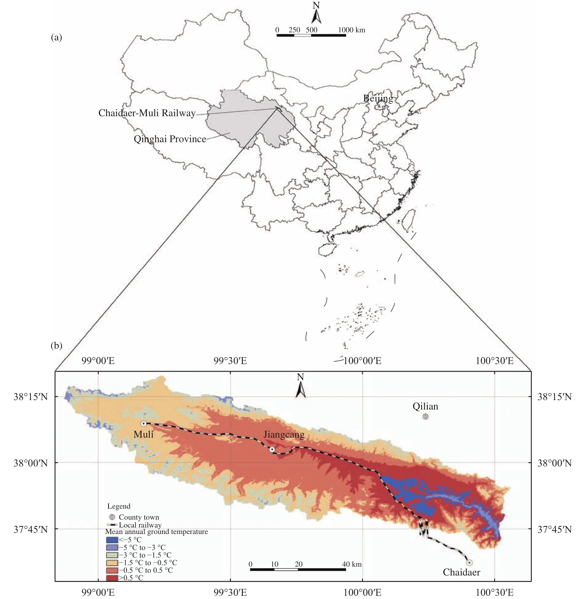
Figure 1 Location of the study area. (a) Map of China and Qinghai Province. (b) Permafrost zones along the Chadaer-Muli Railway according to mean annual ground temperatures
2.1 Integrated indicator system
Based on the aforementioned fuzzy-mathematics theory, this study evaluated the measure effect of rubble roadbed engineering in permafrost regions along the Chaidaer-Muli Railway. We first regarded the permafrost roadbed engineering as a system,where the evaluation object is the measure effect of this system. The evaluation system may include a number of subsystems, and the system or subsystem contains a series of influencing factors. Thus, the set of influence factor can be established based on the evaluation object. The set is expressed by the following formula:where n denotes the number of evaluation indicators.

Rubble roadbed engineering is an effective method of actively protecting permafrost during roadbed construction in permafrost regions. This protection is mainly due to the rubble layer which improves the cold storage capacity of the foundation under the embankment. There are numerous factors that influence the measure effect of rubble roadbed engineering due to complicated relationships between roadbed and the permafrost environment. These factors can be mainly classified as two categories, engineering geological conditions and roadbed engineering measures. Because of the particularity of the permafrost roadbed,permafrost characteristics will greatly impact the engineering effect of roadbed measure. Thus, permafrost characteristics should be independently considered as a class of indicators. Therefore, this study chooses the natural environment, permafrost characteristics and engineering measures as the main subsystems for the evaluation. Each subsystem includes a number of evaluation indicators. Then, a hierarchic system can be built to evaluate the measure effect of rubble roadbed engineering in permafrost regions along the Chaidaer-Muli Railway by using the basic principle of AHP method. This hierarchic system can be divided into three levels: (1) target layer: the effect of engineering measures; (2) criterion layer: natural environment, permafrost characteristics and engineering measures; (3) indicator layer: a number of specific indicators. In this way, the hierarchical structure,being composed of the target-criterion-indicator layer,can express the evaluation system of the measure effect of the roadbed engineering in permafrost regions.Figure 2 shows the evaluation system of the measure effect of rubble roadbed engineering in permafrost regions along the Chaidaer-Muli Railway.
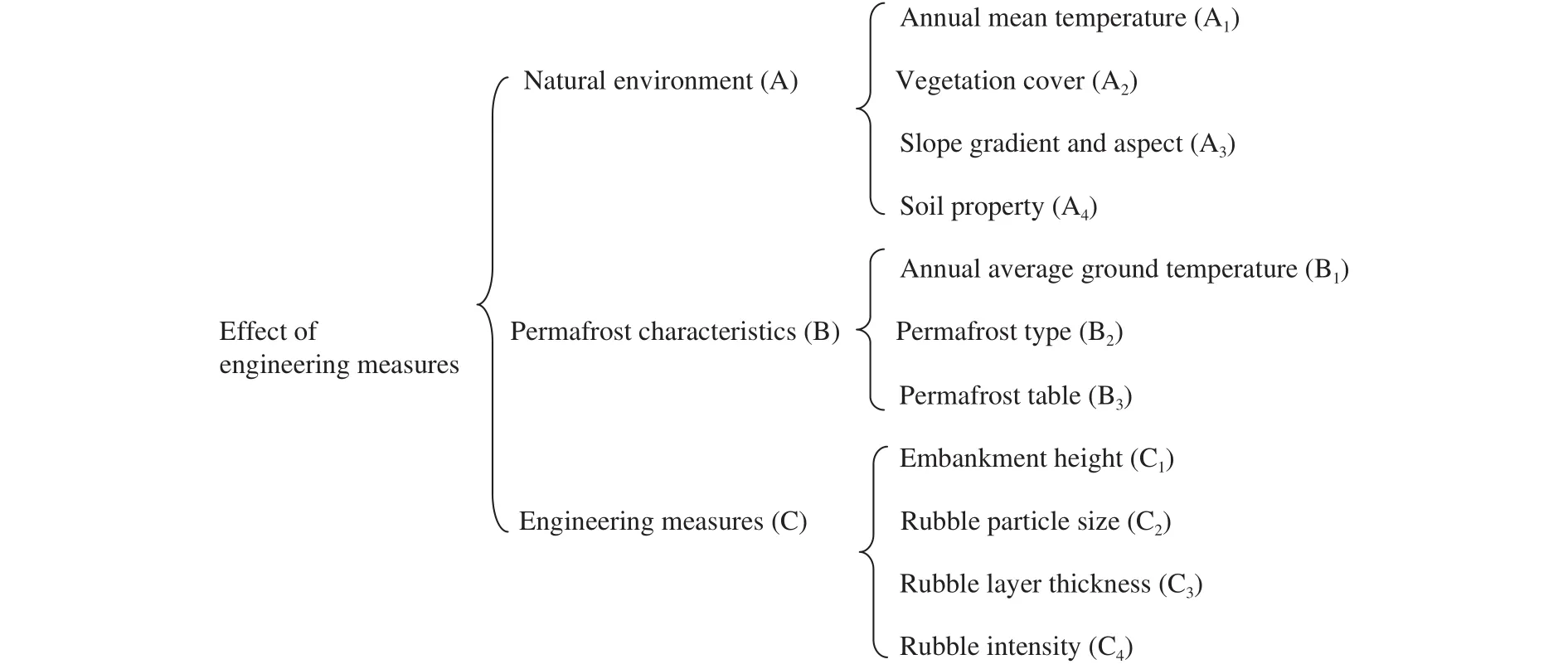
Figure 2 Evaluation system of the measure effect of the rubble roadbed engineering in permafrost regions along the Chaidaer-Muli Railway
(A) Natural environment
The natural environment is a decisive factor for permafrost formation with high ice content. Influencing factors mainly include topography, geological structure and hydrogeological conditions. There are four characteristic indices to represent the natural environment influencing the measure effect of rubble roadbed engineering in permafrost regions along the Chaidaer-Muli Railway. They are annual mean temperature, vegetation cover, slope gradient and aspect,and soil property.
Annual mean temperature is an important indicator influencing the natural environment in permafrost regions. In the Qinghai-Tibet Plateau, whether it is low-temperature or high-temperature permafrost regions, the permafrost table will decline with increasing temperature, or rise with declining temperature.
The overlaying vegetation is inevitably eradicated due to engineering activities. Once the alpine meadow is removed from the ground surface, permafrost will be directly exposed to the atmosphere. The surface temperature will thus rise, leading to increasing seasonal thawing depth, which will eventually result in the decline of the permafrost table. Vegetation cover thus is considered to be one indicator affecting permafrost thermal stability.
The slope gradient and aspect is another factor affecting permafrost thermal stability, which effects near-surface ground temperature. An increase in solar incident angle will lead to a gradual increase of surface absorption to solar radiation, which will eventually result in a gradual increase of near-surface temperature. The influence of slope aspect on ground temperature is more obvious, and causes asymmetry of the temperature field on both sides of the roadbed.
Soil property plays an important role in permafrost thermal stability. Soil property controls the deformation degree of permafrost roadbed due to different composition of mineral particles. Serious roadbed deformation mainly occurs in the railway section composed of fine particle soil, especially in soils rich in sub-clay and sub-sand. Thawing subsidence in this type of soil is caused by the existence of permafrost with high-ice content. The roadbed is relatively stable in sections composed of coarse particle soil, espe-cially in soils rich in gravel and rubble. In this geological condition, permafrost lacks high-ice content, and thawing subsidence rarely occurs.
(B) Permafrost characteristics
Permafrost characteristics are closely bound with the natural environment, with sub-surface factors producing frost heave and thawing settlement of the permafrost roadbed. Three major indicators are selected for permafrost characteristics, i.e., annual average ground temperature, permafrost type and permafrost table.
Annual average ground temperature shows the stable state of permafrost, e.g., permafrost with high temperature is extremely fragile. Marginal alteration due to climate change and human activity will cause a rapid rise of temperature and the thawing of permafrost with high temperatures. Once the permafrost conditions are the same, annual average ground temperature will control the deformation degree of the permafrost roadbed. The deformation degree of the permafrost roadbed will increase with increasing annual average ground temperature.
Permafrost type is a key factor for indicating permafrost characteristics. Moisture in the permafrost exists in the form of solid ice, where mineral particles in rock binds with ice. This process produces a great change of the rock-soil properties. The amount of ice content in permafrost determines the rising rate of temperature and the melting rate of permafrost. Thus,permafrost with high ice content will induce thermal melting and settlement deformation in the permafrost roadbed.
The permafrost table is considered as an evaluation indicator because roadbed deformation is closely related to the permafrost table. With a decrease of the permafrost table, roadbed deformation will increase.
(C) Engineering measures
Human activity is an external inducing factor to permafrost roadbed stability due to its thermal disturbance to the permafrost. Engineering measures help protect the thermal stability of permafrost roadbed. Therefore, it is an essential factor evaluating the measure effect of the rubble roadbed engineering in permafrost regions along linear engineering. Four major indicators are selected for engineering measures.They include embankment height, rubble particle size,rubble layer thickness and rubble intensity.
Increasing the embankment height is a passive measure of permafrost protection. Once this measure is taken in permafrost regions, it can control the decline of the permafrost table and even raise the permafrost table to a certain extent. Therefore, embankment height is selected as an indicator influencing the permafrost thermal stability.
Rubble roadbed engineering is an active measure of permafrost protection, mainly used to cool the temperature of the soil body by air convection. The core issue is how to determine the best aperture to allow the cold air to easily go in but difficult to go out of the rubble. If the aperture is too large, the cold air will easily go in and out, and the cooling effect will depend on the ventilation quantity. At the same time,temperature in the rubble layer must be higher than ambient temperature. Conversely, if the aperture is too small, the cold air will be difficult to go in and out, resulting in little cooling effect in the rubble layer. Rubble particle size is thus considered as an influencing factor due to its importance.
Railway operation has a vibration load imposed on the rubble roadbed, which cannot be allowed to change the structure and property of the rubble and the cooling effect. Vibration loads and other external forces can change the shape, size and intensity of the rubble to a certain extent. Thus, a thick layer of rubble can help prevent the destruction of the rubble layer structure, and the cooling effect of rubble roadbed will be more durable. If the rubble layer is very thin,the layer will easily break under the vibration load,producing almost no cooling effect in the rubble layer.Therefore, we select rubble layer thickness as an evaluation indicator.
Due to the existence of strong weathering in the Qinghai-Tibet Plateau, the greater the rubble intensity is, the stronger the anti-weathering ability is. Thus,the damage of rubble roadbed will be smaller, and the cooling function will be more durable. In contrast, the smaller the rubble intensity is, the worse the weathering ability is. Thus, the function of rubble roadbed and the cooling effect will become worse. Rubble intensity is thus another factor selected as an evaluation indicator. Rubble intensity mentioned here refers to the compressive ultimate strength in the saturated uniaxial state of a fresh rock mass.
2.2 Evaluation criteria
In section 2.1, we have established the evaluation system of the measure effect of rubble roadbed engineering in permafrost regions along the Chaidaer-Muli Railway. According to the fuzzy-mathematics theory,the evaluation criteria must be established because the evaluation result needs to be considered as a reference point. Thus, the evaluation setis determined as the classification standards, where m denotes the number of classification. In this study, the evaluation set is divided into four grades, which include good (a), preferable (b), general (c), and poor state (d).
Although the establishment of evaluation criteria is necessary, so far a referenced standard for the effect evaluation indicators of permafrost roadbed is not available. This study establishes the evaluation criteria by using the standard proposed by the previous study (Lai et al., 2003; Xu et al., 2004; Wu et al.,2005b; Ma et al., 2006; Cao et al., 2009), especially referencing actual conditions of the permafrost rubble roadbed in the Qinghai-Tibet Plateau. Classification standards were divided by the principles as follows:code for engineering geological investigation in permafrost regions, scientific research results in roadbed engineering along the Qinghai-Tibet railway, data analysis results and expert's consultation. This standard for evaluation criteria is presented in Table 1.

Table 1 Classification criterion of effecting evaluation of rubble roadbed engineering in permafrost regions
2.3 Single-factor evaluation
Once the evaluation factor-set and criteria-set are determined, the single-factor evaluation should be conducted to highlight the role of each influencing factor in the system. Thus, we establish the singlefactor evaluation matrix R according to the fuzzymathematics theory. The fuzzy theory mainly makes the single-factor evaluation on each factor in the influencing factor-setby the use of the appropriate membership function. The result of single-factor evaluation is a fuzzy subset of the evaluation set. If there is a factor i, its single-factor evaluation set will be expressed as the following formula:

Therefore, the single-factor evaluation matrix R is denoted as follows:
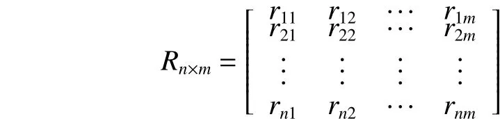
where n refers to the number of the evaluation index,n=11; m is the number of the evaluation criteria, m=4;rnmis the value of single-factor evaluation being determined according to the membership function.The use of the membership function will follow the following principles in the fuzzy-mathematics theory.
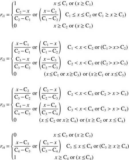
If the evaluation factor is quantitative, the membership function will generally take the lifting semitrapezoidal function and the linear triangle function.The function is shown as follows:
Certain evaluation indices can only be described qualitatively due to the complexity of evaluation factors. Therefore, their membership functions are not continuously variable. This study transforms the membership function into a group of more suitable numerical values with a feature of normal distribution. We determine the values of the membership degree of the single-factor evaluation by consulting with experts in the related field. They specialize in permafrost research, engineering geology, railway construction, and evaluation management. The values of membership function are presented in Table 2.
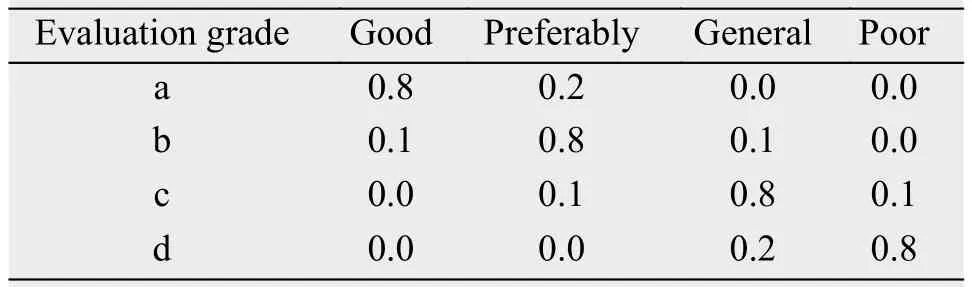
Table 2 Membership degree of the single-factor evaluation
2.4 Evaluation indicator weight
Although the single-factor evaluation was made in the above section, the role of each evaluation factor is different in the system. Thus, we determine the different weight of each factor. In the fuzzy-mathematics theory, the weight set is defined as

where n denotes the number of evaluation indicators.
In this study, the weight of each indicator is determined by using the Analytic Hierarchy Process(AHP) method. According to the AHP method, about 30 experts from different fields are consulted to fill the questionnaires twice. These experts specialize in the fields of permafrost engineering, engineering construction and management. The judgment matrixes are respectively established based on the comprehensive views from the filled questionnaires (Tables 3-6). In these questionnaires, the importance of two factors is expressed according to a 1-9 comparison-scaling method introduced by T.L. Saaty. The judgement matrix A can be established according to the factors'importance:whereis the reference number 1-9 or its reciprocal. The weight of each indicator is calculated by the root method. The product of every row element of the judgement matrix should be firstly calculated:. Then,the n-th root of the productcan be also calculated:Afterthat, the vectorsshould be normalized:. Th en, the eigenvector can be expressed as. The largest eigenvalueshould be also computed, whereis the istcomponent of the vector AW. Finally, we should apply a consistency check of the judgement matrix:where RI is the average random consistency index listed by the literature.If the inequalityis established, the judgement matrix will satisfy the consistency. If not, it is necessary to adjust the judgement matrix until satisfactory. The matrixes matrices include the measure effect, natural environment, permafrost characteristic and engineering measure. Each indicator's weight is obtained by use of the AHP algorithm (Xu, 2002;Chen et al., 2006a), listed in Tables 3-6, respectively.
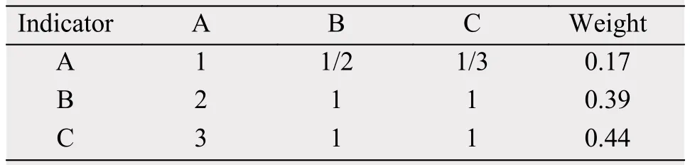
Table 3 Weight of evaluation indicator for the measure effect of rubble roadbed engineering
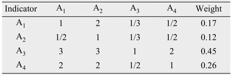
Table 4 Weight of evaluation indicator for the natural environment
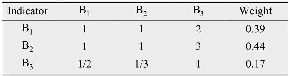
Table 5 Weight of evaluation indicator for the permafrost characteristic
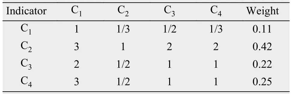
Table 6 Weight of evaluation indicator for the engineering measure
2.5 Fuzzy comprehensive evaluation
Based on the single-factor evaluation matrix R and the weight set A, the result of fuzzy comprehensive evaluation can be calculated according to the following formula:
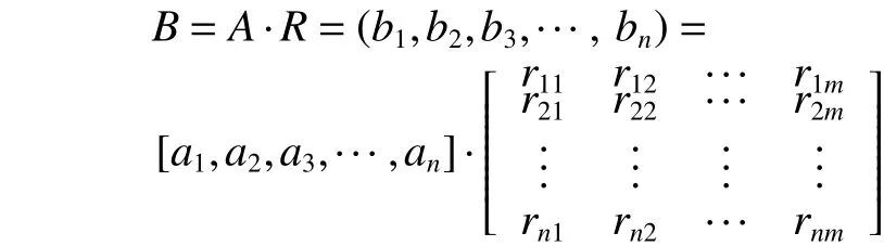
where birefers to the membership degree of an evaluation unit to the i evaluation grade.
3 Results and discussion
This paper evaluates the measure effect of rubble roadbed engineering in permafrost regions along the Chaidaer-Muli Railway by using the aforementioned method of fuzzy comprehensive evaluation. The evaluation results are presented in Table 7.
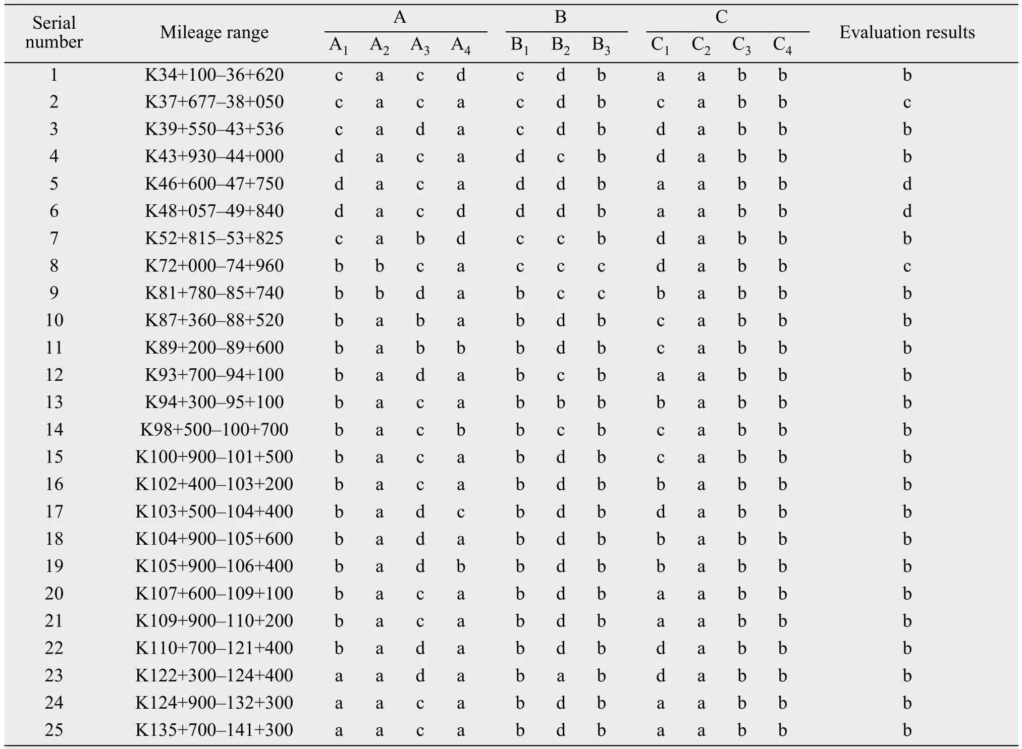
Table 7 Evaluation results of the measure effect of rubble roadbed engineering in permafrost regions along Chaidaer-Muli Railway
Figure 3 shows the statistic analysis results of the measure effect evaluation of rubble roadbed engineering in permafrost regions along the Chaidaer-Muli Railway. It can be seen from Figure 3 that most of the permafrost roadbed is in a preferable condition (b)along the Chaidaer-Muli Railway due to the rubble engineering measure. This proportion reaches to 86.1%. The proportion in general state (c) and poor state (d) is 7.5% and 6.4%, respectively. A good state(a) is lacking in all the evaluation sections along the Chaidaer-Muli Railway. The evaluation result shows that most of the permafrost roadbed stability is in good state due to the rubble engineering measure.Thus, the rubble engineering measure is remarkable for actively protecting permafrost roadbed stability. In addition, many railway sections have also used other treatment measures for actively protecting permafrost roadbed stability. These measures include soil replacement and silt squeezing. Certain railway sections have used the composite measure of thermalpipe roadbed and rubble-stone roadbed. All these measures and methods improve permafrost roadbed stability to a certain extent. Therefore, the actual effect of engineering measures will be better than the evaluation results.
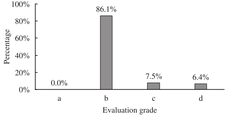
Figure 3 Evaluation grading results of the measure effect of rubble roadbed engineering in permafrost regions along Chaidaer-Muli Railway (a: good state; b: preferable state; c: general state; d: poor state)
On the other hand, it can be seen from Figure 4 that the main factors influencing the engineering effect of rubble roadbed in permafrost regions are rubble particle size (C2), permafrost type (B2) and annual average ground temperature (B1). The weights of these main factors are 0.185, 0.172, 0.152, respectively. Secondary factors are rubble intensity (C4),rubble layer thickness (C3), slope gradient and aspect(A3) and permafrost table (B3). Their weights reach to 0.110, 0.097, 0.077, 0.066, respectively. The other factors mildly influence the engineering effect of rubble roadbed in permafrost regions along the Chaidaer-Muli Railway. All weights of these factors are below 0.050. As presented in Table 7, the comprehensive evaluation results of certain railway sections are in general state (c) and poor state (d). These sections include K37+677-38+050, K46+600-47+750,K48+057-49+840 and K72+000-74+960. Table 7 shows that the rubble particle size in these four sections is in good state (a). The other two important factors are in general state (c) and poor state (d), including permafrost type and annual average ground temperature. These two factors may influence the final evaluation result to a large extent. Therefore, it is clear that sections with poor roadbed stability are basically located in regions with high temperature and high ice-content permafrost.

Figure 4 Weight of evaluation indicator for the measure effect of the rubble roadbed engineering in permafrost regions along Chaidaer-Muli Railway (A1: annual mean temperature;A2: vegetation cover; A3: slope gradient and aspect; A4: soil property; B1: annual average ground temperature; B2:permafrost type; B3: permafrost table; C1: embankment height; C2: rubble particle size; C3: rubble layer thickness; C4: rubble intensity)
It is a fact that deformation will determine roadbed stability in permafrost regions. Once the permafrost roadbed undergoes a deformation due to the rise of below ground temperature, cracks will mainly appear on the top and sides of the railway roadbed.Therefore, the change of ground temperature field will affect the deformation of permafrost roadbed. In addition, roadbed deformation is closely related to the permafrost table. With the rising of the permafrost table, roadbed deformation will decrease. The deformation crack is morphologically divided into longitudinal and transverse cracks. Due to asymmetry of the temperature field, it is very likely to be subjected to longitudinal cracks. Thus, we selected four actual monitoring indices to evaluate the measure effect of rubble roadbed engineering in permafrost regions along the Chaidaer-Muli Railway. These indices include raising range of permafrost table, descending range of ground temperature, symmetry of the temperature field, and deformation range of the roadbed,respectively. These indices can better monitor the effect of engineering measures and effectively test the evaluation result. The classification standards for monitoring indices were divided according to field observation data and relevant scientific literature. This classification standard for effecting characteristic is presented in Table 8.

Table 8 Classification for effecting characteristic of rubble roadbed engineering in permafrost regions
In order to monitor the change of permafrost, test sections were established along the Chadaer-Muli Railway as a complementary means of the evaluation of roadbed stability. The observation data of ground temperature are obtained from monitoring holes in order to verify the fuzzy evaluation result. These monitoring holes of the rubble roadbed are mainly placed in five test sections along the Chadaer-Muli Railway.These sections include DK39+800, DK40+000,DK74+000, DK123+150, and DK123+250. Data of roadbed deformation are also obtained by the field survey. Table 9 compares the fuzzy evaluation value and the actual monitoring value of the measure effect of the rubble roadbed engineering in permafrost regions along the test sections. As can be seen from Table 9, the actual monitoring results are basically consistent with the model evaluation results. This means that the fuzzy evaluation method can be applied to evaluate the effect of rubble roadbed engineering measures in permafrost regions.
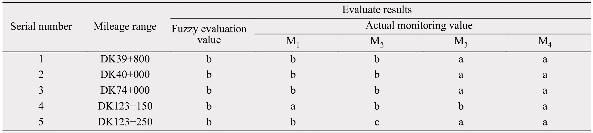
Table 9 Effecting evaluation of rubble experimentation roadbed engineering in permafrost regions of Chaidaer-Muli Railway
4 Conclusions
(1) In this paper, the AHP-FUZZY method is introduced to evaluate the measure effect of rubble roadbed engineering in permafrost regions along the Chadaer-Muli Railway. The results show that most of the permafrost roadbed is in a preferable condition (b)along the Chaidaer-Muli Railway due to the rubble engineering measure. This proportion reaches to 86.1%. The proportion in general state (c) and poor state (d) is 7.5% and 6.4%, respectively. The good state (a) is lacking in all the evaluation sections along the Chaidaer-Muli Railway. Ground-temperature monitoring results are generally consistent with the AHP-FUZZY evaluation results. This means that the AHP-FUZZY evaluation method can be applied to evaluate the effect of rubble roadbed engineering measures in permafrost regions.
(2) There are numerous factors influencing the measure effect of rubble roadbed engineering in permafrost regions. The selection of evaluation indices will have a great impact on the evaluation result.
Therefore, the establishment of the evaluation index system needs optimization and improvement with the improvement of cognition. Furthermore, the accuracy of evaluation result depends on the reliability of data sources of the evaluation indicators. There is subjectivity in calculating the weights of evaluation index and establishing the membership function of the single factor evaluation to a certain degree. And the weights will have a great impact on the evaluation result, and needs to be improved in future research.
Acknowledgments:
This work was supported by the National Natural Science Foundation of China (Nos. 41501079 and 91647103), the self-determined Project Funded by State Key Laboratory of Frozen Soil Engineering (No.SKLFSE-ZQ-43), the Foundation for Excellent Youth Scholars of NIEER, CAS.
 Sciences in Cold and Arid Regions2018年6期
- Sciences in Cold and Arid Regions的其它文章
- Stable isotopes reveal varying water sources of Caragana microphylla in a desert-oasis ecotone near the Badain Jaran Desert
- Simulation and prediction of monthly accumulated runoff,based on several neural network models under poor data availability
- Contrasting vegetation changes in dry and humid regions of the Tibetan Plateau over recent decades
- Local meteorology in a northern Himalayan valley near Mount Everest and its response to seasonal transitions
- Fossil Taiwannia from the Lower Cretaceous Yixian Formation of western Liaoning, Northeast China and its phytogeography significance
- Academic Workshop of China Society of Desert in the Geographical Society of China successfully held in Changsha, Hunan Province