
Susceptibility assessment of debris fows using the analytic hierarchy process method-A case study in Subao river valley,China
2015-02-09 01:28XingzhngChenHuiChenYongYouJinfengLiu
Xingzhng Chen,Hui Chen,Yong You,Jinfeng Liu
aSchool of Environment and Resource,Southwest University of Science and Technology,Mianyang 621010,China
bInstitute of Mountain Hazards and Environment,Chinese Academy of Sciences,Chengdu 610041,China
Susceptibility assessment of debris fows using the analytic hierarchy process method-A case study in Subao river valley,China
Xingzhang Chena,*,Hui Chena,Yong Youb,Jinfeng Liub
aSchool of Environment and Resource,Southwest University of Science and Technology,Mianyang 621010,China
bInstitute of Mountain Hazards and Environment,Chinese Academy of Sciences,Chengdu 610041,China
A R T I C L EI N F O
Article history:
Received 16 December 2014
Received in revised form
15 April 2015
Accepted 18 April 2015
Available online 3 June 2015
Debris fows
Susceptibility assessment
Geographic information system(GIS)
Analytic hierarchy process(AHP)method
Wenchuan earthquake
Subao river valley
Many debris fows have occurred in the areas surrounding the epicenter of the Wenchuan earthquake. Susceptibility assessment of debris fows in this area is especially important for disaster prevention and mitigation.This paper studies one of the worst hit areas,the Subao river valley,and the susceptibility assessment of debris fows is performed based on feld surveys and remote sensing interpretation.By investigating the formation conditions of debris fows in the valley,the following assessment factors are selected:mixture density of landslides and rock avalanches,distance to the seismogenic fault,stratum lithology,ground roughness,and hillside angle.The weights of the assessment factors are determined by the analytic hierarchy process(AHP)method.Each of the assessment factors is further divided into fve grades.Then,the assessment model is built using the multifactor superposition method to assess the debris fow susceptibility.Based on the assessment results,the Subao river valley is divided into three areas:high susceptibility areas,medium susceptibility areas,and low susceptibility areas.The high susceptibility areas are concentrated in the middle of the valley,accounting for 17.6%of the valley area. The medium susceptibility areas are in the middle and lower reaches,most of which are located on both sides of the high susceptibility areas and account for 45.3%of the valley area.The remainders are classifed as low susceptibility areas.The results of the model are in accordance with the actual debris fow events that occurred after the earthquake in the valley,confrming that the proposed model is capable of assessing the debris fow susceptibility.The results can also provide guidance for reconstruction planning and debris fow prevention in the Subao river valley.
©2015 Institute of Rock and Soil Mechanics,Chinese Academy of Sciences.Production and hosting by Elsevier B.V.All rights reserved.
1.Introduction
The Wenchuan earthquake,which occurred on 12 May 2008, caused more than 15,000 geohazards,the majority of which were rock avalanches and landslides(Huang and Li,2008).Such landslides and avalanches provide a considerable amount of loose materials for debris fows,which are expected to be more frequent and in the active period of the next 20-30 years(Cui et al.,2011). Thus,the susceptibility assessment of debris fows is of great signifcance to disaster prevention and mitigation in earthquakeprone areas.
Assessment factors and methods are vital to assessing the debris fow susceptibility.Li et al.(2006,2009a)demonstrated that the events of debris fow correlate with particular stages of the basin evolution.The rock hardness determines the ability to provide loose materials and then infuences the occurrence frequency of debris fows(Lu et al.,2011).Zhang et al.(2008)ranked the common rocks based on their susceptibility to debris fow in ascending sequence,i.e.basalt,argillaceous limestone,dolomite,slate,Quaternary deposit,sandstone,siltstone,phyllite,and mudstone.Tang and Liang(2008)argued that phyllite and slate were especially prone to forming debris fows in the Beichuan earthquake area. With regard to the assessment method,based on a conditional probability model,Tang(2005)and Zou et al.(2012)analyzed the spatial susceptibility of debris fow in the Nujiang River basin of Yunnan and the Upper Yangtze River basin,respectively.Carrara et al.(2008)developed and compared fve models(statistical approach vs.physically based approach)for predicting the debris fow occurrence in an alpine area.They found that all of the statistical models were reliable and robust,while the physically based model had low predictive power.Then,Luca et al.(2011)presented an evolution of gullying susceptibility using bivariate and multivariate statistical models,and found the latter had more predictive power in gullying susceptibility.After the Wenchuan earthquake, many researches were also conducted on the susceptibility andactivities of debris fow in earthquake areas(Liu et al.,2009;Tang et al.,2012;Wang et al.,2013;Liu et al.,2014).
The Subao river valley is located in the worst hit area of the Wenchuan earthquake.The Beichuan reverse fault,considered as the seismogenic fault(Burchfel et al.,2008;Li et al.,2008,2009b; Xu et al.,2008),passes through the valley.The earthquake induced many landslides and rock avalanches.On 24 September 2008,a rainstorm triggered a group of large debris fows in the valley, causing 11 deaths and signifcant damages(Tang and Liang,2008; Tang et al.,2009;You et al.,2010).After that,several debris fows occurred every year in the valley,seriously threatening the postdisaster reconstruction.The valley has become one of the highest susceptibility areas of debris fow.
This paper describes the formation conditions of debris fows in the Subao river valley,based on feld surveys and remote sensing images.Then,we build a model based on the ArcGIS platform to assess the debris fow susceptibility in the valley area.
2.Study area
2.1.Valley overview
The Subao river valley is located to the west of Leigu town, approximately 8 km south of Beichuan county(Fig.1).The valley covers an area of 72.2 km2,and the river is 16.5 km long.The river, in the middle of the catchment area,fows from west to east.In the valley,the highest point is 2312 m and the relative relief is 1597 m, with a mean relief ratio of 9.28%.The channel is mainly U-shaped, with a width varying from a few meters to several tens of meters.
2.2.Topography
Mountains dominate the Subao river valley,which is in the transition area between the front and back of the Longmen Mountains.The valley head is approximately 2312 m wide,falling rapidly to 715 m at the valley mouth.The main channel has a steep gradient with a mean relief ratio of 9.28%.The valley is dominated by steep slopes(Fig.1).The slope angles are greater than 25°,with some up to 40°-50°or more.The area of steep(25°-35°)and steeper(>35°)slopes is 46.76 km2,accounting for up to 64.76%of total slope area.Table 1 lists the slope statistic data of the Subao river valley acquired from 1:50000 digital elevation model(DEM).
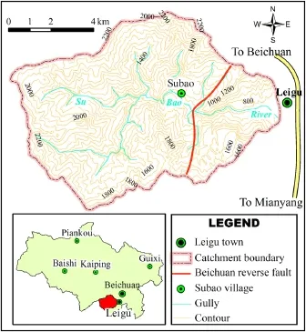
Fig.1.The location and topographic features of the Subao river valley.
2.3.Geological settings
Fig.2 shows the Beichuan reverse fault passing through the Subao river valley.The strike of the fault plane is almost northeast in direction(Dong et al.,2006).The motion of this fault is responsible for the uplift of the mountains relative to the lowlands of Sichuan Basin to the east.
The stratum lithology is controlled by the Beichuan reverse fault. The hanging wall in the northwest is mainly composed of Silurian metamorphic rocks,which originated from regional metamorphism with a foliated texture and numerous cracks.The metamorphic rocks,distributed in the middle and upper catchment areas,are composed of phyllite,slate,sandstone,and other similar rocks.The footwall in the southeast is mainly composed of shallow sea phase sedimentary rocks of the middle Devonian period,including limestone,argillaceouslimestone,bioclasticlimestone,andsiltstone.The footwall also contains a small amount of Cambrian siltstone.The rocks of the footwall disperse farther downstream,where there are steep slopes with hard rocks that are resistant to erosion.
According to feld surveys and remote sensing images(with a resolution of 0.5 m),it is determined that the Wenchuan earthquake directly induced more than 300 landslides and rock avalanches in the Subao river valley(Fig.2).Landslides mainly developed in softer rock areas(such as the hanging wall)and rock avalanches mainly occurred in hard rock areas(such as the footwall).These geohazards continue to provide enough loose materials for subsequent debris fows and will last for several decades.
2.4.Climate
The Subao river valley has a mild subtropical humid monsoon climate with four distinct seasons and an average annual temperature of 15.6°C.The valley has rich rainfalls with an average annual precipitation of 1399.1 mm.The 24-h maximum precipitation was 101 mm,and the 1-h maximum precipitation was 42 mm. Approximately 80%of the rain falls between June and September. Rainstorms,combined with topographic effects,can result in debris fows in the rainy season.
3.Assessment factors
The determination of assessment factors should consider the debris fow formation conditions in the valley.Generally,the formation conditions of debris fow include loose materials,topography and precipitation.
3.1.Loose materials
Loose deposits form an important material basis of debris fow events.Generally,the loose materials are determined by the stratum lithology and geological structures.
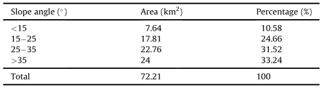
Table 1Slope statistic data of the Subao river valley.

Fig.2.Geological map and geohazards distribution of the Subao river.
The stratum lithology controls the ability to form loose materials,and affects the formation of debris fows.Tang and Liang (2008)studied the relationship between debris fows and rock types after the Wenchuan earthquake in Beichuan County.They found that the debris fow formation is sensitive to rock types,and the sensitivity from high to low is Silurian phyllite,Cambrian siltstone,and Devonian and Carboniferous limestones.
Geological structures,especially the Beichuan reverse fault,have an important effect on producing loose materials.During the Wenchuan earthquake,more loose materials were formed close to the Beichuan reverse fault.Therefore,the stratum lithology and the distance to the Beichuan reverse fault should be considered as two important assessment factors.
Landslides and rock avalanches are important transportation ways for loose materials.The landslides and rock avalanches, induced by the Wenchuan earthquake,are of great signifcance for debris fow formation.These geohazards can supply the debris fows with enough loose materials,which should be considered as an important assessment factor.The geohazards density can represent the loose materials distribution.Based on the 300 geohazards interpreted from a remote sensing image(with a resolution of 0.5 m),we can obtain the geohazards density of the Subao river valley using the kernel density tool in ArcGIS9.3.
Therefore,three assessment factors for loose materials are selected,i.e.density of landslides and rock avalanches,distance to the seismogenic fault,and stratum lithology.
3.2.Topography
The topography has a direct impact on debris fow formation through its infuence on confux process.Steeper slopes result in a faster speed of fow;both slopes below and above ground surface are prone to form debris fows.It is accepted that slopes steeper than 25°can provide loose materials for debris fows and are conducive to affuxion.In the valley,approximately 64.76%of the total area contains steep slopes(>25°)and is therefore prone to form debris fows.The hillside angle should be considered as an important assessment factor.
In addition to the hillside angle,ground roughness also affects the formation of debris fows.The ground roughness denotes the ratio of surface area tothe projective areafor a given area.It directly affects the ability of ground confuence and seepage.As one of the topographic factors,the ground roughness of the valley should be considered as an assessment factor.Based on the DEM data,the values of ground roughness in the Subao river valley can be obtained using surface analysis tools in ArcGIS9.3(Fig.3d).
3.3.Precipitation
Rainfall,a triggering factor of debris fows,is signifcant to the formation of debris fows.In the rainy season,rainstorms can directly induce debris fows in the Subao river valley due to the effects of the Wenchuan earthquake.However,the valley only covers an area of 72.2 km2,and the rainfall has no obvious difference in the whole valley.Therefore,the rainfall is very important for debris fow formation,but it is just a background condition and not suitable to be an assessment factor.
According to the above analysis,we select fve assessment factors.Based on their contribution to debris fow formation,they are density of landslides and rock avalanches(x1),distance to the seismogenic fault(x2),stratum lithology(x3),ground roughness (x4),and hillside angle(x5).Each of them is divided into fve grades, as shown in Fig.3.
4.Assessment method
The selected factors are diverse sources of information and diffcult to compare to each other.To integrate them into a consistent system for assessment,we defne numerical weights of all factors with the analytic hierarchy process(AHP)method.One of the most prominent features of the AHP method is its ability to evaluate quantitative as well as qualitative criteria and alternatives on the same preference scale.The method is widely used in hazard evaluation,including natural hazard assessment(Nefeslioglu et al., 2013),landslide susceptibility evaluation and mapping(Komac, 2006;Nandi and Shakoor,2009;Kayastha et al.,2013;Shahabi et al.,2014),debris fow risk degree assessment(Yang et al., 2011),single debris fow risk assessment(Tie and Tang,2006), and decisions for regional debris fow prevention(Ma et al.,2009). In this paper,we weight the assessment factors using the AHP method.
The AHP method,pioneered by Saaty in the 1970s,is a structured technique for organizing and analyzing complex decisions based on mathematics and psychology.It is used around the world in a wide variety of decision situations(Vaidya and Kumar,2006; Saaty,2008).A detailed description of the AHP method is available in Saaty(1980).The procedure for using the method can be summarized as follows(Saaty,2008):
(1)Defne the problem and determine the type of knowledge sought.
(2)Structure the decision hierarchy from the top,with the goal being the decision,and the objectives branching down through the intermediate levels to the lowest level.
(3)Construct a set of pairwise comparison matrices.Each element in an upper level is compared with the elements in the level immediately below it.
(4)Check the consistency of the judgments.The consistency ratio (CR)should be calculated for consistency with the evaluation matrix and the value of theCRshould be no higher than 0.1.
(5)Use the priorities obtained from the comparisons to weigh the priorities in the level immediately below.Do this for every element.Then,for each element in the level below,add its weighted values and obtain its overall or global priority.
The pairwise comparison employs an underlying nine-point recording scale to rate the relative preference on a one-to-onebasis of each factor.Table 2 shows a linguistic expression to each corresponding numerical value(Kamp et al.,2008).
There are many regional evaluation methods,such as the grey correlation method,the fuzzy comprehensive evaluation method,and the weighted average method.According to the existing research results,the multifactor superposition method is a popular,simple and effective one(Liang et al.,2011;Li et al., 2012),and its calculation method is simple and clear.The calculation result is a summation of the products of factor weight and factor score.The factor weights are determined by the AHP method.The calculation method is expressed as follows:
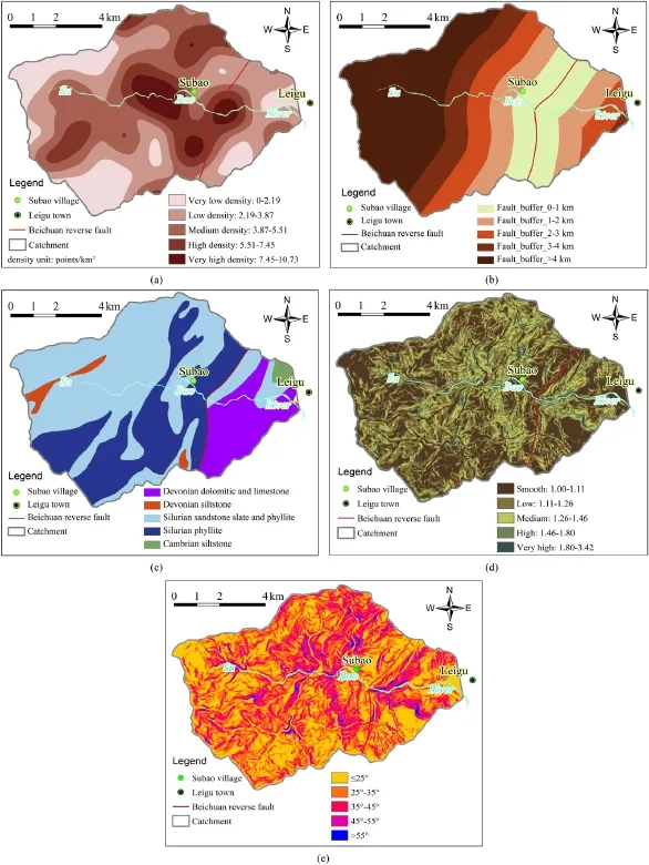
Fig.3.Figures of the fve assessment factors,each of them divided into fve grades.(a)Density of landslides and rock avalanches,(b)Distance to the seismogenic fault,(c)Stratum lithology,(d)Ground roughness,and(e)Hillside angle.

whereYdenotes the summation of the products of factor weightaiand factor scorexi.
5.Factors system and assessment model
5.1.Factors system
The weights for each factor are calculated by a pairwise comparison matrix.The quality of the comparison is described by theCR,which is a ratio between the matrix’s consistency index(CI)and random index(RI).ACRvalue below 0.1 indicates that the comparison matrix is consistent.
The pairwise comparison matrix and factor weights are shown inTable 3.The density of landslides and rock avalanches is the most heavily weighted factor,followed by distance to seismogenic fault and stratum lithology.Hillside angle is the least infuential parameter,while ground roughness had even less infuence.The results verify the view that density of geohazards and distance to seismogenic fault are the most infuential event-controlling parameters for debris fows in the Wenchuan earthquake area.
The consistency ratio(CR)of the judgment matrix is0.04,farless than 0.1,which means the consistency of the judgments is very good.The scores for each grade and the weights of the factors are determined by the AHP method,as shown in Table 4.The value is the product of factor weight and score.

Table 2Pairwise comparison nine-point rating scale.
5.2.Assessment model
Using Eq.(1)and data of Table 4,we build a susceptibility assessment model of debris fows in the study area as follows:

where the subscriptiis the grid number calculated by ArcGIS.
The fnal assessment is based on the spatial analysis of ArcGIS platform.First,the basic data of the study area are converted to raster images of each factor using the spatial analyst tool in Arc-GIS9.3.Next,the images are reclassifed and assigned the corresponding value of each grade using the reclassify tool.Finally,using the above assessment model,the results are acquired by the raster calculator function of the spatial analyst tool.
6.Assessment results
The assessment results are plotted in a susceptibility-zoning map of debris fow occurrence,which is divided into three classes using the natural breaks(Jenks)method.The natural breaks(Jenks) method,also called the Jenks optimization method,is a data clustering method designed to determine the best arrangement of values into different classes.The method seeks to reduce the variance within classes and maximize the variance between classes to determine the best arrangement of values into different classes.
Fig.4 shows the susceptibility assessment results of debris fows in the Subao river valley.The high susceptibility areas concentrate in the middle of the valley,accounting for 17.6%of the valley area, most of which are on the hanging wall of Beichuan reverse fault. The medium susceptibility areas are in the middle and lower reaches and some in the upper reaches,most of which are located on both sides of high susceptibility areas,accounting for 45.3%of the valley area(Table 5).The remainders belong to low susceptibility areas.
The Wenchuan earthquake induced several geohazards in the valley,which provided a considerable amount of loose materials for the subsequent debris fows.Because of the rapid and substantial addition of loose materials,debris fows are much greater and more frequent in the valley.Fig.4 shows the debris fowcatchments(blue points)and non-debris fow catchments(white points)in the Subao river valley.

Table 3Pairwise comparison matrix for calculating factor weights.

Table 4Assessment factor system of debris fow susceptibility.

Fig.4.Assessment results of debris fow susceptibility and debris fows occurred after the Wenchuan earthquake in the Subao river valley.

Table 5Statistic results of debris fow susceptibility in the Subao river valley.
Table 5 lists the statistic assessment results of the debris fow susceptibility in the Subao river valley.The ratio of debris fow catchment area in the susceptibility area to the susceptibility area (RDASA)of high susceptibility areas is 70.1%,which means most of the high susceptibility areas formed debris fows.The RDASAs of medium and low susceptibility areas are 53.5%and 21.3%,respectively.The RDASA of low susceptibility areas does not mean that these areas must have formed debris fows because debris fow does not necessarily occur in the whole basin.On the contrary, regardless of whether part of a catchment is in a low susceptibility area or not,the possibility of forming debris fows will increase greatly if all or part of the catchment lies in a high susceptibility area.Fig.4 and Table 5 show that the debris fow catchments are mainly concentrated in the high and medium susceptibility areas. The assessment results are in accordance with the debris fows that occurred following the 2008 Wenchuan earthquake in the valley.
7.Conclusions
The Subao river valley is one of the highest potential occurrence areas of debris fows in the Wenchuan earthquake area.We select fve assessment factors,i.e.density of landslides and rock avalanches,distance to the seismogenic fault,stratum lithology, ground roughness,and hillside angle,and weight the factors using the AHP method.On this basis,the susceptibility assessment model of debris fows in the valley is built using the multifactor superposition method.
The fnal assessment is based on spatial analysis of ArcGIS platform using the built model.The assessment results are plotted in a susceptibility-zoning map of debris fow occurrence,which is divided into high susceptibility areas,medium susceptibility areas, and low susceptibility areas using the natural breaks(Jenks) method.The high susceptibility areas concentrate in the middle of the valley.The medium susceptibility areas are in the middle and lower reaches,most of which are located on both sides of the high susceptibility areas.The medium and high susceptibility areas account for 17.6%and 45.3%of the Subao river valley area,respectively.The remainders belong to low susceptibility areas.
The assessment results are in accordance with the actual debris fows that occurred after the Wenchuan earthquake in the valley. The results also demonstrate that the method can be used to assess the debris fow susceptibility in an earthquake-prone area.
It is suggested that,in the high susceptibility areas,human activities should avoid debris fows and should not carry out control projects against debris fows in the short term.In the medium susceptibility areas,it is suggested that human activities should try to avoid debris fows and engineering control standards should be implemented if necessary.Debris fow assessment must also be conducted in the low susceptibility areas to ensure no threat of debris fows to human activities.
Confict of interest
The authors wish to confrm that there are no known conficts of interest associated with this publication and there has been no signifcant fnancial support for this work that could have infuenced its outcome.
Acknowledgments
It is gratefully noted that the project is supported by the National Natural Science Foundation of China(Grant No.41372301) and the National Science and Technology Support Program(Grant No.2012BAC06B02).We are also grateful to two anonymous reviewers for their advices and contributions to this paper.
Burchfel BC,Royden LH,van der Hilst RD,Hager BH,Chen Z,King RW,Li C,Lu J, Yao H,Kirby E.A geological and geophysical context for the Wenchuan earthquake of 12 May 2008,Sichuan,People’s Republic of China.GSA Today 2008;18(7):4-11.
Carrara A,Crosta G,Frattini P.Comparing models of debris-fow susceptibility in the alpine environment.Geomorphology 2008;94:353-78.
Cui P,Chen XQ,Zhu YY,Su FH,Wei FQ,Han YS,Liu HJ,Zhuang JQ.The Wenchuan earthquake(May 12,2008),Sichuan province,China,and resulting geohazards. Natural Hazards 2011;56(1):19-36.
Dong J,Wei GQ,Chen ZX,Li BL,Zeng Q,Yang G.Longmen Shan fold-thrust belt and its relation to the western Sichuan Basin in central China:new insights from hydrocarbon exploration.AAPG Bulletin 2006;90(9):1425-47.
Huang RQ,Li WL.Research on development and distribution rules of geohazards induced by Wenchuan earthquake on 12th May,2008.Chinese Journal of Rock Mechanics and Engineering 2008;27(12):2585-92(in Chinese).
Kamp U,Growley BJ,Khattak GA,Owen LA.GIS-based landslide susceptibility mappingforthe2005Kashmirearthquakeregion.Geomorphology 2008;101(4):631-42.
Kayastha P,Dhital MR,Smedt FD.Application of the analytical hierarchy process (AHP)for landslide susceptibility mapping:a case study from the Tinau watershed,west Nepal.Computers&Geosciences 2013;52:398-408.
Komac M.A landslide susceptibility model using the analytical hierarchy process method and multivariate statistics in perialpine Slovenia.Geomorphology 2006;74(1):17-28.
Li Y,Hu KH,Su FH,Su PC.Debris fow viewed from the basin evolution-A case study of Jiangjia Gulley,Yunnan.Journal of Mountain Science 2009a;27(4): 449-56(in Chinese).
Li SL,Lai XL,Yao ZX,Yang Q.Fault zone structures of northern and southern portions of the main central fault generated by the 2008 Wenchuan earthquake using fault zone trapped waves.Earthquake Science 2009b;22(4):417-24.
Li Y,Hu KH,Chen XQ,Wei FQ.Characteristic curves and debris fow activity of a valley.Journal of Mountain Science 2006;24(3):320-6(in Chinese).
Li Y,Zhou RJ,Densmore AL,Yan L,Richardson N,Dong SL,ELLIS MA,Zhang Y,He YL, Chen H,Qiao BC,Bolin MA.Surface rupture and deformation of the Yingxiu-Beichuan fault by the Wenchuan earthquake.Acta Geologica Sinica 2008;82(12):1688-706(in Chinese).
Li ZX,Zhang TB,Gong DX.Exploration of land suitability evaluation based on the three angles of ecology,construction suitability evaluation and city safety-a case study of the master planning of Hongya county.Advanced Materials Research 2012:374-7.
Liang SY,Wang YX,Wang Y.Risk assessment of geological hazard in Wudu area of Longnan city,China.Applied Mechanics and Materials 2011;39:232-7.
Liu CN,Dong JJ,Peng YF,Huang HF.Effects of strong ground motion on the susceptibility of gully type debris fows.Engineering Geology 2009;104(3-4):241-53.
Liu JF,You Y,Chen XQ,Liu JK,Chen XZ.Characteristic and hazard prediction of largescale debris fow of Xiaojia Gully in Yingxiu Town,Sichuan Province,China. Engineering Geology 2014;180:55-67.
Lu K,Yu B,Han L,Xie H.A study of the relationship between frequency of debris fow and the lithology in the catchment of debris fow.Advances in Earth Science 2011;26(9):980-90(in Chinese).
Luca F,Conforti M,Robustelli G.Comparison of GIS-based gullying susceptibility mapping using bivariate and multivariate statistics:Northern Calabria,South Italy.Geomorphology 2011;134(3-4):297-308.
Ma W,Zhang JN,Tang LS,Liao HR.The decision model for regional debris fow prevention based on analytical hierarchy process.Journal of Catastrophology 2009;24(2):21-4(in Chinese).
Nandi A,Shakoor A.A GIS-based landslide susceptibility evaluation using bivariate and multivariate statistical analyses.Engineering Geology 2009;110(1-2):11-20.
Nefeslioglu HA,Sezer EA,Gokceoglu C,Ayas Z.A modifed analytical hierarchy process(M-AHP)approach for decision support systems in natural hazard assessments.Computers&Geosciences 2013;59:1-8.
Saaty TL.Decision making with the analytic hierarchy process.International Journal of Services Sciences 2008;1(1):83-98.
Saaty TL.The analytic hierarchy process:planning,priority setting,resource allocation.New York,USA:McGraw-Hill;1980.
Shahabi H,Khezri S,Ahmad BB,Hashim M.Landslide susceptibility mapping at central Zab basin,Iran:a comparison between analytical hierarchy process, frequency ratio and logistic regression models.Catena 2014;115:55-70.
Tang C,Liang JT.Characteristics of debris fows in Beichuan epicenter of the Wenchuan earthquake triggered by rainstorm on September 24,2008.Journal of Engineering Geology 2008;16(6):751-8.
Tang C,Zhu J,Chang M,Ding J,Qi X.An empirical-statistical model for predicting debris-fow runout zones in the Wenchuan earthquake area.Quaternary International 2012;250:63-73.
Tang C,Zhu J,Li WL,Liang JT.Rainfall-triggered debris fows following the Wenchuan earthquake.Bulletin of Engineering Geology and the Environment 2009;68(2):187-94.
Tang C.Susceptibility spatial analysis of debris fow in the Nujiang river basin of Yunnan.Geographical Research 2005;24(2):178-86.
Tie YB,Tang C.Application of AHP in single debris fow risk assessment.The Chinese Journal of Geological Hazard and Control 2006;17(4):79-84(in Chinese).
Vaidya OS,Kumar S.Analytic hierarchy process:an overview of applications.European Journal of Operational Research 2006;169(1):1-29.
Wang J,Ou GQ,Yang S.Study on hazard main-control factors in debris fow-prone areas after Wenchuan earthquake based on CF method.Journal of Sichuan University(Engineering Science Edition)2013;45(Supp.1):18-23(in Chinese).
Xu ZQ,Ji SC,Li HB,Hou LW,Fu XF,Cai ZH.Uplift of the Longmen mountains range and the Wenchuan earthquake.Episodes 2008;31(3):291-301.
Yang QL,Gao JR,Wang Y,Qian BT.Debris fows characteristics and risk degree assessment in Changyuan Gully,Huairou District,Beijing.Procedia Earth and Planetary Science 2011;2:262-71.
You Y,Liu JF,Chen XC.Debris fow and its characteristics of Subao river in Beichuan county after“5·12”Wenchuan earthquake.Journal of Mountain Science 2010;28(3):358-66(in Chinese).
Zhang J,Wei FQ,Yu SJ,Xie XJ.Susceptibility analysis of debris fow to rocks based on hydrological characteristics of theie weathering products.Chinese Journal of Rock Mechanics and Engineering 2008;27(11):2227-33(in Chinese).
Zou Q,Cui P,Zhang JQ,Xiang LZ.Quantitative evaluation for susceptibility of debris fow in upper Yangtze river basin.Environmental Science&Technology 2012;35(3):159-63.

Xingzhang Chenobtained his Ph.D.from Institute of Mountain Hazards and Environment,Chinese Academy of Sciences.He is now an Associate Professor of Geological Engineering at the Southwest University of Science and Technology in Mianyang,Sichuan Province,China.He has been involved in geohazards(debris fow and landslide) research,consulting and education for more than 5 years. He has authored or co-authored more than 40 scientifc papers.He is a member of Geographical Society of China. He has participated in some national projects,including State Key Fundamental Research Program,National Key Technology R&D Program,International Cooperation Project,Knowledge Innovation Project of the Chinese Academy of Sciences.He has also directed or assisted several geohazards assessment projects and the emergency mitigation projects in the Wenchuan earthquake area from the government of Sichuan Province.At present,he is directing a National Natural Science Foundation Project and assisting other two National Natural Science Foundation Projects.
*Corresponding author.Tel.:+86 13881169780.
E-mail address:mygeotech@126.com(X.Chen).
Peer review under responsibility of Institute of Rock and Soil Mechanics,Chinese Academy of Sciences.
1674-7755©2015 Institute of Rock and Soil Mechanics,Chinese Academy of Sciences.Production and hosting by Elsevier B.V.All rights reserved.
http://dx.doi.org/10.1016/j.jrmge.2015.04.003
 Journal of Rock Mechanics and Geotechnical Engineering2015年4期
- Journal of Rock Mechanics and Geotechnical Engineering的其它文章
- A theoretical derivation of the Hoek-Brown failure criterion for rock materials
- Strength properties of soft clay treated with mixture of nano-SiO2and recycled polyester fber
- Case studies of high-sensitivity monitoring of natural and engineered slopes
- Key technologies of drilling process with raise boring method
- Analysis of horizontal displacement distribution caused by single advancing longwall panel excavation
- Optimal design of anchor cables for slope reinforcement based on stress and displacement felds