
The influence of human activity and precipitation change on mid-long term evolution of landslide and debris flow disasters
2013-10-09 08:11YunTaoChuanTang
Yun Tao , Chuan Tang
1. Meteorological Institute of Yunnan Province, Kunming, Yunnan 650034, China
2. National Professional Laboratory for Geo-hazard Prevention, Chengdu University of Technology, Chengdu, Sichuan 610059, China
1 Introduction
In view of the serious influence of landslide and debris flow disaster, numerous studies have been carried out worldwide. Cui (1991) and Cuiet al. (2003) studied the condition and mechanism of Debris Flow initiation through experimentation. Qinet al. (1993) developed grey-cusp and grey-fuzzy cusp catastrophe forecasting models with grey theory, fuzzy mathematics and catastrophe theory. These forecasting models were applied to test predictions of Saleshan landslide, Xintan landslide and landslide in eastern earthquake test field of western Yunnan. Chau (1995) analyzed the bifurcations of creeping slope with single variable and double variable friction law. Meanwhile, the influence of rainfall on landslide and debris flow and corresponding prediction were also studied (e.g., Liu and Tang, 1995; Iverson, 2000; Tang, 2000;Dai and Lee, 2001; Hu, 2001; Liu and Mo, 2003; Wanget al., 2003; Fei and Shu, 2004; Zhang, 2005; Zhanget al.,2007). Weiet al. (2005) indicated that antecedent effective rainfall is one of important factors for debris flow forecast. Rainfall influences the initiation of different types of debris flow in different ways. Antecedent effective rainfall mainly impacts the initiation of soil-mechanicstype of debris flow by changing soil moisture content;whereas for hydromechanics-type of debris flow it is increasing surface runoff. Guzzettiet al. (2007) studied the thresholds of landslides in central and southern Europe.Cannonet al. (2008) researched rainfall conditions for debris flows from recently burned areas in southwestern Colorado and southern California. Some researchers (e.g.,Dinget al., 2006; Liuet al., 2006; Zhanget al., 2009)studied the temporal and spatial forecast of precipitation-typed landslide, the relationship between landslide,debris flow hazards and environmental factors, and disaster risk assessment of typical debris flows. Other scholars(e.g., Yu, 2003; Chen Det al., 2004; Chen NSet al., 2004;Duet al., 2006; Wanget al., 2006; Liet al., 2007; Wang and Chen, 2007; Shanet al., 2008; Denget al., 2010; Sunet al., 2011) analyzed the characteristics and warning methods of landslide, debris flow and mountain torrents in Zhejiang, Sichuan, Hubei, Chongqing and other provinces of China. Tanget al. (1995) and Tang and Zhu (2003)indicated that environmental and geologic backgrounds,such as undulant terrain, strong tectonic movement,weak geologic structures, and fragmented rocks, provide favorable conditions for landslides in the low latitude plateau of southeastern Tibet Plateau. Due to special geographic position, weather of the low latitude plateau is influenced by both the East Asia monsoon and the South Asian monsoon, simultaneously by the Tibet Plateau circulation system. More than 80% annual precipitation occurs within the rainy season of 6 months, thus water conditions are favorable for landslides and debris flow. Recently, Wanget al. (2008) and Zhanget al.(2008) found a strong relationship between annual rainfall, ENSO and sediment transport by debris flow at Jiangjia Gully in the upper reach of the Yangtze River.However, to what extent does human activity influence on landslides and debris flow in low-latitude plateau?After removing the impact of human activity, how does rainfall of low-latitude plateau relate to landslides and debris flow? These issues still remain unclear. Thus,based on the definition of landslide and debris flow, human activity, and precipitation indices in low-latitude plateau of China, the causes of mid-long term evolution of landslide and debris flow in low-latitude plateau of China were studied. These causes are expected to provide a scientific basis for prevention and mitigation of landslide and debris flow disaster.
2 Data and methods
2.1 Data
Data used in this study include landslide and debris flow disaster frequency of low latitude plateau, monthly precipitation of 124 observation stations in Yunnan Province, total output of grainI1, cultivated area of cropsI2, gross domestic productI3, populationI4, and road lengthI5. The research period is from 1961 to 2007.
2.2 Methods
Methods used in this study include principal component analysis, correlation analysis, Mann-Kendall mutations detection method and wavelet coherence analysis. Specific calculation methods are found in Torrence and Compo (1998), Wei (1999), Huang (2000), and Grinstedet al. (2004).
3 Index definition
3.1 Landslide and debris flow frequency index in low latitude plateau region
Using the method of Tanget al. (1995), flow frequency of landslide and debris was obtained by counting the county number that the landslide and debris flow had occurred in each year. If a number of landslide and debris flow events occurred in the same year in a specific county, only one time was counted. The county number of landslide and debris flow taking place in each year was defined as landslide and debris flow frequency indexIdf. Its value changes in the domain {Idf: 0≤Idf≤124}.Since the time scale in this study is mid-long term, the definition can correspond to the spatial scale of landslide and debris flow with its temporal scale. The time series of landslide and debris flow frequency indexIdfwas obtained by normalizing the associated data from 1961 to 2007.
3.2 Synthetic index of human activity in low latitude plateau
Considering environmental and geologic background such as undulant terrain and fragmented rocks in low latitude highlands, and referring to the preceding studies on the human activity index (Torrence and Compo, 1998;Wei, 1999; Huang, 2000; Zhou, 2003; Grinstedet al.,2004; Liet al., 2004; Peng, 2004; Taoet al., 2005, 2009;Vicente-Serranoet al., 2005; Madelence and Chen, 2006;Weiet al., 2006; Duanet al., 2007; Renet al., 2007; Xinet al., 2007; Wanget al., 2008; Zhanget al., 2008),I1–I5were chosen as the indices reflecting local human activity. By the correlation analysis, the correlation coefficients between human activity indices and landslide and debris flow index in low latitude plateau were obtained(Table 1).
It can be seen from Table 1 that there is close positive correlation between five human activity indices and landslide and debris flow frequency index in low latitude plateau. The correlation coefficient betweenI4andIdfwith value 0.77 is the smallest. The correlation coeffi-cient betweenI2andIdfwith value 0.87 is the largest. All coefficients pass the significance test atα=0.01 level. In addition, the correlation coefficient betweenI1andI4with value 0.78 is the smallest, but it also passes the significance test atα=0.01 level. This suggests that there is a remarkable collinear relationship among these indices.
To eliminate the collinear relationship among five indices and fully reflect human activity in low latitude plateau, the principal component analysis was applied on the normalized five human activity indices (Table 2).Since the first principal component accounts for 92.3%of total variance of the five variables, the first principal component was used as the human activity synthetic indexIHA, namely,

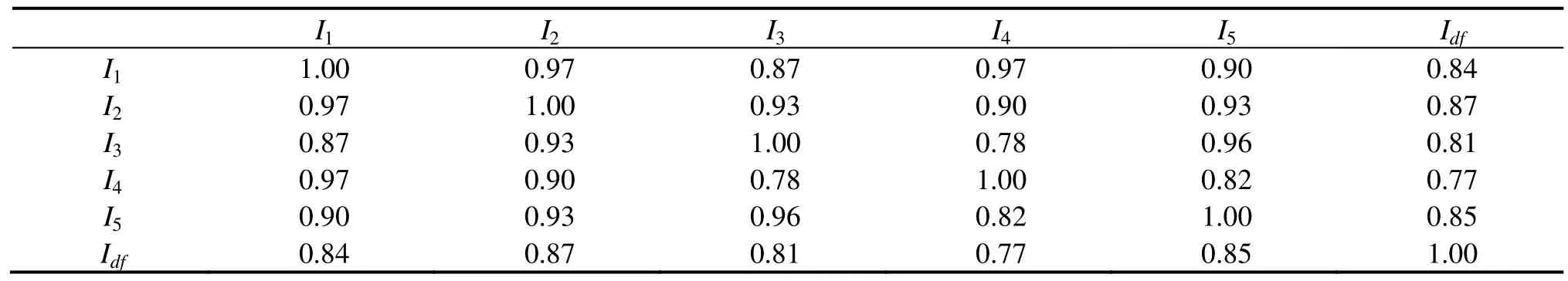
Table 1 The correlation coefficients between human activity indices and landslide and debris flow index in low latitude plateau
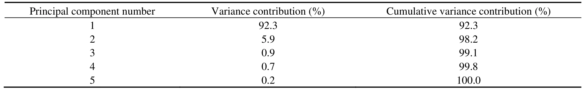
Table 2 The results of principal component analysis for five human activity indices in low latitude plateau
3.3 Summer precipitation index in low latitude plateau
The summer precipitation indexIrainin low latitude plateau was obtained by normalizing the sum of summer precipitation of 124 observation stations in Yunnan Province from 1961–2007.
3.4 Landslide and debris flow frequency index removing the impact of human activity in low latitude plateau
A univariate linear regression equation was set up with independent variableIHAand dependent variableÎdf.The equation is
After removing the impact of human activity, the series of landslide and debris flow frequency in low latitude plateau (I'df) was further calculated as
4 Results
4.1 The relationship between landslide and debris flow frequency in low latitude plateau and human activity
Figure 1 shows the temporal evolution of human activity indices and landslide and debris flow index in low latitude plateau. The landslide and debris flow frequency trends to annually increase 0.9 and has obvious stage feature. This frequency was relatively rare before the 1990s and relatively frequent after the 1990s. Using the M-K method, the abrupt point inIdfwas detected(Figure 2). Figure 2 shows that the solid and dashed lines intersect at 1993 which is located between two critical value lines. This indicates that the abrupt of the landslide and debris flow frequency in low latitude plateau took place in 1993. Landslide and debris flow frequency is only 9 times each year before 1993, but 34 times each year after 1993.
Figure 1 shows the temporal evolution of the landslide and debris flow index and the human activity synthetic index shares the same trend. Their correlation coefficient with a value of 0.86 passes the significance test atα=0.01 level.IHAtrends to annually increase 0.2 unit.To further obtain the phase and time-lag relationship in different time scales betweenIdfandIHA, the wavelet coherence analysis was applied, and their wavelet coherence spectrum was then obtained (Figure 3).
It can be seen from Figure 3 that there is a significant resonance period in 11–16 years band betweenIdfandIHA.The resonance period passes the significance test at 0.01 level. Their coherence phase is 0.7±0.6. This indicates that on the time scale of 11–16 years, the variation of human activity occurs about 0.2–2.8 years before land-slide and debris flow variation. The data ±0.6 is the convolution error in the calculation of phase angle. Because this convolution error cannot change the coherence phase symbol, the phase relationship of 0.2–2.8 years is stable. Thus, on a time scale of 11–16 years the increase of landslide and debris flow frequency in low latitude plateau of China may be mainly caused by geo-environmental degradation induced by human activity (such as cultivated area of crops and road length).
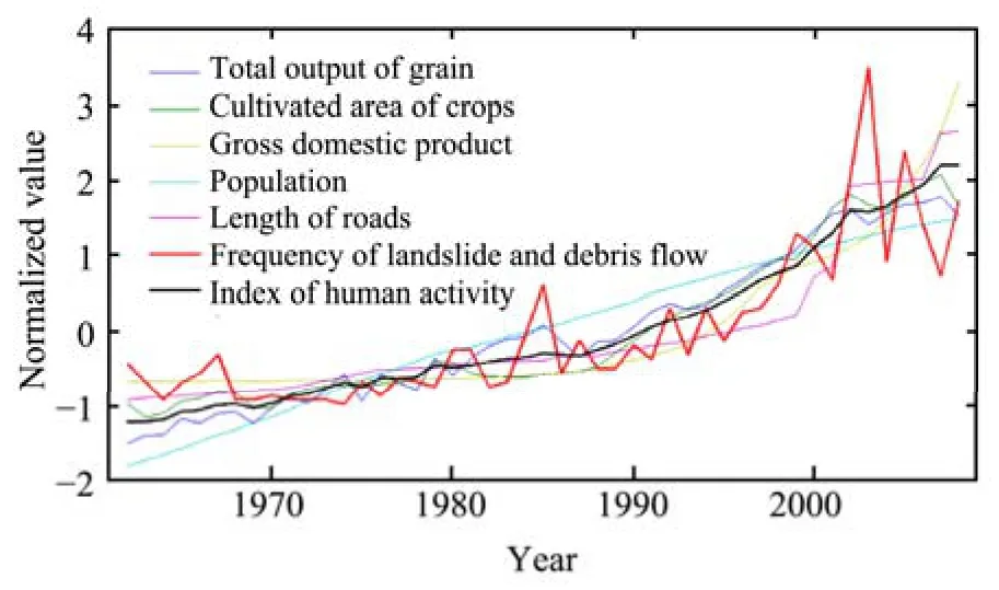
Figure 1 The temporal evolution of human activity index and landslide and debris flow index in low latitude plateau region
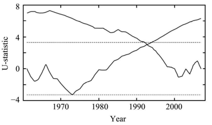
Figure 2 The abrupt test of landslide and debris flow frequency in low latitude plateau region. Dot-dashed line is the critical value of significant level at α=0.001.
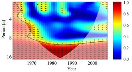
Figure 3 Wavelet coherence spectrum between Idf and IHA.Solid line is the critical value of the significant level of 0.01,arc line is the boundary effect area of continuous wavelet transformation, arrow from left to right indicates in-phase resonance relationship between Idf and IHA, vertical downward arrows indicates that IHA ahead leading π/2 than Idf
4.2 The relationship between landslide and debris flow frequency and summer rainfall in low latitude plateau
If the correlation coefficient betweenIrainandIdfwas directly calculated, their correlation coefficient would be 0.04, which does not pass the significance test at 0.1 level. This implies that there may be no significant relationship betweenIrainandIdf. From the aforementioned analysis, the possible cause is the impact of human activity on landslide and debris flow. Therefore, to remove this impact of human activity, a series of landslide and debris flow frequency in low latitude plateau (I'df) was further calculated with Equations(2)and(3).
Figure 4 shows thatIrainandI'dfhave very accordant change trend. Their correlation coefficient is 0.41 and passes the significance test atα=0.05 level. This indicates that there is a close relationship betweenIrainandI'df. The wavelet coherence analysis was also applied onI'dfandIrainto study the phase and time-lag on different time scale, and then their wavelet coherence spectrum was obtained (Figure 5).
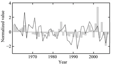
Figure 4 Temporal evolution of standardized Irain and I'df.Bar means I'df, polygonal line means Irain

Figure 5 Wavelet coherence spectrum between I'df and Irain.Solid line means the critical value at the significant level of 0.05,arc line is the boundary effect area of continuous wavelet transformation, arrow from left to right indicates in-phase resonance relationship between I'df and Irain, vertical downward arrowsindicates that Irain ahead leading π/2 than I'df
Figure 5 shows that the significant resonance period betweenI'dfandIrainis 2–8 years. The significant res-onance period range changes with time. Before the 1970s, their resonance period is about four years, whose reliability is weaker because of the boundary effect of wavelet analysis. From the end of the 1970s to 1980s,the resonance period prolongs to quasi-six-year. In the 21st century the resonance period shortens to quasi-three-year. On the scale of quasi-six-year, coherence phase is 0.7±0.1. This indicates that the variation of summer rainfall occurs about 0.6–0.8 years before that of landslide and debris flow from the end of the 1970s to 1980s. On a scale of quasi-three-year, coherence phase is 0.4±0.4. This indicates that the variation of summer rainfall occurs about 0.0–0.4 years before that of landslide and debris flow in the 21st century. Because convolution error respectively is ±0.1 and ±0.4 and cannot change the coherence phase symbol, the relationship ofI'dfandIrainis stable. This indicates that on the scales of quasi-six-year and quasi-three-year, more summer rainfall will induce higher frequency of landslide and debris flow, andvice versa. The results, where variation of summer rainfall occurs about 0.0–0.8 years before that of landslide and debris flow, agrees with results obtained by Duanet al. (2007).
4.3 The mid-long term evolution predicting model of landslide and debris flow frequency in low latitude plateau
The aforementioned analysis indicates that the variation of human activity occurs about 0.2–2.8 years before that of landslide and debris flow and the variation of summer rainfall occurs about 0.0–0.8 years before that of landslide and debris flow. Considering the one year time interval of observational data, the standardization series of human activity index from 1961 to 2003 and summer rainfall index from 1962 to 2004 were chosen as predictors and the standardization series of landslide and debris flow frequency in low latitude plateau from 1962 to 2004 was chosen as predicted. Using the least squares method, the mid-long term evolution predicting model of landslide and debris flow frequency in low latitude plateau was established as
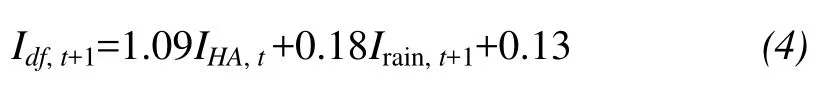
wheret=1961, 1962, …, 2004, the multiple correlation coefficient (0.90) of Equation(4)passes the significance test atα=0.01 level. The regression coefficients of human activity index (IHA,t) and summer rainfall index (Irain,t+1) are positive. This indicates that an increase ofIHA,tandIrain,t+1will increase the frequency of landslide and debris flow; andvice versa, which further confirms the results of wavelet coherence analysis.
Figure 6 intuitively reflects the aforementioned multiple correlation coefficient test. The points determined by fitting and observational values are very close to and even on the diagonal. This indicates that the model has very good historical fitting ability. The standardization series of landslide and debris flow frequency in low latitude plateau from 2005 to 2007 was used as an independent sample to test the prediction ability of Equation(4). Figure 6 shows that the distribution of points of the independent sample is in accordance with that of fitting points, namely, the points of independent sample is also close to the diagonal. This indicates that Equation(4)also has good prediction ability, and can be used to predict landslide and debris flow frequency in low latitude plateau.
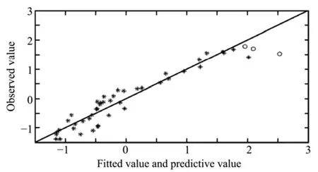
Figure 6 The fitting and predicting effect test of mid-long term evolution predicting model of landslide and debris flow disasters frequency in low latitude plateau region (*: fitting value; ○: independent sample test value)
5 Conclusions and discussion
(1) The mid-long term evolution of landslide and debris flow disaster trends to annually increase 0.9 and has obvious stage feature. The abrupt from rare to frequent period took place in 1993. There is a close relationship between human activity and landslide and debris flow frequency. On a time scale of 11–16 years, there is significant in-phase resonance oscillation between human activity and landslide and debris flow frequency, in which the variation of human activity occurs about 0.2–2.8 years before that of landslide and debris flow. On this longer time scale, the increase of landslide and debris flow frequency in low latitude plateau of China may be mainly caused by geo-environmental degradation induced by human activity such as deforestation, expanding cultivated area of crops, and increasing road length.
(2) After the impact of human activity is removed,there is significant positive correlation between landslide and debris flow frequency and summer rainfall in low latitude plateau of China. On a time scale of quasi-three and quasi-six years, there are significant in-phase resonance relationships between landslide and debris flow frequency and summer rainfall, in which the variation of summer rainfall occurs about 0.0–0.8 years before landslide and debris flow variation. The more (less) summer rainfall occurs, the higher (lower) landslide and debris flow frequency become. Summer rainfall is another im-portant external cause for landslide and debris flow in low latitude plateau of China.
(3) Based on the results of wavelet coherence analysis, the model of landslide and debris flow frequency in low latitude plateau was built with one year ahead human activity index and summer rainfall index in the concurrent year as predictors and landslide and debris flow frequency in low latitude plateau as predictant.
(4) Compared to the traditional Fourier transform method, wavelet transform is the local transformation of time and frequency domain, which can effectively extract information from the signal. Through the calculation function, such as stretching and horizontal shifting,the signal is analyzed by multi-scale refinement. This method has been widely applied in analyzing characteristics of the signal cycle. Wavelet coherence analysis is a development of wavelet analysis method, which can be used to analyze the resonance cycle and its phase relationship of two time series. From the aforementioned application results, it can be seen that this method has universality to some extent and can be applied to research on mid-long term evolution of landslide and debris flow in other areas.
The summer rainfall index defined in this paper has no significant relationship with landslide and debris flow frequency in low latitude plateau, which is independent to the definition of summer rainfall index. According to Tao and He (2008), precipitation of Yunnan Province does not significantly increase upward with time, which is different from the significantly upward trend of landslide and debris flow. The different precipitation indices can reflect the evolution characteristics of precipitation in Yunnan and has no significant relationship with landslide and debris flow. Since the evolution of landslide and debris flow frequency after removing the impact of human activity coheres with all kinds of precipitation indices, it is necessary to remove the impact of human activity for research on the relationship between precipitation and landslide and debris flow.
The authors are very thankful to two reviewers for proposing helpful suggestions. This project is supported by National Natural Science Foundation of China (Grant No.U0933603) and National Science and Technology Support Program (Grant No. 2011BAC09B07).
Cannon SH, Gartner JE, Wilson RC, Bowers JC, Laber JL, 2008.Storm rainfall conditions for floods and debris flows from recently burned areas in southwestern Colorado and southern California.Geomorphology, 96: 250–269.
Chau KT, 1995. Landslides modeled as bifurcations of creeping slope with nonlinear friction law. Int. J. Solids Struc., 32: 3451–3464.
Chen D, Yu SH, Jiang YH, 2004. Research on radar monitoring system of mud-rock flow and landslip on the east side of Qinghai-Xizang Plateau. Plateau Meteorology, 23: 130–133.
Chen NS, Xie WY, Li ZL, 2004. Division and prediction of debris flow in mountain area of southwest China. Plateau Meteorology, 23:134–140.
Cui P, 1991. Studies on condition and mechanism of debris flow initiation by means of experiment. Chinese Science Bulletin, 36:1650–1652.
Cui P, Yang K, Chen J, 2003. Relationship between occurrence of debris flow and antecedent precipitation: taking the Jiangjia Gully as an example. Science of Soil and Water Conservation, 1: 11–15.
Dai FC, Lee CF, 2001. Frequency-volume relation and prediction of rainfall-induced landslides. Engineering Geology, 59: 253–266.
Deng ZY, Min QW, Zhang Q, Li WH, Liu XS, Wang LX, Lu Q, Li SD,Cao JH, Xu JQ, 2010. Summarize of study of ecological meteorological disaster in China. Plateau Meteorology, 29: 810–817.
Ding JX, Yang ZH, Shang YJ, Zhou SH, Yin JT, 2006. New method of temporal and spatial forecast of the precipitation-typed landslide.Science in China, Series D: Earth Sciences, 36: 579–586.
Du HL, Niu XX, Yin KL, Xie JM, Liu LL, 2006. Study of meteorological forecasting and warning for landslide and debris flow in Zhejiang Province. Plateau Meteorology, 25: 151–158.
Duan X, Tao Y, Liu JY, Peng GF, 2007. The relationship between the landslide and debris flows and the precipitation in Yunnan Province under conditions of different geology and geomorphology. Meteorological Monthly, 33: 33–39.
Fei XJ, Shu AP, 2004. Motion Mechanism of Debris Flows and Disaster Prevention and Control. Tsinghua University Press, Beijing.
Grinsted A, Moore JC, Jevrejeva S, 2004. Application of the cross wavelet transform and wavelet coherence to geophysical time series. Nonlinear Processes in Geophysics, 11: 561–566.
Guzzetti F, Peruccacci S, Rossi M, Stark CP, 2007. Rainfall thresholds for the initiation of landslides in central and southern Europe. Meteorology and Atmospheric Physics, 98: 239–267.
Hu XW, 2001. Distribution and development law of geological hazards beside the line from Erlang Mountain to Kangding Town in the No.318 National Road. Journal of Natural Disasters, 11: 65–88.
Huang JY, 2000. Meteorological Statistical Analysis and Prediction Methods. Meteorological Press, Beijing.
Iverson RM, 2000. Landslide triggering by rain infiltration. Water Resources Research, 36: 1897–1910.
Li J, Liao YS, Zhan B, Shen TY, 2007. The preliminary application of ensemble prediction in flash flood forecasting. Plateau Meteorology, 26: 854–861.
Li XY, Wang LX, Zhang YS, Zhang HQ, 2004. Analysis of roles of human activities in land desertification in arid area of Northwest China. Scientia Geographica Sinica, 24: 68–75.
Liu XL, Mo DW, 2003. Debris Flow Risk Assessment. Sichuan Sciences and Technique Press, Chengdu.
Liu XL, Tang C, 1995. Debris Flow Hazard Assessment. Science Press,Beijing.
Liu XL, Zhao Y, Li XZ, Ni HY, Su PC, 2006. Disaster risk assessment of typical debris flows in Dechang County of Sichuan. Journal of Natural Disasters, 15: 11–15.
Ostwald M, Chen DL, 2006. Land-use change: impacts of climate variations and policies among small-scale farmers in the Loess Plateau, China. Land Use Policy, 23: 361–371.
Peng GF, 2004. The relationship between meteorological geologic hazards and precipitation (The Science and Technological Papers of Meteorological Forecasting and Alarm of Geologic Disaster). Meteorological Press, Beijing.
Qin SQ, Zhang ZY, Wang ST, Huang RQ, 1993. An Introduction to Nonlinear Engineering Geology. Southwest Jiaotong University Press, Chengdu.
Ren J, He DM, Fu KD, Li YG, 2007. Sediment change under climate changes and human activities in the Yuanjiang-Red River Basin.Chinese Science Bulletin, 52: 142–147.
Shan JS, Wei L, Bian XG, Zhang YZ, Liu XY, Liu XF, 2008. An operational system of landslide disaster forecasting and warning based on Web-GIS Technique. Plateau Meteorology, 27: 222–229.
Sun Y, Wang YL, Tang Y, Li XH, 2011. Construction of the radar concept model of short-time rainstorm. Plateau Meteorology, 30:235–244.
Tang BX, 2000. Debris Flow in China. Commerce Press, Beijing.
Tang C, Wang RY, Zhou JQ, 1995. The Predictive Methods and Evaluations Methods Research of Main Area of Landslide and Debris Flow in Yunnan. Yunnan Science and Technology Press,Kunming.
Tang C, Zhu J, 2003. Landslide and Debris Flow in Yunnan. Commerce Press, Beijing.
Tao Y, He Q, 2008. The temporal and spatial distribution of precipitation over Yunnan Province and its response to global warming.Journal of Yunnan University, 30: 587–595.
Tao Y, Tang C, Cun CQ, Yang XD, 2005. The meteorological causes for flash flood and debris flow on July 5, 2004 in Dehong Prefecture of Yunnan Province. Journal of Mountain Science, 23: 53–62.
Tao Y, Tang C, Duan X, 2009. The analysis on Yunnan landslide and debris flow hazards and precipitation characteristics for the occurrence from 2001 to 2005. Journal of Natural Disasters, 18:180–186.
Torrence C, Compo GP, 1998. A practical guide to wavelet analysis.Am. Meteorol. Soc., 79: 61–78.
Vicente-Serrano SM, Lasanta T, Romo Alfredo, 2005. Analysis of spatial and temporal evolution of vegetation cover in the Spanish central pyrenees: role of human management. Environmental Management, 34: 802–818.
Wang RQ, Zhou YH, Wang L, Ke YM, 2006. The studies on mountain mud-rock flow critical rainfall and rainfall zoning of Hubei Province. Plateau Meteorology, 25: 330–334.
Wang YY, Zhan QD, Chen XQ, Han WL, 2003. Stress-strain self-organization criticality of debris flows. Chinese Science Bulletin, 48: 976–980.
Wang YY, Zhan QD, Tian B, Hong Y, Zou RY, 2008. The relationship between the variation of annual rainfall and the variation of sediment transport by debris flows at Jiangjia Gully in the upper reach of Yangtze River. Journal of Mountain Science, 26: 590–596.
Wang Z, Chen YY, 2007. Analyses on major effect systems and typical atmospheric circulation triggering mountain torrential disasters in Chongqing. Plateau Meteorology, 26: 609–614.
Wei FQ, Hu KH, Chen J, 2005. Determination of effective antecedent rainfall for debris flow forecast. Journal of Mountain Science, 23:4453–4457.
Wei FY, 1999. Modern Climate Statistical Diagnosis and Prediction Technique. Meteorological Press, Beijing.
Wei JB, Xiao DN, Xie FJ, 2006. Evaluation and regulation principles for the effects of human activities on ecology and environment.Progress in Geography, 25: 36–45.
Xin ZB, Xu JX, Zheng W, 2007. The effects of climate changes and human activities on the vegetational cover in Loess Plateau. Science in China, Series D: Earth Sciences, 37: 1504–1514.
Yu SH, 2003. Analyses on spatial-temporal characteristics of mud-rock flow and landslip in Sichuan Basin and its meteorological cause.Plateau Meteorology, 22: 83–89.
Zhang GP, Xu J, Bi BG, 2009. Relations of landslide and debris flow hazards to environmental factors. Chinese Journal of Applied Ecology, 20: 653–658.
Zhang JH, Wei FQ, Liu SZ, Gao C, 2008. Possible effect of ENSO on annual sediment discharge of debris flows in the Jiangjia Ravine based on Morlet wavelet transforms. International Journal of Sediment Research, 23: 267–274.
Zhang SY, 2005. Meteorological Forecast Base of Geologic Hazard.Meteorological Press, Beijing.
Zhang YY, Hu XW, Zhu HY, 2007. Prospect of research on relationship between landslide and rainfall. Journal of Natural Disasters, 16:104–108.
Zhou GS, 2003. Global Carbon Cycle. Meteorological Press, Beijing.
 Sciences in Cold and Arid Regions2013年6期
- Sciences in Cold and Arid Regions的其它文章
- Identification of an AP2 gene related to open flowering in diploid wheat (Triticum monococcum)
- Involvement of anti-oxidative enzymes, photosynthetic pigments and flavonoid metabolism in the adaptation of Reaumuria soongorica to salt stress
- Spatial coupling relationships of gas hydrate formation in the Tibetan Plateau
- The morphological characteristics of glacial deposits during the Last Glaciation, taking the Parlung Zangbo River Basin as an example
- The change of Ningchan River Glacier No. 3 at Lenglongling, east Qilian Mountain, China
- Seasonal variation in soil microbial biomass carbon and nitrogen in an artificial sand-binding vegetation area in Shapotou, northern China