
The morphological characteristics of glacial deposits during the Last Glaciation, taking the Parlung Zangbo River Basin as an example
2013-10-09 08:11RenRongChenShangZheZhouYingBinDeng
RenRong Chen , ShangZhe Zhou *, YingBin Deng
1. School of Geography, South China Normal University, Guangzhou, Guangdong 510631, China
2. Department of Geography, University of Wisconsin-Milwaukee, Milwaukee, WI 53201-0413, United States
1 Introduction
The coming of the Ice Age is one of the most significant features of the Quaternary. Glaciers have repeatedly expanded since the Quaternary and conserved a wealth of ancient moraines and outwash (Miet al., 2002).Moraine morphology is a direct way to understand past climatic fluctuations. Glacial accumulation, movement,and ablation constitute a complex system involving many interactions between geology and atmosphere,accompanied by energy transformation. Therefore, glacial activity is an important indicator of ancient climatic fluctuations (Shiet al., 2000). Zhanget al. (2010)showed that glaciers in Gongga Mountain are retreating and ice reserves decreased from 1966 to 2002. The temperature rise associated with global warming may be the main reason for the modern glacier retreat. Maritime glaciers are sensitive to climatic change and leave abundant glacial landforms with which to investigate environmental evolution. Liet al. (1986) proposed the Guxiang Glaciation and the Baiyu Glaciation after geomorphologic investigations in the Bodui Zangbo River Basin. These two glaciations correspond to Marine Isotope Stages 2 through 4 (MIS2–MIS4) and MIS6,respectively (Zhouet al., 2007). The glacial deposits of the Last Glaciation are located at the mouth of glacial valley studied here, and are large-scale and well-preserved. This study analyzes the glacial deposits of ten glacial valleys in the Parlung Zangbo River Basin to elucidate the morphological characteristics of moraine ridges and reveal the processes of climate change.
2 Study region
The Parlung Zangbo River is the largest northern tributary of the Yarlung Zangbo River, which flows from east to west in the southeastern Tibetan Plateau. The basin is situated between Nyainqentanglha Mountains in the north, Hengduan Mountains in the east, and the Himalaya Mountains in the west. The mountains consist of active tectonic landforms with high mountain peaks and deep valleys (Figure 1). The Parlung Zangbo River source is the Laigu Glacier and it flows from east to west by way of Ranwu, Songzong, Guxiang, and Tongmai,and then affluxes to the Yarlung Zangbo River after collecting Yigong Zangbo River water (Chinese Academy of Sciences, 1974, 1985; Guanet al., 1984).
The Parlung Zangbo River Basin contains 2,968 contemporary glaciers; their average area and thickness are 2.14 km2and 109 m, respectively (Miet al., 2002;Wang, 2006; Wang, 2007). Southeastern Tibet is a typical region of monsoonal maritime glaciers in China and is greatly affected by the South Asian Monsoon. This is due to the influence of the "Grand Canyon" of the Yarlung Zangbo River by which large amounts of precipitation from the Bay of Bengal are delivered through the South Asian Monsoon to southeastern Tibet (Shi and Liu,2000). The glaciers were identified as temperate glaciers based on their internal ice temperatures of -1 to 0 °C,summer air temperatures of 1–5 °C near the snowline,and rapid current velocities of 80–440 m/a (Zhouet al.,2010).
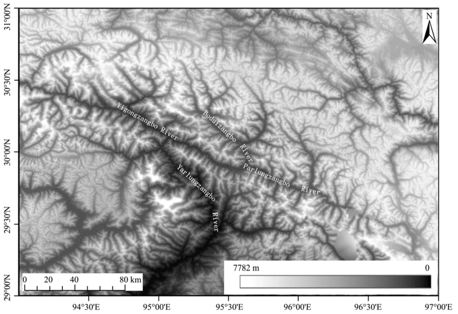
Figure 1 DEM image of the Parlung Zangbo River Basin and the Great Bend of the Yarlung Zangbo River
3 Methods
Recent improvements in Geographic Information System (GIS) techniques have undoubtedly enhanced the study of glacial landforms all over the world. Huet al.(2010) applied the Global Positioning System (GPS)method to survey the glacial landform in the Rongbuk Valley of Everest, calculating the average area, till volume, and surface area of its moraines. For micro-erosion landforms of glacial regions, the spatial analysis technology of GIS also plays an important role. Liet al.(2010) studied the evolution process of micro-relief in the Rongbuk Valley of Everest. We analyzed the glacial deposits which are located at the mouth of their valley of ten valleys in the Parlung Zangbo River Basin by using satellite images provided by Google Earth software and Digital Elevation Model (DEM) data (Figure 1). We used field mapping, sediment logical and geomorphic methods to define the characteristics and nature of glaciations.
The glacial landforms of the ten valleys are presented in Figure 2. The entire moraines are located in the Parlung Zangbo River Basin. Six terminal moraines are located in the trunk valley of the Parlung Zangbo River and are named P1, P2, P3, P4, P5, and P6. Three moraines are located in the tributary valley (Bodui Zangbo River)and are named PB1, PB2, and PB3. P7 belongs to the Quzong Zangbo Valley, which is also a tributary valley of the Parlung Zangbo River Basin. The detailed parameters of these contemporary glaciers and ancient moraines are listed in Table 1 and Table 2.
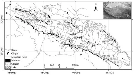
Figure 2 Distribution of the studied glacial landforms in the Parlung Zangbo River Basin
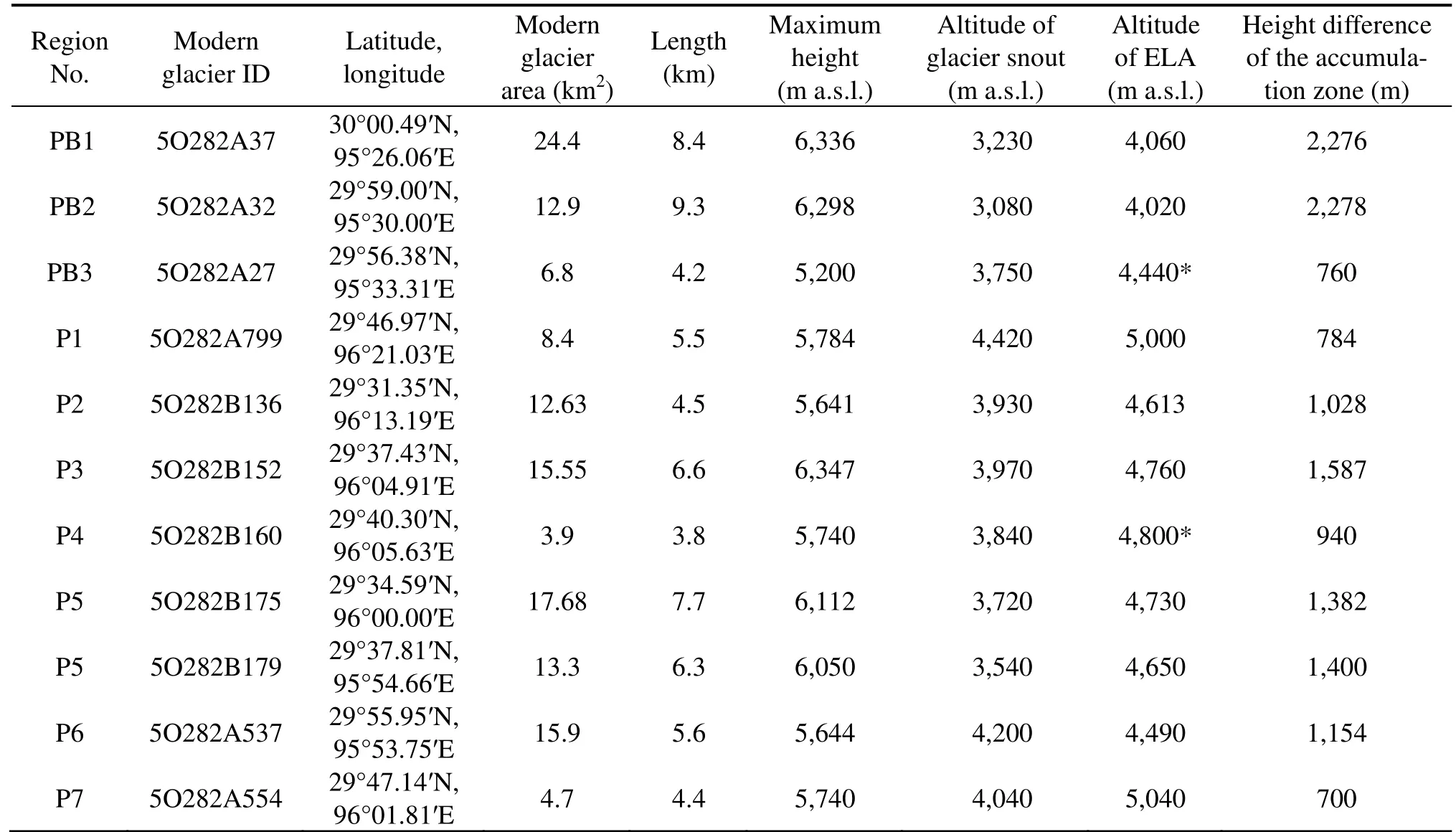
Table 1 Glacier inventory information of the 11 glaciers in the Parlung Zangbo River Basin
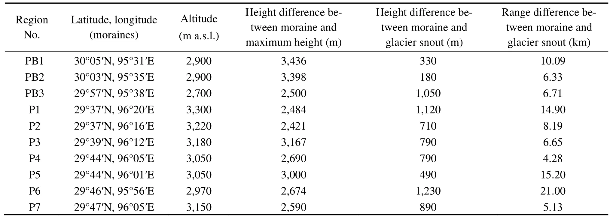
Table 2 Moraine information of the Last Glaciation and associated parameters
4 Glacial landforms in the Parlung Zangbo River Basin
4.1 Glacial landforms in the Parlung Zangbo Valley
The Bacuo Glacier is the source of P1; its area and length are 8.4 km2and 5.5 km, respectively. The altitude of the contemporary glacial tongue is 4,420 m a.s.l. (Miet al., 2002). This glacial landform (29°37′N, 96°20′E) is unique and only preserves the west part of the moraine. It can be divided into three parts (Figure 3). Part A is the main moraine ridge, which is the largest scale one among the three parts and well-preserved. Its advancing direction is perpendicular to the trunk valley and the ancient glacier extended to the other side of the Parlung Zangbo Valley. The relative height of Part A is 100 m, which indicates that ancient glacier has stagnated for a long time. Part B is located between A and C, and its scale is smaller than Part A. Part C is the smallest one that lies outside of Part B.

Figure 3 Map showing the study area P1 and the distribution of modern glaciers (a), and photo of the moraine ridges at the mouth of the glacial valley (b)
The area and length of P2 are 12.63 km2and 4.5 km,respectively. The altitude of the contemporary glacial tongue is 3,930 m a.s.l. (Miet al., 2002). This glacial landform (96°16′E, 29°37′N) can be divided into three parts (Figure 4). The eastern side of the terrain of P2 is relatively flat and preserves an extensive moraine. Part A extends to the middle of the trunk valley; it is residual probably because of the high erosion rate or glacial reactivity. The eastern Part C is more extensive than the other parts. The central altitude of Part D is 3,293 m a.s.l.and 30 m higher than the eastern Part C, which means they were asynchronously constructed.
The summit altitude of the P3 glacial valley is 6,347 m a.s.l.. The area and length are 15.55 km2and 6.5 km,respectively. The altitude of the contemporary glacial tongue is 3,970 m a.s.l. (Miet al., 2002). The ancient glaciers of P3 (29°39′N, 96°12′E) are strongly affected by the local terrain. The size and shape of the moraine ridges are different at each side of the valley (Figure 5). The north side is a tall, curved lateral moraine whereas the moraine of the south side is relatively small. Ancient glaciers were blocked by the highlands when they advanced at the mouth of the glacial valley, and the direction of glacial advance changed from north to southeast. The relative height of the northern Moraine A is 100 m. The southern Moraine A is the combination of three sets of parallel moraine ridges, and the relative height of the largest central moraine ridge is about 60 m.Some smaller moraine ridges exist inside the southern Moraine A, named Moraine H whose relative height is 40 m; they were built after Moraine A. The erosion surface on the northern Moraine A indicates a young glacial advance, and it has the same altitude as the southern Moraine H. The residual Moraine B lies outside the southern Moraine A, and it was constructed before Moraine A.
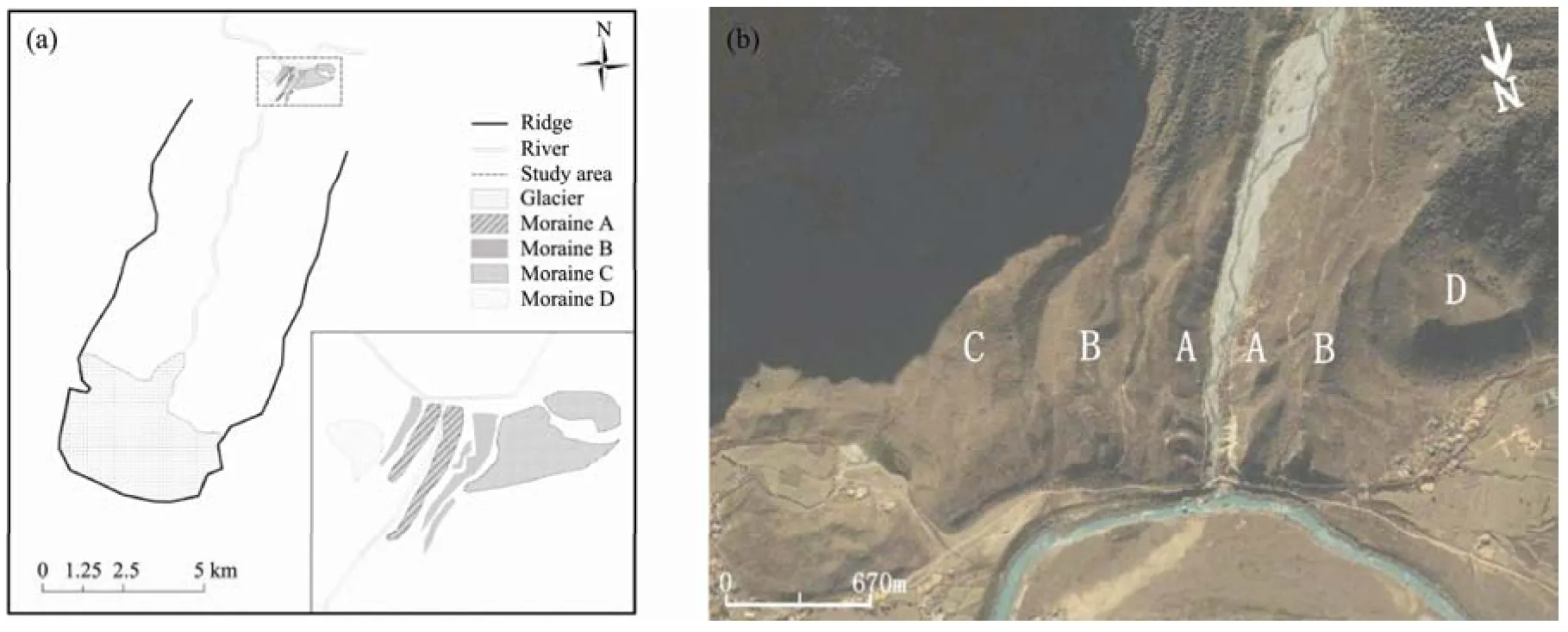
Figure 4 Map showing the study area P2 and its distribution of modern glaciers (a) and the moraine ridges at the mouth of the glacial valley (b)
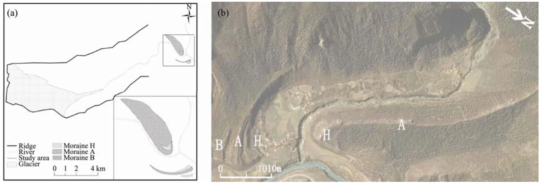
Figure 5 Map showing the study area P3 and the distribution of modern glaciers (a), and the moraine ridges at the mouth of the glacial valley (b)
P4 is situated in the Songzong region. The topography of this region is complex because contains a wealth of fluvial, glacial, and lacustrine deposits. The Songzong region used to develop a great ancient lake because the glacier advanced downstream and built a huge moraine ridge that blocked the Parlung Zangbo River during the Last Glaciation (Zenget al., 2007). The summit altitude of the P4 glacial valley is 5,740 m a.s.l.. The area and length are 3.9 km2and 3.8 km, respectively. The altitude of the contemporary glacial tongue is 3,840 m a.s.l. (Miet al., 2002). The terminal moraine can be divided into three parts (Figure 6). The main moraine ridge (Part A)was eroded by normal erosion and some small ditches exist on the moraine surface. Moraine A is a large,curved ridge that might be formed during or before the Last Glacial Maximum (LGM) because the lacustrine terraces outside the main moraine were constructed during the LGM (Zenget al., 2007). Moraine B is located at the eastern outer edge of Moraine A. Moraine H is on the inner side of Moraine A.
P5 is located in a composite glacial valley. Two large-scale contemporary glaciers constitute the headwater. The summit altitude of the Rongcuo glacial valley is 6,112 m a.s.l.. The area and length are 17.68 km2and 7.7 km, respectively. The altitude of the contemporary glacial tongue is 3,720 m a.s.l.. The summit altitude of the Zhaguo glacial valley is 6,050 m a.s.l.. The area and length are 13.3 km2and 6.3 km, respectively. The altitude of the contemporary glacial tongue is 3,540 m a.s.l.(Miet al., 2002). The moraine scale of P5 (96°01′E,29°44′N) is smaller than P4 and is combined with a different terrain at the mouth of the glacial valley that displays a different moraine morphology. The terminal moraine can be divided into three parts (Figure 7): the main moraine ridge (Part A), the middle moraine ridge (Part B), and the outer moraine ridge (Part C). Moraine A is the most well-preserved and the youngest one. Moraines B and C are partly residual due to normal erosion. The ancient glacier changed direction when it advanced into the trunk valley and constructed Moraines B and C.
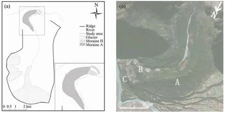
Figure 6 Map showing the study area P4 and distribution of modern glaciers (a), and photo of the moraine ridges at the mouth of the glacial valley (b)

Figure 7 Map showing the study area P5 and distribution of modern glaciers (a), and photo of the moraine ridges at the mouth of the glacial valley (b)
The contemporary glacier of P6 is the Nizu Glacier.The area and length of P6 are 15.9 km2and 5.6 km,respectively. The altitude of the contemporary glacial tongue is 4,200 m a.s.l. (Miet al., 2002). The moraine morphologies of P6 and P4 are similar but the curved moraine ridge of P6 has a greater scale. The glacial landform (29°46′N, 95°56′E) of P6 can be divided into at least two parts (Figure 8): the main moraine ridge is Part A, and Part B or Part C is residual outside of Part A. Other moraines might be covered by later glacial advance.
4.2 Glacial landforms in the Quzong Zangbo Valley
The summit altitude of the P7 glacial valley is 5,740 m a.s.l.. The area and length are 4.7 km2and 4.4 km,respectively. The altitude of the contemporary glacial tongue is 4,040 m a.s.l.. (Miet al., 2002). P7 (29°47′N,96°05′E) is situated in the Quzong Zangbo River Basin,which is a tributary of the Parlung Zangbo River Basin.The outstanding feature of P7 is the dual structure of the moraine ridges. In the flat outlet, the distribution of the moraines indicates the stage of glacial actions. Moraine ridges at the mouth of the Charao Valley can be divided in three parts (Figure 9): the main moraine ridge (Moraine A), the parallel ridges in the north side (Moraine B),and the outer moraine in the south side (Moraine C). The height of Moraine A is up to 170 m above the valley floor. The stage of morainic formation is Moraine C >Moraine B > Moraine A according to their distribution.The ancient glacier fluctuated at least three times and constructed the terminal moraine.
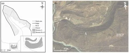
Figure 8 Map showing the study area P6 and distribution of modern glaciers (a), and photo of the moraine ridges at the mouth of the glacial valley (b)
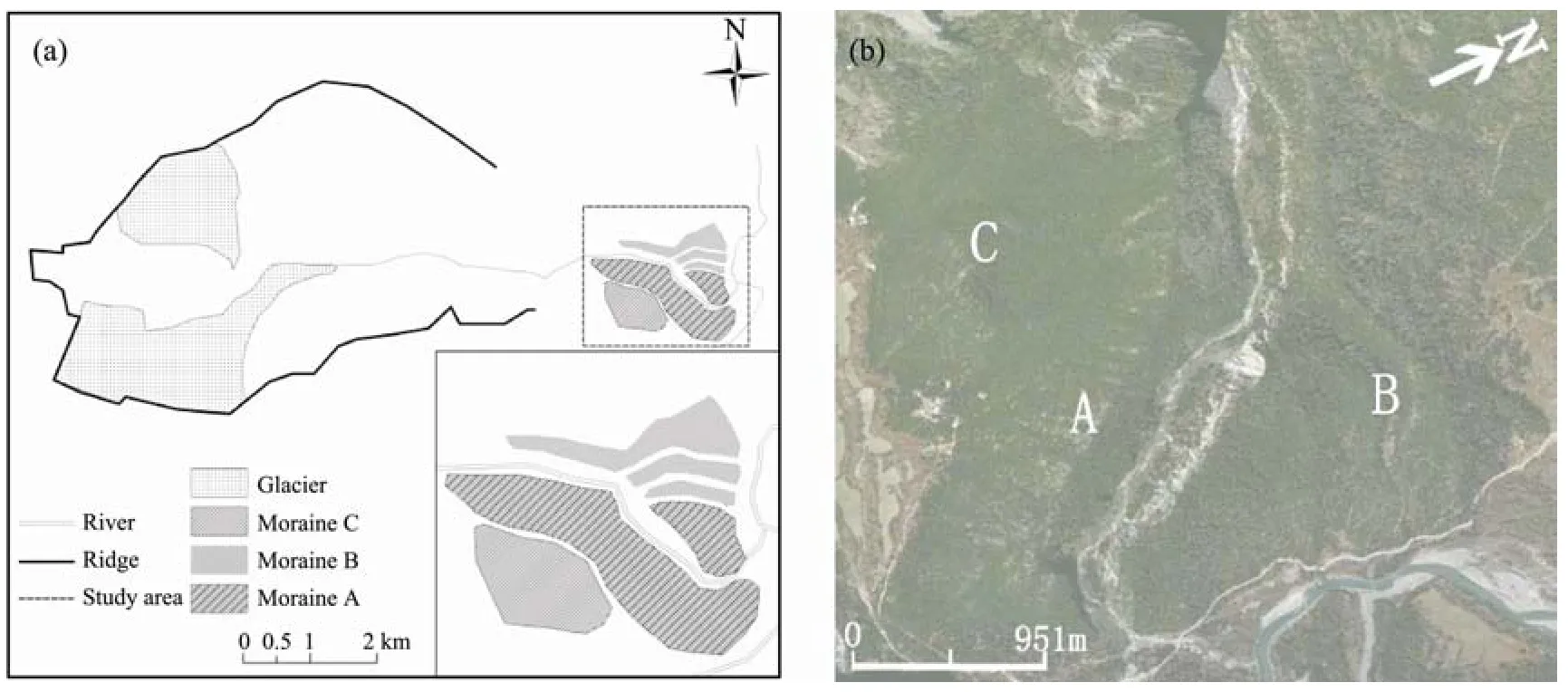
Figure 9 Map showing the study area P7 and distribution of modern glaciers (a), and photo of the moraine ridges at the mouth of the glacial valley (b)
4.3 Glacial landforms in the Bodui Zangbo Valley
The summit altitude of the PB1 glacial valley is 6,336 m a.s.l.. The area and length are 24.4 km2and 8.4 km,respectively. The altitude of the contemporary glacial tongue is 3,230 m a.s.l. (Miet al., 2002). PB1 (95°31′E,30°05′N) is situated in the Baiyu Valley of the Bodui Zangbo River Basin. Moraine ridges of the Baiyu Valley can be divided in three parts (Figure 10): Part A is the main moraine ridge and Part B is situated in the northern side of Part A, which is at a much smaller scale. Part C is the outer moraine in the southeastern side, which is residual. The height of the main moraine ridge is up to 200 m above the valley floor and its length is 3 km. Moraine B comprises three parallel ridges, which are smaller than other two moraine ridges. Moraine C is irregular and is significantly different from the others. Moraine A was constructed during the LGM of MIS2, according to its terrestrial cosmogenic nuclide (TCN) ages (Zhouet al., 2007).Moraine B indicates three periods of glacial fluctuation(Yanget al., 2005). Moraine C might have been built during MIS3 or MIS4, given its current position (Zhouet al., 2010).
The area and length of contemporary glacier PB2 are 12.9 km2and 9.3 km, respectively. The altitude of the contemporary glacial tongue is 4,020 m a.s.l. (Miet al.,2002). PB2 (95°35′E, 30°03′N) is situated in the Zhuxi Valley of the Bodui Zangbo River Basin. The moraine ridges of the Zhuxi Valley can be divided into three parts according to the distribution (Figure 11): Part A is the main moraine ridge that blocks the Zhuxi Valley, Part B is three sets of parallel moraine ridges, and Moraine C is irregular and residual in the southeastern part of Part A.The stage of moraines formation is Moraine C > Moraine B > Moraine A according to their distribution. The ancient glacier fluctuated at least three times and constructed the terminal moraine.
No till was deposited inside the main moraine ridge because of the special topography of this glacial valley.Liet al. (1986) suggested that the ancient glacier of the Zhuxi Valley has been in two extreme situations since the Baiyu Glaciation. One situation maintained the extent to which the ancient glacier advanced into the mouth of valley. The other is maintaining the scale of the contemporary glacier. No transitory stage exists between the two situations and no till has been left inside the main moraine ridge. The rearward cliff of the accumulation area is very steep, and the latter does not change when the ELA fluctuates on the cliff. The glacier advanced when the ELA decreased to the bottom of the cliff and extended to the mouth of glacial valley. The area and length of ancient glacier were 53 km2and 17 km, respectively, at that time (Liet al., 1986).

Figure 10 Map showing the study area PB1 and distribution of modern glaciers (a), and photo of the moraine ridges at the mouth of the glacial valley (b)
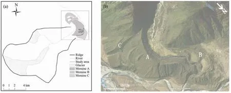
Figure 11 Map showing the study area PB2 and distribution of modern glaciers (a), and photo of the moraine ridges at the mouth of the glacial valley (b)
The area and length of contemporary glacier PB3 are 6.8 km2and 4.2 km, respectively. The altitude of the glacial tongue is 3,750 m a.s.l. (Miet al., 2002). PB3 (29°57′N,95°38′E) is situated in the Bodui Zangbo River Basin. The ancient glacier and moraines’ scale of PB3 are much smaller than PB1 and PB2. The moraine ridges of PB3 can be divided into two parts (Figure 12): Part A is the main moraine ridge and Part H is upstream of the glacial valley.The main moraine ridge might have been constructed during the LGM of MIS2, similar to PB1 and PB2 (Zhouet al.,2010). Moraine H might have been formed during the Younger Dryas (YD) or the Heinrich 1 (H1) event.
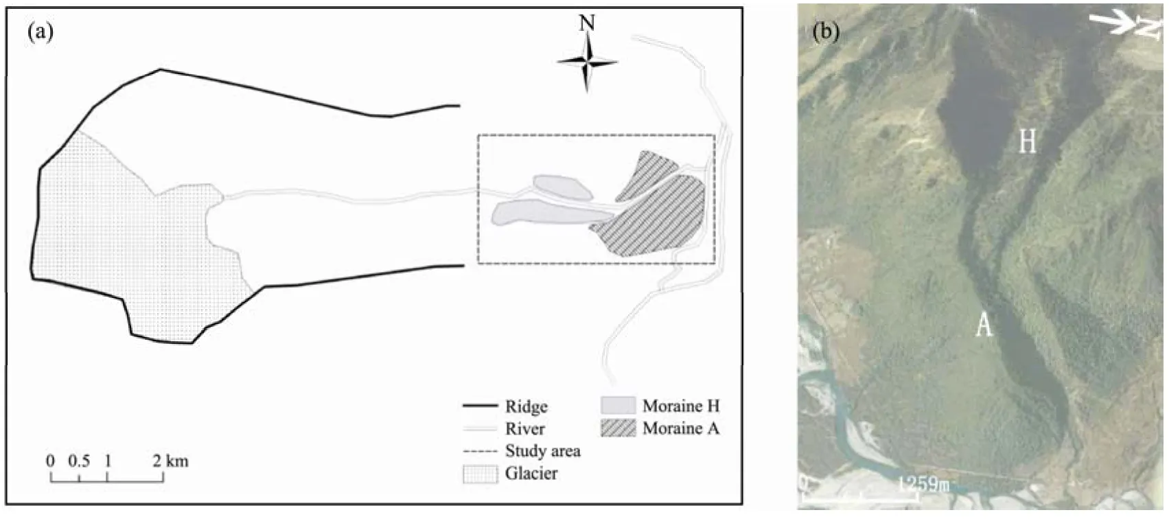
Figure 12 Map showing the study area PB3 and distribution of modern glaciers (a), and photo of the moraine ridges at the mouth of the glacial valley (b)
5 Disscusion of morphological features
The moraine ridges are located at the mouth of the glacial valley and can be divided into roughly three parts.The morphological characteristics of the glacial landforms of the ten valleys are: (i) the main moraine ridge(Part A) is the most striking and particularly distinct one in the moraine sequences, and (ii) Moraines B and C are residual and lie outside the main moraine ridge. Some ridges reflect the stage of glacial activity. Zhaoet al.(2002) found three sets of Pleistocene glacial deposits in the western part of the Nyainqentanglha Mountains and named them Ningzhong Glaciation, Paran Glaciation,and Laqu Glaciation. Paran Glaciation and Laqu Glaciation correspond to Guxiang and Baiyu glaciations, respectively.
The southeastern Tibetan Plateau is a typical region of monsoonal maritime glaciers due to the influence of the "Grand Canyon" of the Yarlung Zangbo River, by which large amounts of precipitation from the Bay of Bengal can be delivered through the South Asian Monsoon to southeastern Tibet. The old moraines are difficult to preserve due to the high erosion rate of the humid climate (Owenet al., 2005). Zhouet al. (2007) reported the10Be TCN dating results of PB1 (Baiyu Valley). The ages of the main moraine ridges range from 11.1 to 18.5 ka B.P., based on eight dating samples. It means the moraine ridges at the mouth of the glacial valley were formed during the Last Glaciation.
Moraine A was formed in MIS2 and Moraines B and C might have been constructed during MIS3 or MIS4,according to dating results in the Bozui Zangbo River Basin. Moraine B is a combination of several ridges (i.e.,B1, PB2, P1, and P7), which indicates that ancient glacier fluctuated frequently. Moraine C is residual and is mostly covered by Moraine A or eroded by normal erosion. The scale of Moraine C is larger than Moraine B, but smaller than Moraine A. However, we cannot distinguish the actual extent and scale of Moraine C. In previous field investigation, multiple moraine ridges of the Last Glaciation were puzzling until we considered that the Greenland Ice Core record revealed several climatic fluctuations (e.g., the D-O oscillation and the H event); this suggests that monsoonal maritime glaciers are sensitive to climate change and that these glaciers are likely to respond to these climatic events. It is certain that Moraine A was formed during MIS2 and no subsequent glacial advance exceeded the extent of MIS2.The extent of the glacial advance is getting smaller and smaller, which is similar to the situation in the Bozui Zangbo Valley,i.e., Moraine Linqiong corresponds to the H1/YD event, and Moraine Dana and Moraine Baitong correspond to Neoglaciation.
The extent of glaciations is determined by both temperature and precipitation. The time scale of stagnation of glaciers determines the size of moraines. Glaciers need lengthy stable time to construct a huge moraine. In the current study, the main moraine ridges (Part A) indicate the longest glacial stagnation time when the temperature dropped and ancient glaciers advanced to the mouth of the valley.
In the Guliya Ice Core record, the range of MIS2 is 10–30 ka B.P., including the LGM and the Late Glacial.The lowest temperature of the LGM occurred in 21 ka B.P.(18 ka B.P. of14C age), when the average temperature was 9–10 °C lower than in modern times (Yanget al.,1997; Shiet al., 2006). Glaciers advanced and constructed the main moraine ridges in the southeastern Tibetan Plateau as the result of reduced temperatures.The most important cooling event in the Late Glacial was the YD. According to the Guliya Ice Core record,temperature declined greatly during 12.2–10.5 ka B.P.(12 °C lower than in modern times and also lower than in LGM). The extent of cooling during the YD was greater than in the LGM, but the time scale of cooling was short (Shiet al., 2006). Glaciers advanced to a large extent to form the moraines but they are much smaller than the main moraine ridges because of the short-lived stagnation.
Moraine C is residual due to long-standing erosion. It was constructed before MIS2 according to its position.MIS3 or MIS4 may be the time that Moraine C developed.
The temperature of MIS3 was higher than in MIS2 and MIS4, but lower than in the Holocene megathermal period. The climate fluctuated three times and the cold stadial of MIS3 was equivalent to MIS2 and MIS4 (Shi and Yao, 2002; Shiet al., 2006). Wang (2010) reviewed the dating results in the Tibetan Plateau and peripheral mountains. He found that the local last glacial maximum(LLGM) in the Himalayas and in the southeastern Tibetan Plateau occurred in MIS3 rather than in the global LGM of MIS2. In the cold period of MIS3, abundant precipitation carried by strong Asia monsoon caused glacial advances.
Moraine C might have been formed in MIS4 because the temperature decreased abruptly and remained stable for a long time (Shiet al., 2006). According to the change of particle contents in the Guliya Ice Core record, MIS5a transformed to MIS4 during 76–65 ka B.P.. The enormous Toba volcano explosion in Sumatra caused a 6- to 10-year volcanic winter. The atmospheric circulation changed greatly and global temperature fell by 3–5 °C(Rampino and Slep, 1992). Moraine D of P2 was formed in earlier glaciations and might belong to the Guxiang Glaciation that corresponds to MIS6.
The average heights of the three sets of moraine ridges are presented in Table 3. The average height of Moraines A, B, and C are 165.7, 118.0, and 128.5 m,respectively,i.e., A > C > B. The relationship between the time scales of stagnation is A > C > B. The time scale of stagnation of glaciers determines the size of moraines;glaciers need lengthy stable time to construct a huge moraine. Moraine C is older than the others and is more difficult to preserve due to its high erosion rate caused by humid climate (Owenet al., 2005). The temperature decrease of Moraine A is greater than Moraine C when the distance between the terminal moraine and the contemporary glaciers is taken into consideration.
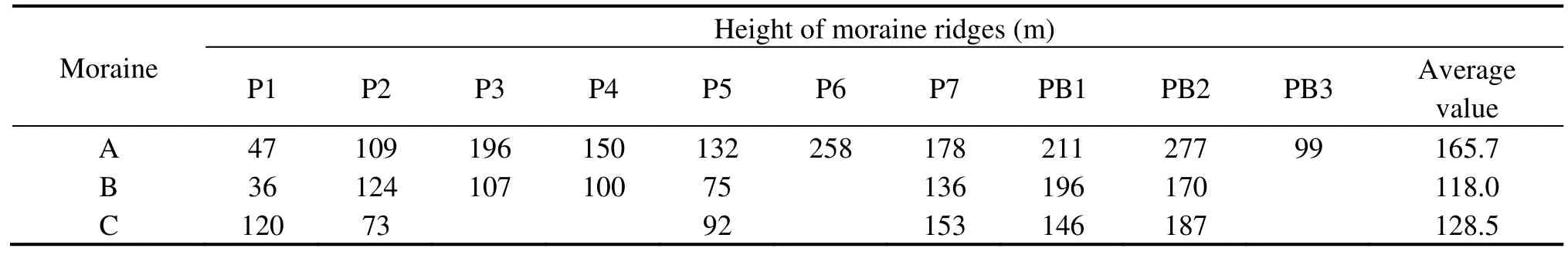
Table 3 The heights of moraine ridges of the Last Glaciation in the Parlung Zangbo River Basin
6 Conclusion
Southeastern Tibet is a typical region of monsoonal maritime glaciers in China which is greatly affected by the South Asian Monsoon. By studying the shape, extent,and scale characteristics of glacial deposits in ten glacial valleys in this region, and if with the support of high-precision system dating, we can reconstruct the climatic fluctuation history that glacial landforms have displayed since the Penultimate Glaciation, especially since the Last Glaciation. There is great value and research potential in this reconstruction to understand the relationship between regional and global climatic change.
The authors are very thankful to two reviewers for proposing good suggestions. This study is supported by the "Strategic Priority Research Program (B)" of the Chinese Academy of Sciences (Grant No.XDB03030100) and the National Natural Sciences Foundation of China (Grant No. 41371080).
Chinese Academy of Sciences, Comprehensive Scientific Expedition to the Qinghai-Xizang Plateau, 1974. Report of the Comprehensive Scientific Expedition to the Qinghai-Xizang Plateau, Exploration Report of the Geomorphology in Chayu, Bomi and Basu Counties,Southeast Tibet, pp. 11–12.
Chinese Academy of Sciences, Comprehensive Scientific Expedition to the Qinghai-Xizang Plateau, 1985. Geomorphology of Xizang (Tibet). Science Press, Beijing.
Guan ZH, Chen CY, Qu YX, 1984. Rivers and Lakes in Xizang. Science Press, Beijing.
Hu E, Yi CL, Yi YJ, 2010. Observation and evolution investigation of moraine geomorphology in the Rongbuk Valley of Mount Qomolangma. Journal of Glaciology and Geocryology, 32:316–324.
Li JJ, Zheng BX, Yang XJ, 1986. Glaciers of Xizang (Tibet). Science Press, Beijing.
Li YJ, Yi CL, Hu E, 2010. Microlandform in the Rongbuk Valley of Mt. Qomolangma. Journal of Glaciology and Geocryology, 32:696–705.
Mi DS, Xie ZC, Luo XR, Feng QF, Ma MG, Jin DM, 2002. Glacier inventory of China: The Ganga Drainage Basin and the River Drainage Basin. Xi’an Cartographic Publishing House, Xi’an.
Owen LA, Finkel RC, Barnard PL, Ma HZ, Asahi K, Caffee MW,Derbyshire E, 2005. Climatic and topographic control on the style and timing of Late Quaternary glaciation throughout Tibet and the Himalaya defined by 10Be cosmogenic radionuclide surface exposure dating. Quaternary Science Reviews, 24: 1391–1411.
Rampino MR, Slep S, 1992. Volcanic winter and accelerated glaciation following the Toba super eruption. Nature, 359: 50–52.
Shi YF, Cui ZJ, Su Z, 2006. The Quaternary Glaciations and Environmental Variations in China. Hebei Science and Technology Publishing House, Shijiazhuang.
Shi YF, Huang MH, Yao TD, 2000. Glaciers and Their Environments in China: The Present, Past and Future. Science Press, Beijing.
Shi YF, Liu SY, 2000. Estimation on the response of glaciers in China to the global warming in the 21st century. Chinese Science Bulletin,45: 668–672.
Shi YF, Yao TD, 2002. MIS3b (54–44 ka B.P.) cold period and glacial advance in middle and low latitude. Journal of Glaciology and Geocryology, 24: 1–9.
Wang J, 2007. Study on Quaternary Glacial evolution in southeastern Tibet and cosmogenic nuclides dating. PhD thesis, Lanzhou University, pp. 150.
Wang J, 2010. Glacial advance in the Qinghai-Tibet Plateau and peripheral mountains during the Mid-MIS3. Quaternary Sciences, 30:1055–1065.
Wang XL, 2006. Glacial and climate change in Boduizangbu valley in Baiyu Ice Stage. PhD Thesis, Lanzhou University, pp. 108.
Yang W, Zhou SZ, Wang J, 2005. Formation mechanism of hummocky moraine in the Bodui Zangbo Valley and its environmental significance. Journal of Glaciology and Geocryology, 27: 220–225.
Yang ZH, Yao TD, Huang CL, Sun WZ, 1997. The Younger Dryas climate event in Guliya ice core. Chinese Science Bulletin, 429(18):1975–1978.
Zeng QL, Yang ZH, Yuan GX, 2007. Songzong Lake: An ice dammed lake of Last Glacial maximum in Purlung Zangbo River, southeast Tibet. Quaternary Sciences, 27: 85–92.
Zhang GL, Pan BT, Wang J, 2010. Research on glacier change in the Gongga Mountain based on remote-sensing and GPS from 1966 to 2008. Journal of Glaciology and Geocryology, 32(3): 454–460.
Zhao XT, Wu ZH, Zhu DG, Hu DG, 2002. Quaternary glaciations in the west Nyaiqentanglha Mountains. Quaternary Sciences, 22(5):424–433.
Zhou SZ, Wang J, Xu LB, Wang XL, Colgan PM, Mickelson DM,2010. Glacial advances in southeastern Tibet during late Quaternary and their implications for climatic changes. Quaternary International, 218: 58–66.
Zhou SZ, Xu LB, Colgan PM, Mickelson DM, Wang XL, Wang J,Zhong W, 2007. Cosmogenic 10Be dating of Guxiang and Baiyu Glaciations. Chinese Science Bulletin, 52: 1387–1393.
 Sciences in Cold and Arid Regions2013年6期
- Sciences in Cold and Arid Regions的其它文章
- Identification of an AP2 gene related to open flowering in diploid wheat (Triticum monococcum)
- Involvement of anti-oxidative enzymes, photosynthetic pigments and flavonoid metabolism in the adaptation of Reaumuria soongorica to salt stress
- Spatial coupling relationships of gas hydrate formation in the Tibetan Plateau
- The change of Ningchan River Glacier No. 3 at Lenglongling, east Qilian Mountain, China
- The influence of human activity and precipitation change on mid-long term evolution of landslide and debris flow disasters
- Seasonal variation in soil microbial biomass carbon and nitrogen in an artificial sand-binding vegetation area in Shapotou, northern China