
Extraction and analysis of saline soil deformation in the Qarhan Salt Lake region (in Qinghai,China) by the sentinel SBAS-InSAR technique
2022-03-26 09:04:34WeiXingRuiZhngGuoxingLiuXiowenWngWenfeiMoBoZhngJilunCiJiwenBoYinFu
Geodesy and Geodynamics 2022年2期
Wei Xing ,Rui Zhng ,b,* ,Guoxing Liu ,b ,Xiowen Wng ,Wenfei Mo ,Bo Zhng ,Jilun Ci ,Jiwen Bo ,Yin Fu
a Faculty of Geosciences and Environmental Engineering,Southwest Jiaotong University,Chengdu 610031,Sichuan,China
b State-Province Joint Engineering Laboratory of Spatial Information Technology of High-Speed Rail Safety,Southwest Jiaotong University,Chengdu 610031,Sichuan,China
Keywords:QarhanSalt lake Saline soil SBAS-InSAR Deformation monitoring Qinghai-Tibet railway
ABSTRACT The instability of saline soil foundation affects the safety of artificial construction,and may cause ground collapse,building destruction and road damage.It is fundamental to reduce the potential engineering geological disasters by exploring the dynamic evolution of saline soil.Most of the previous researches of saline soil were conducted by simulated experiments and traditional geodetic surveying methods.Restricted to the limited sampling points,the spatiotemporal evolution characteristics of saline soil were difficult to find out in a large scale.This paper exploited SBAS-InSAR method to extract the deformation of the Qarhan Salt Lake(in Qinghai,China)section along Qinghai-Tibet railway,based on 119 image data acquired by Sentinel-1A from 2015 to 2020.The results showed that the deformation trends varied frequently in this saline mud flat.Between the adjacent areas with different deformation trends along Qinghai-Tibet railway,discontinuities caused by uplift and subsidence were very obvious.Besides,among the areas with brine exploitation or artificial construction,the maximum subsidence rate reached50 mm/yr,and the maximum cumulative subsidence exceeded 320 mm in the latest 5 years.In the saline mud flat closed to the rivers and lakes,the deformation trend was continuous uplift.Nevertheless,there were obvious seasonal deformation characteristics in those areas far away from the water body.Further analysis found out a sharply subsidence caused by the salt collapsibility appeared in rainy seasons.While an uplift trend induced by the salt swelling or frost heave was remarkable in dry seasons.Subsequently,the relationships were analyzed between the time series deformation and external environmental factors.Furthermore,the deformation mechanism of saline soilin the Qarhan Salt Lake region was interpreted then.In general,this study provides complete spatiotemporal evolution information of saline soil,and demonstrates the deformation characteristics of saline soil in the Qarhan Salt Lake region successfully.Related results would contribute to the safety monitoring for large-scale infrastructure construction in the saline soil areas.
1.Introduction
There are a large number of salt lakes distributed in the inland arid areas.Due to the influence of external environmental factors,i.e.seasonal melt water,precipitation and intense evaporation,the water volume of salt lakes in these areas has a typical seasonal variation trend.In addition,some human activities may affect the dynamic changes of the underground aquifer system,such as the extensive exploitation of underground minerals and the extraction of underground water for industrial or civil use.Therefore,the elastic deformation (recoverable) occurs when effective stress is below a precon-solidation stress threshold,while the inelastic deformation is often associated with irreversible subsidence following long-term discharge when effective stress increases beyond precon-solidation stress,they would both occur in the salt lake region [1].When the intense evaporation effect and groundwater extraction are dominant,the discharge of groundwater decrease the pore pressure of the underground aquifer structure and increase the vertical effective stress.As a result,regional subsidence with centimeter to decimeter level may happen[2-4].On the other hand,when alpine ice-snow melt water is injected into the salt lake along with surface runoffs,the groundwater is recharged.Then the underground pore pressure increases and effective stress decreases,thus regional surface may rebound [5,6].Such surface deformation caused by dynamic changes of underground aquifers is a universal feature in inland salt lake regions[7,8].
The saline soil is widely distributed in the diluvial,alluvial and lacustrine plain around inland salt lakes.The main components of saline soil are sulphate and chlorine salt.Related engineering geological properties such as salt swelling,collapsibility and corrosion,may result in discontinuous deformation and destruction of the soil structure[9-11].Because of the intense evaporation,the chlorine saline soil precipitates and cements with the soil particles.This physical-chemical reaction increases the internal friction resistance among soil particles and greatly improves the compressive and shear strength of the soil.Then the mechanical strength of saline soil becomes stronger than before with small salt swelling.However,when the water content increases,salt crystals quickly dissolve in water and become salt solution.Then the internal friction between soil particles is greatly reduced and significant lubrication appears,resulting in a rapid weakening of soil strength and even collapsibility deformation [12].Under the condition of low temperature orintense evaporation,the salt solution in the sulphate saline soil migrates,precipitates,accumulates and crystallizes into mirabilite (NaSO,10HO) from the warm-wet zone to the cold-dry zones.Subsequently,the volume of sulphate saline soil increases by about three times than before,and salt swelling happens with longer distance among soil particles.As a result,this physical-chemical reaction weakens the strength of soil,and seriously damage the artificial constructions attached to the soil structure [13,14].However,when the temperature rises(greater than 32.4C),the sulfate crystals decompose and dehydrate into powder,and the soil structure would be destroyed,resulting in the weakening of foundation strength [15-17].With the change of temperature,the sulfate saline soil undergoes repeated salt swelling,contraction and phase transition,the foundation strength of saline soil would be weakened [18].After the water content increases,the sulfate dissolves in water and becomes a salt solution.The resulting collapsibility deformation would destruct the soil structure finally [19].
To sum up,the hydraulic head changes in the underground aquifer and the complicated surface deformation caused by the salt swelling and collapsibility,may induce many potential engineering geological disasters[7,19].Previous studies of saline soil are mainly conducted by simulated experiments [20-23] and the traditional geodetic surveying method[24].However,those methods have the disadvantages of limited spatial coverage,low spatiotemporal resolution and low efficiency.To extract the spatiotemporal evolution information of saline soil accurately,the newly arising Small Baseline Subset Interferometric Synthetic Aperture Radar (SBASInSAR)should be adopted.By using time-series SAR image data,the ground deformation can be detected effectively in the imaging area,with millimeter-level precision and meter-level resolution[25-28].The high spatiotemporal evolution information is help to the safety monitoring for large-scale infrastructure construction in the saline soil areas.
This paper selected the Qarhan Salt Lake region in Qinghai,China as a typical study area,and SBAS-InSAR was exploited in this paper to calculate the ground deformation,based on 119 image data acquired by Sentinel-1A from 2015 to 2020.Then the deformation mechanism of saline soil was interpreted after analyzing the relationships between the time series deformation and external environmental factors such as precipitation,temperature,hydrogeology and human activities.By analyzing the surface deformation characteristics and interpreting the deformation mechanism of saline soil in the Qarhan Salt Lake region,related potential engineering geological disasters may be prevented.
2.Study area and dataset
Qaidam Basin is located in the northern section of Qinghai-Tibet Plateau.A large number of salt lakes are distributed in this inland closed basin,which is surrounded by Altun Mountains in the northwest,Qilian Mountains in the northeast and Kunlun Mountains in the south [29].As shown in Fig.1,Qarhan Salt Lake(36.6267-37.2097N,94.2528-96.2431E),located in the southeast of Qaidam Basin,is the largest salt lake in China.The length of the Qarhan Salt Lake is 168 km from east to west,the width is 20-40 km from north to south,area occupied is 5856 km,and the lowest elevation is 2675 m[30].The Qarhan Salt Lake consists of 10 modern salt lakes,including Suli Lake,Dabuxun Lake,South-Huobuxun Lake,and North Huobuxun Lake [31].The rivers originate from Kunlun Mountains,such as Wutumeiren River,Golmud River,Nuomuhong River and Qaidam River,which are the mainly water replenishment in the south of the Qarhan Salt Lake.In the northern part,Quanji River originated from the south of Qilian Mountains is the water replenishment [32].It's worth mentioning that the river flow is affected by seasonal melting water of snow and ice,with larger amount of water in summer and less in winter[33].
By the effect of the inland plateau desert climate,the weather is dry and rainless all year round in the Qarhan Salt Lake.We collected the daily temperature and precipitation data of the Golmud station(36.417N,94.9E)from the National Oceanic and Atmospheric Administration (NOAA),as shown in Fig.2,the average annual precipitation is only 24 mm,while the potential evaporation capacity is up to 3564 mm [34].At present,most of the salt lakes have become dry and saline mud flats.Qinghai-Tibet Railway and Beijing-Tibet Express way cross the dry saline mud flat in the middle of the salt lake.The saline soil in this region is mainly composed of sedimentary rock salts(NaCl crystals)formed by lake water concentration and salt precipitation.This kind of easily soluble rock salts is characterized by high solubility and fast dissolution [33].As a result,the saline soil would collapse caused by precipitation,surface runoffs and salt lake flooding in summer;while uplift resulted from salt swelling and frost heave in winter.These factors promote the occurrence of engineering geological disasters such as ground collapse,building destruction,road damage.In addition,the Qarhan Salt Lake is the largest salt mining area in China,and artificial exploitation reduces the amount of high concentration brine.After that,the confined water intrudes and dissolves the rock salt of the underground soil layer.Consequently,many subsurface salt caves by water erosion come out,and result in the collapse of the ground finally [35-37].On the other hand,the water discharge and recharge in the underground aquifer may also lead to the subsidence and rebound deformation of the ground.

Fig.1.The geographical environment,transportation system and SAR images coverage in the study area.The numbers and names of salt lakes are 1-West Taijinar Lake,2-East Taijinar Lake,3-Suli Lake,4-Dabuxun Lake,5-Xiao Qaidam Lake,6-Xiezuo Lake,7-North Huobuxun Lake,8-South Huobuxun Lake,9-Hurleg Lake,10-Toson Lake.

Fig.2.The daily temperature and precipitation data of the Golmud station (36.417°N,94.9°E) from January 2015 to June 2020.
In order to detect and extract the surface deformation of the Qarhan Salt Lake region,a total of 119 sentinel-1A images provided by European Space Agency (ESA) with the resolution of 2.33 m×13.97 m(range×azimuth)are selected,and its time-span is from 2015 to 2020.The Digital Elevation Model(DEM)data of the study area is generated through the Shuttle Radar Topography Mission (SRTM) with a resolution of 30 m provided by National Aeronautics and Space Administration(NASA).Besides,the Precise Orbit Data (POD) of sentinel-1A is provided by ESA.And GACOS data is used to correct the atmospheric delay errors [38,39].The detail information of the images is shown in Table 1.

Table 1 The SAR datasets information.
3.Time-series InSAR data processing
The scattering characteristics of ground objects in the arid salt desert are directly affected by the external environmental factors such as soil moisture and surface water.There is almost no ground object that can maintain stable backscattering characteristic for a long time.Consequently,it is difficult to obtain a stable scatteringpoint with high density by using the traditional PS-InSAR method.However,the vegetation coverage is sparse in the study area,which is bare sandy or mucous saline soil,and the interferometric coherence is high for a short time.If the temporal baseline is limited,good quality interferometric pairs can be obtained,and then the small baseline network with high interferometric coherence can be formed.Therefore,we adopted the SBAS-InSAR method to make use of the Coherent Targets(CTs)with high coherence,and used weighted least squares (WLS) estimation to obtain highprecision time series deformation results of the CTs [40-42].The time series InSAR data processing flow adopted in this paper is shown in Fig.3.
Small baseline network can be applicable to the situation with rapid decorrelation in the time domain [43,44].Above all,one of theN
+1
SAR images is selected as the primary image for the coregistration,andM
interferograms conforming to the spatiotemporal baseline threshold are selected.The interferometric phase of each interferogram is composed of multiple phase components which is as follows:
where,ψ represents the interferometric phase generated by the interferometric image pair;φis the phase of the reference ellipsoid;φis the topographic phase caused by terrain undulation;φis the LOS deformation phase caused by surface displacement between the two imaging time of the satellite;φis the delay phase caused by the inconsistency of atmospheric state at different acquisition time;φis random noise.
The interferometric phase of each interferogram can be expressed as follows after flat-earth phase removal,topographical phase removal and MCF (Minimum Cost Flow)unwrapping [45].

A
is aM
×N
design matrix which represents the interferometric combination mode and consists of 1,0,and-1,where-1 represents the primary image and 1 represents the secondary image.The least square norm method can be used to calculate the optimal estimation value of time series interferometric phase[40]:


The interferometric phase of each CT that conforms to the Spatial Coherence (SC) [47] threshold can be obtained by DInSAR processing.Temporal Coherence(TC)can be used to select CTs,and by using the WLS estimation of the small baseline network,the time-series deformation of CTs in the study area can be obtained.TC can be expressed by[48]:

j
is the imaginary unit.4.Results
4.1.Small baseline network

Fig.3.Data processing flow chart of time-series InSAR.
Because of the seasonal change in the study area,the temporal decorrelation may decrease the quality of the estimated results.For increasing the quantity and reliability of the selected CT points,we calculate and analyze the average spatial coherence of the interferograms first,and then build the inversion network with high-coherence interferograms.Therefore,the perpendicular spatial baseline threshold is set to 200 m and the temporal baseline threshold is set to 49 days.The SC threshold of each pixel is set to 0.4 for a good estimation in the DInSAR process [47] and the TC threshold of each pixel is set to 0.6forreliable and abundant CTs in the SBAS-InSAR process.As a result,a total of 392 interferograms were selected for the network inversion in SBASInSAR.Fig.4 shows the spatiotemporal baselines of the interferograms.It can be seen from the Fig.4 that the average SCs of the interferograms are mostly above 0.6,which can provide a guarantee for the reliability and accuracy of the calculation results.
4.2.Time series deformation
The CTs with high coherence are selected by a strictly constrained TC threshold,and the time-series deformations of CTs can be obtained by using SBAS-InSAR.For deeply analyzing the timeseries deformation characteristics of saline soil in the salt lake region,we divide the study area into artificial environmental subregion (the areas influenced by brine exploitation and artificial construction) and natural environmental subregion (the areas not affected by human activities).The artificial environmental subregion (presented by the black dotted box (c) in Fig.5) is mainly closed to Qinghai-Tibet railway,and the artificial exploitation of brine and underground water,infrastructure construction may be the main factors that influence the ground stability.On the other hand,there are two natural environmental subregions in this study area according to the characteristics of the geological environment.The first one is the saline mud flat closed to the Dabuxun-Huobuxun Lake Fault in the north part of Dabuxun Lake.Another one is the southern part of Dabuxun Lake,and there are many surface runoffs crossing this subregion.As shown in Fig.5,these two subregions are presented by the black dotted box (a) and (b)respectively.

Fig.4.The spatiotemporal baselines map of interferometric combinations in SBASInSAR from 2015 to 2020.The color values of the connection lines represent the average spatial coherences of the interferograms.
As shown in Fig.5,the deformation rates of the salt lake region vary frequently.First of all,the Dabuxun-Huobuxun Lake Fault belongs to the compression-shear thrust fault zone,and the deformation due to extrusion is very active [49],as a result,some parts of the fault may be uplifted,while others dip down.The estimated result of the deformation velocity shows that the northern parts of the fault are uplifted while the southern parts of it dip down.In addition,the subsidence of the Qinghai-Tibet railway is significant when it passes through the point 2 where is both located on the Dabuxun-Huobuxun Lake Fault and Qinghai-Tibet railway.Especially in the Dabuxun railway station where is around point P3,the maximum subsidence ratereaches50 mm/yr.In the southern part of these salt lakes,there is a continuous uplift trend in the saline mud flat closed to the rivers or lakes,but an obvious seasonal deformation characteristic is presented in those areas far away from the water body.
The maximum cumulative subsidence in the latest 5 years has exceeded 320 mm,as shown in Fig.6.The subsidence areas are distributed in the northern part of Dabuxun Lake and Tuanjie Lake,but uplift areas are in the south of them.Many subsidence areas are presented nearby Dabuxun Lake and Qinghai-Tibet railway.For a further analysis of the deformation characteristics in the areas under different environments,we choose 10 target points T1-T8 and P2-P3 in these areas,and calculate the time-series deformation of each point.The spatial distribution of the target points is shown in Fig.5,and the specific coordinates are presented in Table 2.The deformation characteristics and mechanism will be analyzed in the discussion section.

Table 2 Latitude and longitude coordinates of the 10 target points.
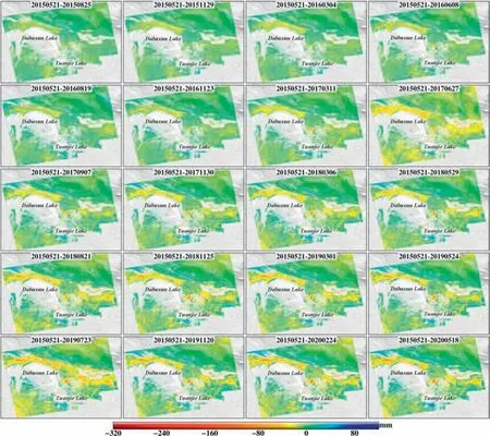
Fig.6.The cummulative deformations from May 2015 to May 2020,each subplot is plotted at about 3 months increments from the deformation results of SBAS-InSAR.
5.Discussion
5.1.Qinghai-Tibet railway
The length of Qinghai-Tibet railway is 120 km in the study area,and the railway passes through sand flat,salt lake area and alluvial fans.We plotted the deformation rate profile along the railway which is as shown in Fig.7.The profile represents the deformation rates of the intercepted CTs along the railway from P1 to P5 in the latest 5 years.As we can see from the deformation rate profile,the foundation of the railway in the sand flat from P1 to P2 is stable,and the deformation rate is within 5 mm/yr.But when the railway goes into the salt lake area,significant subsidence may affect the stability of the foundation.From P2 to P4,there has been an obvious discontinuity of uplift and subsidence.Especially in point P3,the subsidence rate has reached 20 mm/yr,which will be discussed in the section of brine exploitation and artificial construction.The discontinuity of uplift and subsidence also exist in the alluvial fans from P4 to P5.Due to the geological property of saline soil,the foundation of Qinghai-Tibet railway in the saline mud flat is much more unstable than that in the sand flat,and the discontinuity of uplift and subsidence is obvious.
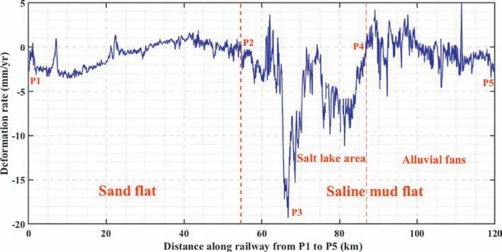
Fig.7.The profile of deformation rate along Qinghai-Tibet railway from P1 to P5.
Subsidence along the railway may be induced by the influence of dynamic load in railway transportation.In order to analyze the temporal characteristics of the deformation along the railway,we choose point P2 and T4 to present their time-series deformation from 2015 to 2020 which is shown in Fig.8.For Point P2,the deformation evolution is composed by seasonal deformation and general subsidence components.The manifestations of seasonal deformation are uplift from August to October,and subsidence from October to the next August.Meanwhile,there is an accelerated subsidence for P2 in the rainy season from May to August.For point T4,there is only a general subsidence trend but without accelerated subsidence in the rainy season.

Fig.5.The deformation rates from May 2015 to May 2020,and the specific divisions are(a)saline mud flat closed to the Dabuxun-HuobuxunLake Fault(the black dotted line from the northwest to the southeast in the middle of the study area),(b)saline mud flat with many rivers and(c)Qinghai-Tibet railway with human activities in the study area.Points T1-T8 represent the independent feature points,and points P1-P7are used to draw the profile lines in the follow sections,P1-P5 are located on the railway line.
Generally,the subsidence may be caused by the dynamic load of train movement between P2 and T4.P2 is far away from the lakes and rivers,so it is less affected by the surface water than other points.The precipitation and temperature may be the main factor that influence the surface dynamic evolution of saline soil.As mentioned in the previous section,saline soil has the typical properties of salt swelling and collapsibility.In the rainy season,the saline soil is easy to dissolve in water that accelerates the subsidence of P2.After the rainy season,due to the high temperature and intense evaporation in summer,salt swelling causes the uplift of P2 and T4.It is worth mentioning that there is no accelerated subsidence in the rainy seasons for point T4.Considering the location of T4 is in the middle of Dabuxun lake and Tuanjie lake,the main reason should be the increased hydraulic head in the water recharge process [7].
5.2.Brine exploitation and artificial construction
The deformation rates from May 2015 to May 2020 in Fig.5 show that there are many subsidence areas in the salt lake region.Especially in the areas around T3 and P3,the maximum subsidence rate reaches 50 mm/yr.As shown in Fig.9,both of them have a general subsidence trend that the cumulative deformations have reached to 150 mm in the latest 5 years.However,there is a stable period during each rainy season.As we can see from the satellite image in the upper right subplot of Fig.9,there are many drilling wells of the underground brine on both sides of T3,we suspect that the artificial exploitation of brine may be the main reason of subsidence for the salt mining area around T3.Additionally,since the area around P3 is the Dabuxun railway station,its general subsidence trend is possibly because of artificial construction and extraction of underground water for industrial and civil use.Considering T3 and P3 are closed to Dabuxun lake,they are both affected by the hydrodynamic system.Firstly,the precipitation and melt water from Kunlun mountain induce the lake flooding during the rainy seasons.Then the increased hydraulic head in the water recharge process causes the uplift.As a result,despite artificial exploitation of brine and groundwater,the areas aroundT3 and P3 are stable during the rainy seasons.
5.3.Natural geological environment
In the study area,there are two subregions under natural geological environment,one of them is on both sides of Dabuxun-Huobuxun Lake Fault,another one is in the alluvial fans.As shown in Fig.5,these two subregions are presented by the black dotted box (a) and (b) respectively.The deformation rate profile in Fig.10 reflects the deformation characteristics detailly.There are opposite deformation trends existed on both sides of Dabuxun-Huobuxun Lake Fault.One of them is uplift in the north and another is subsidence closed to the lake in the south.The different deformation trends indicate that the embedded faults may disrupt the groundwater flow and partition the hydrological units [7].In addition,the fault may have an extrusion activity in the latest 5 years,that induces the continuous uplift trend.
In Fig.11,points T1 and T2 are located in the northern and southern part of Dabuxun-Huobuxun Lake Fault respectively.There is a general uplift trend in point T1 while a general subsidence trend in point T2,which may be driven by the creep of the compression-shear thrust fault [49].Considering there is no surface runoff in this area,the seasonal dynamic evolution of saline soil is mainly driven by the meteorological condition.As a result,they both have a sharply subsidence trend by the salt collapsibility in rainy seasons;while in the dry seasons,they both have an uplift trend by the salt swelling or frost heave.
The runoffs directly influence the dynamic evolution of saline soil in the alluvial fans.Therefore,the uplift trend in the areas closed to the water and alluvial fans is possibly because of the upstream material migration and accumulation,but also solid salt crystals precipitated out of salt water [12,13].Accordingly,the areas around T5,T6 are mostly uplift,as shown in Fig.12.But the areas in the saline mud flat away from the water are mostly affected by the meteorological changes with seasonal subsidence,it can be presented by the deformation characteristics of points T7 and T8 in Fig.12.The deformation mechanism of point T7 and T8 is similar to point P2 which has been stated in the previous section.
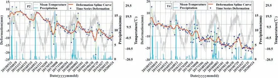
Fig.8.The time-series deformation of point P2 and T4 on the railway.

Fig.9.The time-series deformation and satellite images of point T3 and P3 in the saltpan and Dabuxun railway station.

Fig.10.The deformation rate profile crossing Dabuxun-Huobuxun Lake Fault from P6 to P7.
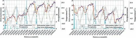
Fig.11.The time-series deformation of point T1 and T2 on both sides of the Dabuxun-HuobuxunLake Fault.

Fig.12.The time-series deformation and satellite images of point T5,T6,T7 and T8 in the areas with dense surface runoffs and alluvial fans.
6.Conclusion
To avoid the risk of potential engineering geological disasters induced by saline soil,the Qarhan Salt Lake region was selected as a typical study area,where the time-series deformation was extracted by SBAS-InSAR based on Sentinel-1A image data from 2015 to 2020.Subsequently,this study analysed the time series deformation characteristics of saline soil,and the influence ofthe external environmental factors including precipitation,temperature,hydrogeology,human activities and engineering geological characteristics of saline soil.Furthermore,the deformation mechanism of saline soil was interpreted according to the effects of human activities and natural environment,respectively.This study obtained the following three main conclusions.
Above all,many uneven subsidence areas were detected along Qinghai-Tibet railway in the Qarhan Salt Lake region.Because of different deformation trends existed between the adjacent areas,the discontinuity of uplift and subsidence was very obvious.Moreover,this phenomenon may affect the safety of the railway.
For the areas influenced by brine exploitation and artificial construction,a general subsidence trend was the common feature of these areas and accelerated in the rainy seasons from May to August every year.Under the influence of human activities,there were many severe subsidence areas.The maximum subsidence rate in this region reached 50 mm/yr,and the maximum cumulative subsidence exceeded 320 mm in the latest 5 years.In addition,the areas closed to the lakes were influenced by the hydraulic head changes significantly.The subsidence and rebound deformation of the ground was closely related to water discharge and recharge in the underground aquifer.
For the areas not affected by human activities,the dynamics of saline soil were relevant to the meteorological changes,surface water erosion and material migration.There was a continuous uplift trend in the saline mud flat closed to the rivers or lakes,but an obvious seasonal deformation characteristic was presented in those areas far away from the waterbody.In rainy seasons,there was a sharply subsidence trend caused by the salt collapsibility;while in dry seasons,an uplift trend caused by the salt swelling or frost heave appeared.
In general,hydraulic head changes,salt swelling,salt collapsibility,meteorological changes and human activities are the main factors that influence the stability of the ground foundation.Finding out the deformation characteristics and mechanism would contribute to the construction of large-scale infrastructure in saline soil areas.
Conflicts of interest
The authors declare that there is no conflicts of interest.
Acknowledgements
This research was jointly funded by the National Key R&D Program of China (Grant No.2017YFB0502700);the National Natural Science Foundation of China (Grant No.41771402,41804009,42071410);the Scientific R&D Plan of China Railway Corporation(No.JXKT-1801-2-2-7,P2018G004);and theSichuanScience and Technology Support Project (No.2018JY0664,20YYJC4292,2020YJ0322).The Sentinel-1A TOPS IW SLC SAR images and the POD data were provided by the Copernicus Sentinel-1 Mission of ESA.We also thank NASA for providing the SRTM DEM data.
 Geodesy and Geodynamics2022年2期
- Geodesy and Geodynamics的其它文章
- Analysis of terrestrial water storage changes in the Shaan-Gan-Ning Region using GPS and GRACE/GFO
- Ocean tide loading correction for InSAR measurements:Comparison of different ocean tide models
- A review of methods for mitigating ionospheric artifacts in differential SAR interferometry
- Co-and post-seismic slip analysis of the 2017 MW7.3 Sarpol Zahab earthquake using Sentinel-1 data
- Monitoring landslide associated with reservoir impoundment using synthetic aperture radar interferometry:A case study of the Yalong reservoir
- Review of the SBAS InSAR Time-series algorithms,applications,and challenges