Structure and formation of the South Yellow Sea water mass in the spring of 2007*
Xinyuan DIAO , Guangcheng SI , Chuanjie WEI , Fei YU ,5,**
1 Institute of Oceanology, Chinese Academy of Sciences, Qingdao 266071, China
2 Center for Ocean Mega-Science, Chinese Academy of Sciences, Qingdao 266071, China
3 Key Laboratory of Ocean Circulation and Waves, Chinese Academy of Sciences, Qingdao 266071, China
4 University of Chinese Academy of Sciences, Beijing 100049, China
5 Laboratory for Ocean and Climate Dynamics, Pilot National Laboratory for Marine Science and Technology (Qingdao),Qingdao 266237, China
Abstract Data obtained from over 250 CTD stations in December 2006 and April 2007 were used to analyze the temperature and salinity structure of the water masses of the South Yellow Sea in spring.Six basic water masses were identif ied: the Southwest Yellow Sea Coastal Water Mass (SWYSCWM),Southwest Yellow Sea Local Water Mass (SWYSLWM), Qingdao Cold Water Mass (QDCWM), Yellow Sea Warm Current Water Mass (YSWCWM), Inchon Cold Water Mass (ICWM), and Subei Coastal Water Mass (SBCWM). The mechanisms of formation of these water masses are very diff erent. The SWYSCWM is aff ected by continental water, whereas the SWYSLWM and SBCWM are local water masses that are less aff ected by other waters. The QDCWM derives from cold northern water. The YSWCWM exists from winter to spring. Because of the limited data coverage, the mechanism of formation of the ICWM remains unclear.
Keyword: Yellow Sea; spring; water mass; formation
1 INTRODUCTION
The Yellow Sea (YS) is a semi-closed shelf region between China and the Korean peninsula. It is connected to the Bohai Sea in the north and the East China Sea in the south. There is a trough in the middle of the YS with a maximum depth of about 90 m,which shallows to less than 20 m within 50 km of the coasts. The trough extends from the southeast to the north, and the isobaths are aligned almost parallel to the coastline. To the east of the trough, the isobaths are concentrated, whereas the western slope is gentler.The Subei shoal is a very broad area in the southwest of the YS where the water depth is mostly <20 m.
The most typical water mass structures in the YS are the Yellow Sea Warm Current (YSWC) in winter and the Yellow Sea Cold Water Mass (YSCWM) in summer. The YSWC was f irst suggested by Uda(1934, 1936) based on hydrographic data and trajectories of drift bottles. The main characteristic of the YSWC is that it transports warm saline water from the Tsushima Warm Current to the YS. However,Nitani (1972) and Hsueh (1988) also suggested that the YSWC might f low northward along the trough in the central YS. Teague and Jacobs (2000) found evidence that the YSWC exists in summer and concluded that this is because of the weak southerly wind. Based on data from direct current observations,Yu et al. (2010) proposed that the YSWC is strong in the bottom layers and weak at the surface. Using satellite-derived sea surface height and wind data,Zhao et al. (2011) identif ied two branches in the YSWC path that were considered the result of the diff erent sea surface heights driving the current.
Ho et al. (1959) used three-layer temperature (T)and salinity (S) data to describe the shape and formation of the YSCWM, which was considered the result of residual cold winter water. This work was corroborated by Kwan (1963) and Nakao (1977) who achieved similar results. Using a progressiveT-Smethod, Mao et al. (1964) revealed the details of three basic water masses (Continent Shelf Water, Mixed Yellow Sea Local Water, and Kuroshio Water). Zheng and Zhang (1983), Qiu et al. (1984), Li et al. (1989),Zhao et al. (1991), and Zhang et al. (1996) used familiar methods to analyze the water masses in the YS. Using various data, the water masses were identif ied by shape, position, and strength. Zheng and Zhang (1983) described seven water masses in the YS: the Coastal Yellow Sea Water Mass (CYSWM),Yellow Sea Local Water Mass (YSLWM), South Yellow Sea Warm Surface Water Mass (SYSWSWM),South Yellow Sea Cold Water Mass (SYSCWM),North Yellow Sea Cold Water Mass (NYSCWM), and Qingdao Cold Water Mass (QDCWM). Five of these were mentioned by Qiu et al. (1984), who combined the SYSCWM and NYSCWM into the YSCWM and added continental dilution (from the Yalu River and Changjiang (Yangtze) River). Li et al. (1989)identif ied 11 water masses, which included those above together with the Mixed Yellow Sea-East China Sea Water Mass, Surface East China Sea Water Mass,and Subsurface East China Sea Water Mass.
With the acknowledgement of the existence of the YSCWM, there has been increasing research into the internal structures of the YS water masses. Zhao et al.(1991) was the f irst to recognize that the warm water in the middle of the YSCWM in spring was residual water from the wintertime YSWC. Zhang et al. (1994)extended the study to eastern coastal areas and found the West Korea Shelf Cold Water. Using data from the China-South Korea operational cruises, Tang et al.(1999) analyzed the hydrological characteristics and circulation of the YS in spring, and suggested the axis of YSWC tongue turned east and the middle layer cold water appeared in some region of the YS. Zhang et al. (1996, 2002, 2004) showed that the QDCWM appeared in March, stabilized in April, strengthened in May, weakened in June, and disappeared in July with a period of interannual variation associated with El Nino-Southern Oscillation (ENSO). It was concluded that the formation of the QDCWM is related to the southern f low of the Chengshantou Cold Water Mass instead of local water and that its strength is related to the winter air temperature of the northern area of the Shandong Peninsula. However, the QDCWM is not a part of the YSCWM. Zou et al.(2000, 2001) indicated that the Middle Layer Cold Water Mass to the south of Chengshantou has the same life period and location as the QDCWM;however, it was concluded that its formation is related to the force of the warm surface temperature and YSWC. Yu et al. (2005) highlighted that the Middle Layer Cold Water Mass and QDCWM exist at the same time in diff erent locations, and that a cold water mass appears in the east of the South YS.
Although much research has been conducted on the structure and mechanisms of formation of the YSWC and YSCWM, the dynamic processes and hydrological characteristics in spring are often ignored. However, it is exactly the currents and hydrological processes in spring that lead to the changes in the ocean structure in summer. To obtain better understanding of the phenomena in the South YS, two cruises were undertaken in December 2006 and April 2007. Based on the obtained data, it is suggested here that there are six water masses (the Southwest Yellow Sea Coastal Water Mass(SWYSCWM), Southwest Yellow Sea Local Water Mass (SWYSLWM), Qingdao Cold Water Mass(QDCWM), Yellow Sea Warm Current Water Mass(YSWCWM), Inchon Cold Water Mass (ICWM), and Subei Coastal Water Mass (SBCWM)) in the southwest YS in spring. Because insuffi cient data can be covered to investigate the ICWM, the mechanisms of formation of the other f ive water masses is discussed by using the sea surface temperature (SST)data.
2 DATA AND METHOD
In December 2006 and April 2007, Sea-Bird Scientif ic SBE911plus CTD data were obtained from 250 CTD stations to investigate the structure of the South YS. The locations of the stations are shown in Fig.1. The spatial interval between the CTD data for the two cruises was 15 nautical miles in longitude and 20 nautical miles in latitude. The accuracies of the temperature and conductivity measurements were±0.001 °C and ±0.000 3 S/m, respectively. The sampling rate was 24 Hz, and after data quality and f iltering processes, the vertical resolution was 1 m.
Based on the obtained data, contours of temperature and salinity in both horizontal and vertical directions along latitudinal sections were constructed for the analysis. Furthermore, the classicalT-Smethod was used to distinguish the individual water masses within the region. To study the formation of these water masses, the diff erences between the temperature and salinity data in spring and winter were identif ied and reasons for the diff erences were also analyzed.
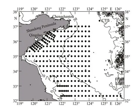
Fig.1 Locations of the CTD stations
Two moored systems were deployed in May and June 2014 to investigate the currents of the South YS in spring (Fig.2). The locations, depths, and deployment times are shown in Table 1. A Sea-Bird Scientif ic HydroCAT CTD system (temperature,conductivity, and optical oxygen sensors) and a Teledyne RD Instruments 300-kHz acoustic Doppler current prof iler were installed in the mooring system.The sample interval of the acoustic Doppler current prof iler was 30 min and the vertical resolution was 2 m. The Lanczos cosine f ilter method was used to remove tidal signals with periods of 2-3 days. The residual f low was analyzed to ref lect the current in the South YS in spring.
3 IDENTIFICATION OF WATER MASSES AND THEIR PROPERTIES
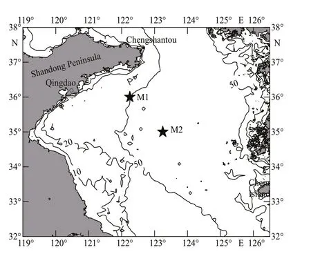
Fig.2 Moored stations in May and June 2014

Table 1 Moored stations in May and June 2014
During spring, the water temperature of the YS gradually increases to summer-type levels. However,the temperature and salinity structure of the YS diff ers markedly between spring and winter, especially in the bottom layer (Figs.3c, 3f, 4c, & 4f). Although the warm water tongue of the YSWC extends into the YS in the bottom layer in spring (Fig.3c & f), the front of the tongue is weaker, and it deviates to the east. At the same time, the less saline and cold water from the Shandong Peninsula coast stretches further south in the middle layer in spring (Fig.3b & e) than in winter(Fig.4b & e). In particular, nearshore shallow water warms at a faster rate than central areas of the YS.The temperature increase is particularly obvious to the south of northern Jiangsu, where it is up to 13.0 °C and signif icantly higher than the off shore water temperature (Fig.3a). These phenomena cause large changes to the distribution of isotherms in the coastal area. In the region north of 34°N, the isotherms are aligned almost in latitude, and there is a similar pattern in the 30-m layer (Fig.3b). Furthermore, it should be noted that in the less saline cold water tongue stretching to the south, there is a closed cold water area around 36°N, 122°15E. The central temperature of this area is <8.0 °C (Fig.3a). The bottom-layer temperature distribution is almost the same as the surface layer (Fig.3c). The temperature in the warm water tongue from Jeju Island is >12.0 °C,whereas the temperature in the central area of the less saline cold water tongue from the Shandong coastal area is <2.0 °C.
The surface distribution of salinity in spring has signif icant diff erences to winter. The saline tongue from Cheju Island still exists, but the salinity in central areas decreases from 34.0 to 33.5 (Figs.3d &4d). Furthermore, it is separated into two tongues: one pointing north and the other less saline tongue pointing to the off shore area of Qingdao (Fig.3d).This is because the northwest branch of the YSWC withers away in April and the north branch axis turns east (Zhao, 2011). This, in turn, allows the Shandong coastal low-salinity cold water to stretch southward(Fig.3d & e). Meanwhile, off the coast north of the Sheyang River estuary, the tongue of water with low salinity (lowest values <29.0) is found to extend to the northeast (Fig.3d & f). Because of the expansion of the area of low-salinity water due to the increase in runoff from the Changjiang River estuary, it begins tomix with the low-salinity water extending southward from northern Jiangsu. In the 30-m layer, an isolated block of high salinity water (values up to 34.0) is found within the highly saline waters of the midocean area (Fig.3e). The salinity contour of the bottom layer exhibits a closed shape, except for the coastal low-salinity area (Fig.3f). The salinity in this layer decreases from 34.0 in the middle of the YS to less than 32.0 in the coastal regions (Fig.4f). The lowest value of salinity (<29.0) appears in the Subei coastal area, outside the Sheyang River estuary. However,there is a strong salinity front between the high and low-salinity waters.
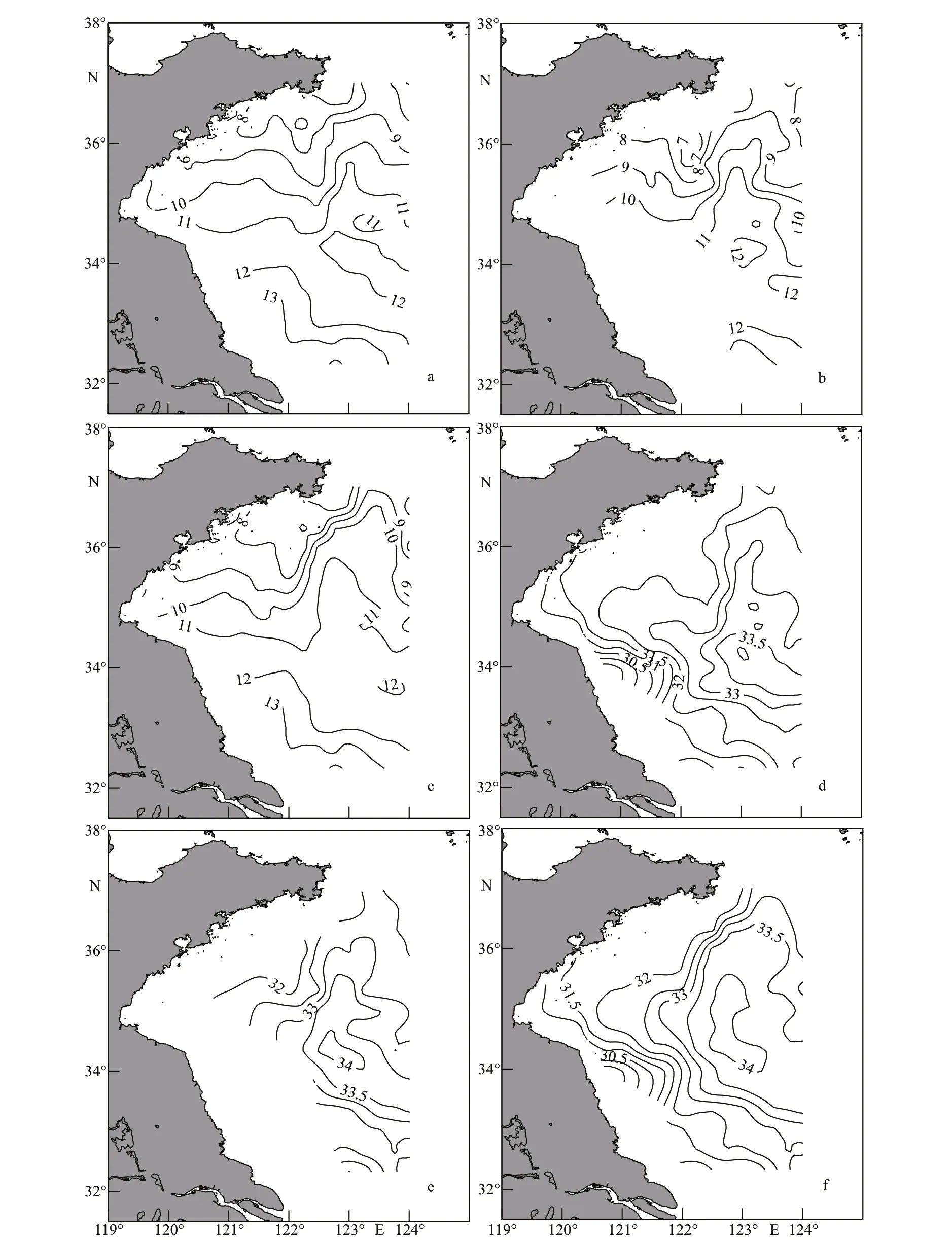
Fig.3 Springtime horizontal distribution of surface temperature (a), 30-m temperature (b), bottom temperature (c), surface salinity (d), 20-m salinity (e), and bottom salinity (f)
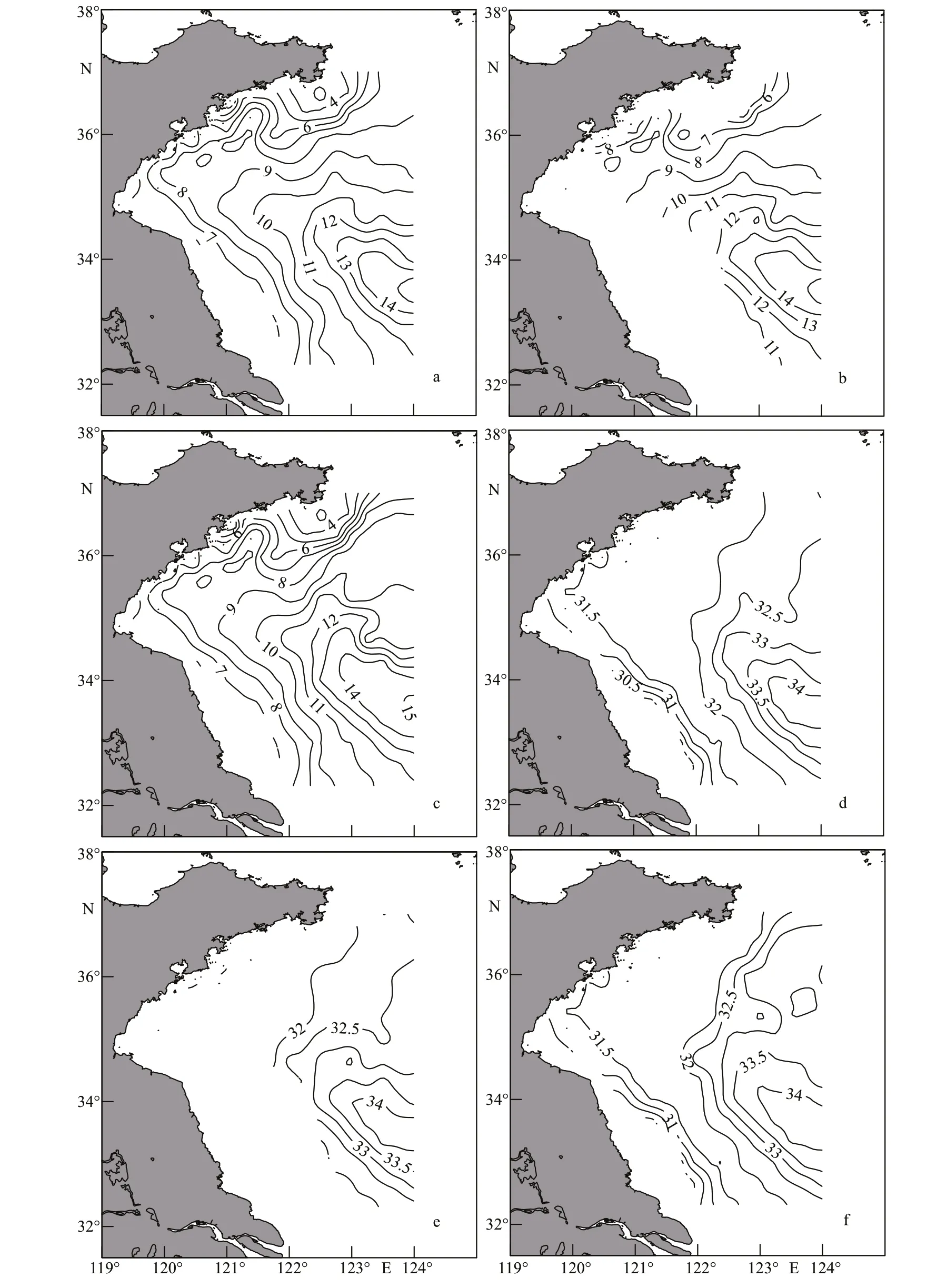
Fig.4 Wintertime horizontal distribution of surface temperature (a), 30-m temperature (b), bottom temperature (c), surface salinity (d), 20-m salinity (e), and bottom salinity (f)
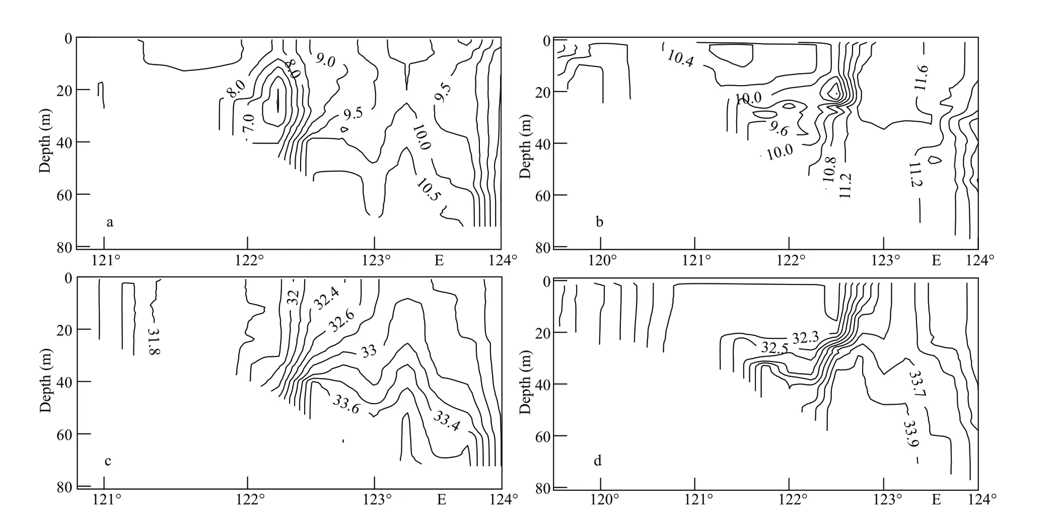
Fig.5 Summertime vertical distributions of temperature (unit: ℃) at 36°N (a), 35°N (b) and salinity at 36°N (c), 35°N (d)
Because the investigation was performed in April,the eff ect of solar radiation heating the ocean surface is clear. In the 35°N and 36°N sections, the surface temperatures are much higher than in winter(Figs.5a-b & 6a-b). Noticeably, there is a layer of cold water in the middle of the two sections. Its center is at 122°25′E and its width is about 100 km. In particular, over the depth range of 15-35 m, the 7.0 °C isotherm is almost closed and the temperature in the center is <6.0 °C at 36°N (Fig.5a); the corresponding temperatures are 10.0 °C and <9.0 °C at 35°N(Fig.5b). Furthermore, cold water appears in the YS trough, because the section ends at 124°E and thus,the complete pattern and center of this cold water are not shown. In the west of the YS trough, there is warm water from the bottom to the surface. The bottom temperature is 11.5 °C at 35°N and 10.5 °C at 36°N,which causes a strong ocean front around the warm water and clearly, the warm water is aff ected by the YSWC. Another area of cold water that cannot be ignored exists in the coastal area, although it is less cold than the other areas. It can be seen clearly at 36°N but has much wider extent at 35°N.
A comparison of the structure of the temperature and salinity in 35°N and 36°N sections reveals diff erent features (Fig.5c & d). The most obvious pattern is the saline water to the west of the YS trough.The highest salinity at 36°N is up to 33.8 in the bottom water and 32.8 at the surface (corresponding values at 35°N are 34.0 and 33.6, respectively). This corresponds to the warm water at the same location,which is derived from the YSWC and has a salinity front around it. The same situation happens in the cold area, where the salinity is relatively low. Because salinity is unaff ected by air temperature, there is no thermocline in the surface layer. Compared with the winter situation, the warm and saline water in summer is rising up instead of staying at the bottom, especially at 36°N (Figs.5c & 6c).
A classicalT-Scurve method (Helland-Hansen,1916) was used to analyze the water masses in the South YS. In spring, f ive water masses are clearly distinguishable in theT-Scurve shown in Fig.7a: the Southwest Yellow Sea Coastal Water Mass(SWYSCWM, marked as A), Southwest Yellow Sea Local Water Mass (SWYSLWM, marked as B),Qingdao Cold Water Mass (QDCWM, marked as C),Yellow Sea Warm Current Water Mass (YSWCWM,marked as D), and Subei Coastal Water Mass(SBCWM, marked as E). However, in combination with the horizontal and vertical distributions of temperature and salinity, two water masses are located at the same position; these are the QDCWM and Inchon Cold Water Mass (ICWM) (Yu et al., 2005).Therefore, in spring, there are actually six water masses in the South YS, whereas the situation is much simpler in winter with just the SWYSCWM,SWYSLWM, and YSWC (Fig.7b).
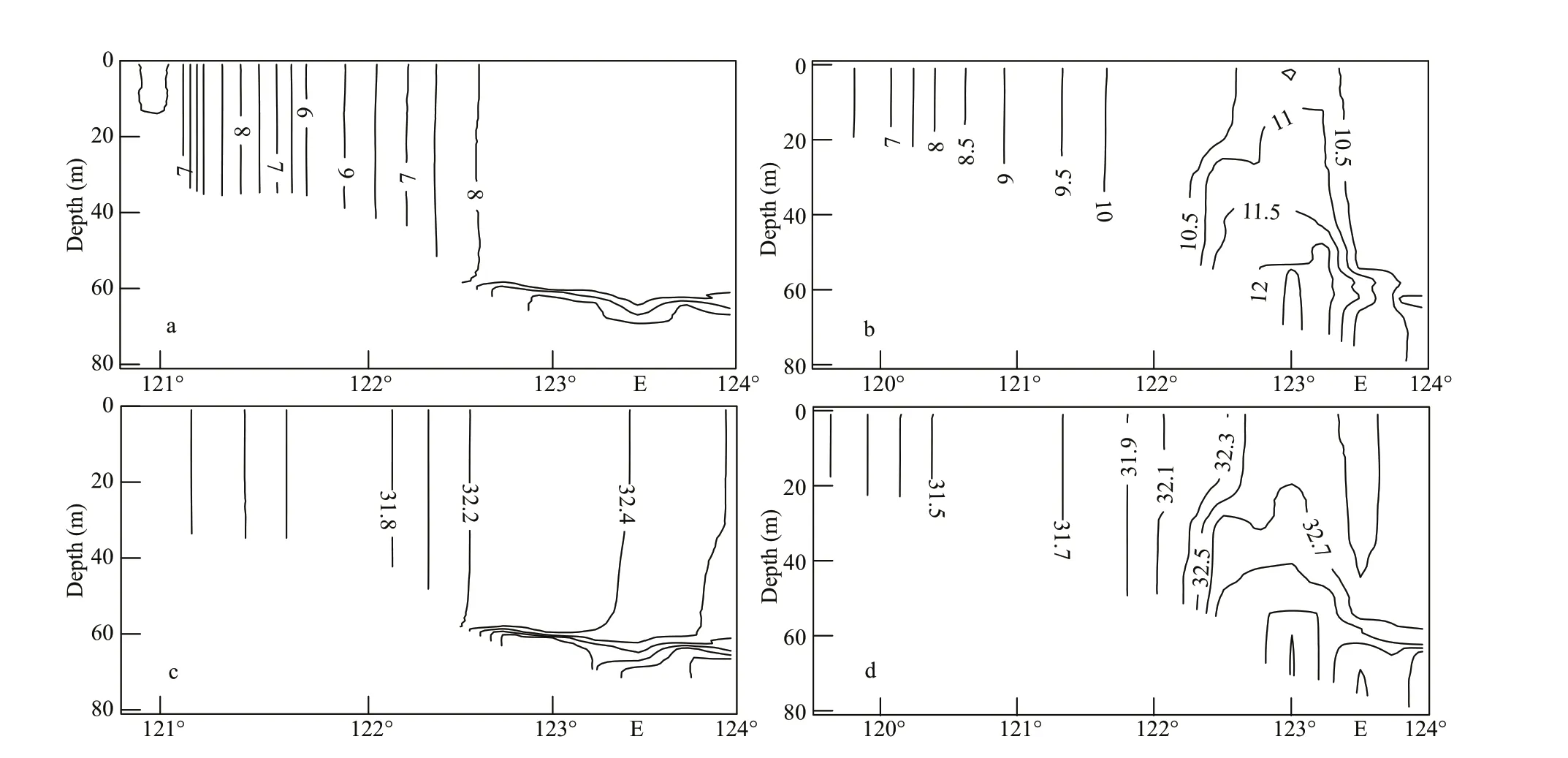
Fig.6 Wintertime vertical distributions of temperature (unit: ℃) at 36°N (a), 35°N (b) and salinity at 36°N (c), 35°N (d)
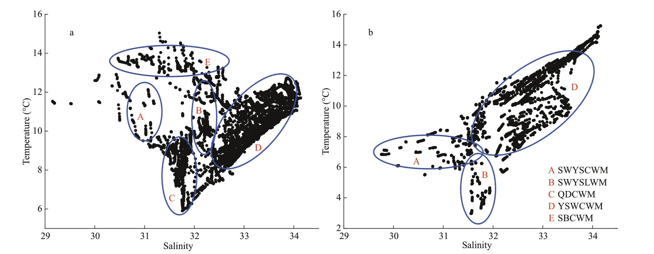
Fig.7 T- S curve in spring (a) and winter (b)
The horizontal distribution of the water mass is shown in Fig.8. The SWYSCWM is very close to the coastline covers the most area of the southwest YS and it extends from the bottom to the surface. The salinity and temperature of this water mass range from 30.5-31.2 (Fig.3d) and 9.0-12.0 °C, respectively(Fig.3a). It appears that this water mass is aff ected by continental water. The SWYSLWM lies between the SWYSCWM, SBCWM, and QDCWM, and it also extends from the bottom to the surface. Because it is less aff ected by the surrounding water masses, its salinity is around 32.2 and its temperature ranges from 10.0-13.0 °C. The QDCWM lies mainly in the area with a depth of about 40-60 m and it extends from the bottom to the middle layer. It has salinity of around 31.7 and temperature that range from 6.0 °C in the north to 10.0 °C in the south (Fig.3b & d). The northwest branch of the YSWC shrinks in comparison with its wintertime extent; it has salinity of around 33.0 and a temperature of around 11.0 °C. The north branch however remains tangible, occupying the western area of the YS trough; it has the second highest salinity of 32.5-34.0 and a temperature range of 8.0-12.0 °C. The SBCWM lies in the shallow Subei coastal area. Because of heating from the sun and the shallow depth of the water, the temperature rise here is the highest in the South YS, reaching 13.0-15.0 °C, although the salinity is only about 30.5-32.0. The highest values of salinity (34.5) and temperature (15.0 °C) were found in water that comes from the area near Cheju Island, which is the source of the YSWC.
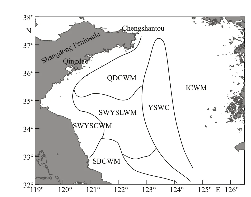
Fig.8 Horizontal distribution of the water masses of spring in 2007
4 FORMATION OF WATER MASSES
Because of the increase in air temperature and strengthening of the solar radiation in spring, sea surface temperature should clearly rise. This evidently occurs in the Subei coastal waters, but the situation is very diff erent in other regions.
At 35°40′N, the temperature of the SWYSCWM in spring is 0.5 °C higher than in winter (Fig.9a), and the salinity is 0.1 higher (Fig.9b). This can also be seen in theT-Scurve, in which the average temperature is 4.0 °C higher and the salinity is 1.0 higher. The rise in temperature apparently comes from spring warming,and the rise in salinity comes from the winter YSWC.The temperature of the SWYSLWM in spring is 2.0 °C higher than in winter and its salinity is 0.2 higher. The reason for this is the same as for the SWYSCWM. However, in the middle layer of the QDCWM, the temperature is reduced by 0.1 °C and the salinity increased by 0.1. This is due to the cold low-salinity Shandong Peninsula Coastal Water(Zhang et al., 2002), which stretches to the south.Because of the rising SST and the YSWC in the bottom layers, it has an intermediate density, which means it becomes the middle layer cold water.Through mixing with the local water, it becomes the QDCWM. The highest rise in temperature and salinity occurs in the YSWC area, with magnitudes of 2.0 °C and 1.5, respectively. It can be seen from Fig.9b that the YSWC still exists, especially in the bottom layer(the same pattern had shown in Yu et al. (2010)). Both temperature and salinity decrease in the ICWM area by 0.5 °C and 0.5. Unfortunately, the lack of data beyond 124°E means that the reasons for the reduction are not clear.
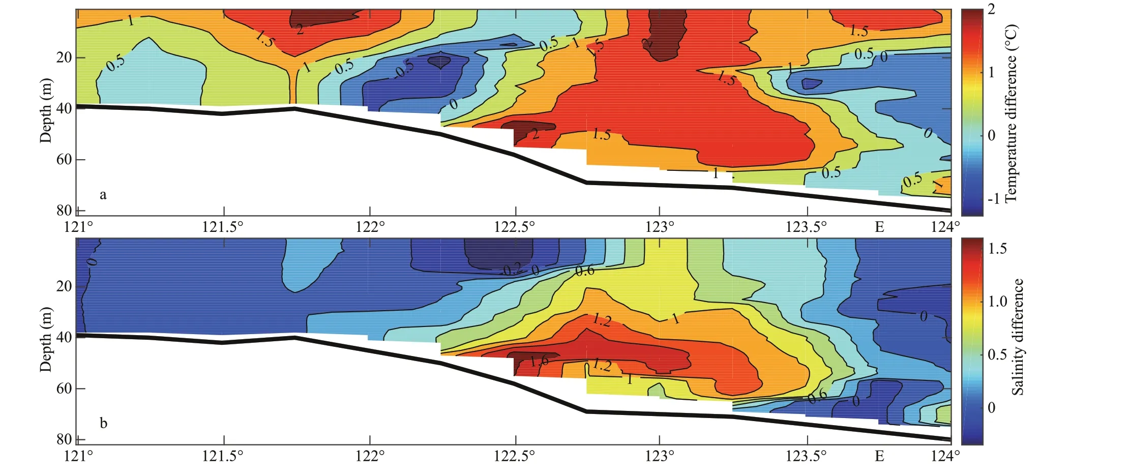
Fig.9 Diff erence from winter to spring of temperature (a) and salinity (b) at 35°40′N
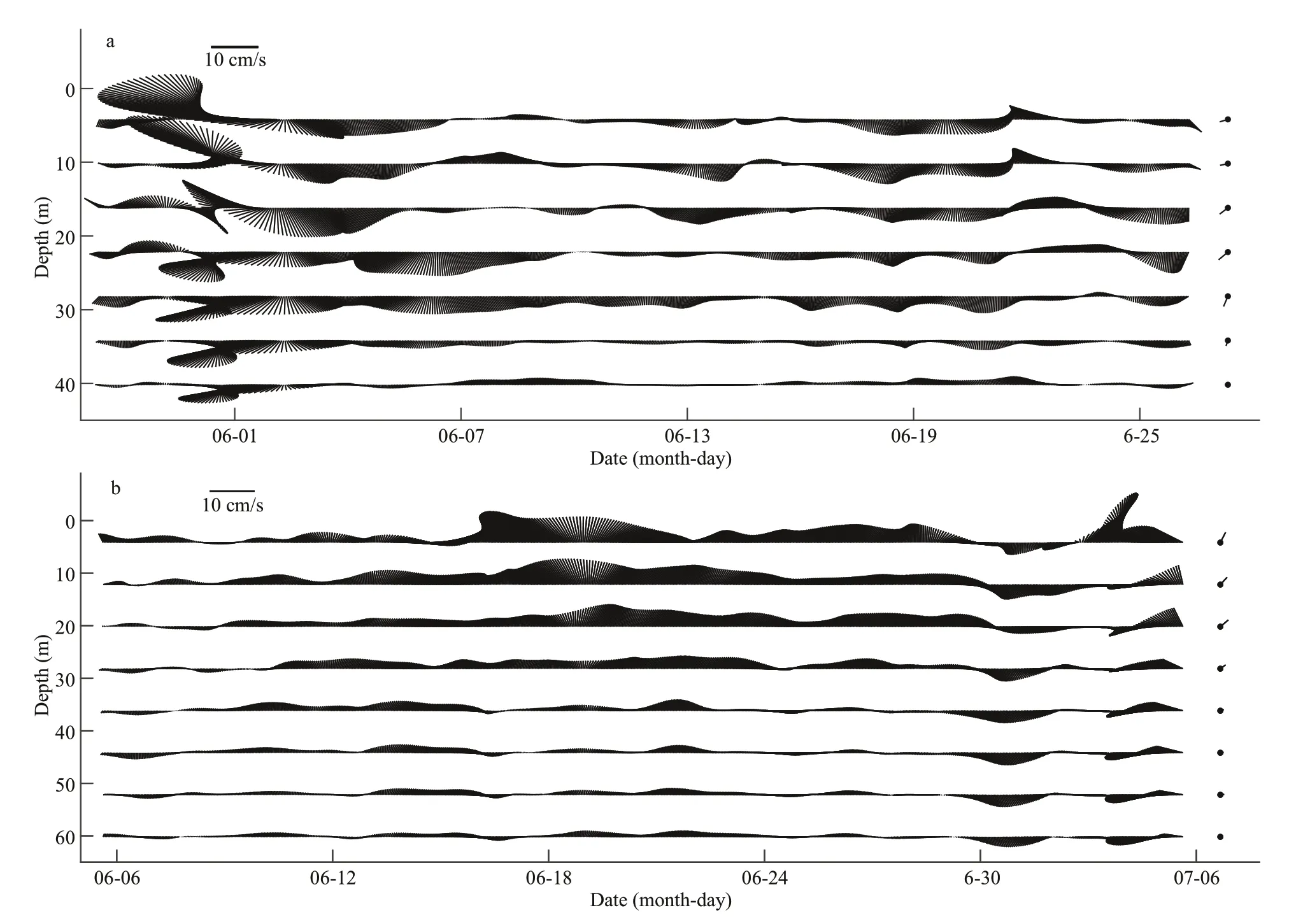
Fig.10 Residual current at station M1 (a) and M2 (b), and the vectors on the right are the mean over time
The residual current in the QDCWM area is almost in the southwest direction (Fig.10a). The magnitude of velocity is greatest (10 cm/s) in the middle, and smallest at the bottom, which f its the temperature structure of the 36°N section (Fig.5). This is why the cold water is in the middle layer in the QDCWM. The average magnitude of the velocity of the middle current in the investigation period is about 3-4 cm/s at M1 station. At station M2, the residual current is mainly in the northeast direction (Fig.10b). The magnitude of the velocity is greatest (15 cm/s) in the upper layer. The average magnitude of the velocity is about 5 cm/s in the upper layer and almost 0 cm/s in the bottom layer. This indicates the retreat of the YSWC in June and July. It is clear that two currents exist in the South YS in spring: one is the YSWC and the other is the f low from Chengshantou. The YSWC is mainly in the bottom layer, and it brings warm and salty water. The Chengshantou f low is mainly in the middle layer and it brings cold and low-salinity water.This is also well evidenced by the temperature and salinity in the bottom layer. At station M1, the temperature in the bottom layer remains stable until the end of June; however, at the same time, the salinity is reduced by about 0.1 during the investigation period(Fig.11a). This is apparently caused by the southward f low of cold and less salty Chengshantou water. At station M2, the temperature at the bottom continues to rise throughout the investigation period, and the magnitude of the rise is 0.4 °C (Fig.11b). Salinity displays the same trend with a magnitude of variation of 0.16, which is caused by the warm salty YSWC water.
5 CONCLUSION
Although many former researches discussed the water masses structure of the south YS, due to the spatial resolution of the data is not enough, some water masses like SWYSCWM and SWYSLWM was not mentioned before. With the high spatial resolution CTD data and long term mooring data, in spring, the temperature and salinity structure in the south YS shows the characteristics of the transition from winter to summer. Many particular patterns can be determined, which are outlined below.
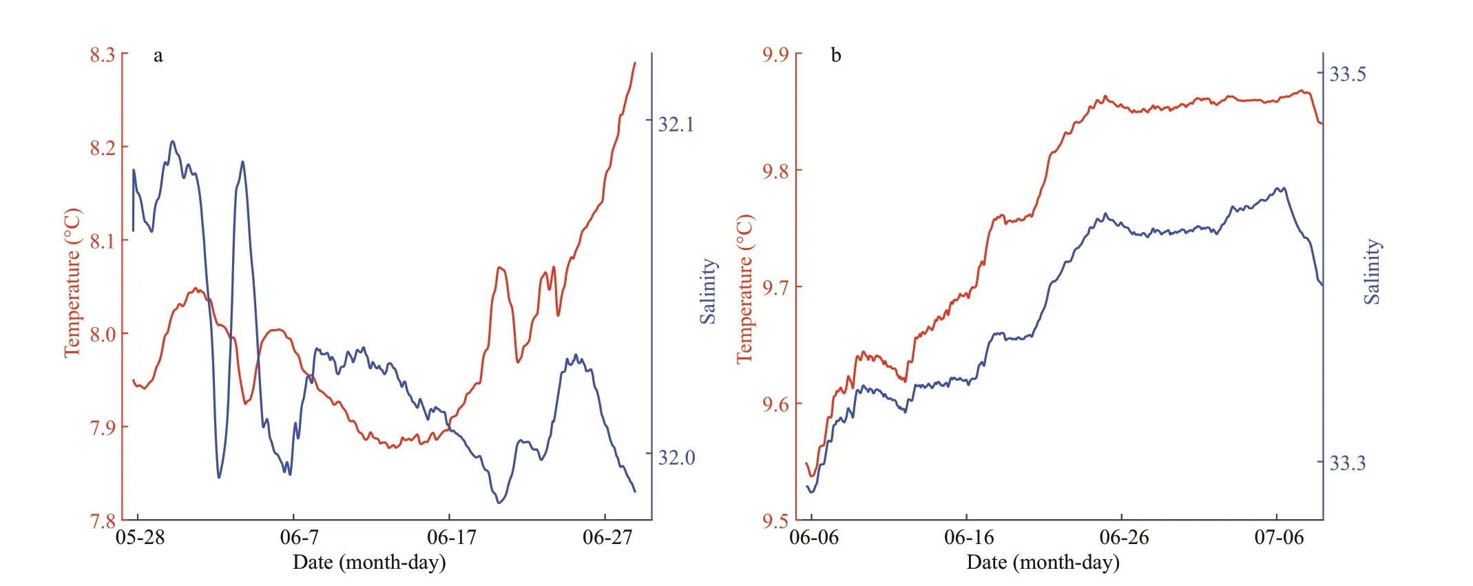
Fig.11 Bottom temperature and salinity at station M1 (a) and M2 (b)
(1) The YSWC still exists in the bottom layer in spring. Its northwest branch retreats and the axis of the north branch turns to the east. At the same time,cold and less saline water turns south from Chengshantou and stretches along the 50-m isobath.With the YSCWM below, it becomes the middle layer cold water and constitutes the QDCWM. In the Subei coastal area, because of its shallow depth, the temperature rises more quickly than in other places.
(2) There are six water masses in the south YS in spring: the SWYSCWM, SWYSLWM, QDCWM,YSWC, ICWM, and SBCWM. Of these, the QDCWM, YSWC, and ICWM constitute the YSCWM.
(3) The mechanisms of formation of these water masses are very diff erent. The SWYSCWM is aff ected by continental water, whereas the SWYSLWM and SBCWM are local water masses that are less aff ected by other waters. The QDCWM derives from cold northern water. The YSWC still exists. Because of the limited data coverage, the mechanism of formation of the ICWM remains unclear.
6 DATA AVAILABILITY STATEMENT
All data generated and analyzed during this study can be f ind at http://msdc.qdio.ac.cn/ with DOI of https://doi.org/10.12157/IOCAS.20210826.002 and https://doi.org/10.12157/IOCAS.20210826.001.
 Journal of Oceanology and Limnology2022年1期
- Journal of Oceanology and Limnology的其它文章
- The adjoint-based Two Oceans One Sea State Estimate(TOOSSE)*
- Lagrangian eddies in the Northwestern Pacif ic Ocean*
- Seasonal variability in dissolved oxygen in the Bohai Sea,China*
- In-situ experiments reveal mineralization details of porphyry copper deposits
- Chemical composition and Pb(II) binding of dissolved organic matter in a hypersaline lake in China*
- Characterization of dissolved organic matter in submarine groundwater from a salt marsh in Chongming Island, China*
