
Changes in morphology and soil nutrient patterns of nebkhas in arid regions along a precipitation gradient
2021-07-30 01:12WeiChengLuoWenZhiZhaoBingLiuHengRen
WeiCheng Luo,WenZhi Zhao,Bing Liu,Heng Ren
Linze Inland River Basin Research Station,Chinese Ecosystem Research Network,Key Laboratory of Ecohydrology of Inland River Basin,Northwest Institute of Eco-Environment and Resources,Chinese Academy of Sciences,Lanzhou,Gansu 730000,China
ABSTRACT Nebkhas,discrete mounds of sand and vegetation,are a common landscape feature critical to the stability of desert ecosys‐tems and supported by limited precipitation.Nebkha morphology and spatial pattern vary in landscapes,but it is unclear how they change along precipitation gradients in arid and semi-arid regions.In this study we determined morphology and soil nutrient patterns of nebkha from different regions of northwestern China.The objective of this study was to under‐stand zonal differences among nebkhas and how morphological characteristics and soil nutrient patterns of nebkha change along a precipitation gradient in northwestern China.Our results shows that mean annual precipitation(MAP)had signifi‐cant effects on morphological characteristics of nebkhas such as height,area,and volume which significantly decreased with an increase in MAP.MAP had significant positive effects on shrub cover and species richness of nebkha.Soil nutri‐ents such as soil organic matter (SOM),total carbon (TC),total nitrogen (TN),and total phosphorus (TP) in the 0−10 cm layer increased with an increase of MAP,and soil nutrient content within nebkhas was higher than in inter-nebkha areas.We concluded that nebkhas are "fertile islands" with an important role in ecosystem dynamics in study regions.Further,MAP is a key factor which determined zonal differences,morphological,and soil nutrients patterns of nebkhas.However,disturbance,such as animal grazing,and planted sand-stabilizing vegetation accelerated the degeneration of nebkha landscapes.We recommend implementation of protective measures for nebkhas in arid and semi-arid areas of China.
Keywords:Nebkha;morphology;soil nutrient;precipitation gradient;arid and semi-arid lands
1 Introduction
Nebkhas,or sand mounds supporting burial-toler‐ant desert plants,play an important role in sustaining bio-diversity in coastal and desert areas.They occur in arid and semi-arid areas all over the word,and are common in arid coastal ecosystems (El-Banaet al.,2002),desert ecosystems (Quetset al.,2016),degrad‐ed rangelands,and farmlands (El-Banaet al.,2003;Wanget al.,2006).Nebkhas limit desert expansion because they trap windborne sediment (Hesp and McLachlan,2000;Quetset al.,2016),increase soil surface roughness (Kinget al.,2006),and restrict eo‐lian sediment flux above the landscape (Danin,1996;Okinet al.,2006).This is also why nebkhas are rec‐ommended for restoration of degraded rangelands(El-Banaet al.,2003).Further,nebkhas provide a favor‐able micro-environment for some soil animals,and form "fertile islands" for herbaceous plants (Hesp and McLachlan,2000;Tituset al.,2002).
The morphology of nebkha host plants and the source of sand are two of the most important factors which determine the development of nekbhas (Hesp and McLachlan,2000).Thus,plants with a prostrate growth habit form low,semi-circular nebkha mounds,while plants with vertical,dense,and multi-branching growth habit form tall,narrow,and conical-to-ellipti‐cal nebkha mounds (Hesp and McLachlan,2000).Other factors,such as climate,human activities,to‐pography,and hydrologic processes also have impor‐tant effects on the formation and development of neb‐khas because they contribute to the growth and devel‐opment of nebkha host plants (Khalafet al.,2014;Quetset al.,2016).For example,spatial variability in nebkha growth is driven by water availability because the bulk of precipitation in deserts is redistributed to topographic lows;nebkhas grow well in topographic depressions and decline in topographic highs (Quetset al.,2016).
In water limited systems,soil water is the domi‐nant controlling factor for plant growth and develop‐ment (Noy-Meir,1973;Touchetteet al.,2012).Thus,soil water determines vegetation and landscape pat‐terns in arid and semi-arid regions (Schwinninget al.,2005).Previous studies have shown that soil water has an important effect on the survival and develop‐ment of nebkhas (Yanget al.,2014).On one hand,soil water availability controls the growth and shrink‐ing of nebkhas because soil water directly determines the growth and survival of nebkha host plants (Quetset al.,2016).On the other hand,soil water conditions drive the spatial variability in nebkha growth because soil water controls vegetation cover and indirectly de‐termines sand sources and wind conditions which greatly influence nebkha morphology (El-Banaet al.,2007;Hesp and Smyth,2019).
Precipitation is the primary water source in water limited systems (Schwinninget al.,2005),and a change in precipitation amount affects both the spatial and temporal water availability,and potentially alters the structure and function of both abiotic and biotic(Tomioloet al.,2015;Zhanget al.,2018).Changes in precipitation patterns can also change the diversity,functional composition,and primary productivity of plant communities (Hookeret al.,2008).Precipitation patterns are among the most important drivers of spa‐tial and self-organization patterns of nebkhas because precipitation patterns affect the survival of nebkha host plants (Quetset al.,2016);factors such as sand resources,wind conditions,topography,and plant growth characteristics all have important influence on nebkha morphology,microclimate,and habitat ecolo‐gy (Hesp and McLachlan,2000;El-Banaet al.,2007;Hesp and Smyth,2019).However,it is still unclear how nebkha spatial patterns change along precipita‐tion gradients in arid and semi-arid regions.
Nebkha landscape is widely distributed in north‐western China,where it is an important ecological barrier around oases.Nebkhas not only intercept most of the sand transported from dune areas to oases by wind,but also contribute to restoration of transition areas between oases and deserts (Luoet al.,2016;Luo and Zhao,2019).Our preliminary field investiga‐tion revealed that the spatial distribution and morpho‐logical characteristics of nebkhas significantly dif‐fered in space.For example,Nitraria sphaerocarpanebkhas at the edge of Badain Jaran Desert are small and continuous.However,N.sphaerocarpanebkhas in Mu Us Sandland are large and distributed in patch‐es (Zhouet al.,2015;Luoet al.,2016).This indicates that spatial differences in morphological characteris‐tics and spatial patterns of nebkhas are significant.Earlier studies in these regions focused on spatial dis‐tribution,morphological characteristics (Luoet al.,2016),species composition (Zhouet al.,2015;Luoet al.,2016),soil nutrient accumulation,and soil micro‐biological properties (Caoet al.,2016) of nebkhas,but it is largely unknown which factors drive zonal differences in nebkha and its internal mechanisms.
Recent human activities,such as overgrazing and farmland reclamation,have led to the degradation of nebkhas,and this resulted in a new source of sand in northwestern China (Luo and Zhao,2019).Thus,pro‐tection of nebkhas,in particular maintenance of vege‐tation diversity,became important to the stabilization of ecological environment in arid and semi-arid areas.One important basis of nebkha protection is a thor‐ough understanding of nebkhas zonal differences and internal mechanisms.Therefore,to provide scientific basis for the protection of nebkhas in northwestern China,we aimed to answer the following questions in this study:(1) what are the zonal differences in neb‐khas in different areas of northwestern China and (2)how do morphological characteristics and soil nutri‐ent patterns of nebkhas change along a precipitation gradient?
2 Methods
2.1 Study site
Our study was conducted in two typical sandy ar‐eas in northwestern China,the Mu Us and the Hexi Sandland,which range in climate from semi-arid to extremely arid(Figure 1).
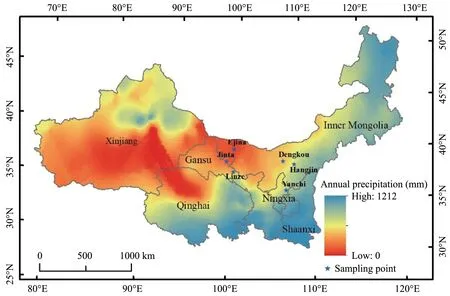
Figure 1 Distribution of sampling sites(stars)along a precipitation gradient in northwestern China
The Mu Us Sandland is located in north-central China (37°30′N to 39°20′N,107°20′E to 111°30′ E).The climate of this area ranges from semi-arid to arid,with mean annual precipitation of 345 mm,of which 60%−75% occurs as rain from June to September(Zhouet al.,2019).Mean annual temperature is 7 °C,and mean annual pan evaporation is about 2,200 mm.Some drought-tolerance plants such asArtemisia or‐dosicaandCaragana korshinskiiare the most com‐mon native shrub or suffruticosa species.Other wide‐ly distributed desert shrubs includeHaloxylon ammo‐dendronandN.sphaerocarpa.Common annual spe‐cies includeBassia dasyphylla,Salsola collina,andChloris virgata.Vegetation growing period generally ranges from June to September (Zhouet al.,2015;Luoet al.,2016).Main nebkha types areC.korshin‐skiiandN.sphaerocarpa.
The Hexi Sandland is located at the southern edge of the Badain Jaran Desert in northwestern China(39°19′N to 39°28′N,100°07′E to 100°21′E),where climate is extremely arid.Mean annual precipitation is about 110 mm,and more than 80% of precipitation occurs from May to September.Annual mean tempera‐ture is about 7.6 °C,and the annual potential evapora‐tion is 2,390 mm.Due to multiple stresses such as growth-limiting precipitation,nutrients,and tempera‐ture,extremely drought-resistance plants such asN.sphaerocarpaandCalligonum mongolicumare the most common native shrub species in this area.Other widely distributed desert shrubs areHaloxylon ammo‐dendronandTamarix ramosissima.Common annual species includeChloris virgateandCorispermum lehmannianum.Plant growth period generally ranges from June to September (Zhanget al.,2017).Main nebkha types areT.ramosissimaandN.sphaerocarpa.
2.2 Sampling design and data collection
In July 2018,we selected six nebkha sites along a precipitation gradient (average annual precipitation from 37 mm to 280 mm):Ejina(EJN),Jinta(JT),Linze(LZ),Hangjin (HJ),Dengkou (DK),and Yanchi (YC),(Table 1,Figure 1).In each site,three 50m×50m plots were established with different nebkha sizes randomly distributed in each plot.Within each plot,we randomly selected four nebkhas for our study for a total of 12 per plot and 36 per site.These nebkhas were completely separate from one another.At each site,we determined morphological characteristics,soil nutrient,plant spe‐cies richness,and spatial patterns of nebkhas.
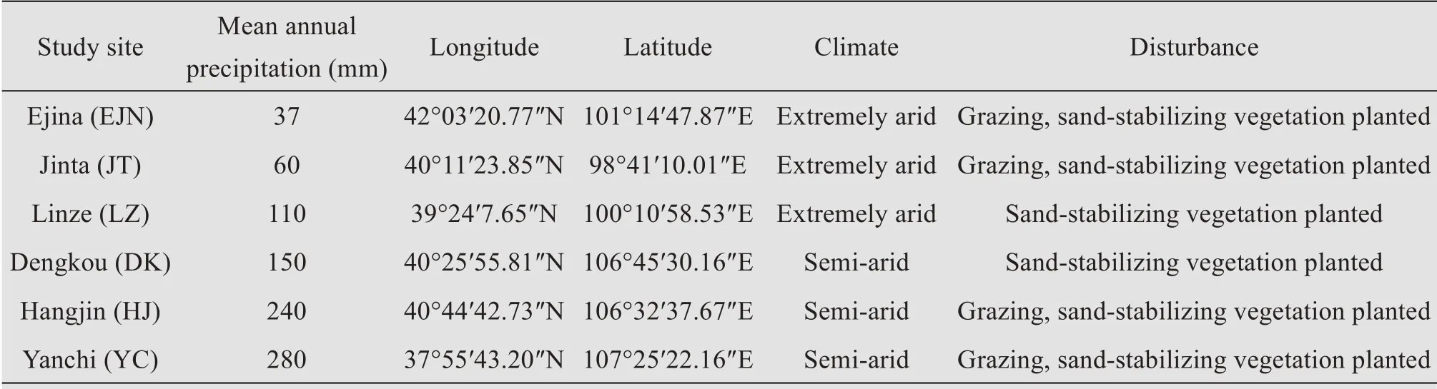
Table 1 Description of study sites
To determine nebkha morphological characteris‐tics,we measured height (H) at the highest point,length (L),and width (W) with a tape measure.Neb‐kha height (H) means the height of nebkha dunes.Nebkha area (A) was calculated for an elliptical shape as [π(L×W)/4].Volume (V) was calculated as a hemiellipsoid ([π(L×W×H)/6]) (Zhanget al.,2011).Shrub cover (C) was defined as the proportion of shrub above projected area to nebkha above superficial area,and visually estimated(Liuet al.,2015).
To determine soil nutrients,we sampled soil at 0 −10 and 10−20 cm depth in the center of nebkhas and in the inter-nebkha areas.Then,soil was analyzed for organic matter (SOM),total carbon (TC),total ni‐trogen (TN),and total phosphorus (TP).Soil nutrient samples were processed and analyzed in the Key Lab‐oratory of Ecohydrology of the Inland River Basin,Chinese Academy of Science.
To determine plant richness (R),we recorded spe‐cies abundance over the entire nebkha.For bunch grasses,we counted the number of clusters;for spe‐cies with discrete individuals,we counted the number of individuals(Liuet al.,2007).
3 Data analysis
Before analysis,all data were checked for homo‐geneity of variances.We used a one-way ANOVA to determine the effects of precipitation on morphologi‐cal characteristics,soil nutrient,and species richness.Mean annual precipitation (MAP) was treated as a fixed factor.Differences obtained at a level ofp<0.05 were considered significant.Significant differences in measured variables were assessed using Tukey's HSD test.Linear or quadratic regressions were used to de‐scribe the relationships between MAP and nebkha morphological characteristics (nebkha height,volume and coverage),soil nutrient (SOM,TC,TNandTP)and species richness.All statistical analyses were per‐formed with SPSS 18.0 software package (SPSS,Chi‐cago,IL,USA).
4 Results
4.1 Changes in morphological characteristics of nebkhas along a precipitation gradient
Morphological characteristics of nebkha changed significantly along a precipitation gradient (Tables 2,3).Nebkha height,area,and volume decreased with an increase in MAP (Figures 2a,2b).In contrast,shrub cover and the number of species increased sig‐nificantly with an increase in MAP (Figures 2c,2d).Relationships between all morphological characteris‐tics and MAP were linear.The largest and the small‐est nebkha heights were found in EJN and YC,where MAP was 37 and 280 mm,respectively(Table 2).
4.2 Changes in soil nutrient contents of nebkha along a precipitation gradient
Soil nutrient content in different soil layers dif‐fered between nebkha and inter-nebkha areas (Figures 3−6).MAP had a significant effect onSOM,TC,TNandTP(Table 4).SOMcontent within nebkha and in inter-nebkha areas increased linearly with an increase in MAP (Figure 3).SOMin the 0−10 cm layer was significantly higher within than in inter-nebkha areas except for DK (MAP of 150 mm) and YC (MAP of 280 mm) (Figure 3).In JT (MAP of 60 mm),LZ(MAP of 110 mm)and YC,SOMin the 10−20 cm lay‐er was significantly higher within than in inter-nebkha areas(Figure 3).
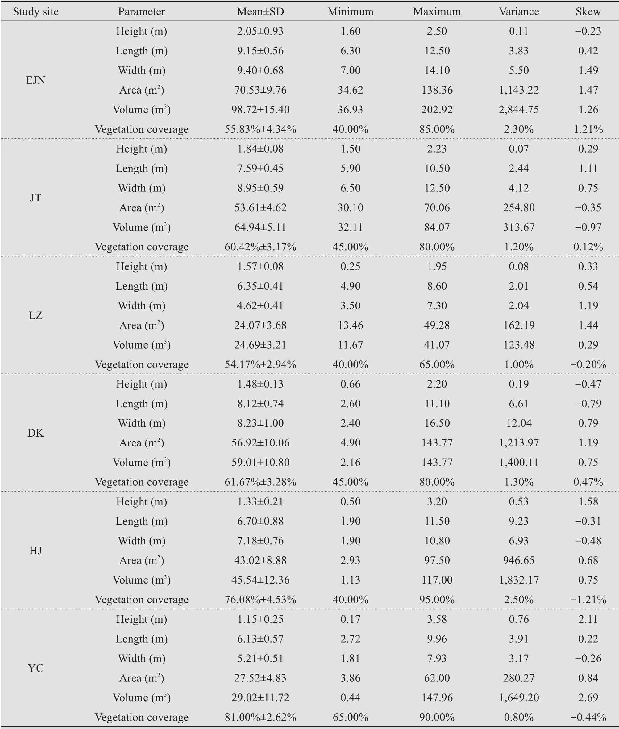
Table 2 Morphological parameters of nebkhas of different sites

Table 3 ANOVA analysis for effect of mean annual precipitation(MAP)on nebkha characteristics
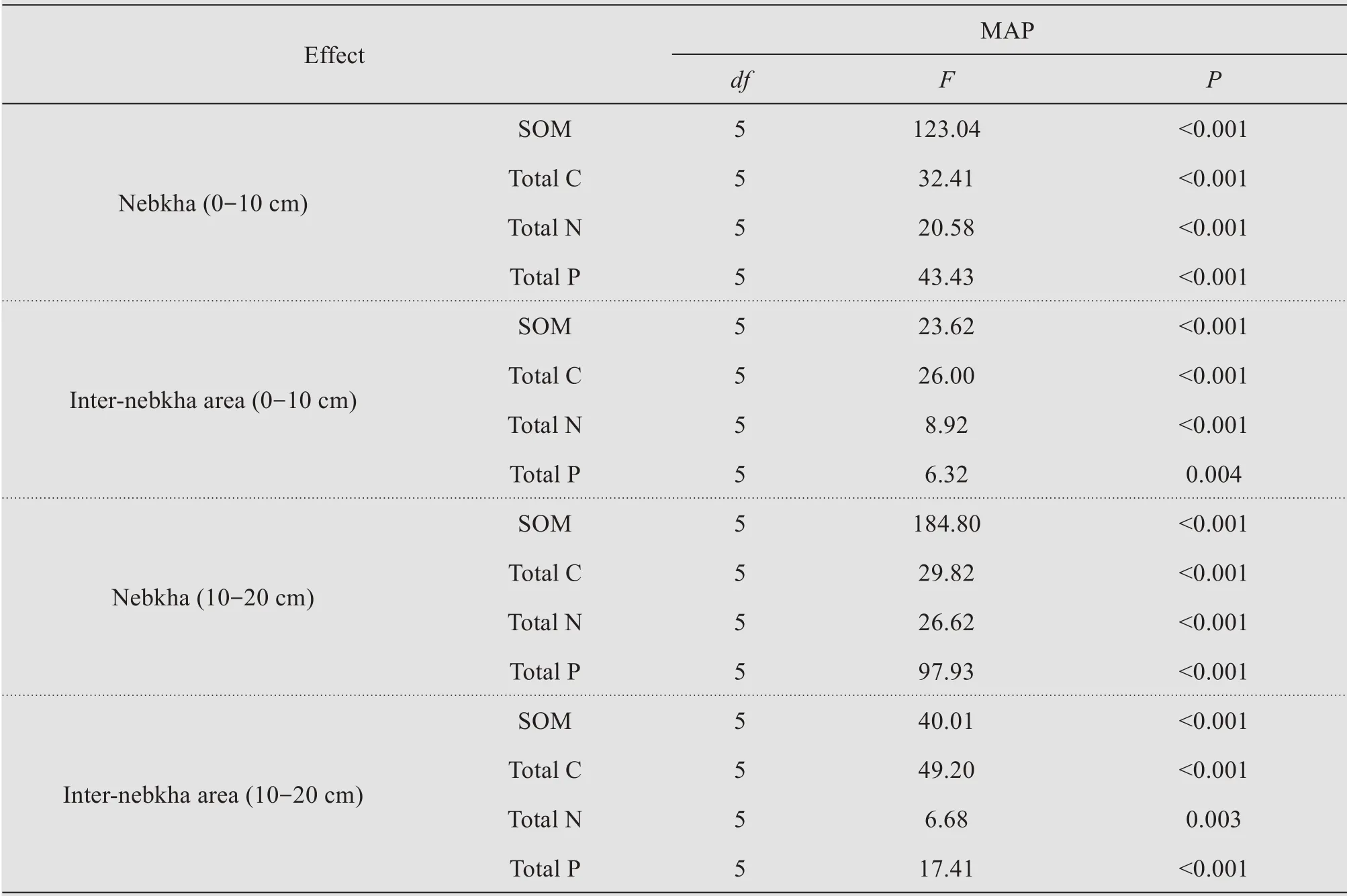
Table 4 ANOVA analysis for effect of mean annual precipitation(MAP)on soil nutrient content of nebkhas and inter-dune lands
The relationship betweenTCcontent in different soil layers of nebkhas or inter-nebkha areas and MAP can be described with linearly or polynomial functions,but not significant(Figure 4).TCcontent in the 0−10 cm layer within nebkhas was significantly higher than that in inter-nebkha areas in all plots (Figure 4) except HJ(MAP of 240 mm)and YC (MAP of 280 mm).In EJN(MAP of 37 mm) and JT,TCcontent in the 10−20 cm layer within nebkhas was higher than in inter-nebkha areas.However,in LZ,HJ,and DK,TCcontent in the 10−20 cm layer within nebkhas was significantly low‐er than in inter-nebkha areas(Figure 4).
TNwithin nebkhas and in inter-nebkha areas in‐creased linearly with an increase in MAP (Figure 5).In HJ and DK,TNcontent at the 0 to 10 cm layer of nebkhas was significantly lower than in inter-nebkha areas (Figure 5).In EJN,JT,and YC,TNat the 10 to 20 cm layer within nebkhas was significantly higher than in inter-nebkha areas.However,the trends were opposite in LZ,HJ,and YC(Figure 5).
TPcontent in nebkha and inter-nebkha areas in‐creased linearly with an increase in MAP (Figure 6).TPcontent in the 0−10 cm layer in EJN and LZ was significantly higher within nebkhas than in inter-neb‐kha areas,but the trends were opposite in JT and HJ(Figure 6).In EJN and JT,TPcontent in the 10 to 20 cm layer within nebkhas was significantly higher than inter-nebkha areas.However,in other sites,the trends were opposite(Figure 6).
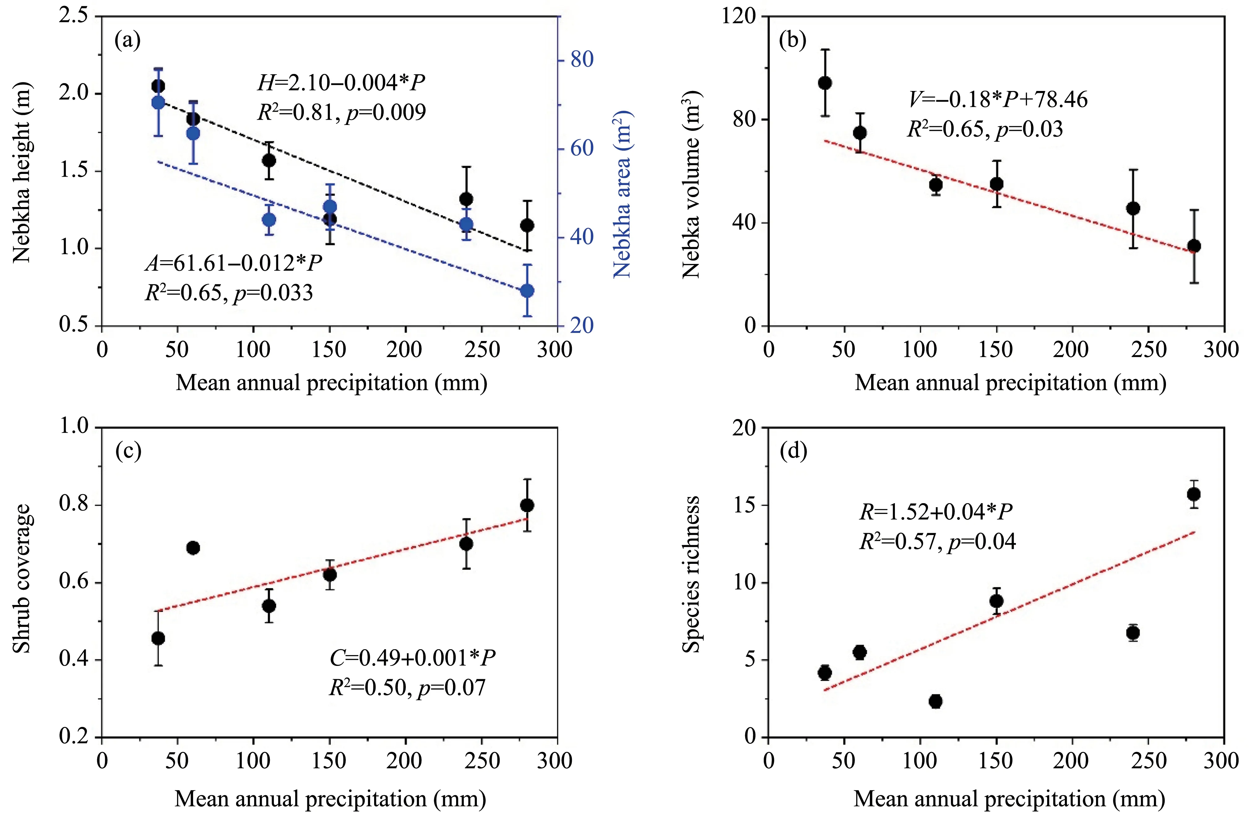
Figure 2 Changes in nebkha height and area along a mean annual precipitation gradient Values are means±standard error.Confidence interval is 95%
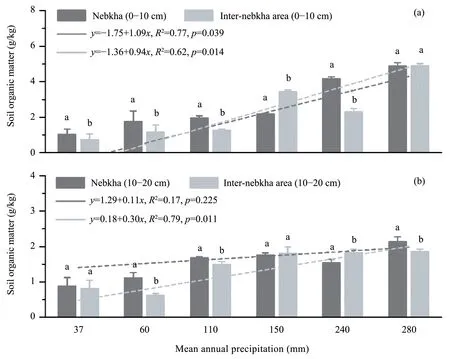
Figure 3 Soil organic matter in two soil layers within and in inter-nebkha areas along a precipitation gradient.Values are means±standard error.Different lowercases show significant difference between nebkha and inter-nebkha area
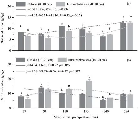
Figure 4 Soil total carbon in two soil layers within and in inter-nebkha areas along a precipitation gradient.Values are means±standard error
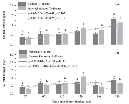
Figure 5 Soil total nitrogen within nebkha and in inter-nebkha areas for two soil layers along a precipitation gradient.Values are means±standard error
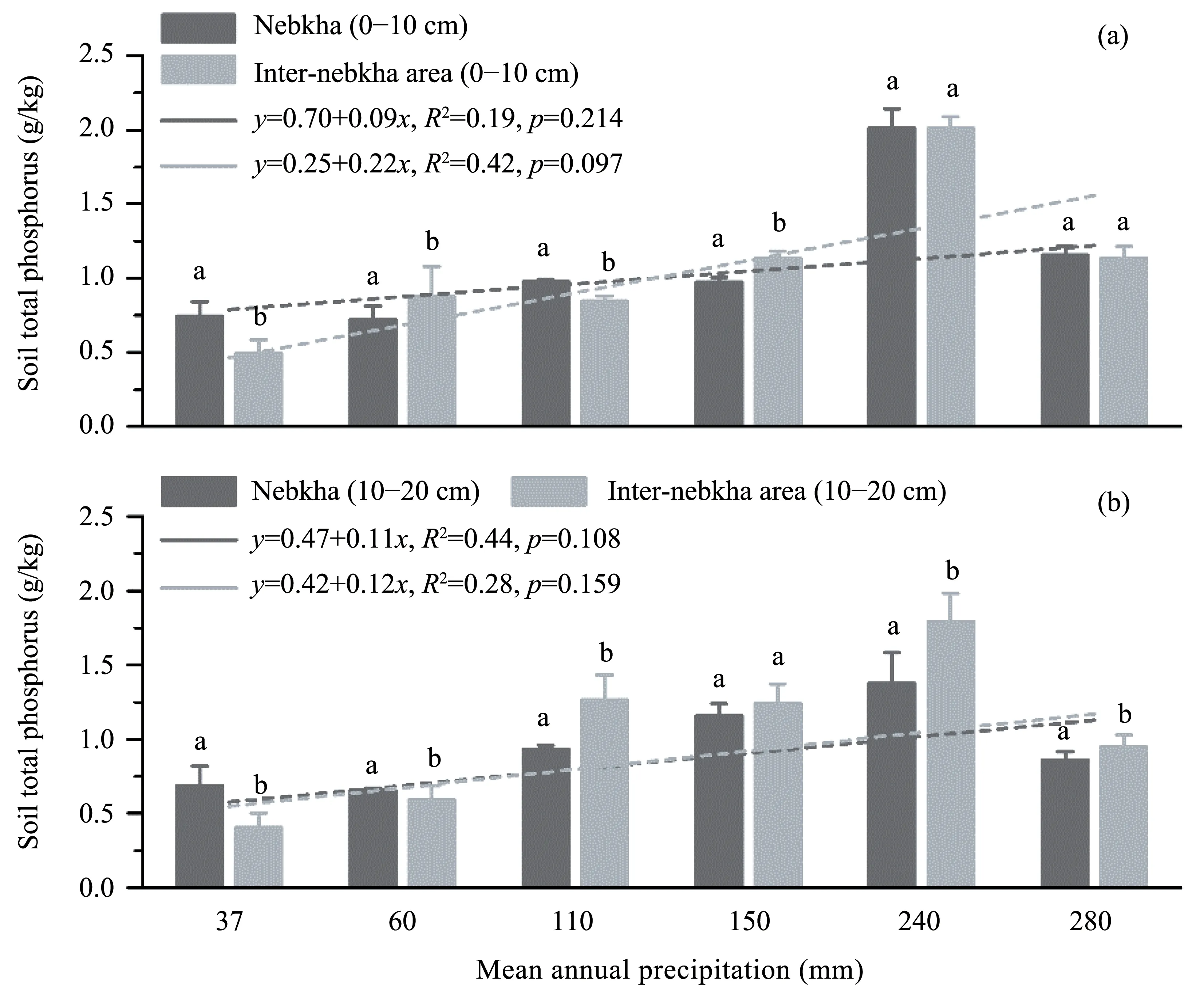
Figure 6 Soil total phosphorus within nebkha and in inter-nebkha areas for two soil layers along a precipitation gradient.Values are means±standard error
5 Discussions
5.1 Changes in morphological characteristics of nebkhas along a precipitation gradient
At large scales,climate change,anthropogenic ac‐tivity,and hydrogeological conditions have important effects on morphological characteristics of nebkhas(Wanget al.,2006;Cabrera-vegaet al.,2013).There‐fore,nebkhas in arid climates are typically larger than nebkhas in humid climates,and the volume of neb‐khas in extremely arid areas can be hundreds of times greater than that in semi-arid regions of China.At small scales,the most important factors which control morphological characteristics of nebkhas are growth characteristics of nebkha host plants,sand sources,and wind conditions (Khalaf and Al-Awadhi,2012;Hesp and Smyth,2019).For example,plants such asN.sphaerocarpa,which exhibit a prostrate growth habit,form small nebkhas,while plants such asT.ra‐mosissima,with vertical,dense,multi-branching growth habit,form large nebkhas (Hesp and McLach‐lan,2000;Luoet al.,2019).
Our results show that MAP had a significant ef‐fect on morphological characteristics of nebkhas (Ta‐ble 2).Nebkha morphological parameters such as height,area,and volume significantly decreased with an increase in MAP (Figure 2).On one hand,high precipitation promotes the growth of plants and increases vegetation cover in inter-nebkha areas,re‐sulting in a decrease in sand and wind speed (Quetset al.,2017).Thus,high precipitation inhibited the growth and development of nebkhas.In contrast,drought is one of the most important drivers of de‐sertification,with abundant sand sources and strong winds in regions with very low precipitation (Wanget al.,2008).Thus,nebkha host plants can intercept more sediments and form larger nebkhas,with low precipitation indirectly promoting accumulation pro‐cess.On the other hand,although limited precipita‐tion also inhibits nebkha host plant survival and growth,these plants have some unique strategies to withstand and adapt to extremely arid environments(Luo and Zhao,2019),and host plants in these re‐gions can form very large nebkhas.
In arid and semiarid regions,water availability in the soil is the most critical factor controlling produc‐tivity and reproduction of plants (Noy-Meir,1973;Rodriguez-Iturbe,2000).Soil moisture inside neb‐khas is the most important factor limiting the estab‐lishment of herbaceous plants on nebkhas (Zhanget al.,2011).Our results show that MAP had signifi‐cant positive effects on shrub cover and species rich‐ness of nebkhas,and nebkha host plant cover and species richness increased with an increase in MAP(Figure 2).Rainfall is the main water source for plant communities in arid regions (Zhouet al.,2016),and soil moisture in nebkhas was positively related to MAP.Thus,shrub cover and species rich‐ness of nebkhas in areas with high MAP were higher than those in areas with low MAP.
5.2 Changes in soil nutrient content of nebkha along a precipitation gradient
Nebkhas can be viewed as "fertile islands",be‐cause they can encourage aeolian sediment deposi‐tion,and retain water and nutrients (El-Banaet al.,2002;Fieldet al.,2012).Earlier studies indicated that soil water and soil organic matter,total nitrogen,phos‐phorus,potassium,and sodium contents in nebkhas were significantly higher than those in inter-nebkha areas(El-Banaet al.,2002;Zhanget al.,2011).Based on the high soil nutrient content and low photosynthet‐ically active radiation,species richness and plant den‐sity on nebkhas were significantly higher than in internebkha areas,and nebkhas can be considered as "veg‐etation islands" (El-Banaet al.,2002;Luoet al.,2016).Similarly,our results show that soil contents ofSOM,TN,TP,andTCin nebkhas were higher than in inter-nebkha areas(Figures 3−6).
There are two main reasons for the higher soil nu‐trient content inN.sphaerocarpanebkhas than in in‐ter-nebkha areas.First,as hemispheroid forms,N.sphaerocarpacanopies can trap more sand and accu‐mulate more soil nutrients.Second,buried branches and litter ofN.sphaerocarpaare decomposed by mi‐crobes,and increase soil nutrient contents in nebkhas.This contributes to the role ofN.sphaerocarpaneb‐khas in these areas as "fertile islands" and to their im‐pact on ecosystem dynamics in these regions.
However,the "fertile island" effect of nebkhas may not be a simple result of litter and nutrient accu‐mulation (Zhanget al.,2011) because soil in neb‐khas is substantially modified as a result of interac‐tions between soil microbial processes,soil water,lit‐ter,nutrients,and soil structure (Hesp and McLach‐lan,2000;Zhanget al.,2011).Soil water is a key factor which determines these interactions especially in water limited systems (Bhark and Small,2003).Our results also show that soil nutrient content of nebkhas changed along a precipitation gradient.Soil nutrients in the 0 −10 cm soil increased with an in‐crease in MAP (Figures 3 −6).The main reason for this increase is probably the quality and decomposi‐tion rate of litter,which are higher in wet than in dry environments when other factors such as soil temper‐ature are constant (Riuttaet al.,2012;Leeet al.,2014;Petragliaet al.,2018).Decomposition rate of buried branches and litter in nebkhas in higher MAP regions was higher than in nebkhas in lower MAP ar‐eas.Thus,soil nutrients content of nebkhas were sig‐nificantly positively related to MAP.
Site HJ differed from other sites in that soilSOM,TN,andTPof nebkhas were lower than in inter-neb‐kha areas (Figures 3−6).We attributed this difference to the relationships among the quality of soil litter,soil resources,the size of plant canopies,and nebkha developmental stages,as the strength of the fertile is‐land effect increases with the development of nebkhas(Zhanget al.,2011).Further,litter and nutrients start accumulating in quantities sufficient to form a fertile island only during later developmental stages of indi‐vidual plants (Schlesingeret al.,1996;Liet al.,2008).As a result,fertile islands do not form at the early development stage of nebkhas at HJ.
5.3 Effects of human activities on nebkha development
Sand resource is another key factor which con‐trolled the survival and development of nebkhas (Hesp and McLachlan,2000).Large and dome-shaped neb‐khas develop in sand-abundant regions,while small and elongated nebkhas are found in sand-deficient areas (Khalafet al.,2014).On one hand,degradation of non-protected nebkhas is attributed to drastic reduc‐tions in nebkha shrub canopies which increase suscep‐tibility of nebkha sediments to wind erosion;anthro‐pogenic activities,in particular,overgrazing by farm animals is responsible for such degradation (Khalafet al.,2014).On the other hand,some human activities,such as establishment of sand-stabilizing vegetation and engineering measures significantly limited sedi‐ment deposition at nebkhas and the growth of nebkha host plants (Luo and Zhao,2019).The main reason was sand burial facilitated the growth and clonal re‐production of nebkhas host plants (Quet al.,2014;Luo and Zhao,2019).
During field investigation,we found that some nebkhas in LZ were degraded (Luo,personal observa‐tion).The main reason was that non-native sand-stabi‐lizing vegetation such asHaloxylon ammodendronwas established beside nebkha landscape,significant‐ly limiting sediment deposition at nebkhas.Thus,the development of nebkhas in this area was inhibited.Due to the important roles of nebkhas in sand inter‐ception and biodiversity protection in arid and semiarid regions,some necessary protective measures must be considerate to protect nebkha landscapes.1)Eestablishment of a nature reserve to protect nebkhas which were serious degraded.2) Some human activi‐ties such as grazing must be limited.3) Control areas of artificial sand-stabilizing vegetation.
6 Conclusions
Our study shows that morphological characteris‐tics and soil nutrient patterns of nebkhas were signifi‐cantly different along a precipitation gradient.Mean annual precipitation (MAP) had significant effects on morphological characteristics of nebkhas,and height,area,and volume of nebkha significantly de‐creased with an increase in MAP.Further,MAP had significantly positive effects on shrub cover and spe‐cies richness of nebkha.This indicates that high pre‐cipitation inhibited growth and development of neb‐khas because high precipitation increased species richness and vegetation cover of inter-nebkha areas,and decreased sand and wind speed.In contrast,vast nebkhas developed in areas with low precipitation.Soil nutrients such asSOM,TC,TN,andTPin the 0−10 cm layer increased with an increase in MAP,in‐dicating that decomposition rate of buried branches and litter in nebkhas in higher MAP areas was higher than in nebkhas in low MAP areas.SoilSOM,TN,TP,andTCwithin nebkhas were higher than in internebkha areas,indicating thatN.sphaerocarpaneb‐khas in these areas function as "fertile islands" and play an important role in ecosystem dynamics of these regions.We conclude that MAP is a key factor which determined zonal differences,and morphologi‐cal and soil nutrient patterns of nebkhas.However,human disturbance such as grazing and the establish‐ment of sand-stabilizing vegetation significantly limited sediment deposition and the development of nebkhas.Protection of nebkha landscapes needs to include nebkha vegetation,and limit human use of nebkha areas.
Acknowledgments:
We would like to thank Dr.Kathryn B.Piatek (kbpi‐atek@gmail.com) for her assistance with English lan‐guage editing and valuable comments on this article.We gratefully acknowledge the journal's anonymous reviewers for their valuable comments on our manu‐script.This study was supported by the National Ba‐sic resource survey (2017FY100200),Natural Science Foundation of China subsidization project (41471435)and the West Light Program for Talent Cultivation of the Chinese Academy of Sciences.
 Sciences in Cold and Arid Regions2021年3期
- Sciences in Cold and Arid Regions的其它文章
- A concise overview on historical black carbon in ice cores and remote lake sediments in the northern hemisphere
- Summary of research on frost heave for subgrade in seasonal frozen ground
- Overview of an early warning system for Glacial Lake outburst flood risk mitigation in Dudh-Koshi Basin,Nepal
- Temporal changes in seasonal precipitation over the Sahara Desert from 1979 to 2016
- Centrifuge model test on performance of thermosyphon cooled sandbags stabilizing warm oil pipeline buried in permafrost
- Linkages between soil microbial stability and carbon storage in the active layer under permafrost degradation