
Overview of an early warning system for Glacial Lake outburst flood risk mitigation in Dudh-Koshi Basin,Nepal
2021-07-30 01:11SanjayaGurungSarojDhojJoshiBinodParajuli
Sanjaya Gurung ,Saroj Dhoj Joshi ,Binod Parajuli
1.Real Time Solutions Pvt.Ltd.,Lalitpur 44700,Nepal
2.Department of Hydrology and Meteorology,Kathmandu 44600,Nepal
ABSTRACT Natural disasters inflict severe damage on almost the entire spectrum of social and natural habitats.This ranges from hous‐ing and shelter,water,food,health,sanitation to information and communication networks,supply of power and energy,transportation infrastructure,and others.Nepal is a risk prone country for Glacial Lake Outburst Flood (GLOF).GLOFs exist as major challenges as they repeatedly cause a heavy toll of life and property.During such a disaster,major challeng‐es are indeed the protection of life,property and vital life-supporting infrastructure.Any delay or laxity in disaster relief can escalate the magnitude of distress for the victims.Thus,rather than trying to take curative measures,it is better to min‐imize the impacts of GLOF.These measures subsequently help in reducing the magnitude of death and casualties due to a GLOF event.This reduction of impact is often achieved by optimizing preventive measures.For applying necessary deter‐rent measures,it is essential to disseminate information about the danger beforehand.Early Warning System(EWS)is an im‐portant step for such information dissemination for GLOF disaster management and helps to anticipate the risk of disaster and disseminate information to lives at risk.It is impossible and impractical to reduce all GLOF risks,but it is possible to re‐duce several impacts of a GLOF through the implementation of the EWS.This paper presents the design and implementation of an EWS for monitoring potential outbursts of a glacier lake in the Dudh-Koshi Basin,Nepal.
Keywords:glacier;climate change;early warning system;glacial lake outburst flood
1 Introduction
The impact of climate change on Himalayan gla‐ciers has increasingly become the subject of public and scientific debate (e.g.,Bolchet al.,2012).Climate change has been contributing to glacial retreat and expansion of lakes,thereby increasing GLOF risks.Previous studies by Kulkarni (1992),Cogleyet al.(2010),Bolchet al.(2012),Wagnonet al.(2013),Zhanget al.(2015) and Gurunget al.(2016) also show that Himalayan glaciers are experiencing a higher retreat rate in recent decades.Nepal has wit‐nessed 24 GLOF events to date (Mool,1995;Yama‐da,1998a;Moolet al.,2001a;Bajracharyaet al.,2007;Bajracharyaet al.,2008;Iveset al.,2010;ICI‐MOD,2011).Glacial lakes in Nepal face a huge risk of outburst due to the ongoing effects of climate change.Warming climate in the region is leading to a considerable amount of snow and glacier melt thus weakening the natural barriers holding these high alti‐tude glacial lakes.Therefore,Nepal is at an ever grow‐ing risk every year and always waiting for an inevita‐ble natural disaster.
Out of 1,466 glacial lakes in Nepal,21 have been identified as potentially dangerous glacial lakes,of which six have been placed in the high-risk category,such as Imja Glacial Lake in Solukhumbu District.(ICIMOD,2011).A study undertaken by UNDP in 2014 revealed that Imja Glacial Lake covers an area of 1.28 km2,and has a depth of 148.9 meters.The lake is holding a large volume (about 75.2 million cubic meters) of water thereby posing a serious threat for the occurrence of a GLOF event.This event could result into significant loss of lives and properties as there are human settlements down‐stream.Since May 2016,an Early Warning System was implemented at Imja Glacial Lake through the Community Based Flood and Glacial Lake Outburst Risk Reduction Project (CFGORRP).Since GLOFs can cause extremely huge loss of human lives and physical properties,it is very important to implement a mechanism which helps reduce the hazards from such events.
The GLOF Early Warning System has been devel‐oped and installed at Imja Glacial Lake to help reduce economic losses and mitigate the number of injuries/deaths by providing pre-information that allows com‐munities downstream of lake to protect their lives and properties.
The main objective of the system is to ensure timely dissemination of the early warning to vulnera‐ble or disaster prone areas significantly reducing the hazards and destruction arising from probable GLOF events through Imja Glacial Lake in Dudh-Koshi Ba‐sin.This helps in decision making to set out a strategic context for managing GLOF risk and to implement a well-prepared emergency response to help people in danger and protect as many properties as possible.
2 Project area
The project site for the Early Warning System is at Imja Glacial Lake (28.8°N and 83.4°E),located in the Dudh-Koshi Basin,Solukhumbu District of eastern Ne‐pal,within Sagarmath National Park(Figure 1a).
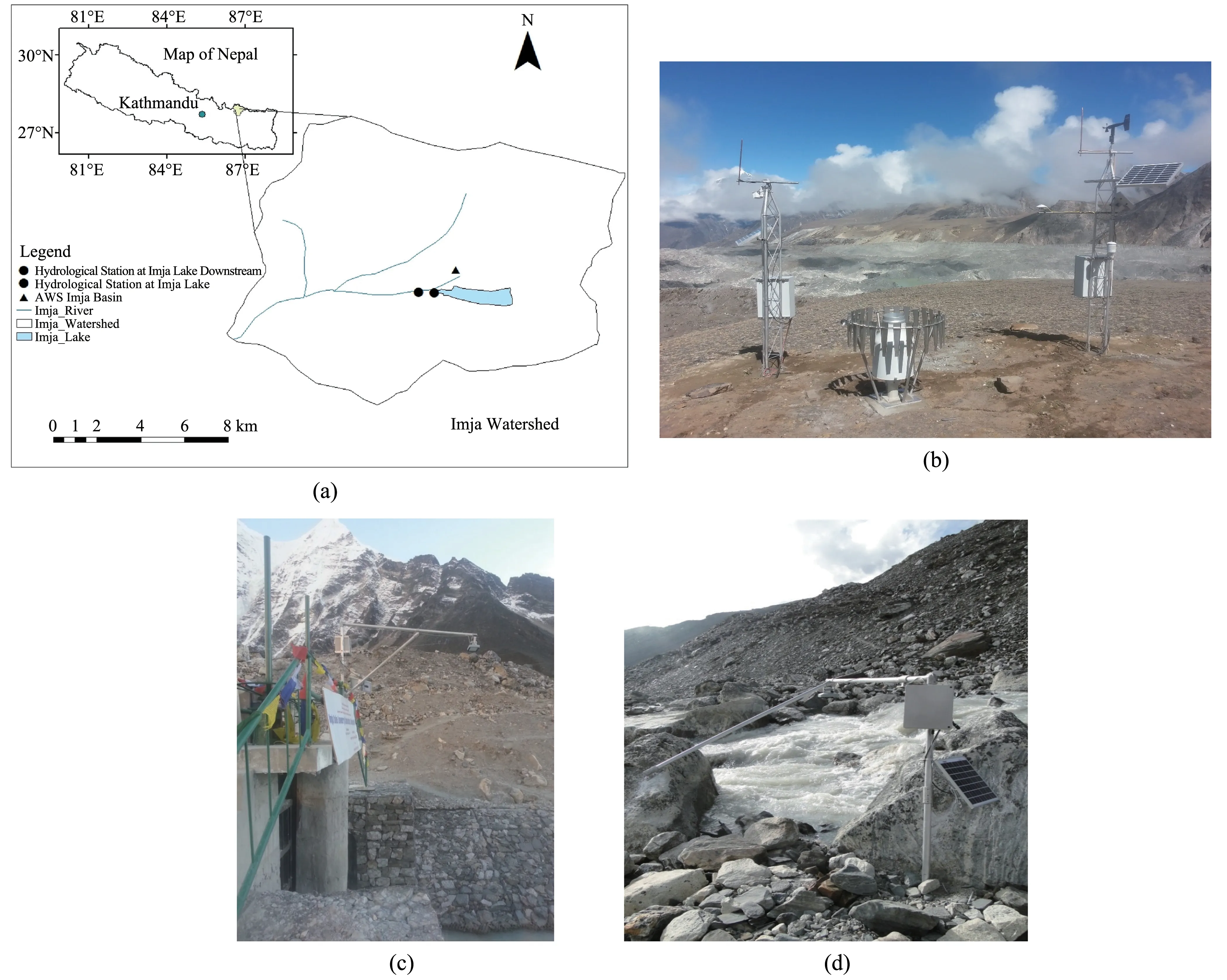
Figure 1 Image of Imja Lake and the location of Hydrological and Meteorological Stations at Imja in the Dudh-Koshi Basin(a).Automatic Weather Station near Imja Glacial Lake(b).Automatic Hydrological Station at Imja Glacial Lake(c).Automatic Hydrological Station at Imja Glacial Lake Downstream(d)
One automatic meteorological station was in‐stalled near Imja Glacial Lake on May 27,2016(5,172 m a.s.l.)and two hydrological stations were in‐stalled,one at the outlet of Imja Glacial Lake on June 2,2016(5,013 m a.s.l.)(Figure 1)and the other down‐stream of Imja river on June 5,2016 (4,951 m a.s.l.).Ten GLOF detection sensors (Figure 2) were also in‐stalled in the periphery of Imja Glacial Lake,includ‐ing automatic early warning sirens in six prime settle‐ments of Dingboche,Pangboche,Fungithanka,Jorsal‐le,Phakding,and Ghat,installed and operationalized during 2016 in the Imja Dodh-Koshi River Corridor.Hydrological stations at Imja Glacial Lake and at Im‐ja Glacial Lake Downstream are located at 86.91°E longitude and 27.90°N latitude and 86.90°E longitude and 27.89° N latitude,respectively.An Automatic Weather Station is located at 86.92°E longitude and 27.90°N latitude in the Dudh-Koshi River Basin.
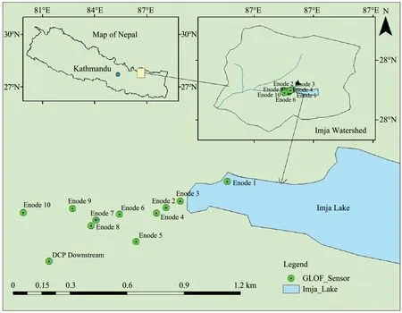
Figure 2 Location map of GLOF Detection Sensors at outlet and downstream of the Imja River
3 Materials and methods
3.1 System overview
The Imja Glacier Lake Early Warning System com‐prise of GLOF sensing stations and warning stations(Figure 3).The GLOF sensing stations −at upstream and downstream,consists of a network of different sen‐sors to detect occurrence of any probable GLOF event.Data and information from automatic weather stations and GLOF sensing stations are transmitted to the cen‐tral server through different communication channels−mobile technologies (Code-division multiple access(CDMA)/Global System for Mobile Communications(GSM)),satellite communication and local wireless network.During any GLOF event,data from all field stations are monitored and analyzed and then warn‐ings are disseminated to downstream communities through warning stations.Similar technology was im‐plemented in the Tsho-Rolpa Glacial Lake for GLOF Early Warning System (CEPTE/KU,2012;HiCCDRC,2012;Maskeyet al.,2013;Shresthaet al.,2014).
3.1.1 Wireless Remote Terminal Unit
The wireless terminal unit (Figure 4) uses a wire‐less network to connect the sensors.To power the Wireless Remote Terminal Unit (WRTU),it has its own small unit of battery,solar and charge controller.Further,each WRTU has its own in-built movement sensor.
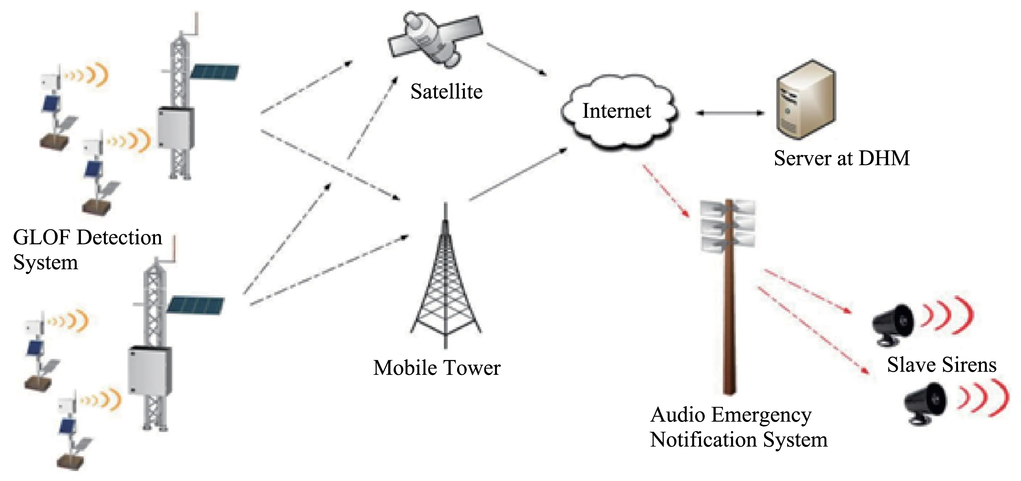
Figure 3 Overview of GLOF Early Warning System
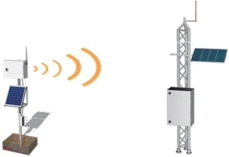
Figure 4 Image of Wireless Remote Terminal Unit
3.1.2 Automatic Weather Station and GLOF Detection System at lake area
The purpose of GLOF Detection Sensors and Au‐tomatic Meteorological Station are to provide early warning of occurrence of any probable GLOF event.The meteorological requirements for sensors used at automatic weather stations(AWSs)are not very differ‐ent from those of sensors at manual observation sta‐tions(WMO 1992;2013;2015).The automatic weath‐er station measures the following parameters:
i)Water Level;
ii)Wind Speed and Direction;
iii)Air Temperature;
iv)Relative Humidity;
v)Atmospheric Pressure;
vi)Solar Radiation;
vii)Snow Depth;
viii)Precipitation.
Values of these parameters are logged as per World Meteorological Organization standard (WMO,1987;2008;2010;2011;2014) and then transmitted to the central server through different satellite commu‐nication channels.
3.1.3 Sensors
i)Water level sensor
Radar Level Sensor (RLS) (Figure 5) is a contact‐less water level measuring sensor;contactless because it is installed outside the water.The sensor sends short radar pulses to the water surface and waits for their re‐flection.The runtime of the pulses (time taken from transmission to reception) is used to calculate the dis‐tance between the water surface and the sensor.
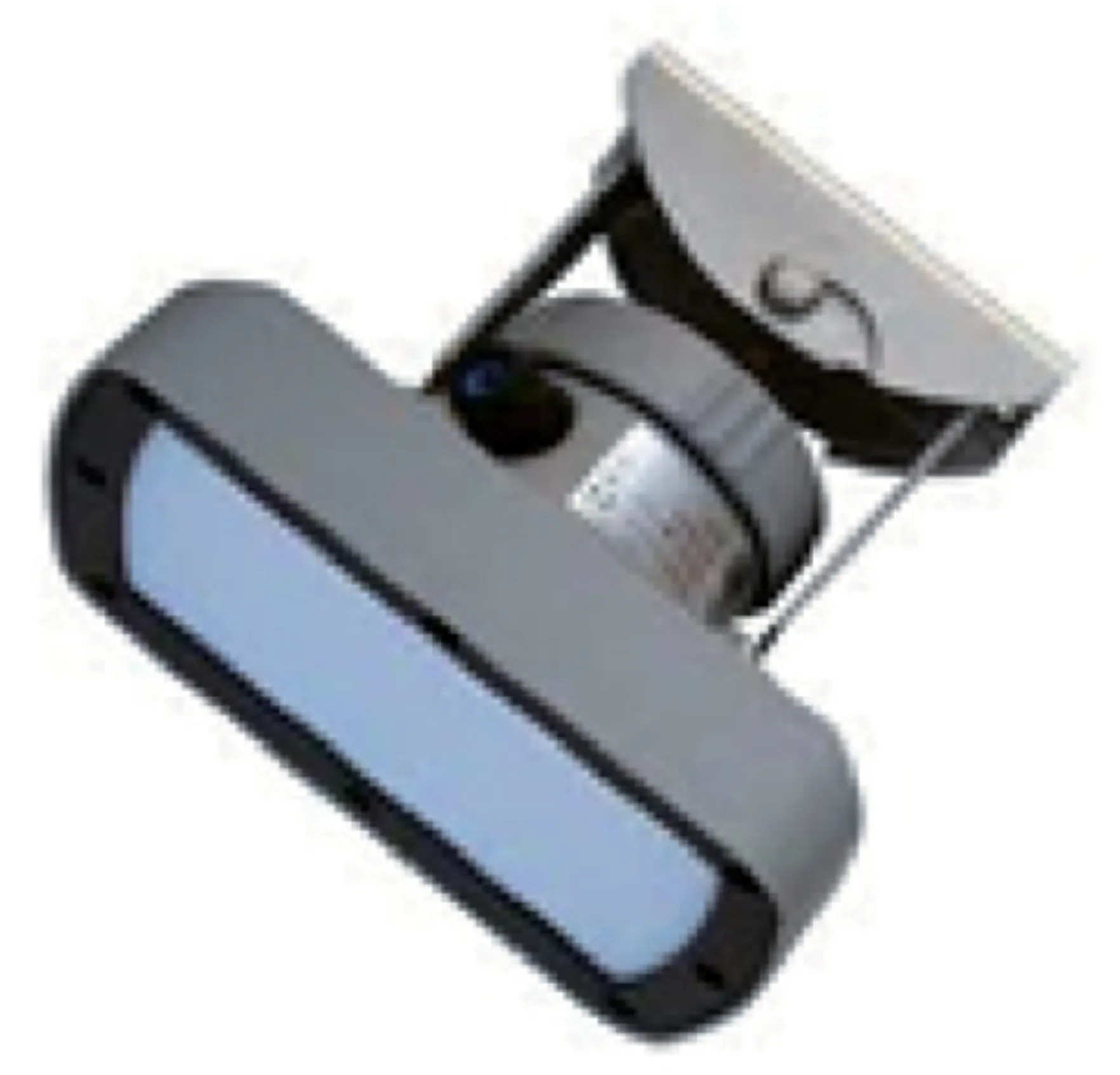
Figure 5 Radar Level Sensor(RLS)
The radar level sensors are installed high above the flood level by the construction of a physical struc‐ture.Further,the sensor is connected to wireless RTU to establish a wireless communication between the sensor and the Data collection platform (DCP).Two radar level sensors are installed,one at the outlet of Imja Glacial Lake and the other downstream of Imja river for water level measurements.
ii)Meteorological sensors
One Automatic Weather Station (Figure 6) was installed near the left lateral moraine of Imja Glacial Lake.The meteorological sensors include pluviome‐ter (OTT Pluvio),pyranometer (CMP6),temperature and humidity sensor (HC2A-S3),wind sensor(05103-45 Wind Monitor Alpine),snow-depth sensor(USH-9)and atmospheric pressure(PTB210)
The sensors use measurement technology of a wind propeller,Negative Temperature Coefficient(NTC) in temperature,relative humidity capacitance,pressure capacitance,radiation thermopile,weightbased technology to measure precipitation and ultra‐sonic snow depth sensor.
3.1.4 GLOF Sensing Stations
GLOF sensing stations detect occurrence of any GLOF event.The GLOF sensing station integrates a network of sensors to monitor different phenome‐non that indicates such event.Sensors are connect‐ed wireless to the DCP through WRTUM units,so as to prevent DCP from being washed away during GLOF event.Warning is triggered only if every sen‐sor indicates occurrence of GLOF.Here again,data are transmitted through different communication channels.
3.1.5 Data logger
The sensors are connected to a data logger,RTDL-11(Figure 8)that logs parametric values at defined in‐stances of time.The logging intervals for different pa‐rameters are user-definable.The data logger has two levels of storage.a) A temporary storage unit which stores values at the time of measurement;b)A perma‐nent storage unit;e.g.,a Micro SD Card which can store values for at least 10 years.Further,RTDL-11 can be completely maintained through the web;any change made in the web interfaces synchronized by RTDL-11,which makes it perfect for remote and unat‐tended areas.
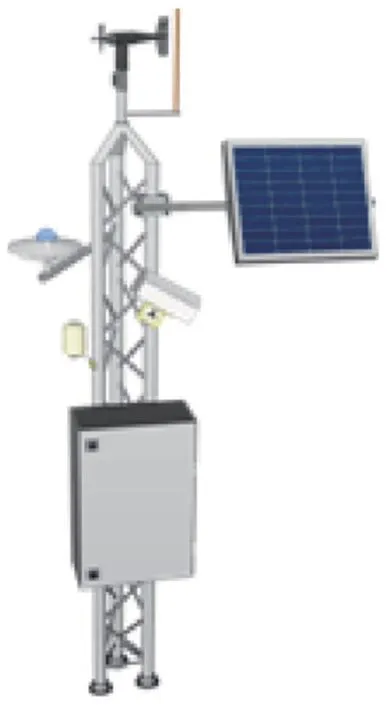
Figure 6 Automatic Weather Stations
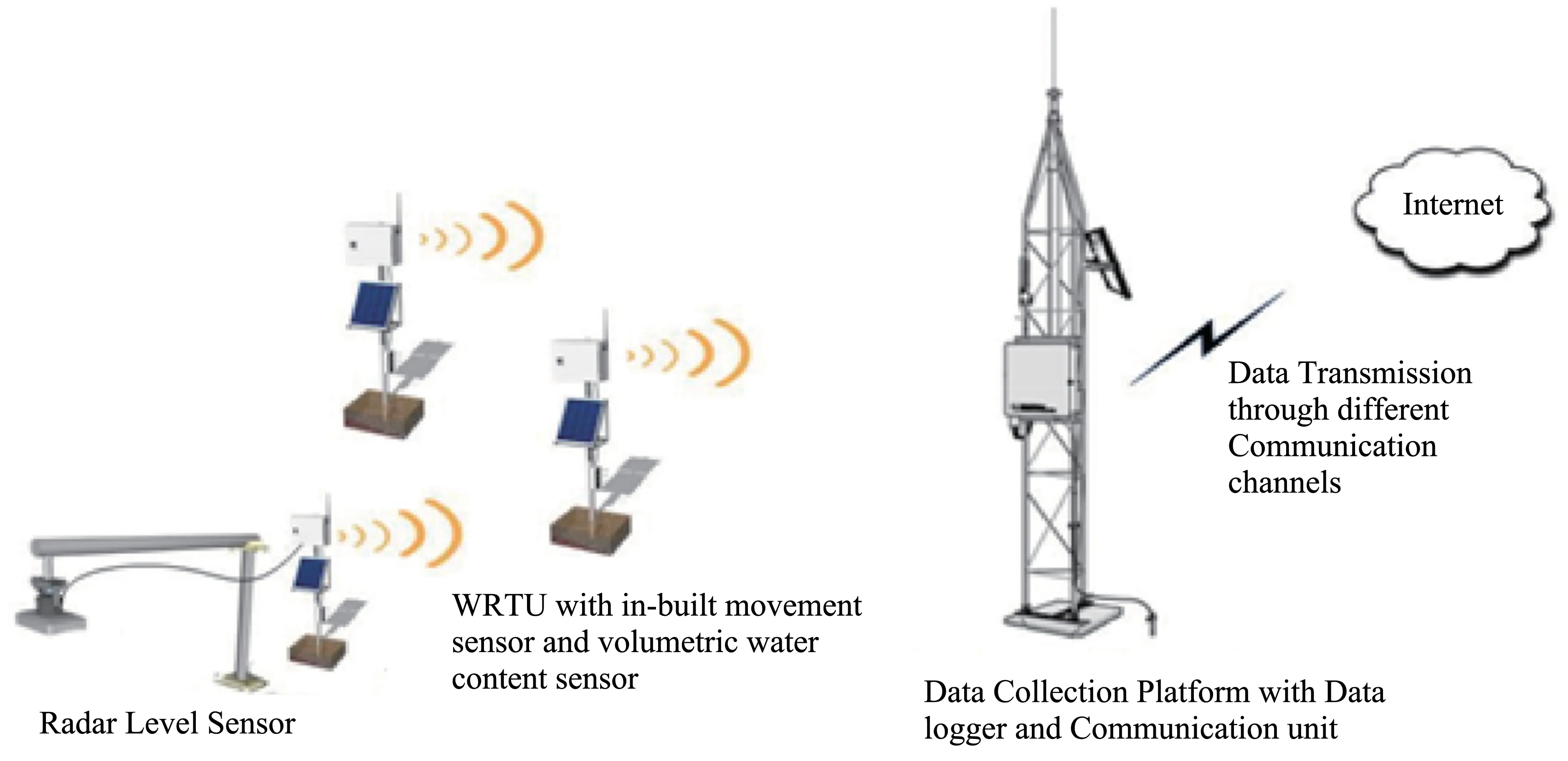
Figure 7 Overview of GLOF Sensing Stations
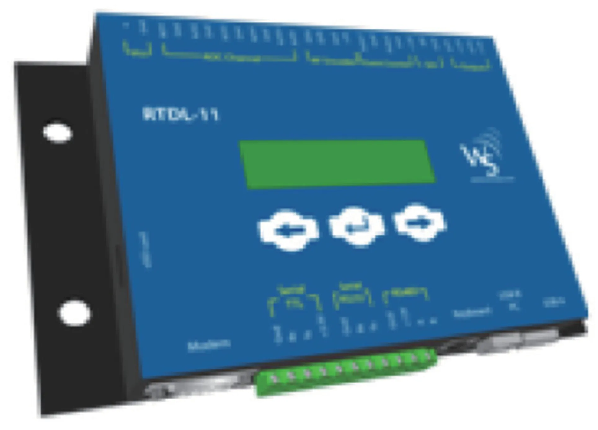
Figure 8 RTDL-11 data logger
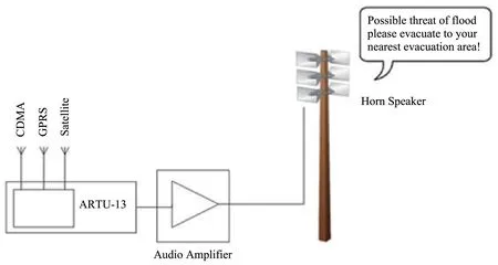
Figure 9 Schematic diagrams of Omni directional horn speakers
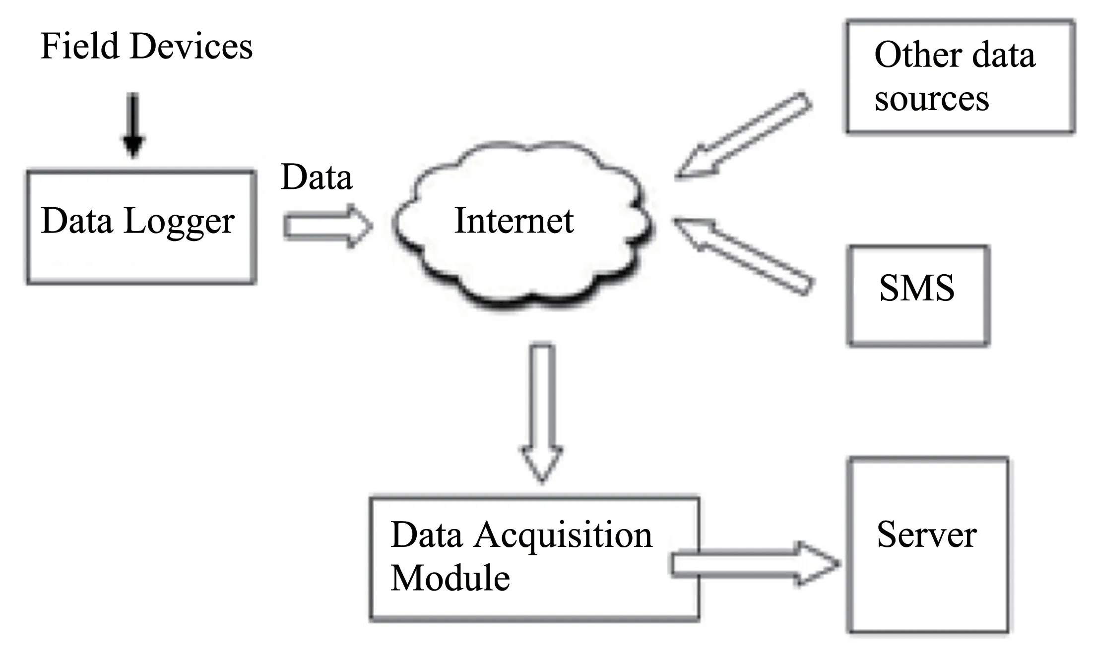
Figure 10 Overview of Data Acquisition Module
RTDL-11 also logs battery voltage so that battery health can be monitored.Also,it logs communication errors,signal strength whereby the user is informed about the communication status.
Data from the data logger can be downloaded direct‐ly into a pen drive where files are saved in csv format.
3.1.6 Communication module
The communication modem uses three different technologies−mobile technology and satellite commu‐nication to transmit data stored in the data logger to the central server.Using satellite,CDMA and General Packet Radio Services (GPRS) mobile technologies wherever available,the communication module trans‐mits real time data from different measurement sta‐tions to the server.For Imja GLOF EWS satellite com‐munication is used.
Considerable progress has been made in develop‐ing the knowledge and technical tools required to as‐sess risks and to generate and communicate predic‐tions and warnings,particularly as a result of grow‐ing scientific understanding and the use of modern information and communication technologies (UN,2006).
The communication modem uses smart technolo‐gy where it enables only the communication channel that is being used and deactivates any other communi‐cation channels.The purpose of deactivating other communication media while a particular channel is ac‐tive is to lower the power consumption.These sites are located at remote places and the only source to charge these systems is solar power.Thus,to elimi‐nate wastage of power,those communication chan‐nels which are currently not in use are kept idle.The communication module automatically switches be‐tween different communication media activating and deactivating as per required
3.1.7 Power system
To power all the system components,various sets of solar panels and batteries are used with different ratings as per required.The battery in the system is recharged by state of the art charge controller device.
Two 55−W solar panels are used instead of a sin‐gle large solar panel.Large solar panels can cause wind friction,hence two separate solar panels help in minimizing damage due to wind.
For power backup,sealed maintenance free VR‐LA batteries are used which can withstand extreme temperatures and they do not require periodic maintenance.
3.1.8 Audio Emergency Notification System
The Audio Emergency Notification System dis‐seminates information received from stations to warn communities of possible hazard from Imja GLOF.The Audio Emergency Notification System consists of following sub units:
i)Audio Remote Terminal Unit
The Audio Remote Terminal Unit is a digital de‐vice that has pre-recorded voice messages to dissem‐inate warning and information.It has built-in mo‐dems for internet connectivity that uses mobile tech‐nology and satellite communication.Thus,upon re‐ceipt of warning from GLOF sensing stations and verification of the event,the pre-recorded voice will be triggered through these various communication channels.
The pre-recorded voice messages can be upload‐ed to the web,and then downloaded to the audio ter‐minal unit as the scope of the notification system ex‐pands.This can be achieved remotely through the web from a central office eliminating the need of visiting the site itself.Thus,the audio emergency system can be used for multi-hazard purpose extend‐ing beyond GLOF only,e.g.landslide,fire,flash floods.
The audio remote terminal unit also supports Ses‐sion Initiation Protocol (SIP) to make live public an‐nouncements.The software used for Audio Remote Terminal Unit is common alerting protocol (CAP)compliant(WMO,2017).
ii)High efficiency audio amplifier
The high efficiency audio amplifier amplifies the low power audio signal triggered from the Audio Re‐mote Terminal Unit to a level suitable for driving the horn speakers for information dissemination.
iii)Horn speaker
Omni directional horn speakers are used to dis‐seminate warning of GLOF to the communities.Each warning station consists of two such horn speakers facing opposite directions.For locations where single siren system is not enough,an array of speaker were used to increase the voice message range.
GLOF is not a frequent event,including operation of the audio emergency notification system.Thus,to verify the system is working properly and ensure that it will work during flood events,current flow output of the amplifier is constantly checked.
3.2 Customized software for GLOF Early Warning System
Data from sensors are transmitted via communica‐tion module to a web server.Data and other valuable information are maintained for real time viewing and later archived or downloaded.To cater to the require‐ments of Imja GLOF Early Warning System,custom‐ized software is developed.
The GLOF Early Warning System software has the following modules.
3.2.1 Data Acquisition Module
Data Acquisition Module is a gateway for transfer‐ring data received from field devices into the database through the internet via Hypertext Transfer Protocol(HTTP).The field devices (DCP) are identified through unique device codes and security codes.The Data Acquisition Module is highly scalable with a number of interfaces to receive data via not just field devices but also SMS,online web pages.
3.2.2 Data Processing Module
The Data Processing Module process the data re‐ceived from field devices for their integrity.The data are also processed to derive secondary parameters from the raw data received from field devices.
The Data Processing Module have two main sub modules.
i)Automatic data quality control
The system consists of an automatic data quality control module that checks the received raw observa‐tion for the stations,checks for any inconsistencies or errors and flag or processes them.A number of rules are defined for automatic data quality control.The rules are executable in an order defined by the user.If the observation fails to comply for any one of the rules,the data are flagged and the user is informed via SMS or Email or Web based interface.The flagged da‐ta are not used for further processing until checked by a data specialist.The data quality control should be able to perform following checks automatically.
Limit check
The system automatically checks if certain obser‐vations have crossed certain thresholds or not.
Step check
The system checks if two consecutive observa‐tions fall within a certain limit or not.
Constant check
The system checks if a part of a time series obser‐vation does not change significantly.
Geographical check
The system compares an observation with another observation from some other station for geographical consistency.
Historical check
The system is able to compare an observation with a relatively older observation for historical consistency.
ii)Automatic data aggregation
The system automatically generates derived pa‐rameters based on primary parameters being received from remote stations.The aggregation rules are de‐fined in the following ways for derived parameters:
Time based aggregation
Derived parameters are generated from a primary parameter when aggregated over a certain period of time using functions like MIN,MAX,AVERAGE and SUM.
Algebraic equation
Derived parameters are generated using mathemat‐ical equations on one or more parameters.Ex:Calcu‐late discharge from stage height.
Tabular interpolation
Derived parameters are generated using an inter‐polation table.The interpolation table is defined with input and output values.The system automatically ag‐gregate a new parameter based on the tabular input us‐ing interpolation techniques.
3.2.3 Data Visualization Module
Data Visualization Module provides a large set of components for visualizing data in different standards and formats.
•Basic tabular view and graph view;
•Map view with Google map integration.
This module also provides highly customizable components for user specific needs and is scalable to add further visualization components.
Further,it provides public user data download in‐terface,where data can be downloaded in csv format for viewing in excel or other spreadsheet(Figure 12).
Figure 11 Map View with Google Map Integration
Figure 12 Graph View
3.2.4 Content/Document management
The Data Management Centre also provides an in‐terface to manage additional documents,reports,pub‐lications,and news related to stations and observa‐tions.This can be integrated with a data visualization component to create customizable web pages for dis‐play on public web sites.
3.2.5 Online (Web-based) system configuration interface
Any configuration in the system can be achieved through a web-based interface.This avoids the ne‐cessity of visiting installed stations to make any changes in the system,thereby allowing remote con‐figuration.
Credentials to access web-based information are provided only to concerned local and government au‐thorities.Moreover,a historical archive is maintained to log any changes made as per who made the chang‐es on which date and time.
3.2.6 Automatic and Human Assisted Decision Support System Module
This module automates the process flow for gener‐ating alerts when field devices sense abnormal condi‐tions in the environment.The general process is illus‐trated by the following flowchart(Figure 13):
The countdown timer is set in a lower time peri‐od for upstream villages and a longer period for downstream villages.The nearby communities downstream of Imja Glacial Lake for Dingboche,Pangboche and Fungithanka will receive immediate GLOF warnings,so that they can prepare themselves for GLOF risk reduction.The other three locations Jorsalle,Phakding,and Ghat will be notified after ver‐ification and confirmation of GLOF event from the Department of Hydrology and Meteorology (DHM).They will receive sufficient lead time of about one and half hours for preparations and dissemination of warning for preparations and safe passage.Vulnerable people downstream will benefit from the automated early warning massages and will be better prepared to respond to GLOF events and save human and ma‐terial losses from such events.
Experts that assist the system in decision making process are registered into the system using their mo‐bile numbers and email addresses.
The Danger and Warning level for Hydrological Station at Imja Glacial Lake is establish at 3 and 2 me‐ters and for hydrological Station at Imja Glacial Lake Downstream is establish at 4 and 3 meters,respective‐ly.When parameters exceed a preset threshold,the sys‐tem notifies the concerned authority through email and SMS.The concerned personnel will then login to the web based application to validate data for verification of actual GLOF event.An android based mobile appli‐cation is developed for different stakeholders to view various sensor data and sound from the audio decibel sensor.The mobile application also has buttons to trig‐ger or cancel the emergency notifications(Figure 13).
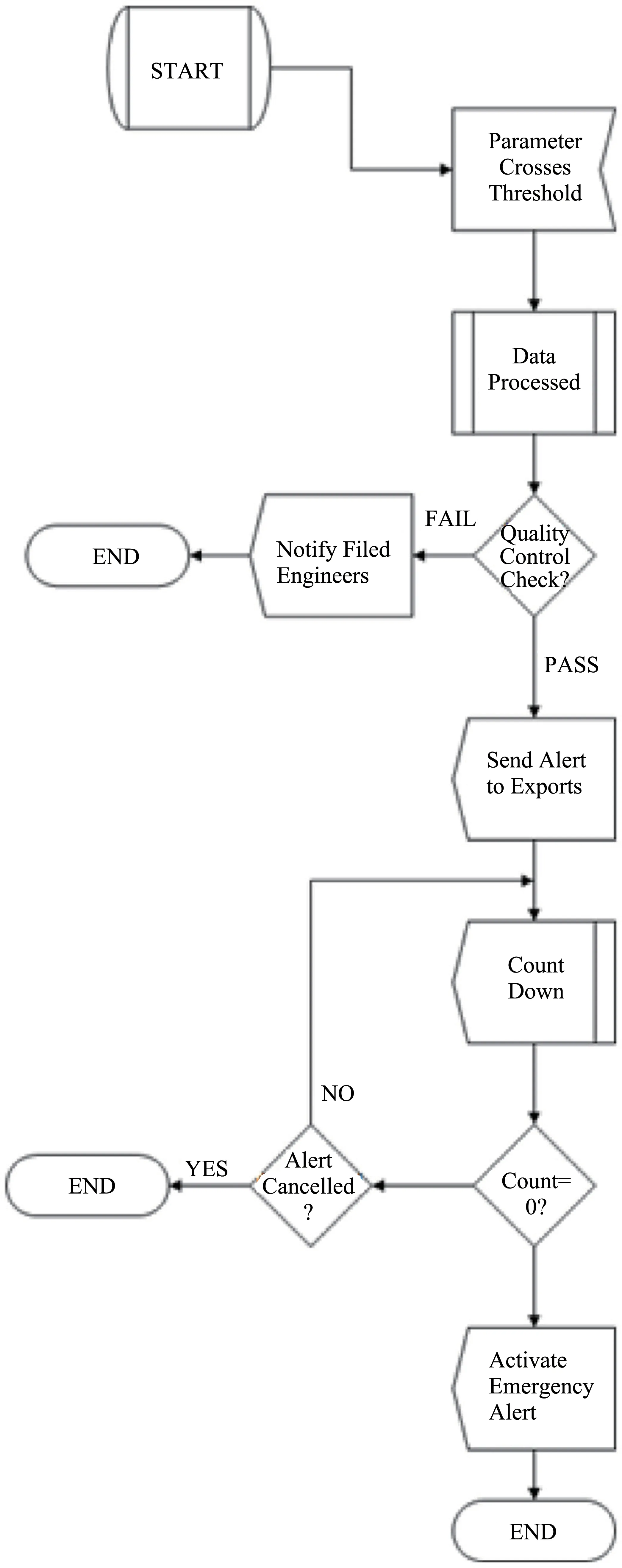
Figure 13 Flowchart of Automatic and Human Assisted Decision Support System Module
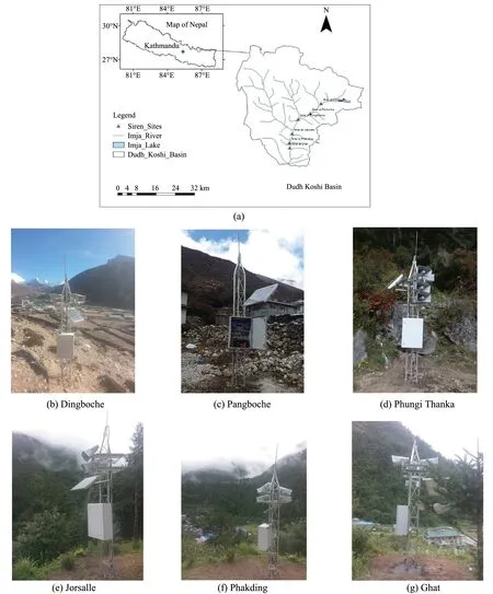
Figure 14 Automatic early warning sirens in six prime settlements of Dingboche,Pangboche,Fungithanka,Jorsalle,Phakding,and Ghat have been installed to disseminate the alert
3.2.7 Emergency alert dissemination module
After the decision support system module verifies possible threat of GLOF,the emergency alert dissemina‐tion module will disseminate emergency notifications using various media such as SMS,email,social net‐works and audio emergency notification systems in‐stalled at different locations for Dingboche,Pangboche,Fungithanka,Jorsalle,Phakding,and Ghat.The emer‐gency alert dissemination module acts as a centralized control center for activating the sirens as when required.
The module has the following features:
·Geographic information system (GIS) based ap‐plication to activate sirens at specific regions;
· Android based mobile application to receive alerts using the internet;
·Web pages for interested people to register their mobile numbers and email address to receive alerts;
·The module also supports common alerting pro‐tocol(CAP)as an automated origination.
The project has supported and trained the EWS Taskforce in vulnerable settlements who will coordi‐nate with vulnerable people during an Imja GLOF event.Furthermore,as part of the preparedness plan,numerous drill events were organized for two subse‐quent years.
4 Results
The real time data of automatic hydrological and meteorological stations have been transmitted to the hydrology server.This data can also be viewed and downloaded remotely from anywhere.The data for the period from May,2016 to July,2019 are available in an old hydrological server (http://www.wscada.net/) and from August 2019 data are available in a new hydrology server(http://daq.hydrology.gov.np/).
4.1 Hydrological data
The maximum water level for the period August 2019 to May 2020 for the Hydrological Station at Im‐ja Glacial Lake and hydrological Station at Imja Gla‐cial Lake Downstream were recorded at 1.4 m and 1.46 m on August 27,2019,respectively (Figure 15).Danger and warning level set for hydrological station at Imja Glacial Lake are 3 m and 2 m and hydrologi‐cal station at Imja Glacial Lake downstream are 4 m and 3 m,respectively.The water level never crossed the danger and warning level after the implementation of EWS.
Figure 16 shows the comparison of daily water level obtained from an automatic hydrological station and manual gauge data obtain from the Department of Hy‐drology and Meteorology (DHM) at outlet of Imja Gla‐cial Lake for April,2020.It can be seen that data given by the automatic hydrological station are very close to those obtained from the manual gauge.There is a strong,positive association between two variables(R2=0.91).
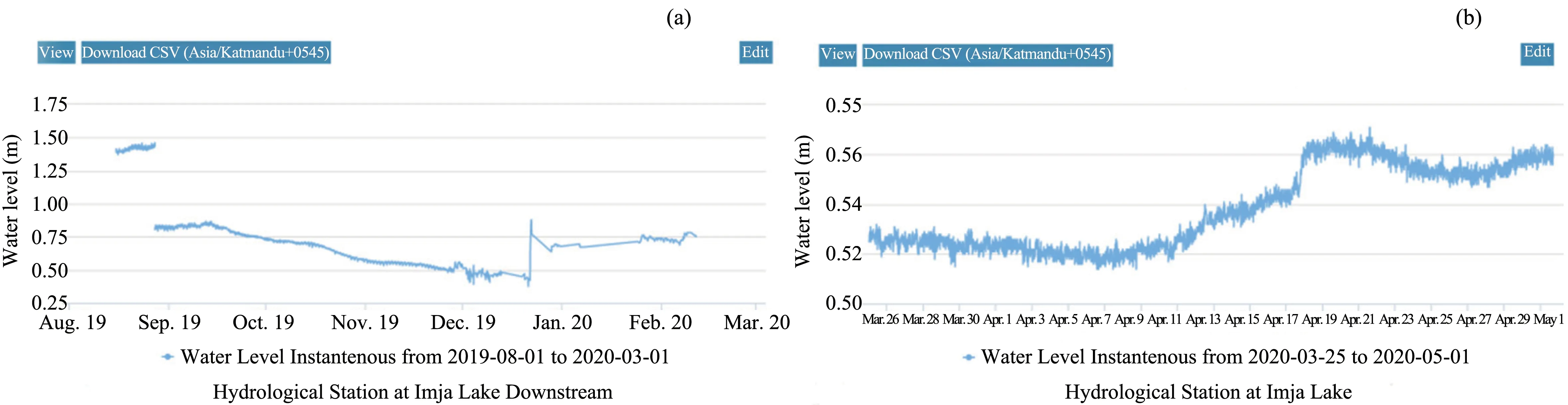
Figure 15 Graph of water level at upstream and downstream of the Imja River
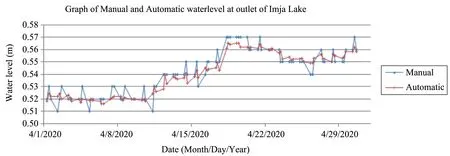
Figure 16 Comparison of daily water level at outlet of Imja Glacial Lake for April,2020
4.2 Meteorological data
Meteorological data are used to study the effects of different meteorological parameters so as to predict occurrence of any GLOF event.
Meteorological data were obtained from the auto‐matic weather station for the period from August 2019 to May 2020.The average temperature was−4.1 °C for the period of August 7,2019 to April 28,2020.The lowest temperature was −24.28 °C,re‐corded on February 9,2020,and the highest temper‐ature was 10.35 °C recorded on February 13,2020.Total precipitation at Imja was 229.3 mm for Au‐gust 1,2019 to April 28,2020.Lowest atmospheric pressure was 530.9 hPa,recorded on January 5,2020 and highest atmospheric pressure was 551.79 hPa recorded on September 26,2019.Average global solar radiation of 379.4 w/m2was recorded during August 17,2019 to April 28,2020.Average relative humidity of 64% and wind speed of 2.88 m/s was recorded dur‐ing August 17,2019 to April 28,2020(Figure 17).
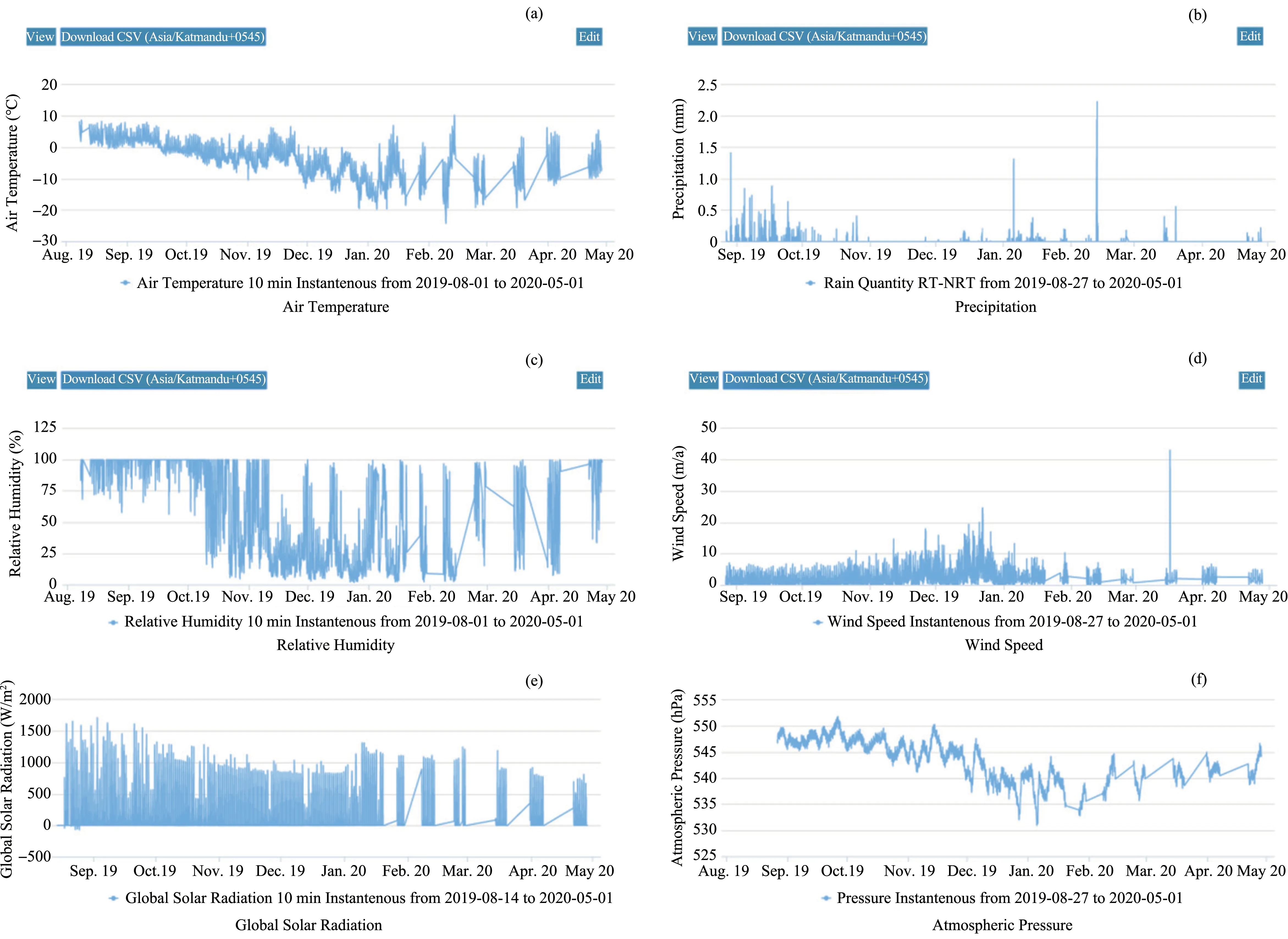
Figure 17 Graph of meteorological parameters
The recorded wind speeds and directions at Imja Glacial Lake are presented in Figure 18.For the peri‐od of August 17,2019 to April 28,2020,northwester‐ly winds dominated,with some contribution from westerly flows.The dominant wind speed ranged less than 0.5 m/s,with a maximum wind speed of up to 13.5 m/s.Katabatic wind blows down the valley dur‐ing this period.
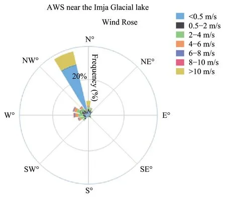
Figure 18 Distribution of wind rose at Imja Glacial Lake(August 17,2019 to April 28,2020)
5 Discussions and conclusions
An Early warning system with satellite commu‐nication technology for transmitting GLOF warn‐ing and providing automatic hydrological and me‐teorological data in real time have been successful‐ly implemented under CFGORRP of the Depart‐ment of Hydrology and Meteorology.Water level and meteorological data with 10 minute resolution is now obtained from automatic hydrological and meteorological stations.These real time water lev‐el data and meteorological data are extremely use‐ful to study the effects of different meteorological parameters so as to predict the occurrence of any future GLOF event.Previously,the GLOF Early Warning System was successfully implemented in Tsho Rolpa Glacial Lake (Shresthaet al.,2014)but one of the major challenges faced by the opera‐tional system was lack of technical expertise and manpower.Trained personnel with forecasting ex‐pertise and adequate forecast group staffing are re‐quired by the system to effectively issue timely warnings.However,74% of the flood forecasting personnel confirm that their centres do not have the experts and staff capable to integrate data,per‐form forecasts,and disseminate information (Al‐berta Water SMART,2014).In developing coun‐tries like Nepal,poor infrastructure (transporta‐tion,communication,and power),and lack of a budget for operational expenses are major limita‐tions to the proper operation of the GLOF early warning system.Despite these limitations,the ear‐ly warning system can be used for multi-hazard purpose extending beyond GLOF.These hazards include landslide,fire and flash floods.This GLOF early warning system can be upscaled to any other potentially dangerous Glacial Lake identified by ICIMOD(2011).
The objective of this article is to provide an overview of an EWS for GLOF risk mitigation in Dudh-Koshi Basin,Nepal.GLOF event is often asso‐ciated with key climatic variables such as water level,heavy rain fall and extreme high temperatures.A real time analysis of such key parameters is necessary for identifying the key parameter(s) for anticipating the occurrence of an GLOF event in the future.This arti‐cle focuses on the overview of implementation of EWS for GLOF risk monitoring.Future research should be directed towards analysis of the outputs from different components of the EWS for anticipat‐ing GLOF risks.
Acknowledgments:
We are very grateful to the Department of Hydrology and Meteorology (DHM) Nepal for implementing Community Based Flood and Glacial Lake Outburst Risk Reduction Project in collaboration with UNDP Nepal.We are also thankful to the editor and two anonymous reviewers for rendering valuable com‐ments for improving this paper.
 Sciences in Cold and Arid Regions2021年3期
- Sciences in Cold and Arid Regions的其它文章
- A concise overview on historical black carbon in ice cores and remote lake sediments in the northern hemisphere
- Summary of research on frost heave for subgrade in seasonal frozen ground
- Temporal changes in seasonal precipitation over the Sahara Desert from 1979 to 2016
- Centrifuge model test on performance of thermosyphon cooled sandbags stabilizing warm oil pipeline buried in permafrost
- Changes in morphology and soil nutrient patterns of nebkhas in arid regions along a precipitation gradient
- Linkages between soil microbial stability and carbon storage in the active layer under permafrost degradation