
Satellite-measured water vapor isotopologues across the Tianshan Mountains,central Asia
2021-02-12 03:12ShengJieWangYangSongMingJunZhangAthanassiosArgiriouYuDongShi
ShengJie Wang,Yang Song,MingJun Zhang*,Athanassios A.Argiriou,YuDong Shi
1.College of Geography and Environmental Science,Northwest Normal University,Lanzhou,Gansu 730070,China
2.Key Laboratory of Resource Environment and Sustainable Development of Oasis of Gansu Province,Lanzhou,Gansu 730070,China
3.Laboratory of Atmospheric Physics,Department of Physics,University of Patras,GR-26500 Patras,Greece
ABSTRACT The satellite-based water vapor stable isotope measurements have been widely used in modern hydrological and atmospheric studies.Their use is important for arid areas where the precipitation events are limited,and below-cloud evaporation is strong.This study presents the spatial and temporal characteristics of water vapor isotopologue across the Tianshan Mountains in arid central Asia using the NASA Aura Tropospheric Emission Spectrometer(TES).The near-surface water vapor stable isotopes are enriched in summer and depleted in winter,consistent with the seasonality of precipitation isotopes.From the surface to 200 hPa,the isotope values in water vapor show a decreasing trend as the atmospheric pressure decreases and elevation rises.The vapor isotope values in the lower atmosphere in the southern basin of the Tianshan Mountains are usually higher than that in the northern basin,and the seasonal difference in vapor isotopes is slightly more significant in the southern basin.In addition,bottom vapor isotopologue in summer shows a depletion trend from west to east,consistent with the rainout effect of the westerly moisture path in central Asia.The isotopic signature provided by the TES is helpful to understand the moisture transport and below-cloud processes influencing stable water isotopes in meteoric water.
Keywords:water vapor isotopes;satellite measurement;Tianshan Mountains;central Asia
1 Introduction
The stable hydrogen and oxygen isotopes (2H and18O) have been widely applied in modern hydrological and atmospheric studies (Aggarwalet al.,2016;Bowenet al.,2019;Jasechko,2019).Compared to precipitation which does not occur every day,water vapor provides all-weather records of the stable isotopologues all year round (Galewskyet al.,2016;Weiet al.,2019;Tianet al.,2020).In arid regions,the number of rain and snow events may not be sufficient for hydrological and atmospheric studies using isotopologues (Liuet al.,2014;Wanget al.,2016c).Additionally,the strong below-cloud evaporation may significantly modify the raindrop stable isotope composition,leading to isotopically enriched surface precipitation (Salamalikiset al.,2016;Zhang and Wang,2016;Crawfordet al.,2017).Therefore,it is clear that the water vapor isotopes measurements are of great importance,especially for arid climates.
The traditional method of assessing water vapor isotope composition is to condense atmospheric water vapor using a cold trap and determine the isotopic ratio of the condensate.This method is rather complex so it is not easy to acquire time series of vapor isotopologues with high sampling frequency for an extended period and extensive spatial coverage (Rahulet al.,2016;Wuet al.,2019).In the past one or two decades,laser-based isotope spectrometry greatly increased the temporal resolution of vapor isotope measurements,and can acquire vapor isotope data at a frequency of approximately 1 Hz (Yaoet al.,2018;Leroy-Dos Santoset al.,2020;Liet al.,2020;Munksgaardet al.,2020).However,this is costly equipment,and therefore the available time series worldwide are scarce (Weiet al.,2019).The satellite-based vapor isotope measurement is a viable alternative,which can provide concurrent water vapor isotopologues at a larger spatial coverage,although the temporal and spatial resolutions are usually low (Liuet al.,2014;Baileyet al.,2017;Wordenet al.,2019;Schneideret al.,2020).Among the available instruments,the Tropospheric Emission Spectrometer(TES),an infrared spectrometer aboard the NASA Aura spacecraft,has been widely used because of its long-term operation and data accuracy (Wordenet al.,2011;Leeet al.,2012;Fieldet al.,2014;Lacouret al.,2018;Shiet al.,2020).
In central Asia,where the marine moisture can be hardly transported inland,the annual precipitation is usually less than 200 mm (Yanget al.,2020).Consequently,the meteoric water availability and the hydrological cycle are always a hot topic for this region(Yaoet al.,2019,2020).The Tianshan Mountains is a westeast mountain range located in arid central Asia.The Tianshan Mountains,with much higher annual precipitation than that across the surrounding basins or plains,are the origins of many rivers.For the oases along the northern and southern slopes of the Tianshan Mountains,precipitation is the critical resource for regional sustainability,and the stable isotopologue in precipitation and water vapor is helpful to understand the moisture source and sink (Zhang and Wang,2018;Yaoetal.,2021).In addition,the Tianshan Mountains lie at the core region of the westerlies Asia as opposed to monsoonal Asia (Chenet al.,2019),and the modern isotopic measurements are also needed to explain the isotopic signals in climate proxies acquired from this region(Raoet al.,2019,2020;Wanget al.,2021).
During the past decades,a number of precipitation isotope measurement campaigns were carried out across the Tianshan Mountains in central Asia (Wanget al.,2016c;Bershaw,2018;Juhlkeet al.,2019;Yaoet al.,2021),to understand the moisture transport path(Wanget al.,2017,2020;Shiet al.,2021),the local moisture recycling (Kong and Pang,2016;Wanget al.,2016a) and the below-cloud secondary evaporation(Kong and Pang,2016;Wanget al.,2016b)in the westerlies-dominated region.However,the in-situ observation of isotopic ratios in water vapor is still limited in arid central Asia (Yuet al.,2016;Weiet al.,2019),and it is significant to assess the essential characteristics of water vapor isotopologues using satellite-based measurements.In this paper,the TES database is used to investigate the spatial pattern and temporal variability of stable hydrogen isotope composition in water vapor across the Tianshan Mountains in arid central Asia.
2 Data and methods
This study focuses on the rectangle area within 75°E to 95°E and 38°N to 48°N (Figure 1).Because of the geomorphology,the Tianshan Mountains roughly divide this region into the northern part (including the Balkhash-Alakol Basin and the Junggar Basin)and the southern part (including the Tarim Basin and the Turpan-Hami Basin).Furthermore,due to the rain shadow effect of the Qinghai-Tibet Plateau,the southern basin of the Tianshan Mountains is much drier than the northern basin(Huet al.,2018;Yaoet al.,2020).
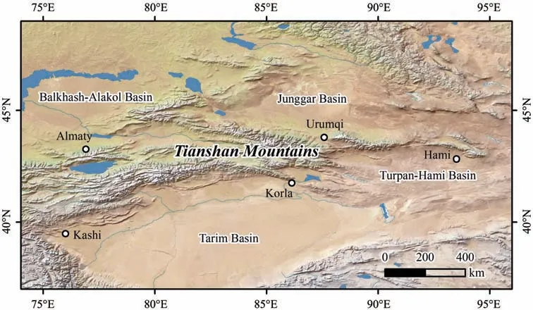
Figure 1 Location of the Tianshan Mountains in central Asia
The TES Level 3 (L3) product comes from an infrared spectrometer aboard the NASA Aura spacecraft.In this study,we used a compiled database of TES L3 available at the Giovanni version 3(Goddard Earth Sciences Data and Information Services Center,Interactive Online Visualization and Analysis Infrastructure).The algorithm for obtaining this data is Delaunay triangulations on a latitude and longitude plane,which is followed by 2-D interpolations for fixed pressure levels(Wordenet al.,2006).The water vapor and deuterium oxide measurements are available for 15 pressure levels,namely,825 hPa,681 hPa,464 hPa,316 hPa,215 hPa,146 hPa,100 hPa,68 hPa,46 hPa,32 hPa,22 hPa,15 hPa,10 hPa,7 hPa,and 5 hPa.The TES data can describe the main spatial pattern of vapor isotopologues,especially on a large spatial scale with acceptable accuracy (Wordenet al.,2011;Zhanget al.,2012;Hermanet al.,2014).In this study,considering the data availability,the period from September 2004 to December 2010 is selected.
The isotopic ratio in water vapor is expressed as a delta (δ) notation with respect to Vienna Standard Mean Ocean Water(VSMOW):

whereq(1H2HO) andq(1H2O) stand for the specific humidity of1H2HO and1H2O in water vapor,respectively,andRthe isotopic ratio of1H2HO/1H2O in VSMOW.
3 Results and discussions
3.1 Vertical profile of isotopologues in water vapor
Figure 2 shows the monthly variations of precipitable water amount across the Tianshan Mountains in central Asia from September 2004 to December 2010 provided by the TES L3 database.In the study region,the atmospheric moisture loading exhibits seasonal variability.On an intra-annual basis,the atmospheric precipitable water shows a maximum in summer (July)and a minimum in winter(January).
Figure 3 shows the vertical profiles ofδ2H in water vapor in January and July across the study region.The months with less than five daily values are not included;we selected the years of 2005 (14 days in January),2006 (15 days),2007 (15 days) and 2008(14 days) for the January profile (Figure 3a) and 2005(14 days in July),2007 (15 days),2008 (15 days) and 2010 (15 days) for the July profile (Figure 3b).For these four years' data shown,the vertical profiles of water vapor isotopologues are generally similar,especially for the lower part of the air column.From the surface to 200 hPa,the isotope values in water vapor show a decreasing trend as the atmospheric pressure decreases and elevation rises.The isotope ratio reaches a minimum at heights around 100 hPa,but increases at higher elevations,revealing enriched water vapor.At the lower atmosphere,i.e.,around 825 hPa,the meanδ2H value in water vapor is lower than-100‰ in January and larger than -100‰ in July,which is consistent with the seasonal variability of stable isotopes in precipitation (enriched in summer and depleted in winter) (Wanget al.,2016c).This known seasonal variation reflects the influence of the westerlies'moisture(Tianet al.,2007;Yaoet al.,2013;Wanget al.,2017).According to the daily counts of valid TES data for each year,2007 (179 days) has the best temporal coverage.We selected this year to obtain a continuous annual profile (Figure 4).At the lower atmosphere,water vapor isotope ratios shows a clear seasonal variation,which weakens as the elevation rises.Near 825 hPa,theδ2H value in water vapor is higher than-100‰from May to September.
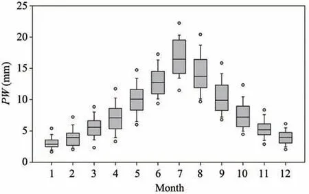
Figure 2 Box plot showing the monthly variations of precipitable water amount(PW)across the Tianshan Mountains(The top and bottom of a box represent the 25th and 75th percentiles,and the horizontal line within a box represents the median;the whiskers show the 90th and 10th percentiles,and the empty points above and below the whiskers are the 95th and 5th percentiles)
3.2 Spatial pattern of isotopologues in water vapor
To understand the spatial pattern of water vapor stable isotope composition across the study area,we focus on the two tropospheric pressure levels,i.e.,at 825 hPa (approximately 1,700 m a.s.l.) and 681 hPa(approximately 3,000 m a.s.l.)(Figure 5).Considering the pressure near the surface at some mountainous regions drops,we masked the areas with an elevation higher than 1,700 m and 3,000 m (in white shades) in the respective charts.At the 825 hPa level(Figure 5a),a low-value belt (less than about -126‰ forδ2H)along the Tianshan Mountains appears in January.This low belt withδ2H <-170‰ remains at the 681 hPa level (Figure 5d).In contrast,the high-value region is observed at the southern margins.In July,the low-value region moves at the northeastern part for both the 825 hPa (Figure 5b) and the 681 hPa (Figure 5e) level,while the high-value region is observed at the southwestern corner.Regarding the intra-annual variations,the difference between January and July(January minus July) shows very negative values at the southwestern part of the study region (Figures 5c and 5f),indicating a significant seasonal difference in this region where the rain shadow effect manifests clearly.
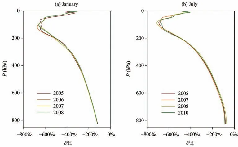
Figure 3 Vertical profiles of δ2H in water vapor across the Tianshan Mountains:(a)January 2005,2006,2007 and 2008,(b)July 2005,2007,2008 and 2010
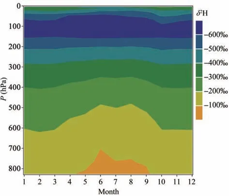
Figure 4 Monthly variation of the vertical profile of δ2H in water vapor in 2007 across the Tianshan Mountains
In many stable isotopologue studies in precipitation in arid central Asia or over a larger domain,including high mountain Asia (Liuet al.,2008;Wanget al.,2016c;Zhang and Wang,2018),the stable isotope ratios in precipitation over the Tianshan Mountains is usually low.The strong below-cloud evaporation in the low-lying basins increases the isotope ratios in precipitation,which is more significant at the southern basin where the air temperature is higher and humidity is lower than at the northern basin (Kong and Pang,2016;Wanget al.,2016b).Generally,the isotopologues in atmospheric water vapor in this study are consistent with those observed in precipitation near the ground.In a previous isotopic modelling study along the northern and southern oasis belts near the Tianshan Mountains (Wanget al.,2016b),the raindrops below cloud base were found to have similar isotope values over the various sub-regions,and that below-cloud evaporation greatly modifies the isoscapes in surface precipitation.In this study,spatial incoherence across arid central Asia does exist.However,if only the narrow oasis belts are considered,the isotopic pattern may confirm the previous prediction to some degree (Wanget al.,2016b).The great seasonal difference of stable isotopes in precipitation in arid central Asia is observed in some nationwide and continental studies(Araguás-Araguáset al.,1998;Liuet al.,2014),which is generally consistent with the findings of this study.
Figure 6 shows the seasonal isotopic variation in water vapor along the meridional and zonal gradients.Generally,the seasonality of water vapor isotopologues is more obvious at lower latitudes (Figures 6a and 6c)and lower longitudes (Figures 6b and 6d).For example,at 825 hPa,the summer vapor isotopes are much enriched (>-80‰)at latitudes lower than 42°N,but the summer vapor isotope values in the northern areas are much lower.In addition,different latitudes usually correspond to different isotopologues within the study region.In contrast,the variation for different longitudes is not so pronounced.
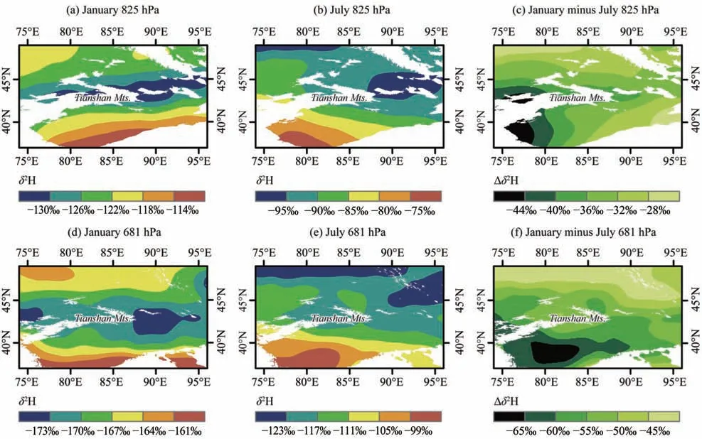
Figure 5 Spatial distribution of δ2H in water vapor at 825 hPa(a,b and c)and 681 hPa(d,e and f)in January 2007(a and d)and July 2007(b and e)and their difference(c and f)across the Tianshan Mountains
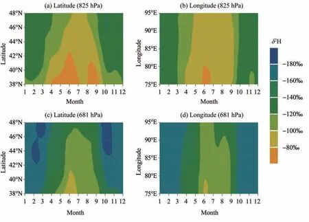
Figure 6 Monthly variations of δ2H in water vapor at 825 hPa(a and b)and 681 hPa(c and d)in 2007 for different latitudes(a and c)and longitudes(b and d)across the Tianshan Mountains
We also showed the vertical profiles of water vapor isotopologues along the meridional and zonal gradients (Figure 7;the layers higher than 316 hPa are not shown).The upper atmosphere usually presents a relatively stable condition all year round,while the lower atmosphere shows the well-known seasonal variability.In Figure 7b,as an air mass moves from south to north in summer,that is,when the latitude increases,the stable isotopes in water vapor at the lowest air column show a depleting trend.In contrast(Figure 7a),the variation is generally weak in winter when the moisture flux is low.Regarding the westerlies path,as an air mass moves from west to east,that is,the longitude increases,the water vapor stable isotopes near the surface also show a depleting trend in summer (Figure 7d).Still,there is no apparent lapse rate in winter (Figure 7c).The latitude and longitude gradient of stable isotopes in vapor in Figure 7d corresponds to the main moisture trajectories as well as the rainout effect in arid central Asia (Wanget al.,2017,2020);stronger moisture transport in summer corresponds to a more obvious depleting trend in heavy isotopes,which may be very weak in winter with low moisture loading (Wanget al.,2017).The depleting trend in precipitation isotopes along the trajectories of westerlies have been observed across the Tianshan Mountains (Wanget al.,2017),and similar trends in water vapor isotopes are also detected here.
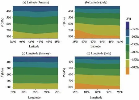
Figure 7 Variations of the vertical profile of δ2H in water vapor in 2007 for different north latitudes(a and c)and east longitudes(b and d)across the Tianshan Mountains
4 Conclusions
Although the traditional methods based on mass or laser spectrometry may provide isotope values and hydrological information at a high temporal resolution,they are not always suitable in describing the large-scale isotopologue patterns.This study analyzes the essential characteristics of water vapor isotopes across the Tianshan Mountains in arid central Asia using data from the NASA Aura Tropospheric Emission Spectrometer.The stable isotopes in water vapor are enriched in summer and depleted in winter,consistent with the seasonality of precipitation isotopes.The vapor isotopes of the near-surface water vapor in the southern basin are usually more enriched than that in the northern basin,and the seasonal difference in vapor isotopes is slightly larger in the southern basin.Similar to the previously observed depleting trend in precipitation isotopes along the westerlies path,the summer isotopologue in water vapor also exhibits a depleting trend from west to east.The satellite-based isotopic series are useful to detect the moisture transport and below-cloud effects and to understand the isotopic fractionation in meteoric water from vapor to precipitation.
Acknowledgments:
This research was supported by the National Natural Science Foundation of China (Nos.41971034 and 41701028),the Foundation for Distinguished Young Scholars of Gansu Province (No.20JR10RA112),and the Northwest Normal University (No.NWNULKZD2021-04).We thankfully acknowledge that Giovanni (GES-DISC Interactive Online Visualization and Analysis Infrastructure) version 3 provided the TES Level 3 data.The background map was based on Natural Earth(http://www.naturalearthdata.com).
 Sciences in Cold and Arid Regions2021年6期
- Sciences in Cold and Arid Regions的其它文章
- Cryogenic wedges on the NE Qinghai-Tibet and Ordos Plateaus:Their characteristics,origin and OSL dating
- High-precision measurements of the inter-annual evolution for Urumqi Glacier No.1 in eastern Tien Shan,China
- Editor-in-Chief Yuanming Lai
- Climate response and radial growth of Pinus tabulaeformis at different altitudes in Qilian Mountains
- Long-term effects of gravel-sand mulch thickness on soil microbes and enzyme activities in semi-arid Loess Plateau,Northwest China
- Seasonal variation of airborne fungi of the Tiantishan Grottoes and Western Xia Museum,Wuwei,China