
Cryogenic wedges on the NE Qinghai-Tibet and Ordos Plateaus:Their characteristics,origin and OSL dating
2021-02-12 03:12StuartHarris
Stuart A.Harris
Department of Geography,University of Calgary,Calgary,Alberta,T2N 1N4,Canada.
ABSTRACT Cryogenic wedges developed due to very cold,rather arid conditions during the maximum of the last cold event when the drying up of the neighboring China Sea resulted in the failure of the East Asian Monsoon.As the climate ameliorated and the Monsoon rains reappeared,ice-wedges developed.Further warming permitted thawing of the ice infillings accompanied by replacement of the ice by sediments partly from the host ground as well as from the surface by wind or sheet wash.In cases of extreme surface water flow on slopes after 10 ka B.P.,small baydjarakhs typically c.50 cm high developed,only to have the resulting hollows infilled by sediments carried by wind and/or sheet wash.These shallow structures form a network on top of many of the cryogenic wedges.This complex history makes dating the ages of the wedges difficult using OSL methodology.Unfortunately,past field work ignored the problem of the angle of the cut face to the direction of the wedge infilling when sampling the contents of the narrow wedges,resulting in potential contamination of the samples with the host sediment.Sampling of the larger deposits should be alright,but the likelihood of contamination makes the interpretation of the resulting OSL dates from the narrow wedges questionable.Primary wedges consisting of primary mineral infillings should still have similar OSL dates with depth for a given wedge,but the distinction between ice-wedge infillings and soil wedges is difficult since both can exhibit older dates of the infillings with depth.The available data suggests that ice-wedges were significantly more common than sediment-filled primary wedges.A protocol to avoid having to obtain large numbers of OSL dates by more careful field sampling and the use of grain size determinations is provided in the Appendix.
Keywords:cryogenic wedges;OSL dating;NE Qinghai-Tibet Plateau;differentiation of primary and secondary wedges;baydjarakhs in arid climates
1 Introduction
Cryogenic wedges are wedge-like structures developed in the ground by thermal contraction cracking.Vandenberghe and Pissart (1993) regarded them as being one of the most obvious lines of evidence for the former presence of permafrost.They are typically up to 4 m in depth but of varying widths and shapes.They are found in three regions of the world with different climates and processes.Most studies have been carried out on those of the maritime and humid regions of the cold Arctic coast in the northern Hemisphere.Their resulting structures are widespread in the remains of late Pleistocene deposits across northern Europe in front of the former ice sheets,but they are very different from the cryogenic wedges that occur on the more arid,high northeastern slopes of the Qinghai-Tibet Plateau and also on the lower Ordos Plateau in China.The third region of occurrence is Antarctica (Péwé,1959),northern Alaska (Carter,1981;1983) and Prince Patrick Island,Northwest Territories (Pissart,1968).Subsequent work invokes sublimation of ice in Antarctica (Halletet al.,2011)while additional work is needed to clarify the processes involved in Alaska and Prince Patrick Island.All three areas have different climates and resulting processes that produced the wedges.In this paper,the characteristics,origins and problems of dating the cryogenic wedges of NE Qinghai-Tibet in China are examined after a brief summary of the characteristics of those around the Arctic Basin which are far better known.
1.1 Characteristics of the cryogenic wedges around the Arctic Basin that are also found as relict structures in the late Pleistocene sediments of Northern Europe
The northern wedges around the Arctic Basin form today in very wet cold conditions,particularly in maritime situations.When the former ice sheets melted,it produced extremely complex structures that occur in Pleistocene sections from Belgium to Poland and are described in the literature,e.g.,the journalBiuletyn Periglacjalny.Murton and French (1993) also provide good examples from the Mackenzie Delta.The processes involved include thermal erosion,subsidence,refreezing,loading,collapse,heaving.buoyancy,spreading,shearing,and folding.Popov (1962),Dostovalov and Popov (1966),and Shumskii and Vyturin (1966) regarded cryogenic wedge ice as also being the dominant type of underground ice remaining in central and northern Siberia.However,when massive icy beds and yeodoma are removed from those structures,the remaining frequency of ice wedges constitute only 20%-35% of the total ice volume in the upper 5-10 m in these areas (French,2006,pp.176).Primary cryogenic wedges infilled by mineral sediments excluding ice-wedges also occur but are rare.Dating is relatively easy since organic remains are well preserved in these environments.
1.2 Cryogenic wedges in Northeast Qinghai-Tibet
These differ from those in the Arctic by being formed under very cold,relatively arid conditions at high altitude and low latitude that do not occur there today,partly as a consequence of the reappearance of the East Asian Monsoon.During the period from 30 ka to 19 ka B.P.,the East China Monsoon failed because the adjacent China Sea became dry land (Voris,2000;Harris and Jin,2012).The only wedges formed during this period were the rock tessellons reported by Harris and Jin (2012) from the west side of the Ngörring lake.The conditions changed abruptly when the level of the China Sea started to rise permitting the East China Monsoon to become reactivated.It was still very cold in winter but the coming of the monsoon added heat and moisture to the climate allowing the infilling of the annual contraction cracks by ice.The extreme fluctuating conditions conducive for thermal contraction cracking continued until the ground temperature had increased sufficiently,and this was followed by a period of stability.Further warming resulted in the thawing of the ice wedges from the top down,permitting infilling by sediment from the walls and the surface sediments.The resultant structures consist of a simple V-shaped wedge up to 3 m in depth,often with a bowl-shaped top which is often occupied by a much younger sediment (Heet al.,2020a;2020b).Minor wedge-like structures up to about a metre deep have usually been regarded as being of Neoglacial age (Chenget al.,2005a,2006;Heet al.,2020a)or the early Holocene.In this rather arid environment organic matter is rare so that OSL dating is usually employed to attempt to obtain an idea of the ages of the infillings.
1.3 The thermal contraction cracking process
Thermal contraction cracking occurs when the moist or wet active layer is subjected to very cold air temperatures(Leffingwell,1915,1919).It can also occur under very dry conditions since it is the result of stresses produced by thermal contraction of a sediment or rock that is being subjected to sufficiently extreme thermal contraction that the tensile strength of the material is exceeded.When the ground temperature decreases in the fall,the ground contracts,but after the ground temperature falls below -15 °C and most of the moisture in it changes to ice,the material becomes very brittle (Dostovalov,1952;Lachenbruch,1962;Péwé,1966).If the temperature continues to fall slowly,the layer tends to contract,but this sets up horizontal stresses.These are partly offset by the creep of ice,so that if the stresses do not exceed the tensile strength of the ground,cracking does not occur.This is the situation today in Northeast Qinghai-Tibet Plateau.However,if there is a sudden decrease in temperature from 20 °C to below 32 °C,cracking takes place(Allard and Kasper,1998;Fortier and Allard,2008).Mackay (1993b) suggested that the temperature drop producing the cracking should be about 1.8 °C/day for at least 4 days.Ice-wedges form mostly during extreme temperature fluctuations varying from a few days to a one to two-week period.Without these extreme temperature fluctuations,cracking does not occur.The thermal stresses are proportional to the rate of change in ground temperature,the temperature gradient with depth,the depth below the surface,modulus of elasticity,and coefficient of expansion of the soil components.Most minerals have a coefficient of thermal expansion of 2-12×10-6/1°C,whereas ice has values of 30-60×10-6/1°C,depending on the structure of the ice,the angle of the optical axis of the crystals,the temperature,and potential phase changes altering its volume.Air,which does not freeze,has a very high capability for expansion or contraction.With all these variables,it is not surprising that cracking is not readily predictable,is not entirely controlled by temperature,and does not happen every year along any given crack (Mackay,1974,1989,1992;Harryet al.,1985).Mackay (1984)showed that the cracking starts some distance below the ground surface and propagates both up and down.Accordingly,infilling of the resultant crack can begin part way down the crack with collapse of the walls of the host sediment if it is suitably wet or fractured.
Depth of cracking is closely related to the average annual ground temperature (Dostovalov,1952),The distance between polygons increases with lower average amplitude of ground temperature fluctuations,varying from 0.5 to 10 m in areas in continental climates to 20-80 m in less continental situations (Grechishchev,1970).In Siberia,width of annual cracking is 5-10 cm maximum,with a depth of 3-4 m.The cracking takes the form of a polygonal network,usually with 5 sides,but 4-8 sided polygons can occur.Each side is straight unless the polygon has grown on undulating land.At 1,000-1,500 m elevation on the Ordos Plateau in China,the shape is similar and two sizes of wedges have been described (Cui and Xie,1984;Cuiet al.,2004;Vandenbergheet al.,2004;Vandenburgheet al.,2019).The large wedges extend to depths of 2-4 m and form large polygons 5-8 m diameter with distances up to 14 m between adjacent wedges.The bedding immediately adjacent to some of these wedges shows typical upturning.The finesandy filling material is of dominantly aeolian origin.Smaller wedges no deeper than 1.5 m spaced 1.5-2 m also occur and are believed to be of Neoglacial age.Truncated sand-filled wedges also have been reported from West of Lake Ngörring at c.4,300 m elevation(Harris and Jin,2012).They had a spacing of up to 15 m.
Western Siberia experiences cracking in peat at mean annual temperatures below 2°C,compared with-6°C in alluvial sandy loams.In Siberia,the southern boundary of significant frost cracking corresponds to the average annual air temperatures (MAAT) of -5 to-6°C(Romanovsky,1974).However,the key to cryogenic wedge distribution remains the very extreme change in temperature,not the relationship to freezing and thawing indices,nor mean annual air temperature(Figure 1).When Amsterdam (Holland) experienced a sudden,extreme cooling event one year,the ground cracked(Washburnet al.,1963).
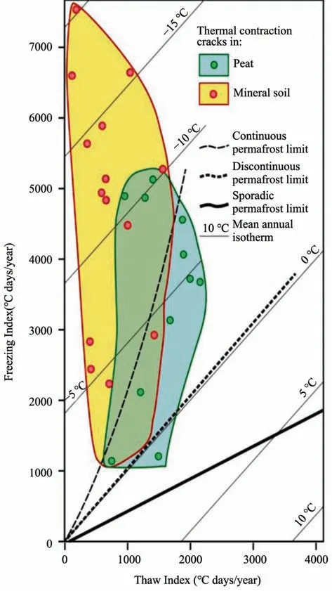
Figure 1 Relationship of thermal cracking of peat and mineral soil to mean annual freezing and thawing indices and permafrost zones(Harris et al.,2017)
1.4 Types of cryogenic wedges and their recognition
Romanovskii (1977) subdivided the wedges in Siberia extending into permafrost into primary wedges containing the initial filling of the thermal contraction cracks and secondary wedges consisting of the secondary fill of sediment after the ice has thawed.Earlier,Dylik (1966) had introduced the term soil wedges for wedges occupying only part of the active layer.
Primary wedges usually exhibit vertical foliation and can have a filling consisting of sand,silt,loam,rocks or ice.The infilling comes from above ground,so OSL or14C dates should be reasonably consistent throughout the depth of the wedge infilling.In this case,the dating provides the approximate age of the contraction cracking and annual infilling as long as the OSL signal has been reset.However,it is also possible in primary wedges with a mineral infilling that part of the latter came from the host rock by erosion.In epigenetic wedges,the bedding in the adjacent host sediment is usually turned upwards,if it is present.Unfortunately,it seems that some primary wedges may not always exhibit foliation of the infilling,in which case,they cannot be differentiated from secondary wedges except for the relative consistency of the ages from different levels in the wedge together with the lack of inclusions of host sediment.They are usually narrower than secondary wedges on average.Surprisingly,this difference between both the vertical consistency or otherwise of dates from infillings of primary and secondary wedges and the presence or absence of mixed origins of the infilling sediment have generally been ignored during the past interpretations of the origins of primary and secondary wedges in the Chinese literature.In the case of secondary wedges,the infilling sediment often comes partly from the walls of the host material(see section 3.1 below),usually from collapse or flowage of the walls of the host sediment,or by a combination with sediment falling in as blocks from the walls at the surface.Secondary wedges will normally show considerable variation with a general increase in age with depth in the zone of mixed infilling that is partly from the host sediment.As a result,the dating results from secondary wedges are difficult to use to date when the original ice-infilling thawed and also when the original cracking took place.The infillings of secondary wedges do not exhibit foliation and often exhibit mottling due to blocks of host sediment or rock.
Further complications stem from the possible presence of soil wedges (Wolfeet al.,2018;Vandenbergheet al.,2019)that develop entirely in the active layer.These are active today in areas of discontinuous or sporadic permafrost,e.g.,Iceland,and in the aeolian sand areas of the Northwest Territories.They are up to 1.5 m long and appear in sedimentary sections as in the case of both secondary wedges and the primary wedges that lack foliation.They must therefore be identified using other evidence as discussed above.
1.5 Terminology of these cryogenic wedges
Since the pioneer work of Cuiet al.(2004) and Vandenbergheet al.(2004),most cryogenic wedges in China have been referred to as "sand wedges".As French (2006,pp.117) admits,"this is somewhat of a misnomer" since the infilling is often of a texture other than sand.Since Chinese scientists rarely carry out grain size analyses,readers should be wary when reading the literature.It is probably best to use the terms "primary or secondary tesssellon" (AGI,2005),"ice-wedge cast" and "soil wedge" when the type of the wedge is known,and to reserve the term "sand wedge" for those of uncertain or nonproven origin.This terminology will be followed in the following discussions.
2 Materials and methods used
Cryogenic wedges are found in Northeast China on the floors of the outer basins on the Northeast slope of the Tibet Plateau (Harris and Jin,2012) as well as along the valley walls of the Yellow River downstream of Lanzhou (Cuiet al.,2004;Vandenbergheet al.,2004;Heet al.,2020a).Today,the climate is too warm for the cracking to develop,so these structures were formed when the extremely cold and dry climate of the Last Glacial Maximum started to ameliorate.They are developed in the surficial sediments consisting of fine sand and coarse silt in various proportions as well as in networks of polygonal cracks partly in metamorphic bedrock.The vegetation cover varies from steppe grassland at the higher elevations and along the Yellow River to semidesert on the Ordos Plateau.
To help understand the origin of these structures in China,it is helpful to examine the processes seen today in the Yukon Territory where ice wedges are widespread in the mountains traversed by the Dempster Highway.The Blackstone River flows north from the North Fork Pass in a deep U-shaped valley with alpine meadows and permafrost.The soils consist of a thin peat cover over an ice-wedge network.The climate is no longer cold enough for seasonal frost cracking to be active in winter,but the ice-wedges are stable if not interfered with.In one place,a contractor had scalped the wedges and it was possible to watch the thawing that ensued,while during another year,the road repair crew replaced a culvert at too low a level resulting in erosion to the new base level of the culvert during the runoff during the following spring thaw of the snow pack.
As regards the Optically Stimulated Luminescence (OSL) dating of the wedge structures and adjacent sediments in China,there is a sampling problem(see section 3.3 below) although the laboratory analysis appears to have been adequately honed.
3 Results
3.1 The effect of scalping ice-wedges
Figure 2 shows the effects of scalping the tops of ice-wedges developed in south-facing alluvial fans along the Dempster Highway beyond the North Fork Pass along the Blackstone River.The ice wedges were not obvious under the lush tundra meadow vegetation cover.The photograph was taken one day after the scalping,and already,the ice in the upper part of the wedges had melted and the resultant water was absorbing solar heat.The wedges in the foreground are exhibiting blocks breaking off from the host sediment that are sliding into the water and sinking down to the bottom of the wedge as described by French (2006).The blocks consist of an outer surface that may have its luminescence reset,as well as sediment that has not been exposed to light during its relocation.Thus,older luminescence dates will be present at the base of the wedge together with younger hybrid dates from the upper layers of the infillings.
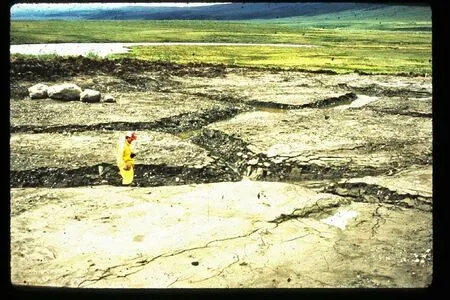
Figure 2 The result of removing the surface soil over ice-wedges along the upper Blackstone River valley,Dempster Highway,Yukon Territory.Note the rapid thawing of the exposed ice resulting in mounds of frozen soil in between the wedges.©O.L.Hughes.The edges of the host sediment are stable in the rear polygons but exhibit breakage into blocks that slide into the cavity in the foreground
Where the infill comes from thawing of the sidewalls of the cavity,the OSL date will tend to be that of the host sediment.Thus,these infillings cannot yield the actual date of the thawing of the ice-wedges nor the age of the cracking,and they will usually show variable ages of the infilling increasing with depth.
3.2 Effects of surface water eroding the tops of ice-wedges
Figure 3 shows the results of meltwater from thawing snow-packs on the nearby alluvial fans changing from sheetwash to concentrated gulley erosion along the weak depressions overlying ice-wedge polygons.The water was being held up by the limited capacity of an ice-filled culvert passing under the Dempster Highway north of the North Fork Pass.The repair crew placed the culvert too low,resulting in deeper than normal erosion prior to the road being washed out.This has produced incipient baydjarakhs close to the culvert,grading up slope into high-centre polygons which,in turn,grade up slope into alluvial sediment overlying ice-wedge polygons and ultimately into normal alluvial fans with a meadow tundra vegetation cover.
The mounds are developing into baydjarakhs by slope wash processes,similar to those found in disturbed lowland areas exhibiting thermokarst in Siberia (Figure 4).In Figure 3,the flowing water produced the gulley patterns which has a similar bowlshaped cross-section to those seen at the tops of many cryogenic wedges in China.Upslope,smaller crosssections with height-to-width ratios like the bowlshaped infilled the tops of many of the wedges in China.The ice-wedge is present beneath the trough at depth although it has been replaced by slumped host sediment near the culvert.In this situation in Russia,the depressions are soon smoothed over with sediment by slope wash and become largely revegetated.
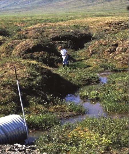
Figure 3 Results of placing a road culvert too low in an area of ice-wedges along the Dempster Highway,Yukon Territory,after one year.The hydrological disturbance decreases with distance upslope from the culvert.©S.A.Harris
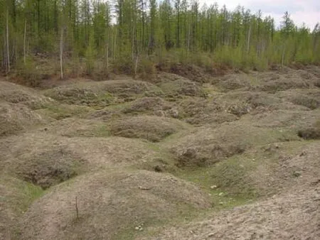
Figure 4 Baydjarakhs(thermokarst mounds)in Siberia.©A.Brouchkov
If the ice-wedges are in an area lacking a closed vegetation cover such as in the NE Qinghai-Tibet which are currently subject to monsoonal summer rains,the bowl-shaped forms found at the tops of cryogenic wedges could have formed by water erosion during extreme monsoonal events.Subsequent sheet wash and aeolian action fill in the troughs would produce a network of bowl-shaped younger sediment on top of the former or buried ice wedges.They will not usually show up on aerial photographs or at the ground surface except as a wedge pattern of slightly lower surface topography.This is the most likely origin of the bowlshaped tops of the cryogenic wedges described by Chenget al.(2005a;2005b;2006),Vandenbergheet al.,(2004),and Heet al.,(2020) and represents the end stage of thermokarst over pre-existing tessellons(cryogenic wedges) in arid,subtropical environments.The infilling may consist of aeolian sediment and/or sediment washed in by surface water flow.
3.3 Accuracy and reliability of the results of past OSL measurements in China
3.3.1 Problems with field methods of sampling for OSL dating
The sides of the polygonal wedges intersect the cut faces of sections in the field at angles anywhere between 1° and 179° .The apparent width of the wedge depends on the angle,being narrowest at an angle of 90° but appearing to become wider as the angle either increases or decreases from a right angle.Figure 5 shows the effect of inserting a 30 cm cylinder with a diameter of 10 cm into a 15 cm wide wedge at angles of 30°,90°,and 120°.Only the 90° angle will load the wedge infilling into the cylinder.The 120°angle will load part of the host sediment into the cylinder together with some of the infilling while the 30°angle results in dominantly sampling the host sediment.If the end 10 cm of the cylinders are discarded,only the 90° sample will consist of pure wedge infill.There is very limited tolerance of this angle to avoid a hybrid sample being used for laboratory analysis(about 78°-102°).Often the discarded sample may only consist of 2 cm length at each end (Heet al.,2020b) which reduces the tolerance for a pure sample of the infilling to only about 88°-92°.Certainly,changing the cross-sectional shape of the sampler to a rectangle and using it with the long sides vertically placed could improve the sampling.Unfortunately,this sampling problem raises serious questions about the true OSL date from all the samples taken from the narrow parts of wedges in the past as well as the conclusions reached based on this data in many past studies.The cylinder is 30 cm long by 10 cm diameter.To get a true sample of the wedge in the central 10 cm of the cylinder,the angle needs to be between 78° and 102°or the sample will contain some or all of the host sediment.Below 30°,the sample will consist of only the host sediment.Decreasing the length of the sample cut-away from the ends of the cylinder increases the problem.
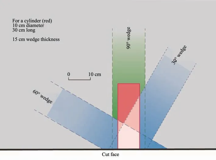
Figure 5 Plan view of the effect of the angle between the direction of the wedge(15 cm wide)and the cut face on the resulting contents of the cylinder(in red)pushed into the cut face of a section
Until now in China,the face of the section with the desired sediments is cleaned and photographed.A 30 cm long aluminium cylinder is driven into the face at right angles until the end is almost flush with the face of the cut.A layer of light-impermeable material is placed in the end and sealed firmly.The cylinder is then dug out with a similar light-impermeable sealing on the other end.Each cylinder is labelled and carefully packed ready for shipment to the laboratory.
There,the ends are cut off under a light source that does not affect the sediment and only the central part of the core is used for testing.Unfortunately,no record of the length of the core that is discarded is sent with the final laboratory data.The cost of testing is quite high because of the amount of laboratory work involved.
This method of sampling works well for samples from large outcrops of sediment such as the cryoturbated loams over the outwash gravels at Mengyuan at the foot of the Qilian Mountains (Vandenbergheet al.,2016;Harriset al.,2017) where three samples with OSL dating from each of two different laboratories came up with similar dates spanning 30 ka-19.3 ka B.P.The cryoturbations altered the order of age with depth as would be expected,but they undoubtedly established the probable age of deposition of that sediment.It also worked well on the cryogenic wedge of silt OSL dated at 16 ka B.P.on the West side of Ngörring Lake (Harris and Jin,2012),since there is no sign of contamination of the sand by the host metamorphic schist and the wedge was large and wide.Similarly,it should have worked well for the infillings of the bowlshaped tops of some of the cryogenic wedges.However,the narrow lower parts of the wedges are more of a problem.
Where the sample is taken from a large body of sediment extending back into the cut face for more than 30 cm,the resulting OSL date should be reliable provided that the sediment is reasonably homogenous.The biggest problem is in dealing with the sampling of narrow cracks or veins.
3.3.2 Failure of restting the OSL date of the wedge infillings
There is also the matter of the resetting of the luminescence date of the infilling material.As discussed in section 3.1.above,there may not be complete resetting of the luminescence date of the host sediment if it falls into the bottom of the crack from its walls.Aeolian sediment falling into the crack from the surface has usually had its luminescence reset since it is fully bleached of the former luminescence history.Unfortunately,surface wash can include eroded surface sediment with only partial bleaching.Thus,it is advisable to check the grain size distribution of the infilling to determine where the infill sediment may have come from and whether it is a hybrid sediment from more than one source.This applies to the samples obtained from Northeast China including the northeastern Qinghai-Tibet Plateau because of the heavy Monsoon rains in summer producing slope wash moving surface sediments downslope.
3.3.3 Sampling the host sediment
There should always be several OSL determinations on the host sediment to check whether the sediment was deposited rapidly.The silty deposit overlying the gravels at Mengyuan are a good example of a sediment deposited very slowly.If it were the host sediment,this would be a problem for both grain size and age determination of any infill unless results of its grain size analysis are plotted on log probability paper(Harris,1958a).That would show the presence of any mixing of two sediments as well as the percentage of each in the mixture.There should also be several OSL dates on the wedge infilling to see whether it has a consistent age throughout its depth.If so,it is a primary cryogenic wedge as implied by its definition,but otherwise it is either an ice-wedge cast or a soil wedge.
3.4 Resulting problems in interpreting the origin and age of the "sand wedge" structures currently dated by OSL dates in the Chinese literature
There are two opinions regarding the origin of the"sand wedges" in Northeast China.The Chinese regard them as being secondary wedges (ice wedgecasts) following the earlier advice of Professor French,as did Owenet al.(1998),Porteret al.(2001),Wanget al.(2003),Cuiet al.(2004),and Heet al.(2020b).Professor J.Vandenberghe informed this author that he viewed all the wedges on the Northeast Qinghai-Tibet Plateau as being primary wedges(personal communication,May 2020).This is consistent with his earlier papers(Vandenbergheet al.,2004;Heet al.,2020a).No mention was made in the description of the sampling methods about using a correction for the angle between the cut face and the direction of the wedge.This suggests that many of the dates reported in these papers may be incorrect.
This is reinforced by Figure 4 in Heat al.(2020a)consisting of a scatter diagram of the OSL ages from the wedges sampled on the Ordos Plateau.The results come from three different laboratories but show no marked time periods with a concentration of dates.Instead,there is a scatter zone extending back over 45 ka suggesting that there were no distinct periods that were particularly conducive to the development of primary and secondary wedges.In the Ordos Plateau studies,primary wedges were only identified in the southern margin of the Dongsheng area,49° N latitude,close to the present-day areas of the main Siberian permafrost area.These OSL dates showed reasonably constant dates along the length of the wedge.Evidence for secondary wedges and soil wedges were found further south since they showed substantial increases in apparent age with depth of the infillings.These would appear to have the properties of former ice-wedges or soil wedges.
On the northeastern slope of the Qinghai-Tibet Plateau,Heet al.(2020b) only found definite evidence for one primary wedge group at the Yellow River village.This is in the cold air drainage from the mountains to the west and shows a reasonably consistent age of the infilling of the wedge with depth.This is located at an elevation of over 4,000 m,as is the rock tessellon described by Harris and Jin (2012) on the west bank of the Ngörring Lake.The other cryogenic wedge structures produce dates older than 30 ka at the lower end of the narrow wedge infillings,suggesting that they may be secondary wedges.Whether this is due to sampling error by not taking the angle between the orientations of the wedge and cut face into account or whether they represent former ice-wedges will only be known when they are resampled and dated again allowing for the orientation problem.At present,the data suggest that former ice-wedges were common at lower elevations,and this is consistent with the present-day area of precipitation from the East China Monsoon rains.
4 Conclusions
The cryogenic wedges of NE China are very different to those found in the cold,humid Subarctic areas.Instead they formed under a very cold arid climate followed by climate amelioration aided by reactivation of the East Asian Monsoon.OSL dating of the larger deposits produced good results,but failure to measure the angle between the direction of the wedge relative to the cut face of the section would seem to suggest that many of the samples apparently from the narrow parts of the wedges were actually contaminated by sediment from the host rock.Where similar ages are obtained for wedge samples from different depths in the wedge,the OSL dates strongly suggest they are primary wedges infilled by mineral sediment excluding ice at their time of formation.Those wedges exhibiting older OSL ages with depth are probably former ice-wedges contaminated by material from the host sediment either during initial infilling or during field sampling or are soil wedges.Only resampling and obtaining new dates can solve the problem.Judging by the presently available results,primary wedges filled with mineral sediment are relatively rare compared with secondary wedges.Appendix A provides a possible means of overcoming the sampling problem shown in Figure 5.
The bowl-shaped shallow structures in the upper c.50 cm of many of the wedges may be former baydjarakh channel networks formed in the upper part of the wedges and later filled in by aeolian sands and sheet wash.They provide random dates as old as 10 ka B.P..Similar features are described from cold more humid climates as in the Yukon Territory and Siberia(Figures 3 and 4).
Appendix A.A protocol for sampling the narrow parts of Cryogenic wedges for OSL dating
It is very unfortunate that Chinese permafrost scientists have not carried out routine grain size analyses of the sediments and infillings of cryological structures that they work with.The sediments are produced by aeolian and fluvial action involving saltation,suspension and surface creep.Fortunately,the wind produced sediments have a significantly different grain size distribution to the sediments formed by slope wash which is readily demonstrated when the grain size data are plotted on log probability paper (Harris,1958a;1958b).These graphs also show up both the presence and the percentage in the mixture of hybrid sediments consisting of a mixture of two or more sediments of different origins.The grain sizes can be measured by using sieve analysis or by sedimentation such as the pipette method,depending on the range of grain sizes present.It should be possible to carry out these analyses in most laboratories and they are inexpensive to run.If the samples demonstrate mixing,then OSL dating will not usually be necessary since it will not provide useful data.In the following protocol,it is assumed that grain size analysis will be used to weed out samples resulting from mixing of two or more sediments.A protocol using grain size analysis to reduce the cost of OSL determinations is as follows:
Step 1:Clean the section showing sand wedges to expose the stratigraphy.Choose the best example of a wedge,preferably consisting of distinctive sediments.Sample all the sedimentary units including the wedge(s) for grain size analysis with multiple samples for each one to show the amount of variation in the unit.Measure the angle between the cut face of the section and the orientation of the wedge.Use this to ensure that you do not contaminate the sample with part of the host sediment.A minimum of three samples should be collected from the wedge,viz.,from the top,middle and bottom of the wedge.
Step 2:Run grain size analyses on the samples after air drying (sieve or pipette method),producing enough data points to obtain a good plot on logarithmic probability paper,Quarter phi units are ideal.N.B.:For the pipette method,pre-treat the sample with hydrogen peroxide to break any organic-mineral bonds that may be present and use Calgon as dispersant.
Step 3:Inspect the logarithmic probability graphs to see if the sediment is of hybrid origin.Do not run OSL on samples from sediments of hybrid origin unless they are from the host sediment.
Step 4:Carry out OSL sampling on the host sediments.For wedge samples that do not show hybrid origins or are suspected of consisting of the host sediment will indicate the sites suitable for OSL determinations.Be sure to measure the angle between the wedge and the cut face to ensure that the angle is virtually a right angle to prevent contamination by the host sediment.This means cutting back the face of the section as necessary.Send the samples for lab analysis.
Step 5:On receipt of the results,check the OSL dates from each of the wedges to see whether they are consistent with depth (Primary wedges) or become older with depth (Secondary wedges or soil wedges).Also,check the grain size diagrams and OSL dates from all the sections studied to identify any widespread sediments that were deposited over a wide area.These are valuable marker horizons,although they can be diachronous across a region.
 Sciences in Cold and Arid Regions2021年6期
- Sciences in Cold and Arid Regions的其它文章
- High-precision measurements of the inter-annual evolution for Urumqi Glacier No.1 in eastern Tien Shan,China
- Editor-in-Chief Yuanming Lai
- Satellite-measured water vapor isotopologues across the Tianshan Mountains,central Asia
- Climate response and radial growth of Pinus tabulaeformis at different altitudes in Qilian Mountains
- Long-term effects of gravel-sand mulch thickness on soil microbes and enzyme activities in semi-arid Loess Plateau,Northwest China
- Seasonal variation of airborne fungi of the Tiantishan Grottoes and Western Xia Museum,Wuwei,China