Characteristics of Seismic Damage of Buildings:Constraints from Tilt Photography Technology1
LIU Jun ,SHUAI Xianghua ,HONG Zhonghua ,TAN Ming ,ZHAO Shuo ,YAO Yuan ,ZHANG Meng and LI Shijie
1) Guizhou Earthquake Agency,Guiyang 550000,China
2) Earthquake Agency of Xinjiang Uygur Autonomous Region,Urumqi 830011,China
3) China Earthquake Networks Center,Beijing 100045,China
4) Shanghai Ocean University,Shanghai 201306,China
In this paper,the tilt photography data acquisition and three-dimensional modeling of the Tashkurgan MS5.5 earthquake in Xinjiang are conducted using the tilt photography system of the Rotor UAV.The three-dimensional model is used to interpret the earthquake damage on buildings in the mega-earthquake area in order to acquire different-level house damage in the Kuzirun village disaster area.In addition,the characteristics of seismic damage on typical buildings are analyzed.The results show that the main collapsed houses in the mega-earthquake area are sand-stone buildings,of which about 39%are sand-stone buildings.Several brick-wood buildings and brick-concrete buildings are seriously damaged,while the buildings with frame structures are mainly slightly damaged,and the houses near the macro-epicenter of the earthquake are all in good conditions.Three-dimensional tilt photography technology can vividly display the scene of earthquake disaster,and can provide significant demonstration in building damage degree together with detailed analysis of disaster situation.
Key words:Tashkurgan MS5.5 earthquake; UAV technology; Tilt photography;Earthquake emergency; Building damage
INTRODUCTION
On May 11th,2017,aMS5.5 earthquake struck Tashkurgan County in the Kashgar area of Xinjiang Uygur Autonomous Region.This earthquake killed 8 people and injured 31 people,causing massive damage to houses and facilities.The total direct economic loss reaches 2.05 billion Yuan.The quake-stricken zone mainly includes Kirkiyar Kirghiz Ethnic Township,Taherman Township,Tiznapu Township,Tashkurgan Township,Bandir Township,Bazadash Pasture Forest Farm,Wachea Township,Dabbotar Town,Tashkurgan County,Kashi region,Daer Township and other 9 townships.The area of the quakestricken zone is 3 288 km2,with 26 486 people and 9 285 households affected.The numbers of people who lost their homes due to the earthquake-induced house damage and major damage reach 16 194 and 4 753,respectively.(Hou Jiansheng et al.,2017).
The main region of the quake zone is located in Tashkurgan County.After conducting field surveys at 65 survey points in 9 townships of the quake-hit area,the long-axis of the seismic line is NW.Tengdu region has an area of 227 km2,with a long-axis of 28 km and a short-axis of 8 km.It involves Tashkurgan Township (including the county seat) and Tashkurgan Township(Fig.1).The survey also observe several abnormalities in Tuankur.In detail,The Ⅵdegree area covers an area of 3 061 km2,with a long-axis of 100 kilometers and a short-axis of 43 km.The area involves Kokyar Kirgiz Ethnic Township,Taheman Township,Tizinapu Township,Tashkurgan Township,Bandir Township,Bazadash Pasture Forest Farm (administratively subordinate to Bandir Township),Wachea Township,and Dabotar Township.
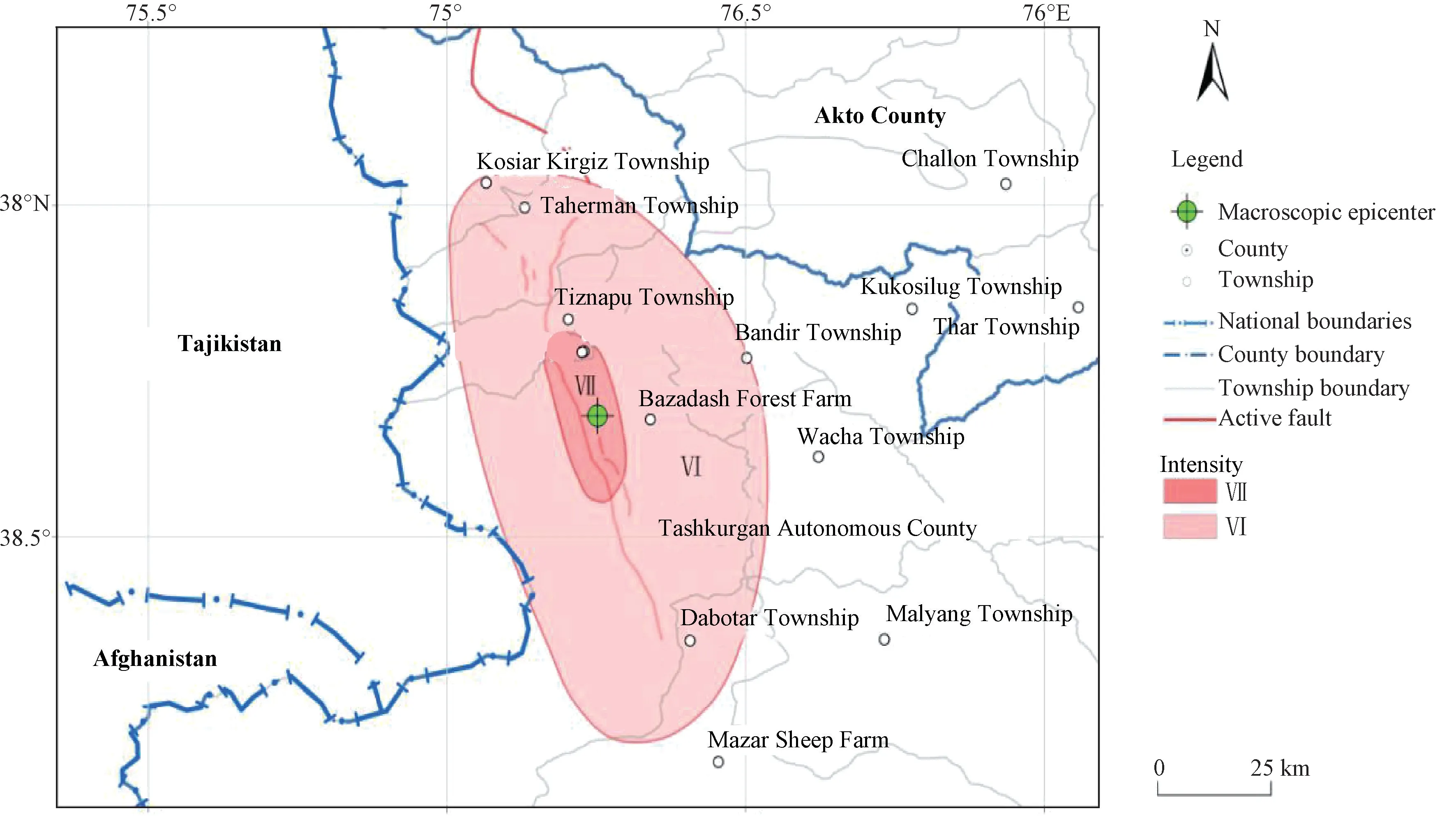
Figure 1 Intensity Map of the MS5.5 Earthquake in Tashkurgan County,Xinjiang
Tilt photography technology has become an advanced technique in the field of international surveying and mapping in recent years.It uses multiple sensors on the same flying platform to simultaneously acquire images from 5 different angles which include 1 vertical and 4 oblique lenses,exhibiting a real and intuitive world that matches human vision.The images obtained from oblique lenses not only reflect the real situation of the features,but also provide more detailed information and more advanced user experience with the adoption of advanced positioning technology embedded with accurate geographic information.This technology has been widely used in emergency command,homeland security,urban management,real estate tax and other industries in the developed countries in Europe and America.However,the domestic application is still immature.The main industries are land use,real estate tax,digital cities,environmental monitoring,and disaster assessments (Lu Heng et al.,2016a; Shuai Xianghua et al.,2018).The application content mainly includes the study of water and soil resources,urban 3-D modeling,monitoring of building spatial changes,flash flood disasters,and earthquake damage characteristics of buildings (Lu Heng et al.,2016b; Li Weiwei et al.,2016).In the TashkurganMS5.5 earthquake,the polar earthquake area is concentrated due to the relatively abundant earthquake damage and typical characteristics.In order to have an efficient rescue deployment and take advantage of the earthquake damage data of the Tashkurgan earthquake,this paper obtains tilt photopraphy data from about 0.52 km2in the TashkurganMS5.5 earthquake.The visual interpretation of different collapsed buildings is conducted using photographic data,and the collapse rate of the buildings is analyzed based on three-dimensional oblique photographic images.
1 DATA AND METHODS
1.1 Survey Area Overview
The UAV aerial survey is conducted in Kuzgung Village,Tashkurgan Township,Tashkurgan County and the survey spot locates in a flat zone to the west of Kashgar region.On the survey date,there is no wind,and the visibility of aerial flight is excellent.
1.2 Field data acquisition
The main parameters of the low altitude remote sensing UAV for emergency relief is as follows:payload is 3.5 kg,maximum flight speed is 20 m/s,maximum flight time is 18.5 min,working environment temperature is -10℃ to 40℃,automatic take-off,automatic return and landing.Additional specific parameters,advantages and disadvantages are shown in Table 2.The UAV plays an important role in understanding the damage degree and spatial distribution of buildings in the disaster area.It is efficient in earthquake emergency and provides first-hand information and scientific decision-making basis for rescue,disaster assessment and post-disaster reconstruction.
The UAV flight platform is equipped with a sensor which has a five-table array camera for the purpose of obtaining the ground feature information from five angles,including front view,rear view,left view,right view and down view.It simultaneously exposes and shoots five images in accordance with the fixed procedures every second.Each image has a ground resolution of 59 mm,a course overlap of 90% and a side overlap of 80%.Fixed-point exposure is used,and the aerial camera is Sony camera with a focal length of 35 mm.The specific parameters of UAV tilt photography data obtained are shown below:
The UAV of this flight has its own IMU/ DGPS system,which can automatically acquire and calculate the POS data corresponding to each image during the flight.Among them,IMU system is mainly composed of gyroscope,accelerometer,digital circuit,CPU and other parts,which are able to obtain UAV's speed,direction and other information.GPS system includes GPS receiver,which can complete UAV's position information calculation while searching GPS satellite signal.

Table 1 UAV image related parameters
1.2 3-D modeling
The altitude of the aerial photography area is approximately 3 300 m.According to the pre-flight settings,the overlap rate of the course and the side direction of the aerial photography are 80% and 60%,respectively.After the completion of the pre-designed route operation,aerial image collection,camera parameters,airborne POS data and other input parameters (Zang Ke et al.,2010),the professional UAV data processing software smart3D is used to carry out 3-D data modeling of the acquired image,forming a highly accurate 3-D image of the severe disaster area,and then conduct rapid remote sensing interpretation.The location and processing results of shadow UAV acquisition are shown in Fig.2 and Fig.3:
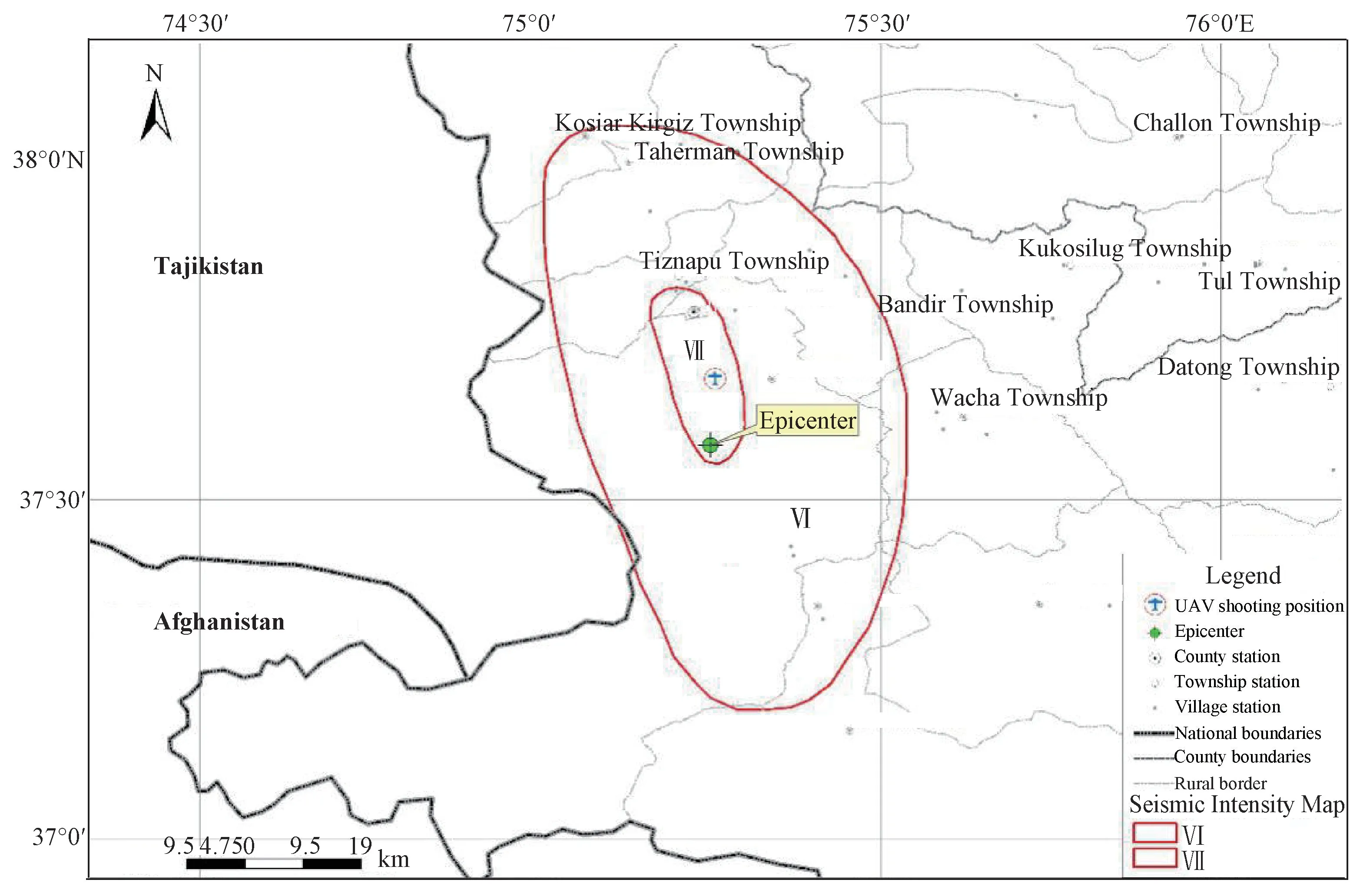
Figure 2 Location map of UAV image acquisition in the earthquake area in Tashkurgan
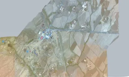
Figure 3 UAV image panorama of the Tashkurgan earthquake
The 3-D modeling process mainly includes data optimization preprocessing such as brightness and saturation of the original image,classification of vertical and oblique images,and POS provided by GPS/IMU according to camera parameters.The data determines the accurate exterior orientation elements and encrypts the triangles in the air.The multi-view images are closely matched to generate high-density point clouds and the 3-D irregular triangle network is constructed based on the point clouds to generate white models.The high-precision 3-D models are finally generated based on the automatic texture veneering technology (Shuai Xianghua et al.,2018).The modeling flow of tilt photography data is shown in Fig.4.
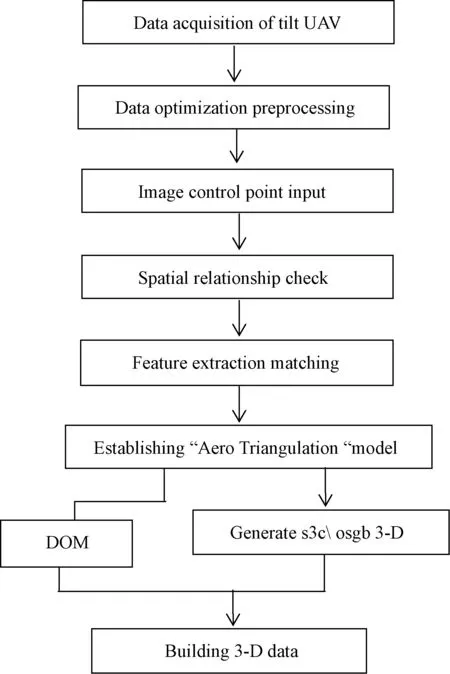
Figure 4 3-D modeling flow chart
For the data processing of UAV,engineering files are established at the initial stage,followed by the import of photos into five cameras.Then,“space three” relationship model is established for the final stage,in which a 3-D model is calculated and obtained in a s3c format.The “Aero Triangulation” result and s3c format 3-D model panorama in 3-D view are shown in Fig.5.
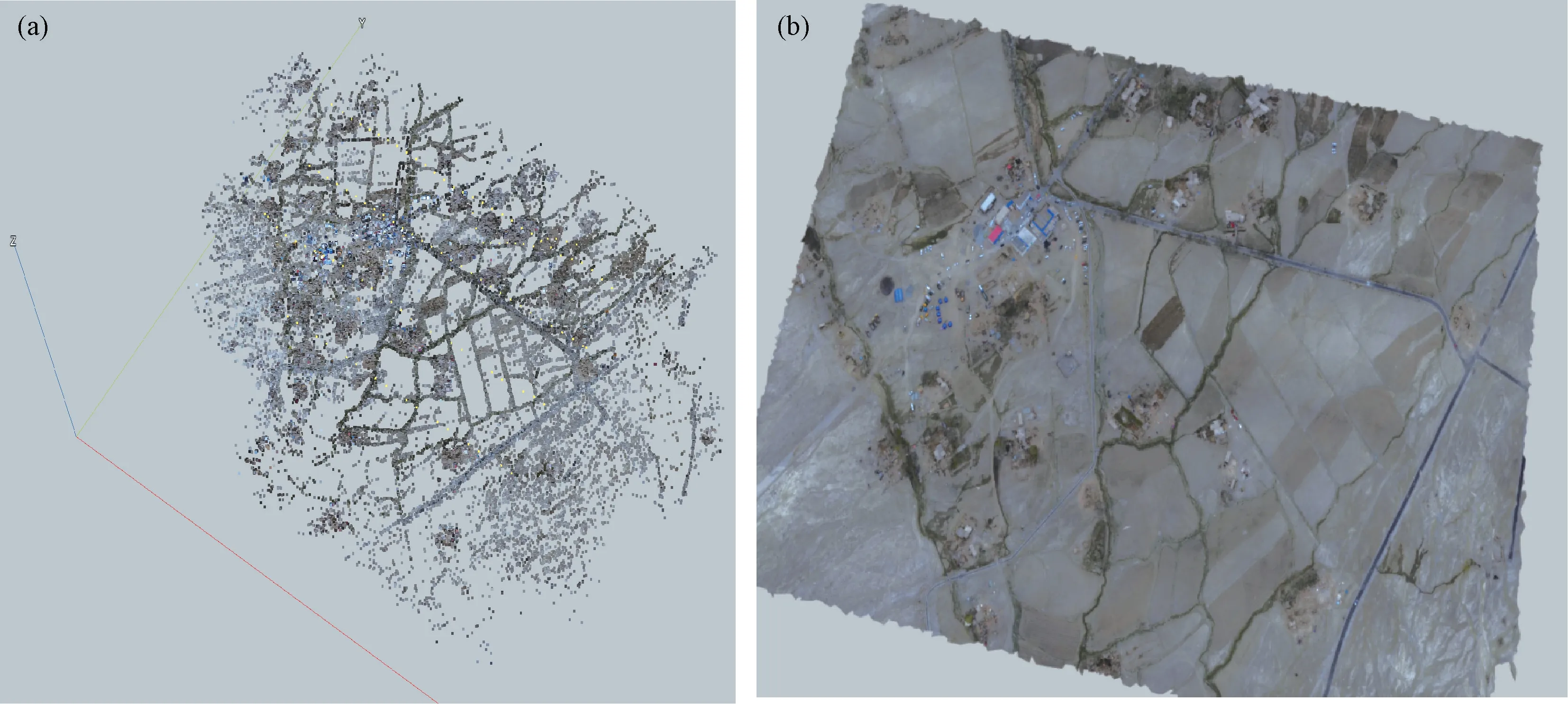
Figure 5 (a) Result chart of “Aero Triangulation”; (b) 3-D model panorama
2 EXPERIMENT
The goal of the experiment is to interpret the processed UAV tilt photography data in the Tashkurgan earthquake area.Using UAV data that are based on 3-D tilt photography,comprehensive and multi-angle interpretation regarding damage degree on these buildings can be obtained.(Wang Xiaoqing et al.,2015) Manual visual interpretation which includes the degree of damage to the houses in the severe disaster area is divided into different levels:‘destroyed’,‘severely damaged’,‘moderately damaged’,‘slightly damaged’,and‘basically preserved’ (including preserved).Because traditional orthophotos only obtain the roof data of the building,it is difficult to accurately identify these earthquake damage when the roof is not influenced,as shown in Fig.6(a).Orthophotos cannot be used to interpret house damage,although oblique images are able to reflect the buildings’ true appearance information.In such scenarios,the wall can be accurately identified even though the roof is not damaged.As shown in Fig.6(b),obvious cracks can be observed in the wall of the village committee of Kuzigun Village through the oblique image,but not the orthophoto.
In Xinjiang rural residential areas,typical structural buildings include earth rock timber structure,brick timber structure,brick concrete structure,frame structure and dwelling house,etc.Tilt image can better reflect the characteristics of different structural houses.Fig.7(a)-(d) show typical remote sensing interpretation images with different aforementioned damage degree on buildings in the aerial survey area.
Through the interpretation of UAV tilt photography data in the polar earthquake area,the types of building materials involved in the earthquake include earth-rock-wood,brick-wood,brick-concrete and frame houses.The collapsed houses are mainly earth-rock-wood buildings and civil-structure buildings.The collapse of earth-rock-wood buildings in the study area is about 83.2%.Some of the brick-wood buildings and brick-concrete buildings are seriously damaged,while the frame structure buildings are mainly slightly damaged.Public buildings Such as Schools,hospitals are mostly frame structures,and a few cracks have been generated in the walls during the earthquake.As shown in Fig.8,red circles indicate collapsed and severely damaged houses,purple circles indicate moderately damaged houses,blue circles indicate slightly damaged houses,and green circles indicate basically intact houses.
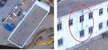
Figure 6 Comparison of house damage between orthophoto and oblique photography(a) Orthophoto; (b) Oblique photographic image
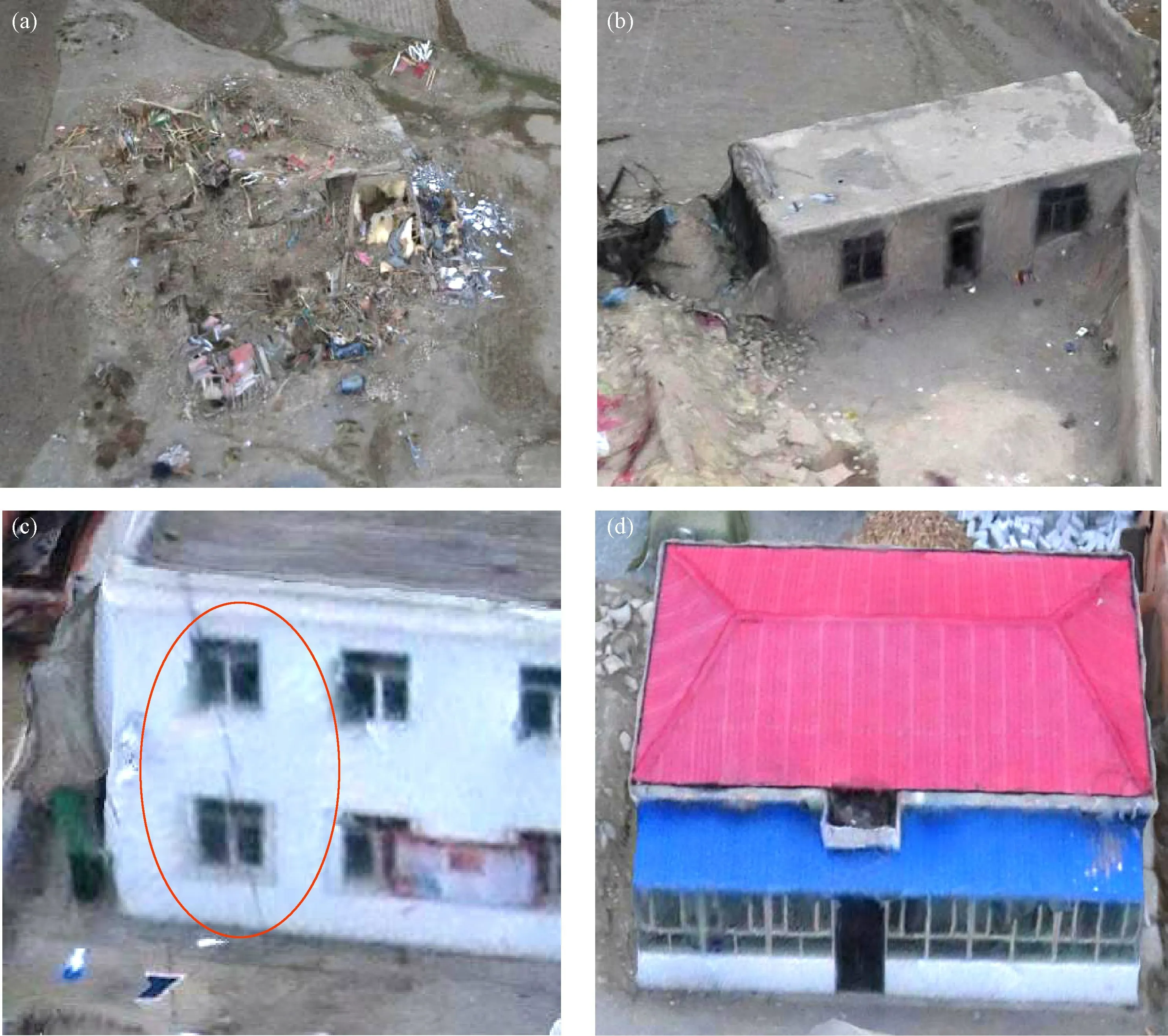
Figure 7 Damage chart of typical buildings in seismic area
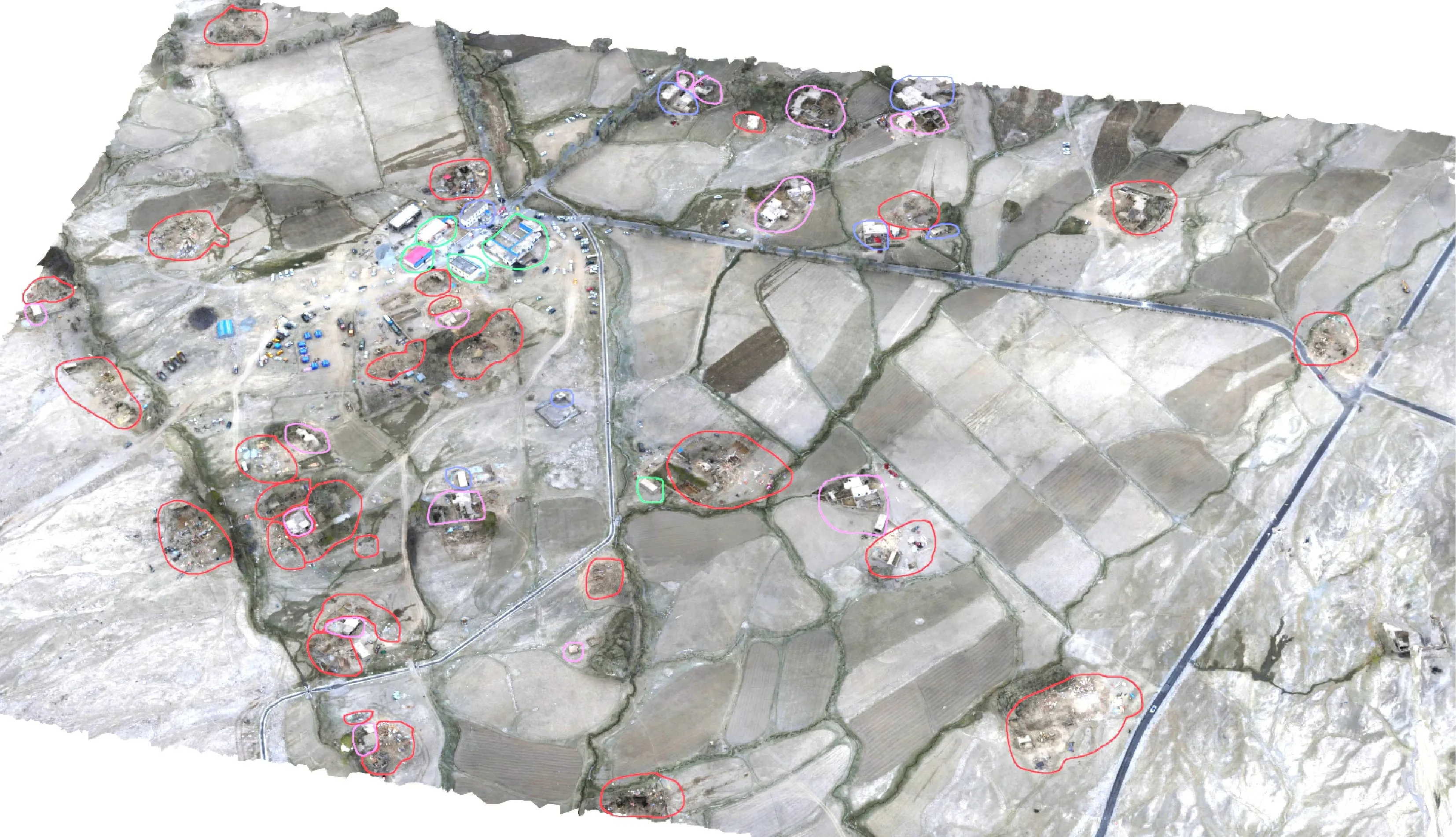
Figure 8 Interpretation results of the study area
On-site survey results show that brick and wood structure houses are newly-built in towns and villages,which have structural measures and the ability of earthquake resistance.Old brick-wood houses are not built for earthquake resistance,and are mostly made of silt and wooden roofs.Houses are generally tall with large open rooms and poor masonry quality,and there is no connection between vertical and horizontal walls.The severe damage to old brick-wood houses during the earthquake manifests as numerous shear cracks or flashovers on the load-bearing walls of the houses and the roof collapses in some regions.Moderate damage is mainly caused by oblique or vertical cracking of the wall,but the extension length is longer,extending from the top to the bottom.The severe disaster area has been damaged more than 24%,but no house has entirely collapsed.
According to the load-bearing walls,the earth-rock-wood structure houses can be divided into two categories,one of which is mainly distributed in the inclined plain area of Piedmont diluvial fan,mostly built by local residents.For the construction process of the roof structure,house beam is set up first,followed by laying short wooden strips on it as rafter.Then,the straw mat and house mud are laid on the rafter,successively.The roof mud of some old houses is thick,and the walls are made of pebble and silt,leading to the poor bond strength.The inferior construction materials,together with the impact of construction quality and site conditions,have caused large-scale damages.This is the main cause of casualties caused by the earthquake.The other category is mainly distributed on the terraces on both sides of the Tashkurgan River.Most of these houses are made of adobes.Due to the backward economy,inconvenient transportation and high construction cost,there are still a large number of earth-wood buildings in the county.Combined with the field investigation,the results show that most of the first kind of houses entirely collapsed,while the second kind of houses partly collapsed with a relatively small number.Neither of these two houses have the ability of earthquake-resistence.Brick and concrete structure houses are mainly public houses constructed in townships (towns),and most of the county houses are residential houses.After 2010,brick and concrete buildings are constructed with earthquakeresistant requirements,resulting in only several cracks on walls after the earthquake.By comparison,the buildings constructed before 2000 have low shockproof ability and thus have led to serious destruction.Besides,most of the frame structures are new office buildings built after 2010 and have good earthquake-resistance ability,causing no structural damage,even though large works are still needed to repair the cracks in infilled walls.The wealthy houses remain well-preserved.Combined with the field survey results,it is shown that the interpretation results of the UAV provided by tilt photography have higher accuracy and reliability.Especially,different destruction situations after earthquakes can be analyzed from different angle.Comparing the tilt photography technology with the traditional vertical photography,it is obvious that the former one is of high practical value in extracting features of exterior walls and cracks.
3 CONCLUSION
The oblique photography technology has become an advanced technique in the field of international surveying and mapping in recent years.It is used in earthquake emergency and earthquake disaster acquisition to break the boundary that previous orthophotos can only be taken from a vertical angle.The platform is equipped with multiple sensors and collects images of buildings after the earthquake from one vertical and multiple tilt angles at the same time,which is in line with the real and intuitive effects of human vision,and provides first-hand information for earthquake emergency rescue deployment,disaster investigation and judgment in disaster areas.In this study,the use of tilt photography in the exploration of the TashkurganMS5.5 earthquake in Xinjiang has reached the following conclusions:
(1)Based on tilt photography,this study deciphers the epicentral area of theMS5.5 Tashkurgan earthquake by artificially visual interpretation,and analyzes the different damage levels of buildings from different perspectives after the earthquake.Compared with the traditional Orthophoto Image,this study further extracts the exterior walls and the cracks of the buildings,enhancing the practicability and reliability in the post-earthquake disaster extraction.
(2) UAV technology improves the ability of post-earthquake information collection of the disaster area.The most important data for the rescue work is the first-hand survey data of the disaster area.Furthermore,efficient rescue deployment depends on the technical support provided by a series of investigations,including timely survey of the damage degree on buildings,scope of influence,casualty and property loss,traffic conditions,and potential secondary disasters.However,due to the possible secondary disaster damage during the postearthquake investigations,combined with the limitation of accessibility in the disaster area,regular investigations are lack of speed and accuracy,further restricting the high requirement of time efficiency for the earthquake disaster rescue.
(3) UAV remote sensing image improves the efficiency of disaster information interpretation.Tilt camera UAV has low requirements on takeoff and landing conditions,and can immediately generate Orthophoto Images in seismic areas.Meanwhile,the UAV technology permits real-time transmission of high-resolution videos,and captures the details of the scene in the first time.All the aforementioned advantages are able to provide technical support for on-site rescue,disaster assessment and earthquake disaster investigation,ensuring that the emergency work can be conducted efficiently.As a result,correct analysis and assessment can be obtained,leading to more scientific,rational strategies of emergency rescue.
(4) Based on the images provided by tilt camera UAV,the structural types of buildings and the destruction situations of buildings in the polar earthquake area are interpreted.In detail,the structural types of buildings in the aerial survey area mainly include frame structure,brick concrete structure,brick wood structure and earth rock wood structure.The collapsed and partially collapsed houses are all made of earth rock and wood structures.The collapse rate of earth rock and wood structure houses in the aerial survey area is 83.2%.The frame structure houses are mainly slightly damaged.A few brick wood houses and brick concrete houses are seriously damaged,and the wealthy houses are almost preserved.The UAV technology which is based on tilt photography has been preliminarily explored and applied in building destruction as well as disaster situation extraction.Meanwhile,it shows broader application prospect in rapid extraction of building structure,intelligent recognition of different levels of damage,and related research.
 Earthquake Research Advances2020年2期
- Earthquake Research Advances的其它文章
- Influence of Bedding and Mineral Composition on Mechanical Properties and Its Implication for Hydraulic Fracturing of Shale Oil Reservoirs1
- Progress and Prospect of Geophysical Research on Underground Gas Storage:A Case Study of Hutubi Gas Storage,Xinjiang,China1
- Analysis of Anomalous Characteristics of Regional Crustal Deformation before the September 16th,2019 Zhangye MS5.0 Earthquake,Gansu,China1
- Study of the Seismogenic Structure of the October 12th,2019 MS 5.2 Beiliu Earthquake,Guangxi,China1
- Analysis of Power Supply Interference of Geomagnetic Second Data Observation-Take Changli Seismic Station as An Example1
- New Understanding of Variation Characteristics of Well Water Level in Majiagou Mine,Tangshan City,Hebei,China1
