Study of the Seismogenic Structure of the October 12th,2019 MS 5.2 Beiliu Earthquake,Guangxi,China1
BI Lisi,LU Banghua,YANG Xuan and WU Bin
Key Laboratory of Earthquake Monitoring and Disaster Mitigation Technology,Guangdong Earthquake Agency,Guangzhou 510070,China
On October 12th,2019,a MS5.2 earthquake occurred in Beiliu City,Guangxi Zhuang Autonomous Region,China,with a focal depth of 10 km.The epicenter is located in the junction of Guangxi and Guangdong where the moderate-strong earthquakes are relatively active.The highest intensity of this earthquake is estimated up to Ⅵbesides the isoseismic line showed an ellipse shape with a long axis trend in the NW direction.The aftershocks are not evenly distributed.The parameters of the focal mechanism solutions are:strike 346°,dip 85°,rake 19° for the nodal planeⅠ,and strike 254°,dip 71°,rake 175° for the nodal planeⅡ.The type of the coseismic fault is strike-slip.After analyzing these results above and the active faults near the epicenter,we get that the nodal planeⅠis interpreted as the coseismic rupture plane and the Bama-Bobai Fault is a seismogenic structure of MS5.2 Beiliu earthquake.
Key words:MS5.2 Beiliu earthquake; Seismogenic structure; Border area between Guangdong and Guangxi; Bama-Bobai Fault
INTRODUCTION
According to China Earthquake Networks Center (CENC),aMS5.2 earthquake occurred in Beiliu City of Guangxi Zhuang Autonomous Region,China (22.18° N,110.51°E) at 22 ∶55 on October 12th,2019.The earthquake has a focal depth of 10 km,with the epicenter locates in Liujing Town,Beiliu City in the junction of Guangxi and Guangdong Province.Strong tremors are felt in Nanning,Wuzhou,Yulin,Fangcheng,Guigang and Qinzhou in Guangxi,and in Zhanjiang,Maoming,Foshan,Yunfu and Jiangmen in Guangdong Province.The earthquake causes damage to a total of five villages and towns in Guangxi and Guangdong.This is anotherMS≥5.0 earthquake following theMS5.4 Cangwu earthquake which broke the record that noMS≥5.0 earthquakes had occurred in the coastal seismic zone in South China in the past 17 years(Mo Peichan et al.,2018a,b).It is also one of the most intensive and influential earthquakes in Guangxi in recent years.Therefore,identifying the seismogenic structure and characteristics of the earthquake is of great significance for studying the conditions and mechanisms of strong earthquakes in the junction of Guangdong and Guangxi,analyzing the subsequent trends in regional earthquakes,and strengthening prevention of earthquake risks in areas with few and weak earthquakes.
1 REGIONAL GEOLOGICAL STRUCTURE
TheMS5.2 Beiliu earthquake occurred in the differential uplift area of the South China Fold System between the western Guangdong and southeastern Guangxi,and in the uplift area of the Yunkai Mountains fault-block from the perspective of neotectonics (Fig.1).The area has experienced multi-phase tectonic evolution,mainly with differential uplifts in the new tectonic phase.The northern and central parts of the area have been lifted intermittently in neotectonic movements,causing the Cretaceous oceanic red bedrocks to be eroded and forming gently undulating multi-level low hills and platforms.Vertical differential movements have been found in the southern coastal area,even though the range of movements is small.Some areas (for example,Maoming Basin) under the influence of the active NW faults are relatively intense vertical differential movements.The NE and NW faults intersect in the area,forming an “X”-shaped structural framework,with rift basins developed,strata well developed,and granite widely distributed (You Xiangzhao,1988;Li Weiqi,1989; Zhang Jiyan,2002).
Negative Bouguer anomalies are identified in most parts of the epicenter.These parts is the highest in the region.Aeromagnetic anomalies in the region mainly show as positive and negative isopleths,which alternate in a planar distribution.The anomalies mainly trend near EW,and their values are relatively large.The thickness of the crust in the region ranges between 28 and 32 km and the isopaches are generally in NW direction.The epicenter is located in the uplift area of Moho Discontinuity,as well as the area where the iso-lines of vertical crustal deformation rates in the southeastern Guangxi and western Guangdong turn from NEE to NW.The complex structural location may be an important factor in the formation of seismotectonic structures (Ren Zhenhuan et al.,2016).
The epicenter of theMS5.2 Beiliu earthquake is located in the junction of Guangdong and Guangxi in the western section of the South China coastal seismic belt.This area,the intersection of the NEE South Ridges seismic belt and the NW Red River system seismic belt (Bama-Zhanjiang) (Ren Zhenhuan,1999),has witness relatively frequent major earthquakes fromMS5.0 toMS6.0 (Mo Jingye et al.,1990; Guo Peilan,2005; Zheng Ping et al.,2018).19 earthquakes withMS≥5.0 occurred within 150 km from the epicenter.The most severe one is theearthquake occurred in Lingshan on April 1st,1936,and the nearest one is theearthquake in southeastern Yulin (Beiliu) on October 29th,1778,about 37 km north of the epicenter.Small and medium earthquakes are concentrated in the seismic belt of Red River system and distributed in a NW direction (Fig.1).
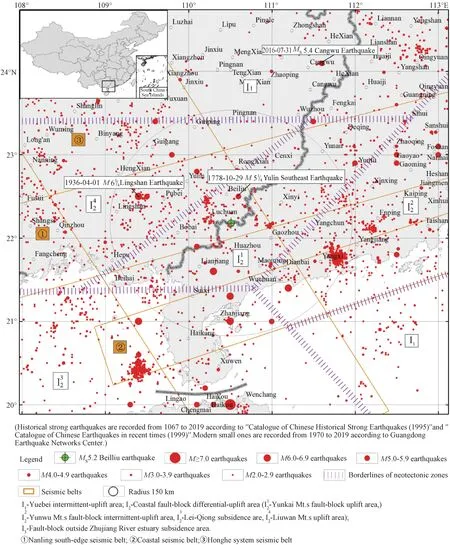
Figure 1 Map of seismology background in the junction of Guangdong,Guangxi and Hainan
2 FAULTS IN THE EPICENTER REGION AND THERE ACTIVITIES
The shallow crustal structures within 100 km from the epicenter are mainly faults,which are classified into three groups by strike:NE,NW,and near EW (Fig.2).Among them,the NE-trending faults are most developed.They are huge in scale and long in extension,represented by Xinyi-Lianjiang Fault and Hepu-Beiliu Fault.The NW-trending faults are small in scale and poor in continuity.Though newly developed,they are with most of the Cenozoic sedimentary and seismic activities.Among them,Bama-Bobai Fault and Maoming Basin North-edge Fault are of larger scale.The NE and NW faults intersect in the region,forming an “X”-shaped grid of crustal ruptures.The near EW-trending faults,basically located in Beibuwan Basin and Lei-Qiong Peninsula,are relatively small in scale and are active to varied extents during the neotectonic period,such as Suixi Fault.
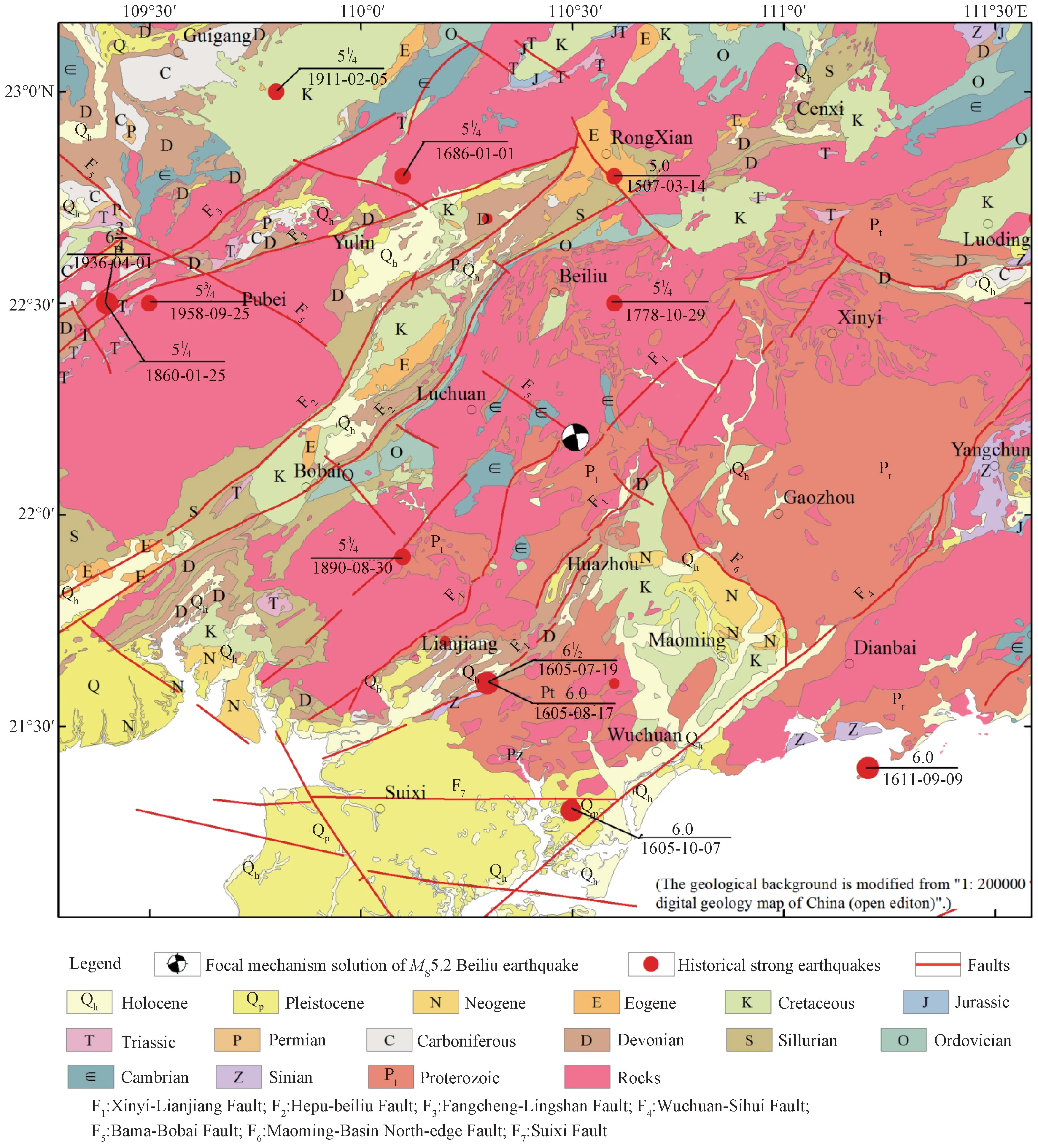
Figure 2 Distribution of main faults in the epicenter region
2.1 Xinyi-Lianjiang Fault
The 150 km Xinyi-Lianjiang Fault,in general from NE to NEE.Formed in the Caledonian Period with major geological activities in history,it is a fault with relatively frequent seismic activities in western Guangdong.The fault,consisting of east and west branches,is roughly divided into NE and SW sections by Nashui Basin.The NE section is mainly composed of Caledonian migmatite and granite,and shows a normal fault dipping to NW.With some activities observed since the Quaternary Period,it intersects with the NW faults,but is not obviously indicated by linear satellite images.The SW section striking from NE to NEE constitutes the boundary between the Cambrian and Devonian systems.It has obvious Cenozoic activities and controlled the development of geomorphology in the Quaternary Period.The orientation of small basins,low mountain ridges and valleys,are developed along the fault and the direction of the distribution of hot springs are basically the same as the orientation of the faults.Their band images on satellite maps are also clear and straight (Guangxi Bureau of Geology and Mineral Resource,1985; Guangdong Bureau of Geology and Mineral Resource,1988; Wei Bolin,2001).The SEM analysis results of quartz grains in the fault mud indicate obvious activities in the Pliocene and early Pleistocene.Fresh fault mud is found in the profile of artificial excavation near Shajing in the SW of Lianjiang City,indicating an electron spin resonance(ESR) dating of(348±49)ka.Right-lateral near-horizontal scratches clearly developed on the fault surface show that the latest activities of the fault is right-lateral strike-slip.According to the survey of boreholes and profiles in Hengshan Town,the SW section of the fault is hidden beneath Jiuzhou River alluvial plain,and the lower part of the Quaternary Period is obviously faulted,indicating the latest activities may happened between the late Early Pleistocene to Middle Pleistocene (Zhang Longsheng et al.,2016).
2.2 Hepu-Beiliu Fault
The Hepu-Beiliu Fault is a giant NE-NEE belt,which runs through the southeastern Guangxi as an important boundary between the new tectonic zones.It starts in the NW from the Beibu Gulf waters,running NE direction through Hepu,Luchuan,Beiliu,Rongxian all the way to Guangdong and Hunan Province,with a total length of about 450 km (Guangxi Bureau of Geology and Mineral Resource,1985; Huang Yukun et al.,1992).The epicenter area of the earthquake mainly includes the SW section in Rongxian,which is divided into east and west branches.The west branch of the fault is in 40-50° strike with 70° NW dip.Several fault depression basins such as Hepu,Bobai,Yulin and Rongxian are formed along the fault in the Mesozoic and Cenozoic eras.Tectonic landforms such as fault scarps,steep ridges and valleys are developed on the fault.Significant topographical differences are noted between both sides of the fault,with clear linear features shown on the satellite images (Huang Yukun et al.,1992).The east branch of the fault shows an “S”-shaped curve in planar geometry.With 30°-40° strike and 40°-70° SE dip,the east branch has less distinctive topographical appearance than the west one.The two branches constitute a thrust fault in the early stage.The thrust fault gradually evolves into a strike-slip normal fault due to the changes to the occurrence and properties of some sections caused multiple activities in the later stage.The field profile shows that the west branch has faulted the layers in the Neogene and Early Pleistocene,residual layers in the Late Pleistocene above the fault have not been disturbed,and fresh right-lateral horizontal scratches have been found on the fault surface.According to the survey of boreholes and profiles in Hepu Basin section,the last activity in this section should have occurred in the middle and late period of the early Pleistocene (Wang Mingming et al.,2009).The east branch is active in early age,indicating activities at the end of the Neogene and there is basically no activity since the Quaternary Period (Wang Yipeng et al.,1996).The fault zone shows obvious NE linear features on the map of Bouguer anomalies,and displays NE beaded bands,namely zone of positive and negative anomalies,on the map of aeromagnetic anomalies (Guo Peilan,2005).Small earthquakeevents in zonal distribution are found to occur along this fault.
2.3 Bama-Bobai Fault
The SE-end of the Bama-Bobai Fault Zone may start in Wuchuan and Dianbai of Guangdong Province,in the NW direction through Gucheng,Bobai,Hengxian and Binyang to the west of Bama of Guangxi.This 800-km giant NW fault traverses Guangxi as part of the Red River system.The fault zone consists of several intermittently extending faults in 20°-50° NW strike and 40°-85°NE dip.It has witness left-lateral strike-slip since the new tectonic phase and has obvious activities in the middle of Middle Pleistocene (Hou Jianjun et al.,1993).The fault zone have developed Paleogene and Quaternary basins,as well as fault troughs,fault scarps and triangular facets.The fault breaks the tectonic lines and geomorphic units of other strikes and remains highly active.In the areas of Kunlun Pass and Lu Village,the left-lateral fault planes stagger from the Yanshanian granite and the Paleogene system by 4 000 m,while the Cambrian System is noted to thrust over the Paleogene system.The fault is highlighted in both the maps of gravity anomalies and aeromagnetic anomalies.Measurements of gravity flows in the 1990s indicate that there is a giant NW gradient zone along the fault,and the gas measurements of the fault also show high-value anomalies(Ren Zhenghuan,1999).This fault has causedandMS6.0 earthquakes and multipleMS5.0 ones at its intersections with NE Fangcheng-Lingshan Fault and with Xinyi-Lianjiang Fault,hence is a major active fault which may cause powerful earthquakes (Li Weiqi,1992;Li Xiguang et al.,2017,2018).In fact,the epicenter of the Beiliu earthquake fall right at the intersection of the NW Bama-Bobai Fault and the NE Xinyi-Lianjiang Fault.
2.4 The Maoming Basin North-edge Fault
The Maoming Basin north-edge fault forms the northern boundary of the Maoming Paleogene-Neogene Basin,extending from NW to SW.It is a 62-km normal fault in 50-70°SW dip.Exposed mylonites,broken breccias,siliceous rocks and quartz veins are observed along the fault.The landforms include fault scarps and triangular facets,etc.The height difference between the two fault planes ranges from over 10 m to nearly 100 m.During the Paleogene and Neogene periods,Maoming Basin on the SW fault plane has significant vertical differential movements relative to the bedrock on the northeast plane.Thick lacustrine strata are accumulated in the basin,the sedimentary center is the NW edge of the basin near the fault,and the bedrock is denuded.However,since the Quaternary Period,the differential activities between the basin and the mountain are reduced and stopped.Meanwhile,the basin and the mountain are raised,and the basin surface become rough due to many small bumps formed by alluvial gravel layers in the Neogene System or Quaternary Period.The residual layers in the Late Pleistocene covering the fault plane have not been disturbed.The fault mud collected in Helingzi area is more than 1.5 million years old,indicating that the latest activity of the fault may occurres in the early Middle Pleistocene.
3 FOCAL MECHANISM SOLUTIONS
A focal mechanism solution (FMS) is able to reflect the geometric and kinematic characteristics of the surface rupture caused by an earthquake.An accurate FMS is of great significance for determining the cause,seismogenic structure,dynamic environment of earthquakes,and for estimating the trend and the danger of aftershocks(Zheng Yong et al.,2009; Yi Guixi et al.,2017).After the Beiliu earthquake,Guangdong Earthquake Networks Center (GENC) provides the FMS of the earthquake immediately .
As a doublet earthquake,the Beiliu earthquake have aMS4.6 foreshock and aMS5.2 main shock.The basic parameters of the two shocks are shown in Table 1.As the two shocks overlaps,it is quite challenging to provide an FMS for the second one.GENC first analyzed the FMS for the first shock,then compare the preliminary study results of several nearby stations,and come to the preliminary conclusion that the FMSs for the two shocks are the same,which are shown as follows:strike 346°,dip 85°,rake 19° for the Nodal Plane I,and strike 254°,dip 71°,rake 175° for the Nodal Plane II,while the type of the coseismic fault is strike-slip.

Table 1 Source parameters of the ML4.6 and ML5.3 Beiliu earthquakes
4 DISTRIBUTION OF AFTERSHOCKS
The spatial distribution of an aftershock sequence largely reflects the rupture range of an earthquake,and serves as an important basis and fundamental data for determining the seismogenic structure(Zhang Peizhen et al.,2009;Yi Guixi et al.,2017;Weng Zhaoqiang et al.,2018).The earthquake occurred in a well-monitored area where 10 seismic stations are located within 100 km of the epicenter and 32 stations within 200 km to position the earthquake to a satisfactory level (Hu Wenzhuo et al.,2019).After the earthquake,Earthquake Agency of Guangxi Zhuang Autonomous Region and its counterpart in Guangdong quickly set up six mobile seismic stations around the epicenter to further enhance seismic monitoring level of the epicenter area toML0.1.
The aftershock sequence in this article is a repositioning directory (absolute positioning) obtained using HYPOSAT,which is reliable enough to analyze the characteristics of spatial distribution of aftershocks.After the main shock,GENC records a total of 171 aftershocks as of October 31st,2019,including 1 shock withML3.2,3 withML2.0-2.9,38 withML1.0-1.9 and 129≤ML1.0.Among them,the greatest aftershock isML3.2 occurring at 23 ∶31 on October 12th,2019 is (Fig.3).The focal depths ranged between 5-15 km,of which about 70% is between 5-8 km (Fig.3 (b)).The characteristics of the earthquake sequence indicate that the earthquake has a mainshockaftershock sequence,and that the aftershocks appeare attenuating.The aftershocks are not unevenly distributed on the plane,mostly concentrated on the SW end of the northeast section of Xinyi-Lianjiang Fault in Guangdong,and are scattered in other places.While no dominant direction is noted,the sequence is shown vaguely as an ellipse shape with a long axis trending in NW direction,and the long and short axes are about 27 km and 23 km long,respectively(Fig.3(a)).
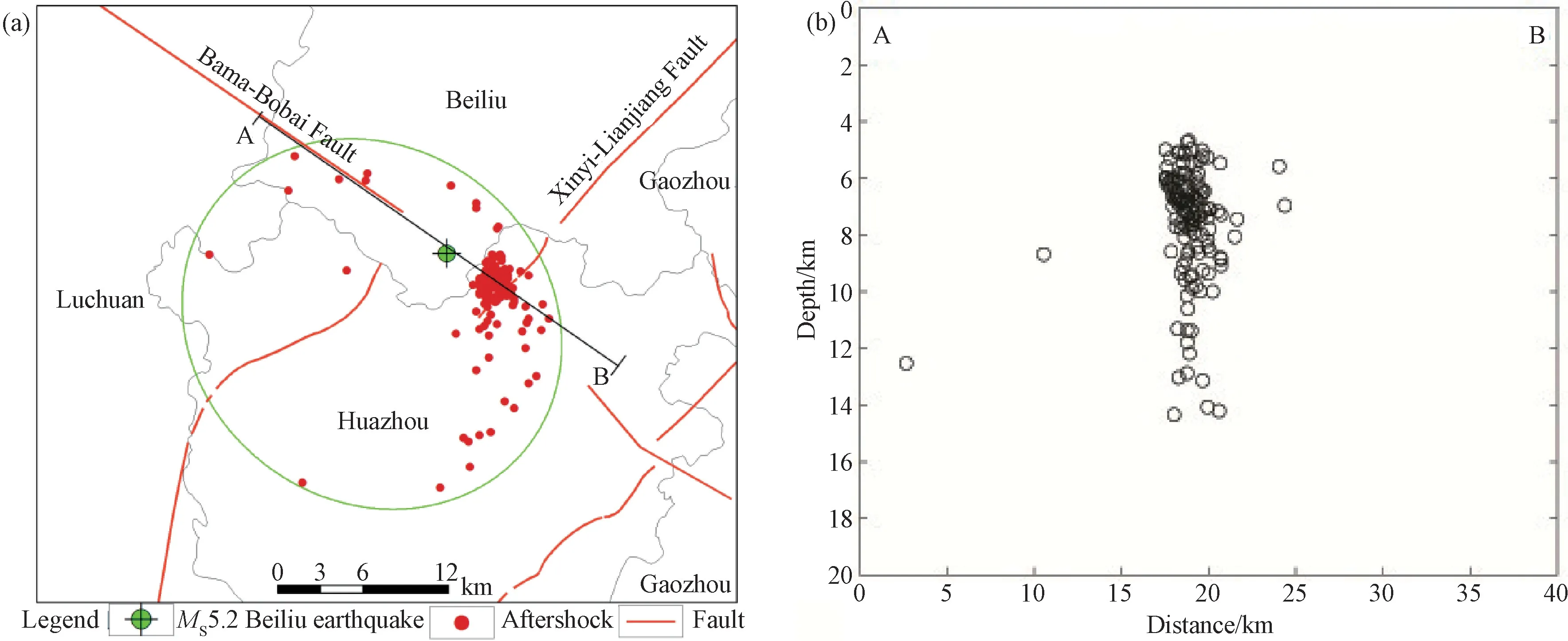
Figure 3 Distribution map of Beiliu earthquake sequence
5 MACROSEISMIC SCALE OF THE EARTHQUAKE
The macroseismic scale,as reflected by the seismic and geological data from field surveys,is the direct basis for identifying the seismogenic structure.Right after the Beiliu Earthquake,the Earthquake Agencies of Guangxi and Guangdong assign a team to conduct disaster investigation and evaluation of earthquake intensity at site.On October 14th,2019,upon the approval of China Earthquake Administration,the Guangxi and Guangdong Earthquake Agency jointly released the intensity map of the earthquake (Fig.4).
The Beiliu earthquake is recorded an intensity of VI in the meizoseismal area,with the macro epicenter located at Liujing Town,Beiliu City,Guangxi Zhuang Autonomous Region.The isoseismic lines are shown as an ellipse,where the long axis trending in NWdirection is 19 km long and the short one is 10 km,covering 141 km2and causing damages to 5 towns in Guangxi and Guangdong,namely Liujing Town,Shiwo Town and Qingwan Town in Liubei City,Guangxi,and Pingding Town and Boyang Town in Huazhou City,Guangdong.The damage of the earthquake was mainly found with the local houses.Several misplacement of the roof slabs and walls,together cracks in staircase walls.A small number of houses suffered from widened or stretched existing cracks,dropping of small patches of wall plastering,and some shaken or dropping of roof eaves.The direction of coseismic movements is mainly NW-SE.No geological disasters such as ground rupture,soil liquefaction,and soft-soil subsidence are found at the site of the earthquake.And the outcrops of fault branches like Bama-Bobai Fault and Xinyi-Lianjiang Fault are observed within the epicentral area.
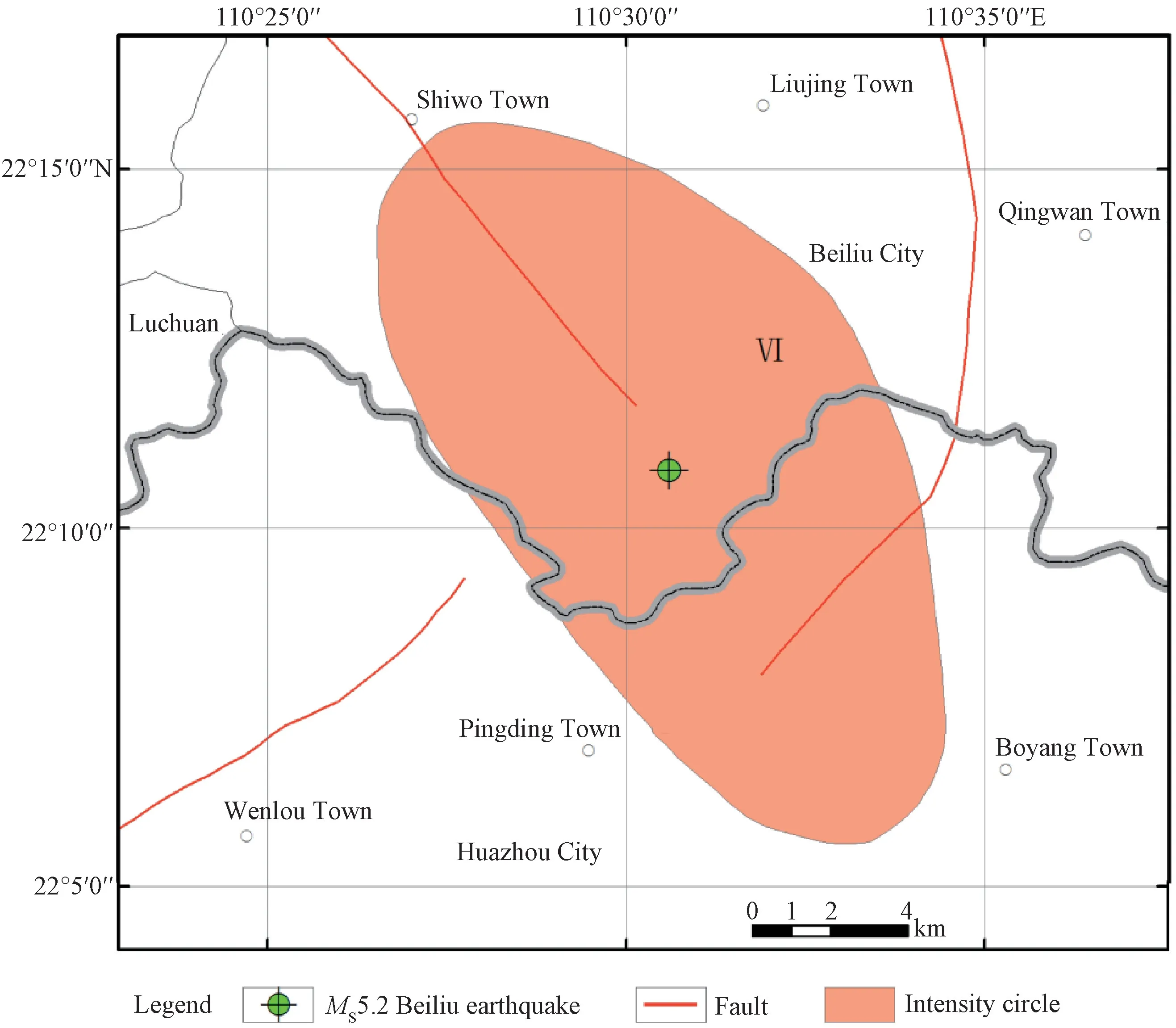
Figure 4 Intensity map of the MS5.2 Beiliu earthquake
6 ANALYSIS OF SEISMOGENIC STRUCTURE
Nowadays the seismogenic structure of moderate and strong earthquakes is determined mainly based on FMS,distribution of isoseismic lines,distribution of aftershocks and seismic geological field surveys(Zhong Yijun et al.,2003).Among the known faults in the areas near the epicenter of the Beiliu Earthquake,the NW Bama-Bobai Fault and the NE Xinyi-Lianjiang Fault are most closely related to the earthquake.From the perspective of the macroseismic scale,the isoseismic lines are shown as an ellipse with a long axis trending in NW direction.The axis coincides with Bama-Bobai Fault,and the epicenter is also located on the fault.Various earthquakes at home and abroad show that the long axes of isoseismic lines,especially in meizoseismal area,mostly coincide with the coseismic faults in terms of the orientation and spatial location (Zhong Yijun et al.,2003).Therefore,the distribution of the isoseismic lines indicates that the seismogenic structure of the Beiliu earthquake should be Bama-Bobai Fault.In addition,the directions of the main axes of aftershocks are generally those of the seismogenic structures,and the axes often coincide with the seismogenic structures (Ren Zhenhuan et al.,1996).From the perspective of the spatial distribution of aftershocks,a vague NW is observed.This,to some extent,also indicates that the fault ruptures and releases energy along the NW direction.Moreover,the aftershocks concentrate on the SE end of the main shock.In terms of seismogenic structures,this is the SW end of the northeast section of Xinyi-Lianjiang Fault.Therefore,it is speculated that after the main shock,the energy is released in the weak part of the intersection of the NW Bama-Bobai Fault and the NE Xinyi-Lianjiang Fault.According to the FMS,Nodal Plane I has a NW-SE strike,NE85° dip and is left-lateral strike-slip.This surface rupture is highly consistent with the occurrence and motion characteristics of Bama-Bobai Fault distributed along the long-axis of the meizoseismal area.Nodal Plane II has a NEE-SWW strike,NW71° dip and right-lateral strike-slip.This coincides with the strike of Pubei-Xinyi Fault described by Ren Zhenhuan et al.(2016) based on gravity data.However,this fault is not reflected in many maps or data,and the distribution of aftershocks and isoseismic lines do not show such NEE distribution feature.Therefore,the NWW surface rupture indicates that Bama-Bobai Fault should be the seismogenic structure of theMS5.2 earthquake in Beiliu,Guangxi,with the strike of 354°,NE71° dip and the left-lateral strike-slip feature.Bama-Bobai Fault has once conjugated with Fangcheng-Lingshan Fault,causing theearthquake in Lingshan in 1936 and manyMS5.0 earthquakes.It also plays an active role in earthquake formation.
TheMS5.2 Beiliu earthquake confirms that the South China coastal seismic belt has now been in the fifth active episode after the occurrences of theMS5.4 earthquake in Cangwu,Guangxi on July 31st,2016 and theMS6.2 earthquake in Taiwan Strait on November 26th,2018.During the active episode,there is a high possibility thatMS≥5.0 earthquakes occur again at an obviously higher frequency in the junction of Guangdong,Guangxi and Hainan,posing increasingly challenging seismic situation.In view of the quite active fault structure in the junction of Guangdong,Guangxi and Hainan,the intersections of NW,NEE and NE faults provide structural environment forMS≥5.0 earthquake.Moreover,these fault structures gradually entering the phase of stress release are conducive to moderate and strong earthquakes,increasing the risks of earthquake occurrences in the area in the future.
7 CONCLUSION
AMS5.2 earthquake occures at Beiliu,Guangxi (22.18°N,110.51°E) at 22 ∶55 on October 12th,2019,with a focal depth of 10 km.The epicenter area of the earthquake is located in the uplift area of the Yunkai Mountains fault-block.Bouguer anomalies in the area are mostly negative and aeromagnetic anomalies positive.The area,mainly developes with NE,NEE,NW and EW faults,falls at the intersection of Guangdong and Guangxi where moderate and strong earthquakes often occur.
The research results show that the Beiliu earthquake have an intensity of VI in the meizoseismal area,and the isoseismic lines are shown as ellipse with long-axis trending in NW direction.The aftershocks are unevenly distributed on the plane and show no dominant direction,while the sequence is shown vaguely as an ellipse with a long axis trending in NW direction.The FMS parameters are:strike 346°,dip 85° and rake 19°for the Nodal Plane I,and strike 254°,dip 71° and rake 175° for the Nodal Plane II,and the type of the coseismic fault is strike-slip.Based on the comprehensive analysis of the above results and the conditions of faults near the epicenter,it is concluded that the NE Nodal Plane I is the coseismic plane and Bama-Bobai Fault is the coseismic fault in the Beiliu earthquake.The Beiliu earthquake serves as another proof that confirms the South China coastal seismic belt has now been in the fifth active episode,and there are high risks of earthquakes occurring in the junction of Guangdong,Guangxi and Hainan in the future.
 Earthquake Research Advances2020年2期
- Earthquake Research Advances的其它文章
- Influence of Bedding and Mineral Composition on Mechanical Properties and Its Implication for Hydraulic Fracturing of Shale Oil Reservoirs1
- Progress and Prospect of Geophysical Research on Underground Gas Storage:A Case Study of Hutubi Gas Storage,Xinjiang,China1
- Analysis of Anomalous Characteristics of Regional Crustal Deformation before the September 16th,2019 Zhangye MS5.0 Earthquake,Gansu,China1
- Analysis of Power Supply Interference of Geomagnetic Second Data Observation-Take Changli Seismic Station as An Example1
- New Understanding of Variation Characteristics of Well Water Level in Majiagou Mine,Tangshan City,Hebei,China1
- Microseism Variations in Response to Antarctic Seasonal Changes in Sea Ice Extent1
