New Understanding of Variation Characteristics of Well Water Level in Majiagou Mine,Tangshan City,Hebei,China1
ZHANG Suxin,SHENG Yanrui,DING Zhihua and ZHANG Ziguang
Hebei Earthquake Agency,Shijiazhuang 050021,China
Based on the well water level data in Majiagou Mine in Tangshan City since 2000,it is suggested that the water level rise from 2008-2014 is possibly associated with reduced infiltration caused by less precipitation,together with the effect of less groundwater exploitation.However,the water level rise from 1992-1998 cannot be interpreted properly if we extend the data source back to 1991.After comparing the data with long-term water level data of five wells with different hydro-geological units in Tangshan and Qinhuangdao,the study indicates that the long-term water level variation cannot be only attributed to the effect of less precipitation and the control of groundwater exploitation,but also with the influence of regional stress field change.With the support of regional geological and tectonic information,combined with the comprehensive analysis of CBM data obtained from the coal field,new understandings of the dynamic characteristics of annual variation are obtained.
Key words:Majiagou Well; Water level; Variation characteristics; Stress field
INTRODUCTION
Majiagou Mine,located in Tangshan,Hebei Province,is one of the most earthquakereflective observation wells which monitors the underground fluid level in North China.The mine is located in the Majiagou coal mining area,which is characterized by complex geological structures,including thrust faults,normal faults and strike-slip faults.The well water level has provided important information regarding anomaly determination in the short-impending prediction for Tangshan Earthquake Agency before the TangshanMS4.8 earthquake on May 28th,2012.In recent years,several specific studies have investigated the rise of water level since 2008 (Zhao Jianming et al.,2018).The fluid department of Hebei Earthquake Agency analyze the data since 2001,and indicate that the rise of well water level in Majiagou Mine after 2008 is caused by reduced infiltration recharge resulted from less precipitation and the reduction of groundwater exploitation.However,when including the data back to 1991,they find that there is no strict control of groundwater and coal exploitation during the period of high water level from 1994 to 1998.Thus,the water level rise during 2008-2014 cannot be entirely associated with the proposed reasons and may be affected by the regional stress field.It is well-known that the rise or fall of water level is related not only to the water storage in the aquifer,but also to the regional crustal stress.Based on the geological and tectonic position of the mine,fault properties,aquifer recharge area,gas volume within the overlying coal seam and seismic activities,the annual variation and multi-year variation of well water level are analyzed in this paper.
1 GEOLOGICAL STRUCTURE OF THE MAJIAGOU MINE WELL
1.1 An Overview of the Wellhole
Majiagou Mine is located in the northwest part of Kaiping syncline in Yanshan foldand-thrust belt,Majiagou coal field.Its geographical coordinates are 39.69°N,118.26°E,and the well point is approximately 8 km to the northeast of the epicenter of the TangshanMS7.8 earthquake.Data from static water level show that the wellhead elevation is 37.581 m and the well depth is 920 m.The aquifer lies in the Ordovician limestone stratum at the depth of 736-920 m (Fig.1(c)),which belongs to thick-layer karst fissure water with good runoff condition.Besides,due to the isolation generated by the upper Permo-Carboniferous coal-bearing stratum,the aquifer is well-sealed and has good pressure resistance.In key coal-bearing strata,double-layer casing pipes with different diameters are used in the well tube structure,in which casing pipes are connected with reducing joints and sealed with cements.(Under-mine TV images was made in 2017).For the stratigraphic structure information of the well-hole:Quaternary clay stratum locates at the depth of 0-70 m; Permian coal-bearing stratum is at the depth of 71-422 m; Carboniferous coalbearing stratum lies at the depth of 423-736 m; Ordovician limestone stratum locates at the depth of 737-920 m.In addition,one of the major faults in the mining district,a waterblocking thrust fault develops underground and is characterized by over 4 000 m strike,around 60° dipping angle,and approximately 260 m stratigraphic drop between two sides.
1.2 Geological Structure of the Area Where the Well is Located
Majiagou Mine is located in the hydrogeological unit in the northwest part of the Kaiping syncline in Tangshan,and the groundwater runoff flows from the northwest to the southeast (Figs.1(a) and (b)).The geological structure in the vicinity of the mine is complicated by a series of secondary anticlines,synclines and faults,especially reverse faults.The Kaiping syncline is the main part of the Kaiping coal field and its overall axial direction is NE 30°-60° which gradually turns to near EW direction in the north near Guye.The westward axis of the syncline plunges to the southwest,with a length of about 50 km and an average width of about 20 km,and the axial surface is dipping toward NW.The dip angle in the northwest wing is steep and partially vertical or inverted,while the formation in the southeast wing is relatively flat with a dip angle of 10°-15°.The limestone stratum has experienced high-degree fragmentation,in which the upper part of the Ordovician stratum in this unit is a thick layer of leopard-like limestone,the middle part is dolomite limestone,and the lower part is bambo-leaf-pattern and banded limestone,forming the main bedrock aquifer and groundwater exploitation layer for water supply in Tangshan City (Yin Baojun,2010; Sheng Yanrui et al.,2013).The fault passing through the well is one of the main faults with a large drop in Majiagou coal mine.In addition,production practice in the mining area has proved that another fault recorded in the original geological data seems to develop as the same fault in the deep,and the strike length of the fault accounts for almost 70% of that in Majiagou coal mine area (Zhang Jiheng et al.,2004).
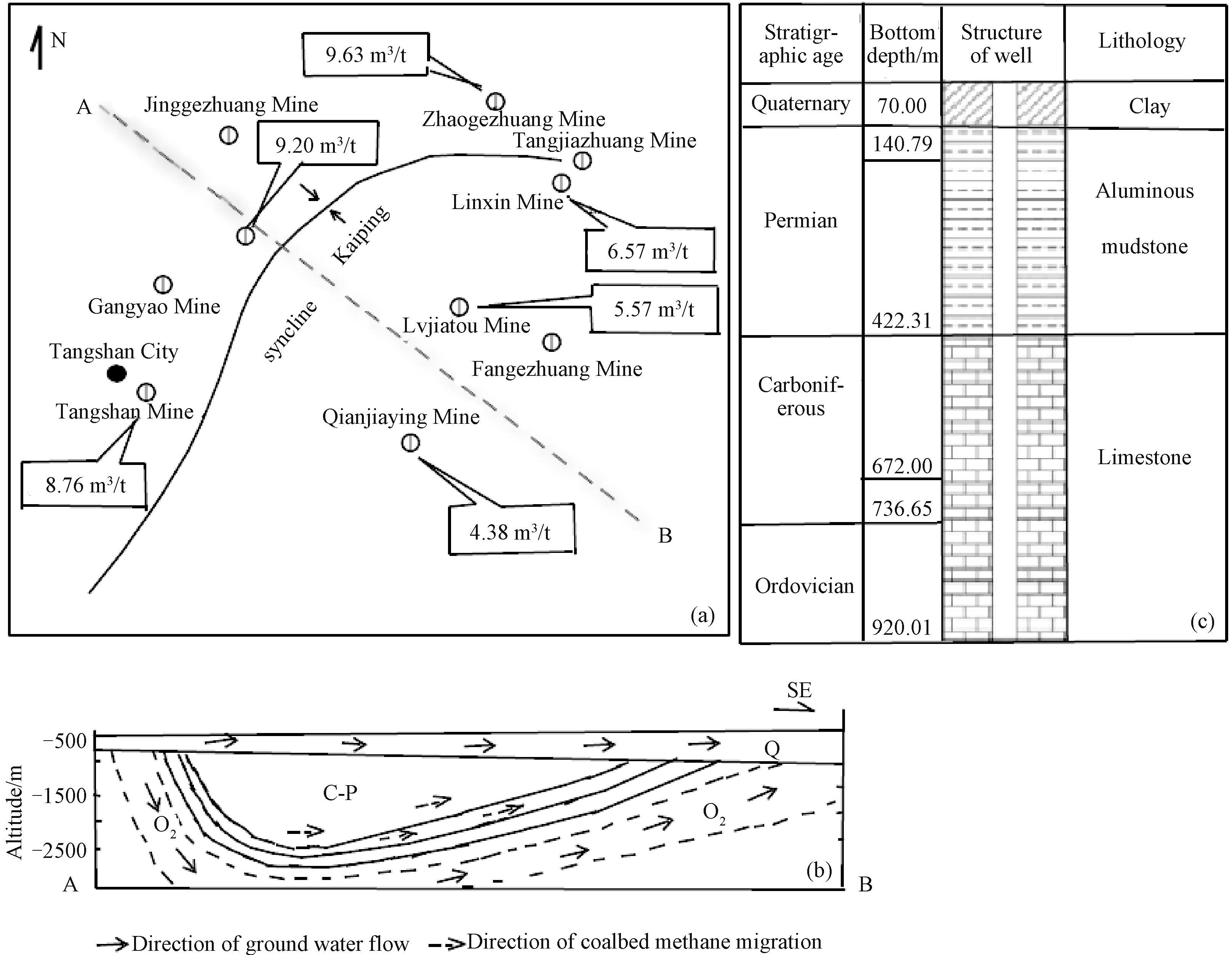
Figure 1 Plan of Kaiping syncline (a) and profile of groundwater runoff direction(b) (according to Ma Bingtai) and histogram of wellhole in Majiagou Mine(c)
The western side of Kaiping District in the east of Tangshan City,where Majiagou Mine is located,has relatively flat terrain,and the eastern residential area is the concentration zone of sporadically outcropped bedrock(Fig.2),which is the main recharge area of the aquifer.The western residential area is all covered by Quaternary clay layer with an average thickness of about 2 m.The relative elevation difference between the east and west is about 23 m (Guo Da et al.,1994).
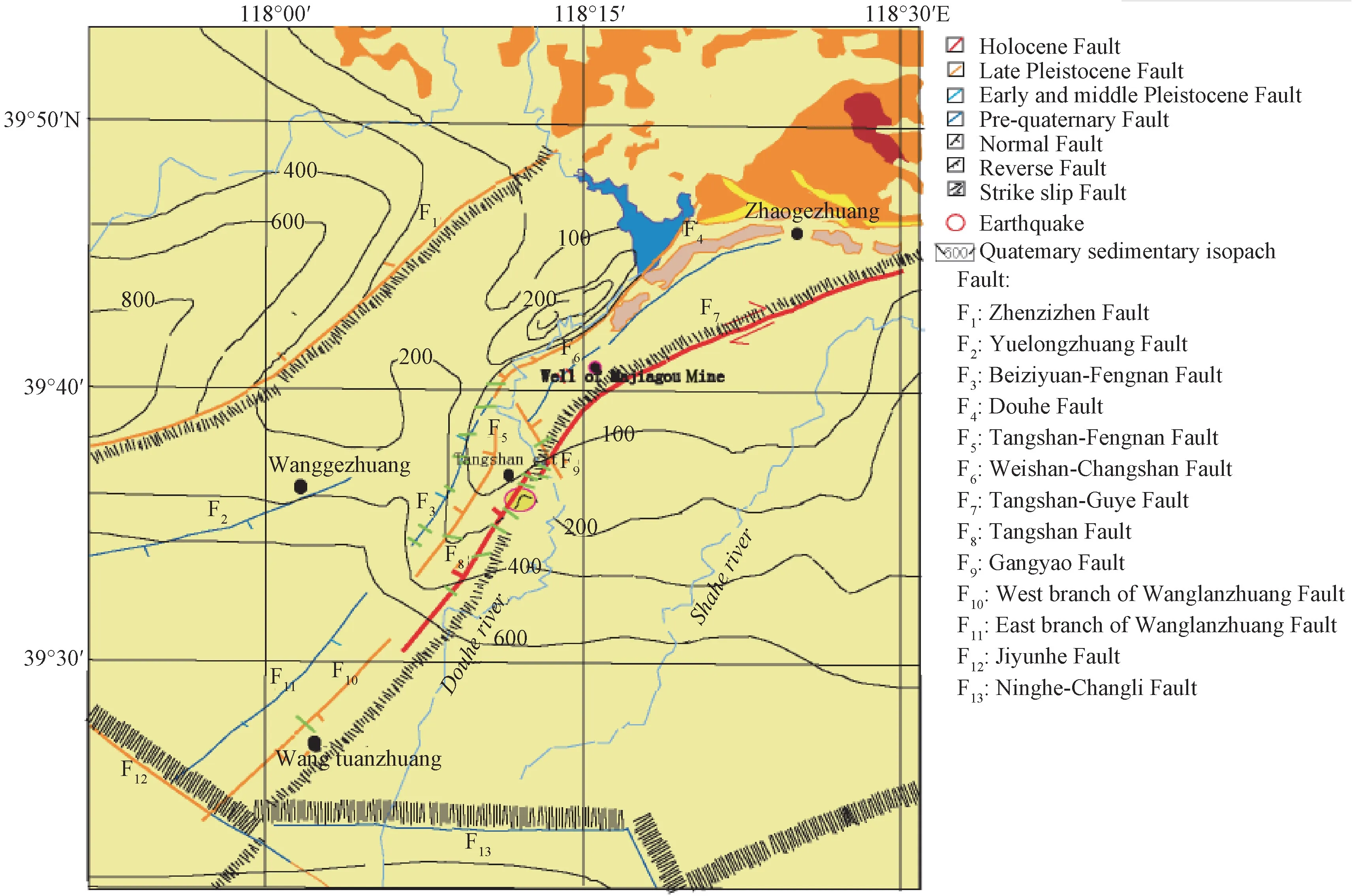
Figure 2 Map of geological structure position of Majiagou Mine
2 ANALYSIS OF VARIATION CHARACTERISTICS
2.1 Analysis of Annual Variation Characteristics of Water Level
The annual dynamic change of water level in Majiagou Mine shows obvious sudden rise in rainy seasons,and the periods of low water level are concentrated at the end of the year and the beginning of the following year.As shown in Fig.3,the change of water level in rainy seasons appears to have a positive correlation with precipitation,possibly due to the groundwater recharge provided by rainfall infiltration.However,the annual rainfall and the rise of water level are not completely synchronized.For example,the highest precipitation in 2012 corresponds to moderate-degree rise of water level,while the large rise of water level in 2005 is corresponding to moderate precipitation.Admittedly,the concentration degree of rainfall may influence their relationship.However,from the morphological analysis of the sudden rise of water level after rainfall,it is impossible to infiltrate 730 m to the observation layer in such a short time after rainfall.Because that the well histogram shows that the upper layer is 70 m thick Quaternary clay layer.Additionally,there is a 350 m thick Permian aluminum mudstone below,which also has a low infiltration coefficient.Based on the analysis of the tectonic position of the wellhole,the western part of Kaiping area is relatively flat,the western residential area is all covered by Quaternary clay layer with an average thickness of about 2 m,and the eastern residential area is the concentration zone of sporadically outcropped bedrock,which is the main recharge area of the aquifer and has a certain distance from the aquifer (Guo Da et al.,1994).In addition,according to the geological data of local water level (Fig.2(b)),the runoff direction of the Ordovician limestone aquifer is consistent with the distribution of Kaiping syncline,flowing from the northwest to the southeast of Majiagou mining area (Ma Bingtai et al.,2016).Therefore,the sudden rise of well water level after rainfall should not be caused by the increase of aquifer water content due to the recharge of sporadically outcropped bedrock in the east.Instead,the aquifer must be replenished and then lead to the rise of water level after a period of time.
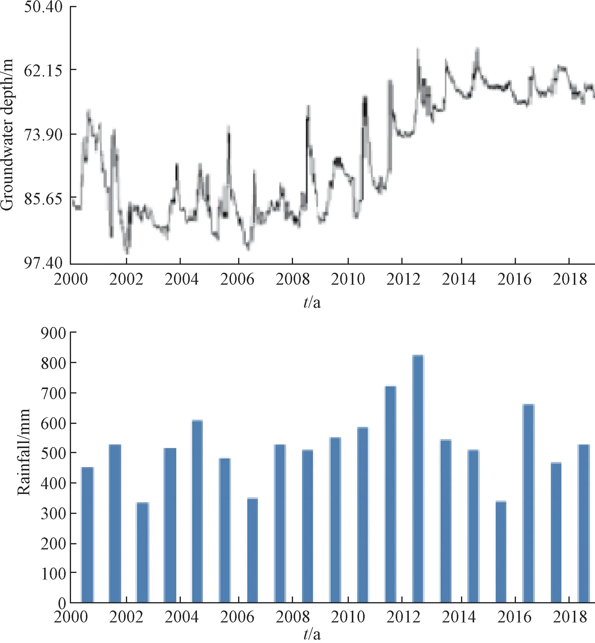
Figure 3 Comparison of water level(top) and regional rainfall(bottom) in Majiagou Mine
The possible reason for the rapid rise of water level is that the rainfall load effect may lead to the desorption of coalbed methane,and the resulting gas expansion may produce pressure to act on the observed aquifer.In the coal-preserved structure belt at the southern foot of Yanshan Mountains,the coal seams in Jiyu,Chezhoushan and Kaiping are the thickest,and the carboniferous and Permian strata exposed in Majiagou Mine are 666.65 m thick.The gas content of Majiagou and Zhaogezhuang coal mine are relatively high,with a maximum of more than 11 m3/t (Fig.1(a)).Due to the development of reverse fault in Majiagou coal mine,the gas emitting path is impeded,leading to an obviously higher CBM content in the coal seam.Among them,gas content of No.9 coal is closely related to the buried depth,and the fitting relation are detailed:Q=0.0137H-3.5521,correlation coefficientR2=0.88,that is,it can exceed 8 m3/t at a buried depth of 880 m(Zhang Lusuo,2010).However,the dip angle of coal-bearing strata in Tangshan mining area,which also locates in the northwest wing of Kaiping syncline,is relatively small,and the gas content is also relatively low,all less than 8 m3/t (Liu Yisheng et al.,2015).Besides,the water level of the seismic observation well in Tangshan Mine in the mining area does not show the rapid rise as that in Majiagou Mine.Different from conventional natural gas,coalbed methane mainly occurs in the coal matrix in a state of adsorption,together with a small amount of free gas and water-dissolved gas (Qin Shengfei et al.,2005).Therefore,it is highly possible that coalbed methane in the overlying carboniferous and Permian coal seam is precipitated and then expanded under rainfall load effect,whereby they are loaded into the observed aquifer at the lower strata,causing the rapid rise of water level.
2.2 Analysis of Multi-Year Variation Characteristics of Well Water Level
As shown from the water level curve in Fig.4,the well water level in Majiagou Mine has experienced 2 upward trend changes since 1991,which are the time period of 1993-1998 and 2008-2014,respectively.By comparing the rainfall data of Tangshan in Fig.4,it can be seen that although the rainfall in 1994,1995 and 1998 is relatively large in the period of 6-years'rise from 1993 to 1998,the total rainfall is relatively low,not exceeding a maximum of 350 mm,and the influence is limited to a short period of time.The rise-fall process from 1993 to 2003 is comparable to the water level changes in 6 other wells in Tangshan and Qinhuangdao,and the water level changes in the 6 wells include three multi-year cycles from 1982 to 2018 (Fig.5).The Luannan Well in Tangshan and Changli Well in Qinhuangdao are not at the same hydrogeological unit with the Tangshan Mine,Fengnan Well and Yutian Well in Tangshan,but they have comparable processes of changes.Furthermore,although there are measures to reduce groundwater exploitation in Tangshan area,they cannot completely affect the multi-year changing processes that can be compared with other wells.We have studied the relationship between the components of the first two multi-year cycles of 6 wells in Tangshan and Qinhuangdao area and the earthquakes in north China.Most of the strong earthquakes in north China occur in the period of high water level,it is believed that the multi-year high-value variation of water level contains the information of enhanced stress field (Zhang Suxin et al.,2008).During the period of rising water level from 2008 to 2014,although only oneM≥5.0 earthquake has occurred in North China (DengtaM5.1 earthquake in Liaoning),several significant earthquakes of magnitude 4 or above have occurred in the former earthquake region in Tangshan(Fig.4),indicating high crustal stress level during this period.Therefore,we suggest that the multi-year changing process of the well water level is similar to that of the other 5 wells,which contains the enhanced information of regional stress field change.
2.3 Seismic Activities Support the Information of Stress Field Changes
In this study,moderate earthquake activities in former earthquake area in Tangshan are analyzed.Since 1990,several earthquakes with the magnitude ofML4.5 or above have occurred in Tangshan area,including theM5.2 earthquake on May 29th,1991 and theM5.6 earthquake on May 30th,theM5.4 earthquake on October 6th,1995,theM5.0 earthquake on April 14th,1998,theM4.8 earthquake on March 6th,2010,theM5.1 earthquake on May 28th,2012 and theM4.6 earthquake on September 10th,2016.These earthquakes all occur in the periods of rising water level or high water level in Majiagou Mine (Fig.5).The occurrence of these earthquakes proves that the crustal stress level is high in this region,also indicates that the multi-year upward trend of water level contains the information of enhanced regional stress field.
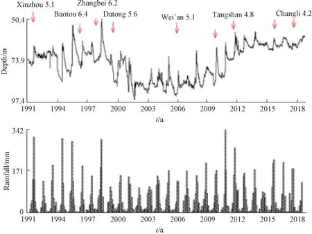
Figure 4 Multi-year dynamic curve of water level in Majiagou Mine and drop line of rainfall in Tangshan
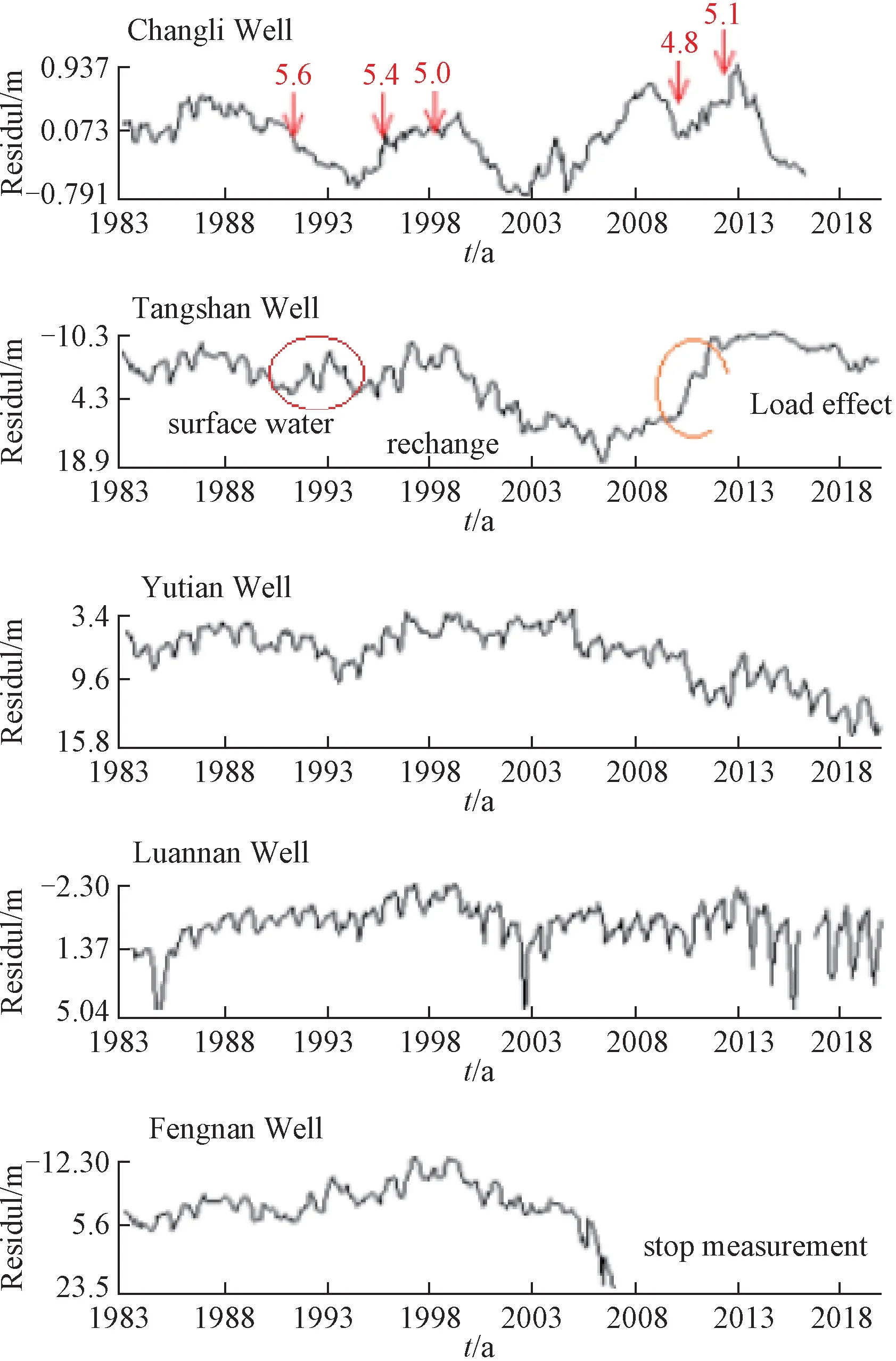
Figure 5 Graphs of water level of 5 wells in Tangshan and Qinhuangdao area
Moderate to strong earthquake activities in North China are also analyzed.Since 1990,earthquakes with the magnitude ofML5.0 or above have occurred in North China,including the DatongM6.1 earthquake in 1989,the XinzhouM5.1 earthquake in 1991,the DatongM5.8 earthquake in 1991,the TangshanM5.1 earthquake in 1991,the BaotouM6.4 earthquake in 1996,the ZhangbeiM6.2 earthquake in 1998,the ZhangbeiM5.6 earthquake in 1999,the DatongM5.6 earthquake in 1999 and the Wen'anM5.1 earthquake in 2006.Similarly,these earthquakes also occur in the periods of rising water level or high water level in Majiagou Mine,indicating that the multi-year upward trend of water level contains the information of enhanced regional stress field (Zhang Suxin et al.,2002).In the period of variations of high water level in Majiagou Mine since 2008,noM≥6.0 earthquake has occurred in North China,only one earthquake ofM5.1 has occurred in Dengta,Liaoning,and an earthquake ofM4.4 has occurred in Yangqu,Shanxi.However,under the seismically quiescent circumstance where noM≥5.0 andM≥6.0 earthquakes in North China for many years,several significant earthquakes ofM≥4.0 have occurred in Tangshan old earthquake area (Fig.4),indicating that the crustal stress level is relatively high during this period.
3 DISCUSSION AND CONCLUSION
Based on the tectonic position of Majiagou Well and its relationship with local moderate earthquakes and strong earthquakes in North China,the study suggests that Majiagou Well is located in the sensitive part of the structure and is one of the most earthquake-reflective wells which monitors the underground fluid level in North China.From the analysis of the annual variation curves of water level in Majiagou Mine,and the rise of water level in rainy season,it is intuitively clear that there is a positive correlation between the rainy season and water level.However,after analyzing the comparison regarding the sudden rise pattern which is similar to a positive pulse after rainfall,the CBM content of the overlying coal seam,the location of recharge area and thickness of the covering layer,the under-crossing water-blocking thrust fault and the Tangshan Mine Well,as well as the low gas content in the overlying coal seam which is also located in the northwest wing of Kaiping syncline.We suggest that the rise of water level in after rainfall Majiagou Mine Well is associated with the rainfall load effect which leads to the desorption of coalbed methane in the overlying carboniferous-Permian coal seam,and the gas expansion that produces pressure to act on the observed Ordovician aquifer.
The multi-year changing pattern of water level in Majiagou Mine shows that the water level varies from rising trend period,to stable high value period,to decreasing trend period,then to rising trend period again.Although the trend change is related to the local precipitation and groundwater exploitation,it does not affect the overall trend change pattern.The comparative analysis with water level of five wells in different hydrogeological units in Tangshan and Qinhuangdao indicates that the regional water level variation over the years are comparable.Based on the analysis of the multi-year change of water level and moderate to strong earthquakes in North China,we indicate that the multi-year upward changes of water level contain the information of enhanced regional stress field.
 Earthquake Research Advances2020年2期
- Earthquake Research Advances的其它文章
- Influence of Bedding and Mineral Composition on Mechanical Properties and Its Implication for Hydraulic Fracturing of Shale Oil Reservoirs1
- Progress and Prospect of Geophysical Research on Underground Gas Storage:A Case Study of Hutubi Gas Storage,Xinjiang,China1
- Analysis of Anomalous Characteristics of Regional Crustal Deformation before the September 16th,2019 Zhangye MS5.0 Earthquake,Gansu,China1
- Study of the Seismogenic Structure of the October 12th,2019 MS 5.2 Beiliu Earthquake,Guangxi,China1
- Analysis of Power Supply Interference of Geomagnetic Second Data Observation-Take Changli Seismic Station as An Example1
- Microseism Variations in Response to Antarctic Seasonal Changes in Sea Ice Extent1
