
GNSS-R海面风场数据处理技术探讨
2020-06-15 03:25刘原华冯琳芳牛新亮
导航定位学报 2020年3期
刘原华,冯琳芳,牛新亮
GNSS-R海面风场数据处理技术探讨
刘原华1,冯琳芳1,牛新亮2
(1. 西安邮电大学 通信与信息工程学院,西安 710121;2. 中国空间技术研究院 西安分院,西安 710000)
为进一步提高海面风速反演精度,提出1种基于GNSS-R的海面风场数据处理技术:指出需要进行功率校准的原因是由于接收机增益随温度变化,使接收到的信号功率(校准前)受温度影响,导致在不同温度环境下,反演风速不一致;给出接收到的信号功率、噪声功率以及当载荷信号源变为定标负载时的噪声功率随温度的变化规律,分析利用3者之间的关系,可消除温度对功率的影响,从而实现功率校准。实验结果表明,星载条件下应用该功率校准过程的反演精度可提高4.5158 m/s,能够有效消除温度对风速反演结果的影响。
全球卫星导航系统反射信号;风速反演;功率校准;噪声功率
0 引言
全球卫星导航系统反射信号(global navigation satellite system-reflection, GNSS-R)技术是利用导航卫星的反射信号,提取出反射面特征要素的技术。自20世纪90年代以来,国内外学者及研究机构已成功将GNSS-R技术应用到多个领域,如海洋盐度探测[1]、土壤湿度探测[2-3]、海面风场探测[4-6]等。
文献[7]于1998年进行了机载平台下的海风探测实验。2002年,文献[8]首次在星载平台上探测到全球卫星导航系统(global navigation satellite system, GNSS)反射信号。2014年发射升空的TDS-1卫星上搭载了SGR-ReSI(remote sensing instrument)型号的GNSS遥感接收机,用于生成大量的延迟多普勒图(delay-Doppler map, DDM)[9]。2016年12月,美国国家航空航天局(The National Aeronautics and Space Administration, NASA)部署了由8颗微卫星组成的旋风全球卫星导航系统(cyclone global navigation satellite system, CYGNSS)。文献[10]利用CYGNSS数据进行星载平台下GNSS-R海面高风速反演的研究。
GNSS-R海面风场反演理论是通过研究海面统计特性(以海面粗糙度为核心)、海面散射模型、能量谱模型及散射信号相关功率模型等建立海面风场与海面散射信号功率之间的关系[11]。由此可知,散射信号功率是影响海面风场反演结果的重要参数。国内外现有的研究主要基于风速反演的方法及模型[10,12-17],对信号功率的研究相对较少。
本文结合星载条件下的实测数据,分析进行功率校准的原因;对功率校准的具体过程进行研究,分析了接收到的信号功率、噪声功率以及当载荷的信号源变为定标负载时的噪声功率随温度的变化规律;最后实行了功率校准。
1 功率校准的原因
本文使用捕风一号卫星地面测试阶段数据,利用散射信号相关功率模型,将散射信号功率转换为归一化双基雷达横截面(normalized bi-static radar cross section, NBRCS),并从中计算出反演所用可观测量,通过回归分析,为可观测量建立起经验地球物理学模型函数(geophysical model function, GMF)来进行海面风速反演[17]。
风速反演的结果如图1所示,风速反演误差如图2所示。从图1及图2可以看出,反演的风速趋向于2条不重合的反比例函数曲线,反演风速的均方根误差(root mean square error, RMSE)为7.0286 m/s。
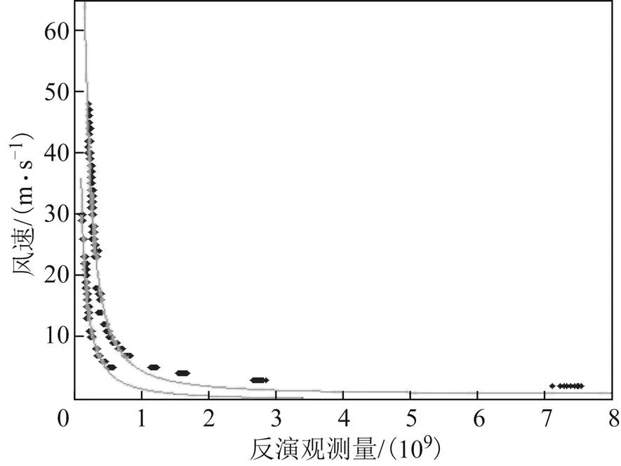
图1 风速反演结果
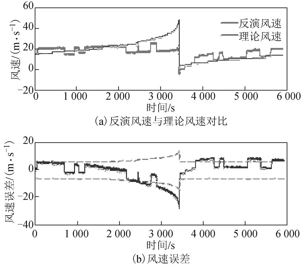
图2 反演误差
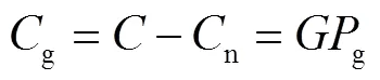
散射信号功率与风速反演的结果密切相关,而接收机接收到的散射信号功率包含在接收到的总功率之中。在星载平台下,每个航天器都带有载荷,能够定位和跟踪地球表面上的GNSS反射信号,并在一系列时间延迟和多普勒频率上绘制信号功率。
由载荷生成的DDM的每个像素都是未经校准的原始数据。除了海面散射GNSS信号外,总信号功率还包括来自地球和载荷本身产生的热辐射的贡献。总信号功率是所有输入信号功率的和再乘以接收机的增益[18],即有
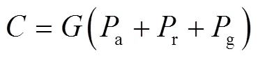
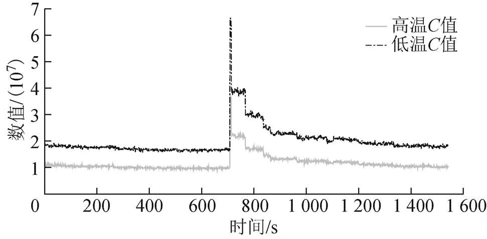
图3 接收到的总功率值C值
根据上述分析可以得出:随温度的升高而减小,导致高低温环境下值的不一致。因此需要对接收到的总信号功率进行校准。
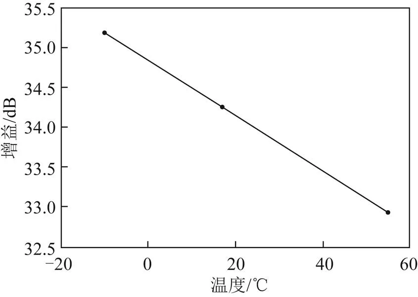
图4 增益G与温度的关系
2 噪声功率的计算
2.1 天线背景噪声功率
天线背景噪声功率一般可以表示为
2.2 定标负载噪声功率
定标负载的噪声功率为
2.3 接收机热噪声功率
3 功率校准与分析
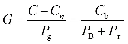
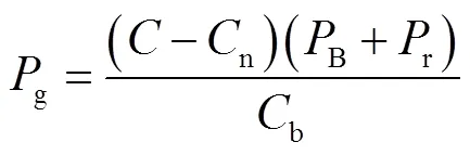
由载荷生成的DDM包括许多不存在信号功率的延迟单元,这些单元提供了DDM中噪声功率的估计值,即
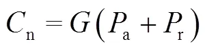


图5 不同温度环境下的和
由式(6)和式(7)得到估算的接收机增益为

将捕风一号卫星的DDM进行功率校准,利用校准后的功率再次对风速进行反演,得到的反演结果如图7所示,反演误差如图8所示。与图1、图2(未进行功率校准)相比:经过功率校准后,高温和低温环境下反演风速趋向于2条不重合反比例函数曲线这一现象消失;反演风速的均方根误差为2.5128 m/s,与功率校准前相比,反演精度提高了4.5158 m/s。
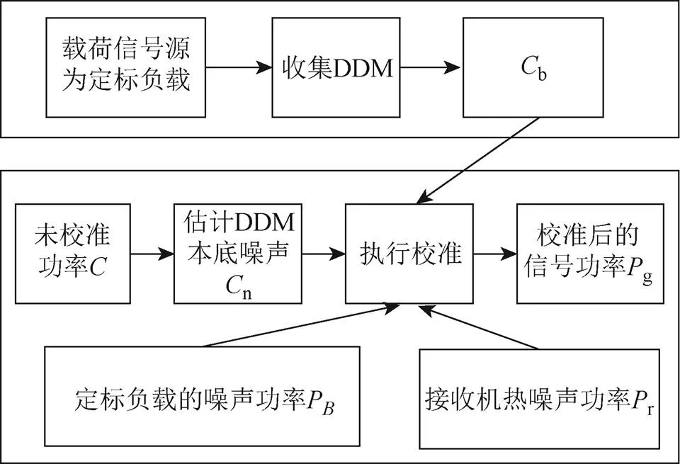
图6 功率校准流程
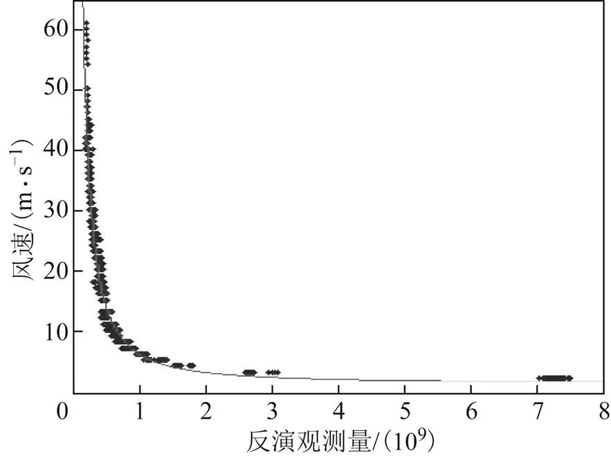
图7 风速反演结果
4 结束语

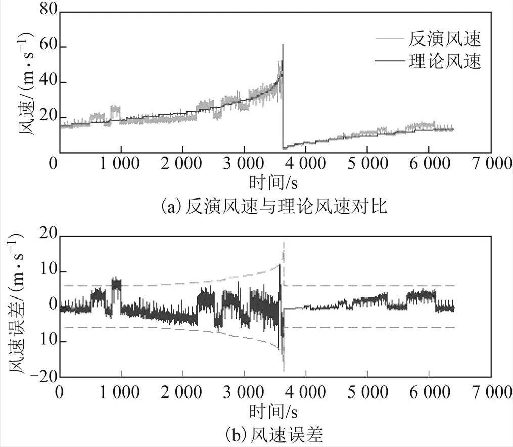
图8 反演误差
[1] KAINULAINEN J, RAUTIAINEN K, LEMMETYINEN J, et al. Detection of a sea surface salinity gradient using data sets of airborne synthetic aperture radiometer HUT-2-D and a GNSS-R instrument[J]. IEEE Transactions on Geoscience and Remote Sensing, 2011, 49(11): 4561-4571.
[2] RODRIGUEZ-ALVAREZ N, BOSCH-LLUIS X, CAMPS A, et al. Soil moisture retrieval using GNSS-R techniques: experimental results over a bare soil field[J]. IEEE Transactions on Geoscience & Remote Sensing, 2009, 47(11): 3616-3624.
[3] MIRONOV V L, MUZALEVSKIY K V. The new algorithm for retrieval of soil moisture and surface roughness from GNSS reflectometry[C]//The Institute of Electrical and Electronic Engineers(IEEE). IEEE International Geoscience and Remote Sensing Symposium(IGARSS). Münich: IEEE, 2012: 7530-7532.
[4] SCHIAVULLI D, GHAVIDEL A, CAMPS A, et al. GNSS-R wind-dependent polarimetric signature over the ocean[J]. IEEE Geoscience and Remote Sensing Letters, 2015, 12(12): 2374-2378.
[5] RODRIGUEZ-ALVAREZ N, AKOS D M , ZAVOROTNY V U, et al. Airborne GNSS-R wind retrievals using delay-
Doppler maps[J]. IEEE Transactions on Geoscience and Remote Sensing, 2013, 51(1): 626-641.
[6] ZAVOROTNY V U, VORONOVICH A G. GNSS-R delay-Doppler maps of ocean surface at weak winds[C]//The Institute of Electrical and Electronic Engineers(IEEE). IEEE International Geoscience and Remote Sensing Symposium (IGARSS). Forth Worth, Texas: IEEE, 2017: 2664-2666.
[7] GARRISON J L , KATZBERG S J , HILL M I. Effect of sea roughness on bistatically scattered range coded signals from the global positioning system[J]. Geophysical Research Letters, 1998, 25(13): 2257-2260.
[8] LOWE S T, LABRECQUE J L, ZUFFADA C, et al.First spaceborne observation of an Earth-reflected GPS signal[J]. Radio Science, 2002, 37(1): 1-28.
[9] Surry Satellite Technology LTD. Mission description-GNSS reflectometry on TDS-1 with the SGR-ReSI[EB/OL]. [2019-12-27]. http: //merrbys. co. uk/wp-content/uploads/2017/07/TDS-1-GNSS-R-Mission-Description. pdf.
[10] CYGNSS Science Team. CYGNSS mission [EB/OL].[2019-12-27]. http://clasp-research.engin.umich.edu/ missions/cygnss/.
[11] 杨东凯, 张其善. GNSS反射信号处理基础与实践[M]. 北京: 电子工业出版社, 2012: 164-174.
[12] WANG Xin, SUN Qiang, ZHANG Xunxie, et al. First China ocean reflection experiment using coastal GNSS-R[J]. Chinese Science Bulletin, 2008, 53(7): 1117-1120.
[13] RODRIGUEZ-ALVAREZ N, GARRISON J L. Generalized linear observables for ocean wind retrieval from calibrated GNSS-R delay-doppler maps[J]. IEEE Transactions on Geoscience & Remote Sensing, 2015, 54(2): 1142-1155.
[14] WANG Feng, YANG Dongkai, ZHANG Bo, et al. Wind speed retrieval using coastal ocean-scattered GNSS signals[J]. IEEE Journal of Selected Topics in Applied Earth Observations & Remote Sensing, 2016, 9(11): 5272-5283.
[15] 杨东凯, 张益强, 张其善, 等. 基于GPS散射信号的机载海面风场反演系统[J]. 航空学报, 2006, 27(2): 310-313.
[16] YANG Dongkai, ZHANG Yiqiang, LU Yong, et al. GPS reflections for sea surface wind speed measurement[J]. IEEE Geoscience & Remote Sensing Letters, 2008, 5(4): 569-572.
[17] CLARIZIA M P, RUF C S. Wind speed retrieval algorithm for the cyclone global navigation satellite system (CYGNSS) mission[J]. IEEE Transactions on Geoscience and Remote Sensing, 2016, 54(8): 4419-4432.
[18] GLEASON S, RUF C S, CLARIZIA M P, et al. Calibration and unwrapping of the normalized scattering cross section for the cyclone global navigation satellite system[J]. IEEE Transactions on Geoscience & Remote Sensing, 2016, 54(5): 2495-2509.
Discussion on GNSS-R sea surface wind field data processing technology
LIU Yuanhua1, FENG Linfang1, NIU Xinliang2
(1. College of Communications & Information Engineering, Xi’an University of Posts & Telecommunications, Xi’an 710121, China;2. Xi’an Branch of China Academy of Space Technology, Xi’an 710000, China)
In order to further improve the inversion accuracy of sea surface wind speed, the paper proposed a sea surface wind field data processing technology based on GNSS-R: the reason for the power calibration was indicated that the receiver gain changed with temperature to make the received signal power (before being calibrated) affected by temperature, leading to the inconsistent inversion of wind speed under different temperature environments; and the change rule among the temperature and three parameters of the received signal power, the noise power and the noise power when the signal source of load becomes a calibration load was given, then it was analyzed that the influence of the temperature on the power could be eliminated by utilizing the relationship among the three parameters, to realize the power calibration finally. Experimental result showed that under spaceborne conditions, the inversion accuracy using the proposed method would be improved by 4.5158 m/s, illustrating that the effect of temperature on wind speed inversion results could be effectively eliminated.
global navigation satellite system-reflection (GNSS-R); wind speed inversion; power calibration; noise power
P228
A
2095-4999(2020)03-0076-80
刘原华,冯琳芳,牛新亮. GNSS-R海面风场数据处理技术探讨[J]. 导航定位学报, 2020, 8(3): 76-80.(LIU Yuanhua, FENG Linfang, NIU Xinliang. Discussion on GNSS-R sea surface wind field data processing technology[J]. Journal of Navigation and Positioning, 2020, 8(3): 76-80.)
10.16547/j.cnki.10-1096.20200312.
2019-01-09
西安市科技计划项目(GXYD17.1)。
刘原华(1983—),女,陕西西安人,博士,副教授,硕士生导师,研究方向为卫星通信、导航和遥感。
冯琳芳(1991—),女,陕西西安人,硕士研究生,研究方向为卫星通信、海面风场反演。
猜你喜欢
中等数学(2022年5期)2022-08-29
军民两用技术与产品(2022年7期)2022-08-06
科学导报(2022年42期)2022-07-13
大气科学学报(2022年2期)2022-05-12
导航定位学报(2022年1期)2022-02-17
科技研究·理论版(2021年20期)2021-04-20
中国电气工程学报(2019年18期)2019-10-21
电子制作(2019年24期)2019-02-23
学校教育研究(2018年8期)2018-07-09
地震研究(2017年3期)2017-11-06
