基于Sentinel-1双极化雷达影像的土壤含盐量反演
马 驰
基于Sentinel-1双极化雷达影像的土壤含盐量反演
马 驰
(辽宁省交通高等专科学校,沈阳 110122)
该文以松嫩平原土地盐碱化区域-大庆市为研究区,Sentinel-1双极化雷达影像为数据源,结合研究区土壤采样的全盐含量测量值,反演研究区表层土壤含盐量。首先,在研究区进行土壤采样,并在实验室化验土壤样品的全盐含量,利用S1TBX软件对雷达影像进行噪声处理、辐射校正、几何校正;然后通过分析雷达影像不同极化组合的后向散射系数与土壤含盐量之间的关系,确定最优的极化组合方式;最后,利用回归分析的方法建立土壤含盐量的反演模型并进行精度评价。研究结果显示:(VV2+VH2)/(VV2-VH2)极化组合的后向散射系数可以较好的分离不同含盐量的土壤,建立起来的反演模型,决定系数2达到0.872,均方根误差RMSE为0.988。该研究可以满足大区域土地盐碱化监测的需要,并为Sentinel-1 雷达数据在土壤成分提取等方面研究提供了参考。
遥感;土壤;盐分测量;反演;Sentinel-1
0 引 言
土壤盐碱化易发生于干旱、半干旱地区。主要由于灌溉过程不当或排水不畅导致地下水位上升至地表,水分蒸发后盐分在地表累积,土壤中盐分含量过高(超过0.3%),从而形成土壤环境灾害[1-3]。随着气候变化和人类对土壤资源的不当利用,中国一些地区土壤不同程度的退化[4-5]。松嫩平原西部是中国最大苏打盐碱土区[6-7],土壤含盐量的升高造成了农作物不同程度的减产甚至绝收,严重影响了区域农业生产和土地资源的可持续利用。因此,及时监测土壤含盐量对合理利用土地资源、防止区域土地盐碱化进一步恶化具有重要意义。
遥感技术具有数据获取快速、投入成本少、监测范围广等优点,在土壤成分预测等方面的研究已经表现出巨大潜力[8-10]。近年来,国内外诸多学者相继展开了利用遥感技术监测土地盐碱化的研究[11-12]。在盐碱化土壤信息提取方面,经历了由定性分类到定量反演的过程,如张佩民等[13]利用MSS和ETM遥感影像采用人机交互解译的方法提取了青藏高原两期盐碱土信息,并分析了近30 a来研究区土地盐碱化的时空变化规律,王爽等[14]将TM遥感影像与ASD光谱仪野外光谱测量数据相结合,并联合土壤含盐量实测数据建立反演模型提取新疆渭干河-库车河三角洲绿洲地区土壤盐碱化信息;在遥感影像的选取上,经历了从多光谱到高光谱的发展过程,如王耿明等[15]利用ASTER多光谱遥感影像建立了松辽平原土壤含盐量的多元预测模型,朱高飞等[16]利用HJ1A高光谱影像对玛纳斯县盐碱土区土壤含盐量进行了预测。
由于微波遥感技术具有全天时、全天候的观测能力,对云雾、雨雪及地表植被等具有一定的穿透能力,弥补了可见光遥感的局限性,可以更好的识别地表地物、提取地表信息,在土壤成分信息提取等方面具有较大潜力与优势[17-19]。Sentinel-1是欧空局于2014年4月发射的双极化雷达成像卫星,能够获取连续的、全天候地表雷达影像,为土壤成分信息获取等方面的研究提供了新的数据源[20-21]。然而,利用Sentinel-1 SAR影像提取土壤含盐量的研究还鲜有报道。本文利用Sentinel-1 SAR影像数据,以大庆市为研究对象,结合土壤实地采样的化验数据,反演研究区土壤含盐量,以期为区域土地盐碱化的防治与土壤环境恢复提供数据支持。
1 材料与方法
1.1 研究区概况
研究区位于松嫩平原中部、杜尔伯特县南部、大庆市全部、肇州县与肇源县北部、安达市西部,124°~125°24′ E、45°36′~46°48′ N,气候属半干旱大陆性季风气候:春季干旱多大风、夏季温热多雨、秋季晴朗多寒潮、冬季寒冷少雪,多年平均降水量400~550 mm,且由东南向西北递减。徐白山等[22-23]研究表明,松嫩平原盐碱化土壤的平均含水量为15%~20%。研究区内地势平坦,平均海拔130 m~200 m,中西部地区湖沼众多,容易形成土壤盐碱化灾害[24]。
1.2 土壤采样及测量
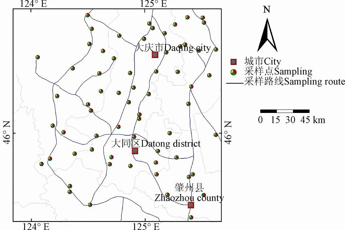
作者于2015年6月15日至16日深入研究区进行土壤采样(图1),采样点选在视野开阔并无树木等遮挡的裸土区域,在20 m×20 m范围内地表0~20 cm深度采集4点土壤、混合约1 kg作为一个土样放入采集袋,共采集土壤样品64个,并用手持GPS接收机测量采样点经纬度坐标用以获取雷达影像中对应采样点的后向散射系数。将土壤样品在实验室自然风干,剔除植物根须和小石块等杂质,研磨并过1 mm筛。将土样按水土5:1比例提取浸取液,并采用干残渣法测量每个土样的全盐含量。

图1 采样点分布图
1.3 雷达影像的获取与处理
选择2015年6月14日获得的标准双极化Sentinel-1 SAR影像1景,雷达影像的工作波段为C波段,极化方式为VH和VV,影像成像方式为干涉宽幅模式(interferometric wide swath,IW)。雷达影像获取时间与土壤采样时间接近同步,有利于真实反映地表信息。由于本文选取的Sentinel-1 SAR影像产品为Level 1级干涉宽幅影像,需要对雷达影像进行数据预处理,主要包括:影像噪声处理、辐射校正、影像精几何校正等,影像处理选择欧空局开发的Sentinel-1数据处理软件(S1TBX)。具体步骤为:1)合成孔径雷达的成像机制使得SAR影像出现大量随机分布的斑点噪声,严重影响其在土壤含盐量反演中的精度。为了抑制斑点噪声的影响,本文利用S1TBX软件的Speckle Filtering功能模块对选择的雷达影像进行斑点噪声处理。经过试验,将滤波器设置为Refined Lee,阈值设置为5 000;2)利用Radiometric-Calibrate模块对雷达影像进行辐射校正,将影像的灰度值转化为地表地物的雷达后向散射系数;3)合成孔径雷达侧视成像的机理使得SAR影像带有很大的几何畸变,需对其进行几何精校正。本文利用Terrain Correction功能模块的Range Doppler 方法,参考研究区1:5万地形图,对Sentinel-1 SAR影像进行几何精校正。
1.4 模型建立及其验证
参考前人制定的盐碱土分类原则[25-26],将研究区盐碱化土壤分为轻度盐碱化土壤(土壤含盐量1~3 g/kg)、中度盐碱化土壤(土壤含盐量3~5 g/kg)、重度盐碱化土壤(土壤含盐量5~7 g/kg)以及盐碱土(土壤含盐量大于7 g/kg)。选择均匀覆盖研究区的52个土样作为建模样本,12个土样作为检验样本(表1)。土壤样品个数及含盐量的描述统计表中显示,建模组与检验组中各种类型盐碱化土壤样本分布较均匀,土壤含盐量的平均值和标准差相近,有利于提高研究区土壤含盐量反演精度。

表1 土壤样品个数及含盐量的描述统计
诸多学者的研究结果表明,将雷达影像波段进行适当的组合可以有效削弱影像中噪声对地物后向散射系数的影响,提高雷达影像后向散射系数与土壤含盐量的相关性[27-29]。本文通过前期试验,选取代表性的VV+VH、VV/VH、(VV+VH)/(VV-VH)、(VV2+VH2)/(VV2-VH2)等4种极化组合方式,计算4种极化组合的后向散射系数,将建模样本含盐量的化验值与其在Sentinel-1 SAR影像上对应的后向散射系数(极化组合的后向散射系数)在SPSS软件中进行回归分析,建立研究区土壤含盐量的反演模型;利用土壤含盐量的反演模型与检验样本在Sentinel-1 SAR影像上的后向散射系数(极化组合的后向散射系数)计算检验样本土壤含盐量的反演值,与其实测值比较,获得土壤含盐量的反演误差式(1)及相对误差式 (2),衡量反演模型的反演精度。


2 结果与分析
2.1 土壤含盐量的后向散射系数分析
为了分离不同程度的盐碱化土壤,根据采样点含盐量的化验值与不同含盐量土壤在雷达影像上对应的后向散射系数进行分析可知,Sentinel-1 SAR影像同极化方式(VV)对土壤含盐量的响应明显高于不同极化方式(VH)。VV极化方式的后向散射系数随着土壤含盐量的升高而增大;除重度盐碱化(含盐量5.8 g/kg)外,VH极化方式的后向散射系数随着土壤含盐量的升高总体上呈增大趋势(表2)。

表2 典型地物不同极化及极化组合的后向散射系数
由表2可知,对于水体及4个不同含盐量的土壤样品,VV+VH极化组合方式后向散射系数总体上呈上升趋势,对于水体、轻度盐碱土有较好的区分能力,但中度盐碱化与重度盐碱化土壤的后向散射系数相对于土壤含盐量的变化率仅为1.1%,难以很好的分离中度与重度盐碱化土壤;VV/VH极化组合方式的后向散射系数在水体至轻度盐碱化土壤呈上升趋势,轻度盐碱化土壤至盐碱土呈下降趋势,难以分离水体;(VV+VH)/(VV-VH)极化组合方式可以很好提取水体,但不同含盐量土壤的后向散射系数没有明确的规律性,难以分离不同含盐量的土壤;(VV2+VH2)/(VV2-VH2)极化组合方式,其后向散射系数随土壤含盐量的升高而减小,后向散射系数相对于土壤含盐量的变化率最小值为15.5%,且各种盐碱化程度的分离性较好,不易产生混淆。因此,本文选择(VV2+VH2)/(VV2-VH2)极化组合方式作为研究区土壤含盐量提取指数。
2.2 反演模型建立
将采集的64个土壤样品分为2部分:随机选取52个作为建模样本,利用回归分析的方法建立土壤含盐量反演模型,剩下的12个土壤样品用于反演模型的检验,并选择(VV2+VH2)/(VV2-VH2)极化组合建立土壤含盐量的反演模型,探究Sentinel-1 SAR影像后向散射系数与研究区土壤含盐量的关系(图2)。

图2 土壤含盐量与(VV2+VH2)/(VV2-VH2)相关性
由图2可知,土壤含盐量与极化组合方式具有良好的相关关系,其决定系数2达到了0.872,均方根误差RMSE为0.988。

式中为极化组合(VV2+VH2)/(VV2-VH2),为土壤含盐量(g/kg)。
2.3 模型的检验与精度分析
根据不同含盐量的土壤在雷达影像中表现出的后向散射系数,利用土壤含盐量的反演模型(式(3)),反演研究区土壤含盐量,结果见图3。

图3 土壤含盐量反演结果
由图3可知,轻度盐碱化主要分布在研究区中部与东部地区,大庆市南部、大同区北部与东部;中度盐碱化、重度盐碱化主要分布于研究区西部与南部,河流与胡沼周围分布较集中。对研究区进行野外调查及土壤采样过程中发现,大庆市西部与南部地势低平,河流与湖沼众多,气候干旱,地下水位较高且排水不畅,使盐分聚集在土壤表层导致土壤盐碱化。
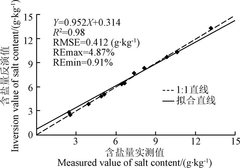
为了验证以(VV2+VH2)/(VV2-VH2)极化组合为自变量建立的研究区土壤含盐量反演模型的精度,利用12个检测样本对应的雷达图像的后向散射系数计算土壤含盐量的反演值。将检验样本含盐量的实测值与反演值一起建立散点图(图4)。图中显示:利用反演模型获得的研究区表层土壤含盐量的反演值与实测值极为接近,检验样本含盐量的反演值与实测值最小相对误差为0.91%,最大相对误差为4.87%;研究区土壤含盐量的反演值与实测值较均匀的分布于1:1直线两侧,其决定系数R达到0.98,均方根误差RMSE=0.412,说明本文采用的土壤含盐量反演方法适用于研究区土壤含盐量的反演,并获得了较好的预测效果。

图4 土壤含盐量反演值与实测值比较
3 讨 论
利用双极化雷达Sentinel-1影像数据进行土壤含盐量的估测研究前人尚未开展。本文试验以(VV2+VH2)/ (VV2-VH2)极化组合方式作为研究区土壤含盐量提取指数,建立了研究区土壤含盐量的反演模型。
本文为了获得较精确的结果采取以下措施:1)为了获得研究区未受植被、冰雪影响的地表地物后向散射系数,本文选择2015年6月14日成像的Sentinel-1 SAR数据(该时刻研究区地表无冰冻与冰雪,绿色植被较少);2)在土壤采样过程中,采样点均匀分布于研究区,能够代表研究区内土壤含盐量的空间分布特征,且建模样本和检验样本均包含盐碱化土壤的所有类型,提高了反演模型的精度与适用性;3)为消除(削弱)遥感影像在成像过程中大气水汽、尘埃等对成像的吸收与散射影响,将Sentinel-1 SAR影像进行辐射校正,获得了较真实的地表地物的后向散射系数,提高了反演模型的精度与稳定性;4)将Sentinel-1 SAR影像的2个波段进行适当组合,以消除影像中噪声的影响,并选择(VV2+VH2)/(VV2-VH2)极化组合建立研究区土壤含盐量的反演模型,以获得较高的反演精度。
然而,利用反演模型获得的检验样本含盐量的反演值与实测值仍然存在一定误差,其主要原因:1)Sentinel-1 SAR影像的成像时间与研究区土壤采样时间仍存在一定差异,对反演模型的精度必将造成一定影响,在条件允许时可选择与采样时间同步的影像数据以提高模型的反演精度;2)国内外一些学者的研究结果显示,雷达影像在表现地表地物信息时,在一定程度上将受到土壤中水分的影响[30-31]。而本文未能有效分析土壤中水分对含盐量反演精度的影响,在今后的研究中需予以考虑,使研究内容得以完善。
本文建立的反演模型是针对于松嫩平原建立的,具有一定的地域性限制,是否适合其他地区还需验证。本文使用的Sentinel-1 IW影像幅宽达250 km,重访周期为12 d,可以实现短时间内对大区域土地盐碱化的时空分布监测,达到了省时省力省费用的目的。
4 结 论
本文试验利用Sentinel-1双极化雷达数据反演大庆市中南部地区土壤含盐量,并获得以下结论:
1)多极化雷达影像的不同极化组合有助于区分不同含盐量的盐碱化土壤,而Sentinel-1雷达极化组合(VV2+VH2)/(VV2-VH2)适用于与松嫩平原盐碱土区时相一致的影像数据,可作为研究区土壤含盐量的指示器。
2)通过建模样本建立起来的土壤含盐量反演模型可以很好的实现研究区土壤含盐量的预测工作,模型的决定系数2达到了0.872,均方根误差RMSE=0.988,检测样本含盐量的反演值与实测值相对误差均较小,表明该模型具有较高的反演精度。
3)土壤含盐量的反演结果表明,研究区内轻度盐碱化主要分布于大庆市南部、大同区东部与北部,中度盐碱化、重度盐碱化主要分布于研究区中部与西部,河流与湖沼周围分布较集中。
[1] 屈永华,段小亮,高鸿永,等. 内蒙古河套灌区土壤盐分光谱定量分析研究[J]. 光谱学与光谱分析,2009,29(5):1362-1366.
Qu Yonghua, Duan Xiaoliang, Gao Hongyong, et al. Quantitative retrieval of soil salinity using hyperspectral data in the region of inner Mongolia Hetao Irrigation district[J]. Pectroscopy and Spectral Analysis, 2009, 29(5): 1362-1366. (in Chinese with English abstract)
[2] 刘全明,成秋明,王学,等. 河套灌区土壤盐渍化微波雷达反演[J]. 农业工程学报,2016,32(16):109-114.
Liu Quanming, Cheng Qiuming, Wang Xue, et al. Soil salinity inversion in Hetao Irrigation district using microwave radar[J]. Transactions of the Chinese Society of Agricultural Engineering (Transactions of the CSAE), 2016, 32(16): 109-114. (in Chinese with English abstract)
[3] 孙永猛,丁建丽,瞿娟,等. 应用电磁感应和遥感的新疆绿洲区域尺度盐渍土识别[J]. 农业工程学报,2012,28(20):180-187.
Sun Yongmeng, Ding Jianli, Qu Juan, et al. Saline soil identification based on electromagnetic induction and remote sensing in Xinjiang Oasis[J]. Transactions of the Chinese Society of Agricultural Engineering (Transactions of the CSAE), 2012, 28(20): 180-187. (in Chinese with English abstract)
[4] 张成雯,唐家奎,于新菊,等. 黄河三角洲土壤含盐量定量遥感反演[J]. 中国科学院研究生院学报,2013,30(2):220-227.
Zhang Chengwen, Tang Jiakui, Yu Xinju, et al. Quantitative retrieval of soil salt content based on remote sensing in the Yellow River delta[J]. Journal of Graduate University of Chinese Academy of Sciences, 2013, 30(2): 220-227. (in Chinese with English abstract)
[5] 姚远,丁建丽,张芳,等. 基于遥感的塔里木盆地北缘绿洲干湿季土地盐渍化监测[J]. 应用生态学报,2013,24(11):3213-3221. Yao Yuan, Ding Jianli, Zhang Fang, et al. Monitoring of soil salinization in Northern Tarim Basin, Xinjiang of China in dry and wetseasons based on remote sensing[J]. Chinese Journal of Applied Ecology, 2013, 24(11): 3213-3221. (in Chinese with English abstract)
[6] 鲁纯. 利用HJ1A- HSI数据定量反演松辽平原土壤含盐量[J].吉林农业大学学报,2013,35(5):577-582.
Lu Chun. Quantitative inversion of salinity based on hyper-spectral data in Songliao Plain[J]. Journal of Jilin Agricultural University, 2013, 35(5): 577-582. (in Chinese with English abstract)
[7] 殷厚民,胡建,王青青,等. 松嫩平原西部盐碱土旱作改良研究进展与展望[J]. 土壤通报,2017,48(1):236-242.
Yin Houmin, Hu Jian, Wang Qingqing, et al. Advance and prospect of the research on improvement by dry farming measures of saline-alkali soils in western Songnen Plain of China[J]. Chinese Journal of Soil Science, 2017, 48(1): 236-242. (in Chinese with English abstract)
[8] 姜洋,李艳,刘东. 基于TM影像属性和形态特征的土地覆被制图方法[J]. 地球信息科学学报,2014,16(1):117-125.
Jiang Yang, Li Yan, Liu Dong. Land cover mapping method based on TM image attribute characteristics and morphological characteristics journal[J]. Geo-information Science, 2014, 16(1): 117-125. (in Chinese with English abstract)
[9] Farifteh J, Vander Meer F, Atzberger C, et al. Quantitative analysis of salt-affected soil reflectance spectra: A comparison of two adaptive methods (PLSR and ANN)[J]. Remote Sensing of Environment, 2007, 110(1): 59-78.
[10] Wang H, Hsieh Y P, Harwell M A, et al. Modeling soil salinity distribution along topographic gradients in tidal salt marshes in Atlantic and Gulf coastal regions[J]. Ecological Modelling, 2007, 201(3/4): 429-439.
[11] 乔木,周生斌,卢磊,等. 近25 a来塔里木盆地灌区土壤盐渍化时空变化特点与改良治理对策[J]. 干旱区地理,2011,34(4):604-613.
Qiao Mu, Zhou Shengbin, Lu Lei, et al. Temporal and spatial changes of soil salinization and improved countermeasures of Tarim Basin Irrigation District in recent 25 a[J]. Arid Land Geography, 2011,34(4): 604-613. (in Chinese with English abstract)
[12] 丁建丽,姚远,王飞. 干旱区土壤盐渍化特征空间建模[J].生态学报,2014,34(16):4620-4631.
Ding Jianli, Yao Yuan, Wang Fei. Detecting soil salinization in arid regions using spectral feature space derived from remote sensing data[J]. Acta Ecologica Sinica, 2014, 34(16): 4620-4631. (in Chinese with English abstract)
[13] 张佩民,张振德,李晓琴,等. 青藏高原荒漠化遥感信息提取及演变分析[J]. 干旱区地理,2006,29(5):710-717.
Zhang Peimin, Zhang Zhende, Li Xiaoqin, et al. Desertification remote sensing information extraction from Qinhai-Tibet Plateau and evolution analysis[J]. Arid Land Geography, 2006, 29(5): 710-717. (in Chinese with English abstract)
[14] 王爽,丁建丽,王璐,等. 基于地表光谱建模的区域土壤盐渍化遥感监测研究[J]. 干旱区地理,2016,39(1):190-198.
Wang Shuang, Ding Jianli, Wang Lu, et al. Remote sensing monitoring of soil salinization based on surface spectral modeling[J]. Arid Land Geography, 2016, 39(1): 190-198. (in Chinese with English abstract)
[15] 王耿明,李达,王忠忠,等. 松辽平原盐碱土含盐量的遥感反演研究[J]. 水土保持研究,2009,16(3):235-237. Wang Gengming, Li Da, Wang Zhongzhong, et al. Research on remote sensing inversion of salt content in saline-alkali soil in Songliao Plain[J]. Research of Soil and Water Conservation, 2009, 16(3): 235-237. (in Chinese with English abstract)
[16] 朱高飞,范燕敏,盛建东,等. 基于HJ1A-HSI超光谱影像的县域耕地土壤盐渍度预测研究[J]. 中国农学通报,2014,30(8):289-294.
Zhu Gaofei, Fan Yanmin, Sheng Jiandong, et al. Estimation of soil salinity in cltivated land at county scale based on HJ1A-HSI hyperspectral image[J]. Chinese Agricultural Science Bulletin, 2014, 30(8): 289-294. (in Chinese with English abstract)
[17] Bindlish R, Barros A P. Parameterization of vegetation backscatter in radar-based, soil moisture estimation[J]. Remote Sensing of Environment, 2001,76(1): 130-137. (in Chinese with English abstract)
[18] Frate D, Schiavon G. Retrieving soil moisture and agricultural variables by microwave radiometry using neural networks[J]. Remote Sensing of Environment, 2003, 84(2): 174-183. (in Chinese with English abstract)
[19] 马红章,柳钦火,闻建光,等. 裸露地表土壤水分的L波段被动微波最佳角度反演算法[J]. 农业工程学报,2010,26(11):24-29.
Ma Hongzhang, Liu Qinhuo, Wen Jianguang, et al. Optimum angle inversion algorithm of bare soil moisture base on L-band passive microwave remote sensing[J]. Transactions of the Chinese Society of Agricultural Engineering (Transactions of the CSAE), 2010, 26(11): 24-29. (in Chinese with English abstract)
[20] 杨魁,杨建兵,江冰茹. Sentinel-1卫星综述[J]. 城市勘测,2015(2):24-27.
Yang Kui, Yang Jianbing, Jiang Bingru. Sentinel-1 satellite overview[J]. Urban Geotechnical Investigation & Surveying, 2015(2): 24-27. (in Chinese with English abstract)
[21] 曾玲方,李霖,万丽华. 基于Sentinel-1卫星SAR数据的洪水淹没范围快速提取[J]. 地理信息世界,2015,22(5):100-107.
Zeng Lingfang, Li Lin, Wan Lihua. SAR-based fast flood mapping using sentinel-1 imagery[J]. Geomatics World, 2015, 22(5): 100-107. (in Chinese with English abstract)
[22] 徐白山,田钢,曾昭发,等. 白城地区盐碱地土壤性质与地质雷达信息应用研究[J]. 水土保持通报,2002,22(4):9-12.
Xu Baishan, Tian Gang, Zeng Zhaofa, et al. Application of GPR information to salinizated soil properties study in Baicheng area of Jilin Province[J]. Bulletin of Soil and Water Conservation, 2002, 22(4): 9-12. (in Chinese with English abstract)
[23] 杨帆,王志春,王云贺,等. 松嫩平原苏打盐渍土土壤水分特征研究[J]. 地理科学,2015,35(3):340-345.
Yang Fan, Wang Zhichun, Wang Yunhe, et al. Soil water characteristic of saline-sodic soil in Songnen Plain[J]. Scientia Geographica Sinica, 2015, 35(3): 340-345. (in Chinese with English abstract)
[24] 马驰. 松嫩平原土地盐碱化研究[J]. 吉林农业大学学报,2014,36(3):333-337.
Ma Chi. Research on soil salinization in Songnen Plain[J]. Journal of Jilin Agricultural University, 2014, 36(3): 333-337. (in Chinese with English abstract)
[25] 祝寿泉,王遵亲. 盐溃土分类原则及其分类系统[J]. 土壤,1989(2):106-109.
Zhu Shouquan, Wang Zunqin. Classification principle and classification system of salt break soil[J]. Soils, 1989(2): 106-109. (in Chinese with English abstract)
[26] 俞仁培. 土壤碱化及其防治[M]. 北京:农业出版社,1984.
[27] 李彪,王耀强. 土壤盐渍化雷达反演模拟研究[J]. 干旱区资源与环境,2015,29(8):180-184.
Li Biao, Wang Yaoqiang. Radar inversion and simulation of salty soil salinization[J]. Journal of Arid Land Resources and Environment, 2015, 29(8): 180-184. (in Chinese with English abstract)
[28] 彭立,杨武年,黄瑾. 川西高原多时相干涉雷达土地覆盖分类研究[J]. 西南大学学报:自然科学版,2016,38(5):125-132.
Peng Li, Yang Wunian, Huang Jin. Study of land cover classification using multi-temporal InSAR data in west plateau of Sichuan[J]. Journal of Southwest University: Natural Science Edition, 2016, 38(5): 125-132. (in Chinese with English abstract)
[29] 依力亚斯江·努尔麦麦提,塔西甫拉提·特依拜,丁建丽,等. 基于多种极化分解方法和全极化合成孔径雷达数据的干旱区盐渍化监测[J]. 农业工程学报,2015,31(23):145-153.
Ilyas Nurmemet, Tashpolat Tiyip, Ding Jianli, et al. Monitoring soil salinization in arid area using Pol SAR data and polarimetric decomposition method[J]. Transactions of the Chinese Society of Agricultural Engineering (Transactions of the CSAE), 2015,31(23): 145-153. (in Chinese with English abstract)
[30] 何连,秦其明,任华忠,等. 利用多时相Sentinel-1 SAR数据反演农田地表土壤水分[J]. 农业工程学报,2016,32(3):144-148.
He Lian, Qin Qiming, Ren Huazhong, et al. Soil moisture retrieval using multi-temporal Sentinel-1 SAR data in agricultural areas[J]. Transactions of the Chinese Society of Agricultural Engineering (Transactions of the CSAE), 2016, 32(3): 144-148. (in Chinese with English abstract)
[31] 游代安,赵少华,史园莉. 一种利用双时相 ASAR 数据监测土壤湿度的方法[J]. 环境与可持续发展,2015,40(6):103-107.
You Dai’an, Zhao Shaohua, Shi Yuanli. A method of soil moisture monitoring with Bi-temporal ASAR imagery[J]. Environment and Sustainable Development, 2015, 40(6): 103-107. (in Chinese with English abstract)
Quantitative retrieval of soil salt content based on Sentinel-1 dual polarization radar image
Ma Chi
(,110122,)
The soil in midwest of Songnen Plain is becoming increasingly more salinized, which highlights the importance of rapid and precise monitoring and evaluation on salinization of soil. With great advantages, the microwave remote sensing becomes an emerging method with huge potential in detecting composition of soil. With the Sentinel-1 image covering the region with salinized soil in Songnen Plain as data source, combined with the assay data of total salt content in the sampled soil from the region of interest, the technology and method of soil salinization information extraction are investigated based on dual polarization radar image. Firstly, 64 soil samples are collected in the study area, and the total salt content of soil samples is tested in the laboratory. Fifty-two soil samples are taken as modeling samples, and 12 samples are taken as test samples. Saline-alkaline soil is divided into light salinization soil (with salt content of 1-3 g/kg), medium salinization soil (with salt content of 3-5 g/kg), heavy salinization soil (with salt content of 5-7 g/kg) and saline-alkaline soil (with salt content > 7 g/kg). The Speckle Filtering of S1TBX software is used to filter Sentinel-1 image to eliminate the influence of noise in the image on information extraction. Radiometric calibration is made for image using Radiometric-Calibrate tool to eliminate the absorption and scattering of atmospheric aerosol for imaging process so as to obtain the true back scattering coefficient of topographical surface feature. The image is subjected to geometrical correction by Terrain Correction tool. Then, by analyzing the quantitative relations between radar image VH and VV polarization modes, back scattering coefficient of polarization combination of VV+VH, VV/VH, (VV+VH)/(VV-VH), and (VV2+VH2)/(VV2-VH2), and soil salt content, the optimized polarization combination mode of the inversion model is determined. Lastly, the prediction model for soil salinity in the region of interest is established using multiple regression technique, and the relative error and root mean square error (RMSE) between predicted value and actual value of salinity in test sample of soil are compared to evaluate the precision of inversion model. The inversion model of soil salinity is used to inverse topsoil salinity in region of interest and the inversion result chart of soil salinity is drawn for the region of interest. The findings are: The back scattering coefficient of Sentinel-1 image VH polarization mode is strongly responsive to medium salinization soil, heavy salinization soil and saline-alkaline soil, and the back scattering coefficient of VV polarization mode is strongly responsive to all degrees of saline-alkaline soil; the back scattering coefficient of polarization mode of (VV2+VH2)/(VV2-VH2) can well separate non-salinized soil, light salinization soil, medium salinization soil, heavy salinization soil and saline-alkaline soil. The coefficient of determination2for the established model reaches 0.872, and the RMSE is 0.988. Model checking results show that, the maximal relative error between predicted value and actual value of sample’s salinity is 4.87%, and the minimum relative error is only 0.91%. In the scatter plot, inverse value and measured value of sample salt content after checking are evenly distributed on both sides of 1:1 straight line, and coefficient of determination2is up to 0.98, and RMSE is 0.412, showing that the inversion model has a high precision in prediction of soil salt content in the research area. The graphical result of the inversion shows that: light salinization soil is widely distributed in the research area; medium salinization soil is mainly distributed in the western and southern Daqing City and western and northern Datong District, and concentrates around the rivers and lakes in the research area; heavy salinization soil, saline-alkaline soil and medium salinization soil are incidentally distributed, and mainly distributed in western and southern Datong District. This method can meet the need for monitoring soil salinization in large region, and provide reference for research on extraction of composition of soil based on Sentinel-1 radar data.
remote sensing; soil; salinity measurement; inversion; Sentinel-1
10.11975/j.issn.1002-6819.2018.02.021
S127; TP79
A
1002-6819(2018)-02-0153-06
2017-08-15
2018-01-07
国家自然科学基金项目(41371332)资助;中国地质调查局项目(1212010911084)资助
马 驰,男,辽宁省义县人,博士,副教授,主要从事RS与GIS应用研究。Email:machi1001@sina.com
马 驰. 基于Sentinel-1双极化雷达影像的土壤含盐量反演[J]. 农业工程学报,2018,34(2):153-158. doi:10.11975/j.issn.1002-6819.2018.02.021 http://www.tcsae.org
Ma Chi. Quantitative retrieval of soil salt content based on Sentinel-1 dual polarization radar image[J]. Transactions of the Chinese Society of Agricultural Engineering (Transactions of the CSAE), 2018, 34(2): 153-158. (in Chinese with English abstract) doi:10.11975/j.issn.1002-6819.2018.02.021 http://www.tcsae.org

