
Groundwater and surface water interactions in an alluvial plain, Tuul River Basin, Ulaanbaatar, Mongolia
2013-10-09 08:10MakiTsujimuraKoichiIkedaTadashiTanakaLuntenJanchivdorjBadamgaravErdenchimegDamdinbazarUnurjargalRamasamyJayakumar
Maki Tsujimura , Koichi Ikeda , Tadashi Tanaka , Lunten Janchivdorj , Badamgarav Erdenchimeg , Damdinbazar Unurjargal , Ramasamy Jayakumar
1. Division of Sustainable Environmental Studies, Faculty of Life and Environmental Sciences, University of Tsukuba, Tsukuba,Ibaraki 305-8572, Japan
2. Institute of Geo-ecology, Mongolian Academy of Sciences, Ulaanbaatar 211238, Mongolia
3. UNESCO Beijing Office, Waijiaogongyu 5-15-3 Jianguomenwai Compound, Beijing 100600, China
1 Introduction
Recently, a decreasing trend has been observed in groundwater levels at some locations in the Tuul River Basin, including the capital city of Mongolia, Ulaanbaatar.However, this trend has not been observed with precipitation which has not presented a clear decreasing trend (Davaa,2008), although the frequency of rainfall from heavy storms appears to be increasing (Oyunbaatar, 2008). Considering these facts, anthropogenic impacts (i.e., huge water demand in urban areas) as well as changes to the process of groundwater recharge may be responsible for causing the decrease in groundwater levels.
Unfortunately, at present, there are insufficient facilities available for groundwater monitoring in Mongolia (Tsujimuraet al., 2007). The Government of Mongolia has recently started plans to establish groundwater and glacier monitoring networks across the country.
Daily water consumption in Ulaanbaatar is 160,000 m3with an average consumption of 200–250 L per person,while average consumption in suburban areas of Ulaanbaatar is only 8–10 L per person. Due to an increase in population and economic development, and despite the efforts made by the Municipality, the present water supply capacity is insufficient to meet the rapidly increasing demand, particularly since more than 50% of the water supplies for Ulaanbaatar are sourced from groundwater aquifers.
Monitoring is important and essential for any scientific study, even if such studies may not be carried out for a number of years; there is still a need to start collecting data.While it may be difficult to define or generalize the data required for a particular study, the availability of adequate data is the key for obtaining successful scientific results.
While groundwater monitoring is important, it is also necessary to monitor surface water as a key source of groundwater recharge. In arid and semi-arid regions, there is an observed local variability in recharge, with rates up to 720 mm/a resulting from ephemeral streams, lakes and preferential flow through fractured rocks in arid and semi-arid regions. Over a larger area, average recharge rates range from 0.2 to 35 mm/a (Scanlonet al., 2006).
Pumping wells for the distribution of drinking water in Ulaanbaatar are located in an alluvial plain of the Tuul River Basin, and it is assumed that groundwater aquifers in this area would be recharged by water from the Tuul River. However, the interaction between surface water and groundwater in this area has not been investigated; rather studies have focused on the hydrological processes in the basin (Jadambaa, 2002; Jadambaa and Buyanhishig,2008).
Considering these issues, the present study aims to define the role of the Tuul River in groundwater recharge by using a hydrological and multi-tracers approach in the alluvial plain of the Tuul River Basin. In particular, the study evaluates the contribution ratio of the river to groundwater recharge using End Members Mixing Analysis (EMMA).
2 Study area and methods
Hydrological observation and water sampling were performed in Ulaanbaatar and the alluvial plain of the Tuul River Basin, including its tributaries. Ulaanbaatar is located at latitude of 47°55'N and longitude of 106°55'E, covering an area of 1,359 km2, with an elevation ranging from 1,300 m a.s.l. to 1,350 m a.s.l. Average annual precipitation in Ulaanbaatar is 257.7 mm and annual average temperature is-0.1 °C, ranging from -23.0 °C in January to +20.0 °C in July. Ulaanbaatar is home to 772,000 people, accounting for 32% of the population of Mongolia. According to national statistics, approximately 60% of the population of Mongolia is classified as urban and more than half of the urban population lives in Ulaanbaatar (JICA, 1994; Batima and Dagvadorj, 2000; Sugitaet al., 2007).
The Tuul River is 704 km long in total with a catchment area of 49,840 km2, with an elevation ranging from 1,200 m a.s.l. to 2,700 m a.s.l. The river drains into one of the main tributaries of the Selenge River, which finally discharges into Lake Baikal, Russia. The Tuul River flows from east to west and the flood plain is located on the northern side of the river (Figure 1). The central area of Ulaanbaatar extends along the alluvial plain which is located on the right bank of the river.
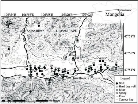
Figure 1 Study area and observation sites
The alluvial plain of the Tuul River in the area of Ulaanbaatar is underlain by two aquifers, the first aquifer consists of gravel and sand with a depth of 10 m and the second aquifer consists of sand and sandy loam with a depth of approximately 30 m (Figure 2). Approximately 40 pumping wells for water supply are located in the central area of the alluvial plain near Ulaanbaatar, with depths of 20 m to 30 m within the second aquifer (Janchivdorj and Erdenchimeg, 2008).
Groundwater table depths at the pumping wells were observed in the beginning of August, 2009 and at the end of August, 2010. Water temperature, electrical conductivity, pH,oxidization reduction potential were also measured during these observations and groundwater, river and spring waters were sampled at the sites during these periods. Inorganic constituent concentrations of Na+, K+, Ca2+, Mg2+, Cl-,HCO3-, NO3-, SO42-, SiO2and stable isotopic composition of deuterium (D) and oxygen-18 (18O) were analyzed on all water samples in the laboratory at the University of Tsukuba.Solubility was analyzed by ion chromatograph (Shimadzu Co., HIC-10A Super) and ICP Atomic Emission Spectrometer (Nippon Jarrell-Ash Co., Ltd., ICAP-757v). Deuterium and oxygen-18 isotopic ratio was analyzed by a Mass Spectrometer (Thermo Fisher Scientific K.K., MAT 252).
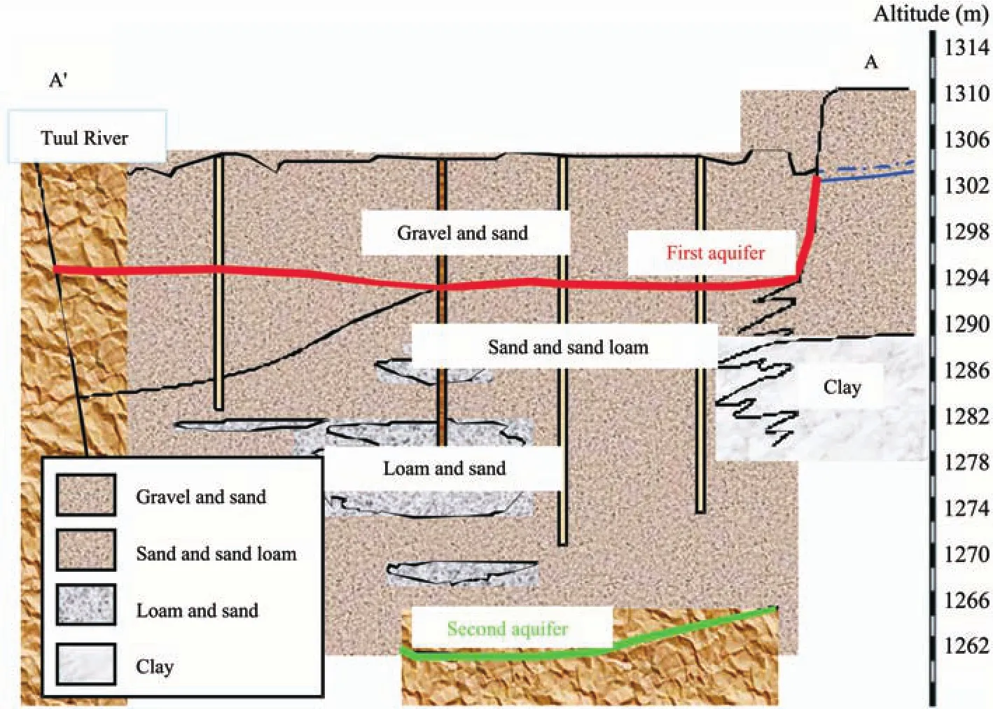
Figure 2 Hydrogeological setting of alluvial deposits of the Tuul River (revised by Janchivdorj and Erdenchimeg, 2008)
3 Groundwater level and flow dynamics
A contour map of the groundwater table observed during pumping in 2009 and 2010 is presented in Figure 3.Groundwater level in 2010 was 0.6 m higher on average than in 2009. The groundwater flows from southeast to northwest, and a north direction component in 2009 was higher than in 2010, especially with an altitude of 1,300 m.The topographical feature of the groundwater table shows that Tuul River water hydraulically recharges the flood plain groundwater. The lower groundwater level caused a higher hydraulic gradient between the Tuul River and groundwater in 2009, leading to a higher groundwater flow component from the river.
Considering the groundwater level observed in 1978 and 1993 (JICA, 1994), groundwater level in 2009 and 2010 was approximately 1 m to 5 m lower than in 1978 and 1993.Therefore, it can be assumed that Tuul River recharge rate became higher in 2009 and 2010 than in 1978 and 1993 due to a change in the hydraulic gradient.
4 Chemical and isotopic characteristics in water
The spatial distribution of solute concentration and isotopic ratios are presented in Figure 4. Water chemical composition is characterized by Ca(HCO3)2type, with a few exceptions. Solute concentrations in the river water were lower than those of groundwater and spring water,although chemical characteristics in the groundwater in the vicinity were similar to those of river water. In addition,ion concentrations of spring water and groundwater in the northern tributaries were higher than those of river water,whereas solute concentrations of water in the southern tributaries were not as high as compared with those of the river. Isotopic ratio of18O was the lowest in floodplain groundwater and river water. The δ-diagram shows (Figure 5) that δ18O of floodplain groundwater was close to that of the river, whereas some values were lower than that of the river. Considering18O and D precipitation compositions around Ulaanbaatar and an altitude effect of18O in river water of Mongolia, winter season precipitation might cer-tainly contribute to flood plain groundwater, although contribution amount is not large. Davaaet al.(2002) showed that Tuul River water is dominantly occupied by melt runoff of winter precipitation during the spring season. Therefore,winter precipitation might contribute to the groundwater via river runoff during the early spring.
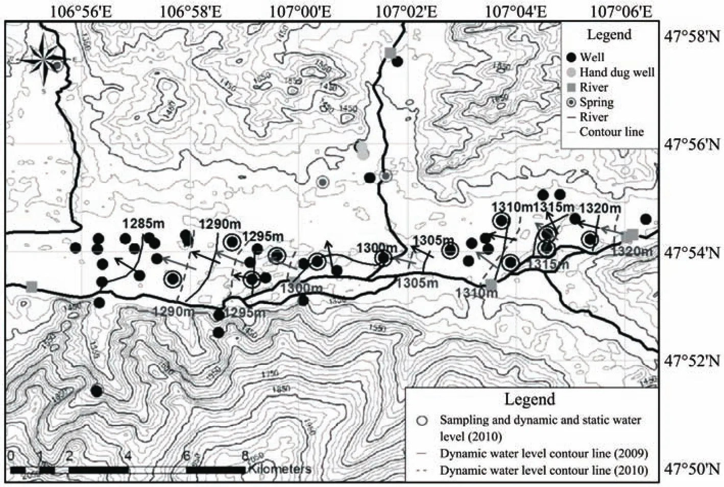
Figure 3 Contour map of groundwater table observed in 2009 and 2010
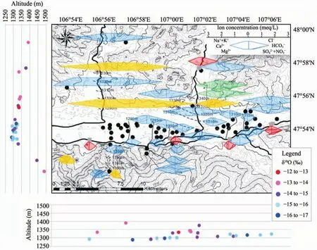
Figure 4 Spatial distribution of solute concentrations and stable isotopic ratio of 18O. Red color in hexa-diagram represents river water, blue color represents groundwater, and yellow color represents spring water
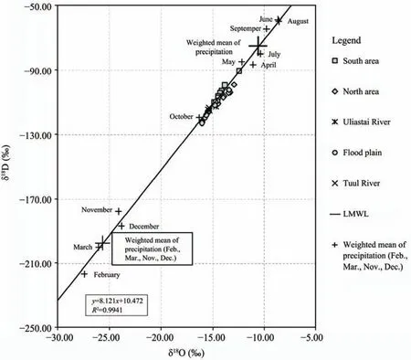
Figure 5 δ-diagram of Tuul River water, groundwater, spring water and precipitation
5 Source of flood plain groundwater
Considering18O value as a conservative tracer, SiO2and HCO3-as tracers for relative residence time, three water components were chosen as sources of flood plain groundwater of Tuul River water for an End Members Mixing Analysis as follows (Figure 6): (1) groundwater of well No.51 along the Uliastai River as representative of the north-side mountain, (2) groundwater of well No. 58 as representative of the south-side mountain, and (3) volume weighted mean of winter season precipitation (November to February).
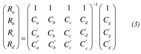
GivenCas concentration of the tracer andRas relative contribution ratio of end members,CandRare presented by the following as:

and Equation(1)is transformed into Equation(2). Subscriptgdenotes floodplain groundwater.

We can obtain a relative contribution ratio of each end member using Equation(2). When there are possible four end members and three tracers, the contribution ratios of end membersatodare computed asRatoRdas Equation(3).
The contribution ratio of the Tuul River, north mountain groundwater, south mountain groundwater, and winter precipitation to flood plain groundwater are evaluated to be 44% to 94%, 1% to 54%, 0% to 16% and 0% to 12%, respectively. The spatial distribution of the contribution ratio of each end member is presented in Figure 7. Overall, Tuul River water contributes dominantly to flood plain groundwater. The contribution of the north mountain groundwater is predominant at site No. 27, this is because the Uliastai River tributary joins the Tuul River around this location and the groundwater component in the north mountain appears to be transformed along the tributary valley (Figure 7).
The role of winter precipitation is not negligible. The shallow soil layer is generally frozen during the winter season in Ulaanbaatar, thus it is not possible for precipitation to infiltrate into the ground. Davaaet al.(2006)showed that Tuul River runoff included a certain amount of winter precipitation during snow and ice melt runoff events in the beginning of spring season. The winter precipitation component appears to be contributing to the groundwater through the Tuul River runoff in the snow and ice melting season.
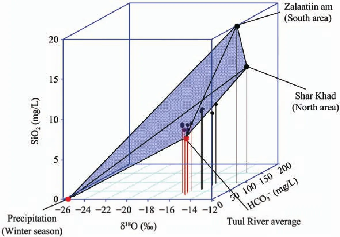
Figure 6 The relationship among δ18O, SiO2 and HCO3- concentrations in the water and each end member
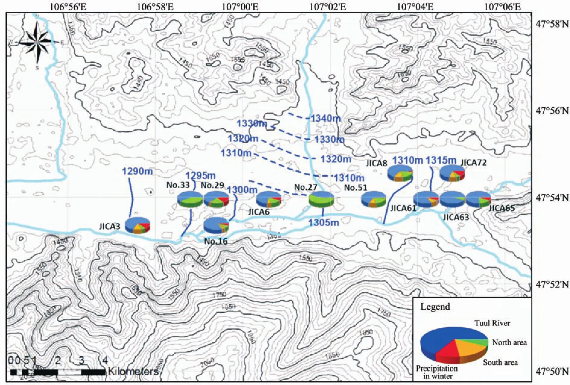
Figure 7 The contribution ratio of Tuul River water, north mountain groundwater, south mountain groundwater,and winter precipitation to flood plain groundwater
6 Conclusions
The origin of groundwater recharge in the Tuul River Basin near Ulaanbaatar, the capital of Mongolia was investigated in this paper. Given the dependence of groundwater for urban water supplies in Ulaanbaatar, a comprehensive understanding of the source of this groundwater is essential for the sustainable management of city water resources.
The contour map of the flood plain groundwater table surrounding Ulaanbaatar indicates that recharge of this groundwater was predominately from the Tuul River. Also,chemical and isotopic characteristics of river water and groundwater suggest a dominant interaction between the Tuul River and groundwater.
An End Member Mixing Analysis was applied to evaluate the relative contribution of river water to groundwater.The contribution ratio of the Tuul River, north mountain groundwater, south mountain groundwater and winter precipitation to flood plain groundwater was estimated to be 44% to 94%, 1% to 54%, 0% to 16% and 0% to 12%, respectively. From this study, it is clear that the Tuul River is the dominant contributing source to groundwater aquifers and groundwater level is sensitive to river water in the flood plains surrounding Ulaanbaatar. In order to maintain water supplies for the city of Ulaanbaatar, preserving and protecting the quality and quantity of the Tuul River will be of paramount importance.
The authors would like to thank Dr. J. Tsogtbaatar, Director,Institute of Geo-ecology, Mongolian Academy of Sciences,Prof. N. Jadambaa, Prof. D. Basandorj, Mongolian University of Science and Technology, Dr. G. Davaa, Dr. D. Oyunbaatar, Institute of Meteorology and Hydrology, Mongolia for their useful comments and suggestions. This research project was conducted as part of the UNESCO-Chair on Sustainable Groundwater Management in Mongolia, and financially supported by UNESCO/Japan Funds-in-Trust Co-operation for the Promotion of International Cooperation and Mutual Understanding.
Batima P, Dagvadorj D, 2000. Climate change and its impacts in mongolia.In: National Agency for Meteorology. Hydrology and Environmental Monitoring and JEMR Publishing, Ulaanbaatar, Mongolia, pp. 227.
Davaa G, 2008. Surface water resources in Mongolia. In: Final Report of University Student Exchange Programme "For the Sustainable Groundwater Resources Management: Through the UNESCO Chair in Mongolia". International Exchange Programme between Japan and Other UNESCO Member States for the Promotion of International Cooperation and Mutual Understanding, University of Tsukuba, Tsukuba, Japan, pp. 81–88.
Davaa G, Oyunbaatar D, Froehlich K, 2002. Interaction of ground and surface waters revealed by stable isotopes in the Tuul River Basin,Mongolia. Proceedings of the International Workshop on Terrestrial Change in Mongolia, Tokyo, Japan, pp. 1–4.
Davaa G, Oyunbaatar D, Sugita M, 2006. Surface water in Mongolia. In:Handbook of Environment Conservation in Mongolia. National Museum of Ethnology, Osaka, Japan, pp. 42–54.
Jadambaa N, 2002. Ground water of Mongolia. In: White Book of Mongolia, Ulaanbaatar, Mongolia, pp. 199–214.
Jadambaa N, Buyanhishig N, 2008. Groundwater resources in Mongolia.In: Final Report of University Student Exchange Programme "For the Sustainable Groundwater Resources Management: Through the UNESCO Chair in Mongolia". International Exchange Programme between Japan and Other UNESCO Member States for the Promotion of International Cooperation and Mutual Understanding, University of Tsukuba, Tsukuba, Japan, pp. 43–56.
Janchivdorj L, Erdenchimeg B, 2008. Groundwater Resource of the Selenge River Basin. Technical Report 2008. Institute of Geo-ecology,Ulaanbaatar, Mongolia, pp. 14–19.
Japanese International Cooperation Agency (JICA), 1994. The Study on Water Supply System in Ulaanbaatar and Surroundings—Final report.Japanese International Cooperation Agency, Tokyo, Japan, pp. 32.
Oyunbaatar D, 2008. River runoff characteristics in Mongolia. In: Final Report of University Student Exchange Programme "For the Sustainable Groundwater Resources Management: Through the UNESCO Chair in Mongolia". International Exchange Programme between Japan and Other UNESCO Member States for the Promotion of International Cooperation and Mutual Understanding, University of Tsukuba,Tsukuba, Japan, pp. 89–95.
Scanlon BR, Keese KE, Flint AL, Flint LE, Gaye CB, Edmunds WM,Simmers I, 2006. Global synthesis of groundwater recharge in semiarid and arid regions. Hydrological Processes, 20: 3335–3370.
Sugita M, Asanuma J, Tsujimura M, Mariko M, Lu M, Kimura F, Azzaya D, Adyasuren T, 2007. An overview of the rangelands atmosphere–hydrosphere–biosphere interaction study experiment in northeastern Asia (RAISE). Journal of Hydrology, 333: 3–20.
Tsujimura M, Abe M, Tanaka T, Shimada J, Higuchi S, Yamanaka T,Davaa G, Oyunbaatar D, 2007. Stable isotopic and geochemical characteristics of groundwater in Kherlen River Basin, a semi-arid region in eastern Mongolia. Journal of Hydrology, 333: 47–57.
 Sciences in Cold and Arid Regions2013年1期
- Sciences in Cold and Arid Regions的其它文章
- G-WADI––the first decade
- G-WADI PERSIANN-CCS GeoServer for extreme precipitation event monitoring
- Water use efficiency in an arid watershed: a case study
- Wavelet analysis of the hydrological time series of Dalai Lake, Inner Mongolia, China
- Time-series analysis of monthly rainfall data for the Mahanadi River Basin, India
- Precipitation-runoff simulation for a Himalayan River Basin,India using artificial neural network algorithms