
Coping with water scarcity in Kashafroud G-WADI Basin,Iran: climate change or growing demands?
2013-10-09 08:10SedighehTorabiPalatkalehNiloofarSadeghiKobraEstiriMeisamAshouri
Sedigheh Torabi Palatkaleh , Niloofar Sadeghi , Kobra Estiri , Meisam Ashouri
1. Water Engineering, Head of Water Allocation Group, Ministry of Energy, Iran (storabi@wrm.ir)
2. Water Management, Prgramme Officer for Natural Sciences, UNESCO Tehran Cluster Office (n.sadeghi@unesco.org)
3. Water Allocation Group, Ministry of Energy, Iran (kobbeh2003@yahoo.com)
4. Water Allocation Group, Ministry of Energy, Iran (meisam.ashuri@gmail.com)
1 Introduction
The impacts of climate change have touched the lives of many people in different places. In recent years, evidence of climate change has been described using various parameters such as declines in snowfall, changes in seasonal rainfall amounts and patterns, more extreme hydrological events(including floods), irregularities in temperature, long droughts, drying of permanent rivers, and so forth. Although climate change has been mostly addressed at the global level,local factors also play an important role in the occurrence of such events.
Study of 30 main basins in Iran have shown that, in addition to global changes in climatic parameters, over exploitation of water resources to meet the growing demands of residents in these basins has also greatly contributed to significant changes occurring across the basins (Detailed study of 30 watersheds of Iran, Bureau of Water Policy and Allocation, Ministry of Energy of Iran). In many cases, changes in the quality as well as the quantity of water resources, less runoff from the same amount of rainfall, higher salinity in rivers, and declines in groundwater levels are caused by natural climate change as well as anthropogenic activities. It is therefore necessary to distinguish and clarify the roles of the various factors contributing to climate change in order to find appropriate responses to combat or mitigate their impacts.
Kashafroud Basin is the most important sub-basin of the larger Sarakhs Basin located in northeastern Iran.Kashafroud hosts one of the most important megacities in Iran, Mashhad, which has experienced many changes in recent years. Due to the rapid population growth of Mashhad City, including both permanent residents and pilgrimage tourism, this basin now incurs a significantly higher water demand for agricultural production as well as an increasing demand for domestic and industrial uses. Therefore, supplying water to meet all of these demands has become the most important challenge in this basin (Integrated Water Resources Management, Project road map of Kashafroud Basin, Toosab Consulting Engineers, 2005).
Historical changes in the quantity and quality of surface as well as ground water resources in Kashafroud Basin indicate that they are partly due to changing climatic parameters and partly due to changes in land use and increase in water utilizations. In this paper, historical data series of the basin are statistically analyzed and, by model simulations of the basin,the various factors contributing to changes across the basin are identified and their roles are distinguished and measured. Additionally, several proposed managerial measures to mitigate these changes are reviewed and simulated. However, achieving sustainability in the basin will require adopting other measures to mitigate the impacts of climate change, including improved water use efficiency in various sectors, further purification/filtration of wastewaters for wider use in agriculture,and less water loss in the domestic and health sectors.
2 Kashafroud Basin
The Kashafroud Basin is the main sub-basin of the Sarakhs Basin, which spans the conjoined borders of Afghanistan, Iran, and Turkmenistan (Figure 1). Mashhad, the second largest city in Iran, is located in the Kashafroud Basin and has a permanent population of 2.5 million people. Because the city is the site of the holy Shrine of Imam Reza, it also receives more than 10 million pilgrimage tourists annually. Due to these special characteristics and the severe situation of water scarcity, this basin has been listed as one of the G-WADI pilot sites under the UNESCO-IHP program (Integrated Water Resources Management, Project road map of Kashafroud Basin, Toosab Consulting Engineers, 2005).
The Sarakhs Basin extends over an area of 44,165 km2and has a population of 3.9 million people. The population pattern of the Sarakhs Basin is shown in Figure 2 (Integrated Water Resources Management, Project road map of Kashafroud Basin, Toosab Consulting Engineers, 2005).
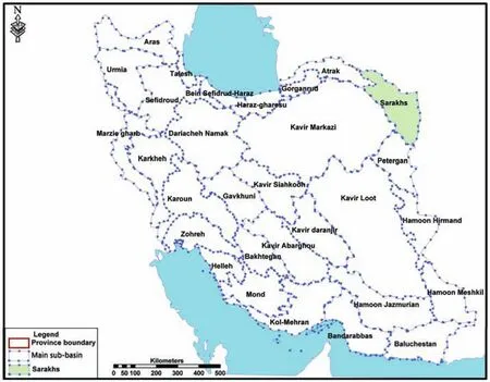
Figure 1 Location of the Sarakhs Basin among other major river basins in Iran
There are 13 aquifers in the Sarakhs Basin, of which only three can be used for extracting groundwater. As shown in Figure 3, in the other 10 aquifers groundwater extraction has exceeded the renewal capacity of the aquifers, so in recent years the Iran Ministry of Energy has denied water extraction from these aquifers.
The most important sub-basin within the Sarakhs Basin is the Kashafroud Basin, with an area of 16,400 km2and a population of 2.5 million people (Figure 4). The mean annual rainfall of the basin is 252 mm. The trend of rainfall rec-orded at the Mashhad weather station, in general, shows a negative trend over time in the average rainfall received in the Kashafroud Basin (Figure 5; Report of Regional Water Authority about Kashafroud Basin, 2010).
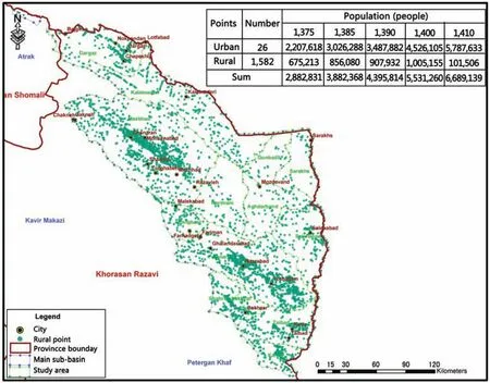
Figure 2 Distribution of population in the Sarakhs Basin
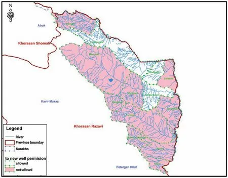
Figure 3 Extraction from groundwater resources in the Sarkahs Basin (pink areas are where extraction from groundwater aquifers is now prohibited)
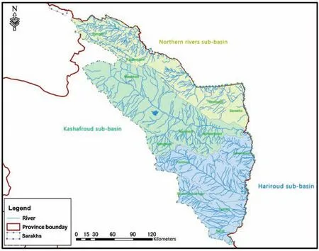
Figure 4 Location of the Kashafroud Basin within the Sarakhs Basin
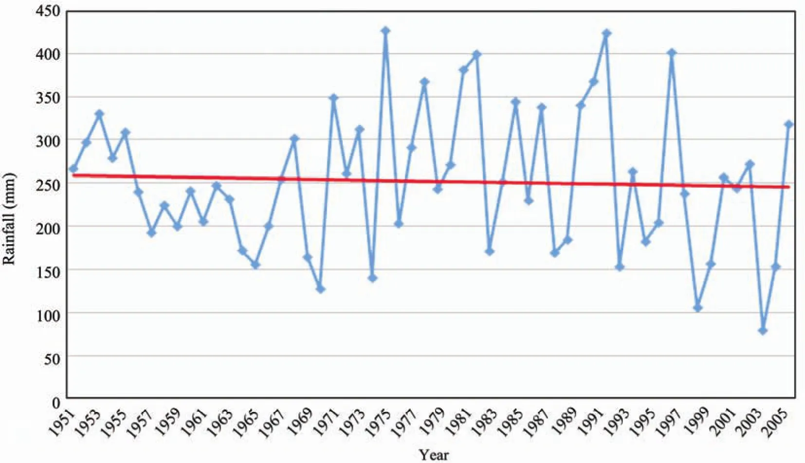
Figure 5 Rainfall data at Mashhad weather station
3 Methodology
To distinguish the impact of natural factors from anthropogenic factors contributing to the water crisis in Kashafroud Basin, a steady-state rainfall period was identified for the basin to replace the naturally negative trend of the basin. This device assumed that once the rainfall has been the same over a certain time period, any change in the availability of water resources is human-caused. In the next step, the available water resources of the basin were calculated, which indicated the trend in availability of water resources as result of anthropogenic interventions.
To estimate the available surface waters, the outflow from the basin at the tail end of the Kashafrud River was added to the amount of surface waters utilized across the basin by means of direct diversion from rivers using electro-pumps, development projects, and regulated waters behind dams. To estimate the outflow from the basin, nine representative hydrometer stations were selected across the basin, as shown in Figure 6. Data from the tail-end station at Pol-Khatoun thus represents the amount water flowing out from the basin which has received all impacts from human activities within the basin.
Once these data were acquired, VENSIM modeling(Ventana Systems, Inc., Harvard, Massachusetts) was used to simulate whether the available water resources could meet the drinking water needs of Mashhad City under various solutions proposed by the local water authority.

Figure 6 Locations of selected representative hydrometer stations in Kashafroud Basin
4 Characteristics of the basin in the steady-state period
4.1 Average rainfall in the steady-state period
Data from 19 rainfall stations were integrated using the Thiessen method to develop a steady-state trend for the rainfall in the Kashafroud Basin over time (Figure 7). The mean annual rainfall of the basin was calculated to be 240 mm, and 247 mm for Mashhad City.
4.2 Available surface water resources in steady-state period
Data from Pol-Khatoun station at the tail end of the basin indicated an average annually available surface water of 68.2 million cubic meters during the steady-state period. However, as shown in Figure 8, there was a sharp drop in this amount between 1956 and 2008, which proves that many anthropogenic activities took place upstream.
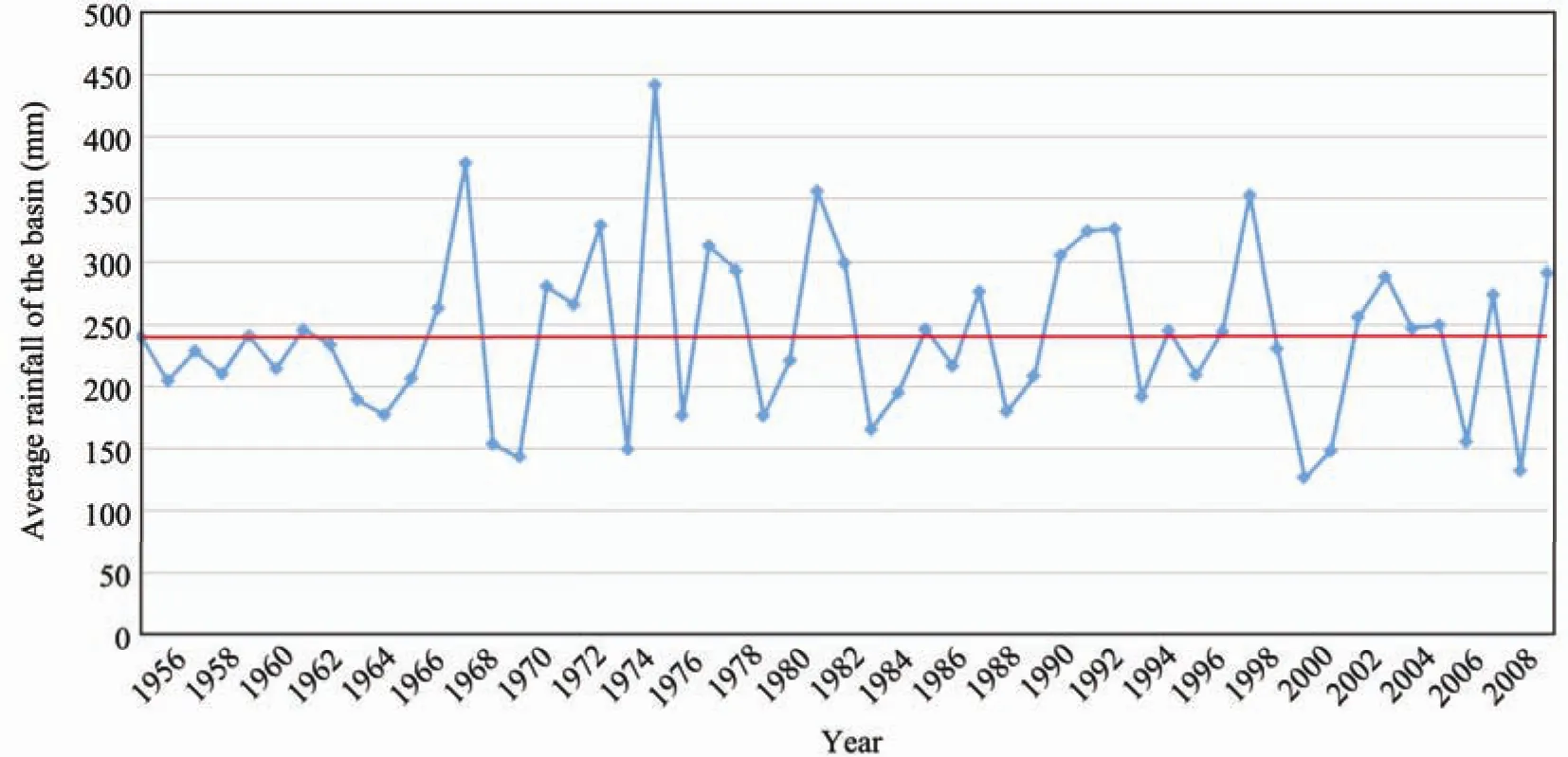
Figure 7 Average rainfall pattern during the steady-state period
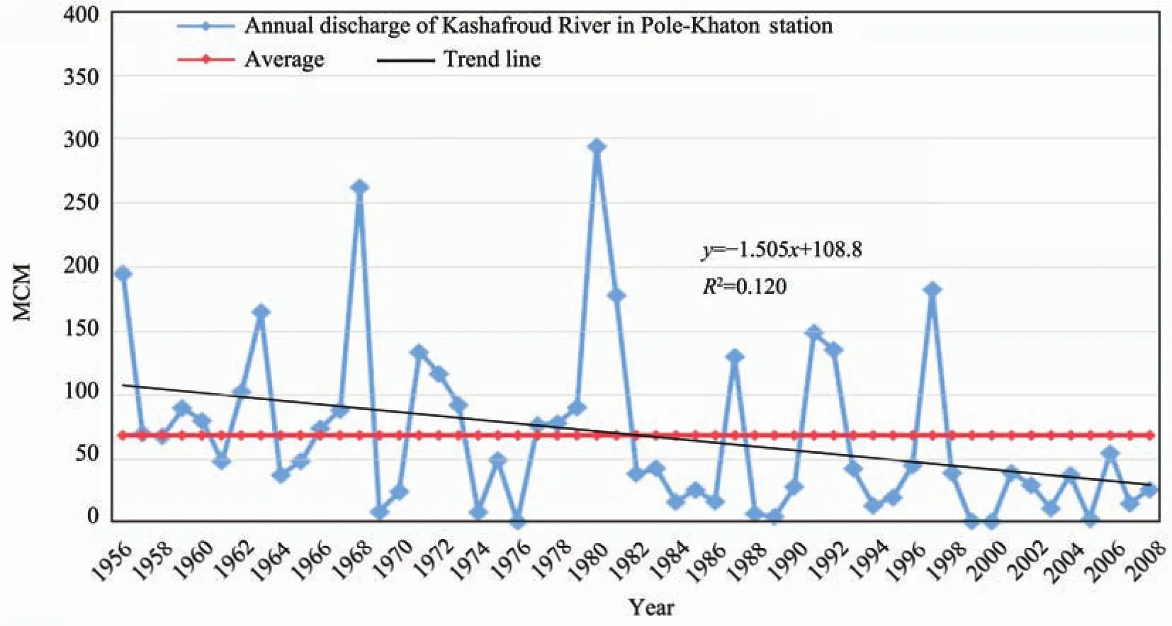
Figure 8 Available surface waters at Pol-Khatoun station during the steady-state period, MCM means million cubic meters
The surface waters consumed over the basin were added to this figure to calculate the total available surface water resources. There are 291 electro-pumps across Kashafroud Basin that divert water directly from rivers, which in total provide 228.5 million cubic meters. Also, there are a number of development projects to supply agricultural, domestic,and industrial water needs, the details of which are shown in Figure 9 and Table 1. With this methodology, the overall available surface water resources were calculated to be 264 million cubic meters.
We also studied the salinity of surface waters by measuring electrical conductivity (EC) at the Pol-Khatoun hydrometer station (Figure 10), which was used later in the simulation of the overall situation of Kashafroud Basin.
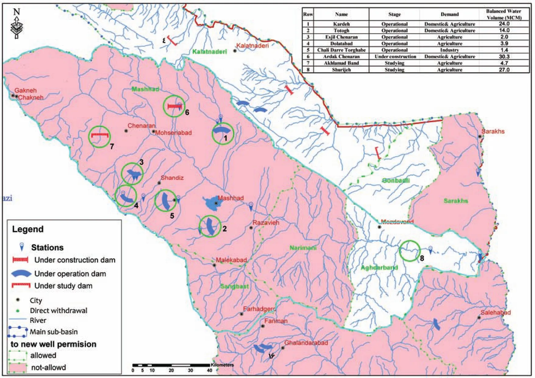
Figure 9 Water development projects in Kashafroud Basin

Table 1 General features of water development projects in Kashafroud Basin
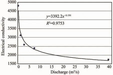
Figure 10 River discharge and EC at Pol-Khatoun station
4.3 Available groundwater resources in the steady-state period
There are four aquifers in Kashafroud Basin, from three of which further extraction has been prohibited due to decline of the groundwater levels. The worst situation in terms of groundwater depletion is in the Mashhad aquifer,which supplies Mashhad City. The second worst is on the Narimani plain, as shown in Figure 11.
The total annual available groundwater resources in Kashafroud Basin are 928.6 million cubic meters, of which 1,133 million cubic meters are consumed per annum. This means that the extra 204.4 million cubic meters extracted from aquifers come from the non-renewal groundwater sources; thus causing severe depletion of the groundwater table. The largest consumer of groundwater resources is the agriculture sector (81.1%), followed by potable domestic use(16%) and industrial purposes (2.9%). Extraction of groundwater resources beyond the renewal capacity of aquifers has resulted in declines of groundwater levels in different parts of the plain, as shown in Figure 12.Groundwater extraction has increased significantly over the last 15 years, to more than 972 million cubic meters while its potential is about 799 million cubic meters (Report of Regional Water Authority about Kashafroud Basin, 2010).
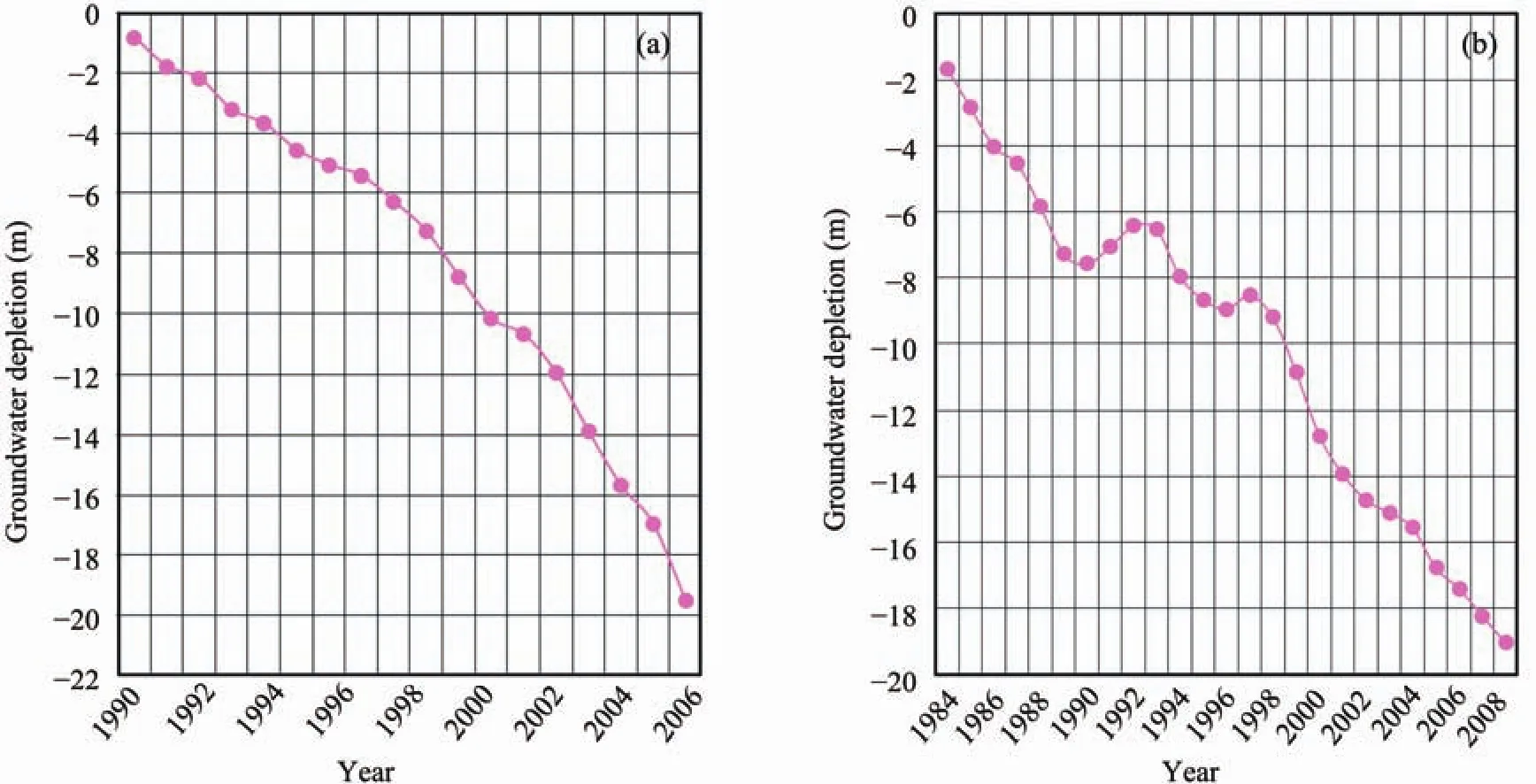
Figure 11 Groundwater depletion in Narimani (a) and Mashhad (b) aquifers

Figure 12 Spatial distribution of groundwater depletion in the Mashhad aquifer over the last 10 years
4.4 Matching the basin’s demands with available water resources
The available water resources of Kashfroud Basin total 1,192 million cubic meters, which includes 264 million cubic meters of surface waters and 928.6 million cubic meters of groundwater resources. However, the total water demand of the basin is calculated to be 1,460 million cubic meters, which indicates that the water needs of the basin exceed its renewal capacity. Although the majority of water resources are used in the agriculture sector, the main challenge in Kashfroud Basin is to supply drinking water to Mashhad City.
Mashhad City has had significant population growth over the past 15 years, resulting in a much higher urban water demand (Figure 13). The water need of Mashhad City at present is 240 million cubic meters per year, which is projected to reach 348 million cubic meters per year in the next 25 years, even under improved water use efficiency (Report of Regional Water Authority about demands of Doosti Dam, 2010).
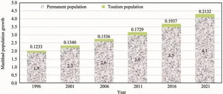
Figure 13 Population growth (both permanent residents and pilgrimage tourists) in Mashhad City, in millions (Integrated Water Resources Management, Project road map of Kashafroud Basin, Toosab Consulting Engineers, 2005)
Currently, 223.5 million cubic meters of the total annual 240-million cubic meters demand of Mashhad City is met by extraction of 194 million cubic meters from the Mashhad aquifer and 29.5 million cubic meters from waters regulated by the Torogh (on the Torogh River), Kardeh (on the Kardeh River) and Ardak (on the Ardak River) dams. Additional extraction from the Mashhad aquifer is now prohibited. The majority of Mashhad City’s water is supplied by groundwater resources (more than 86%); however, as presented in Figure 11, groundwater resources are not reliable and have incurred significant declines over time. It was therefore necessary for the local water authority to propose other solutions for finding reliable sources to meet the growing water needs of Mashhad City, including (Figure 14; Report of Regional Water Authority about demands of Doosti Dam, 2010):
(1) Less extraction of groundwater, to a ceiling of 43 million cubic meters;
(2) Diversion of 29.5 million cubic meters of water from the Torogh, Kardeh, and Ardak Dams to partially meet the needs of Mashhad City;
(3) Construction of a new Shourijeh Dam on the Kashafroud River to supply 24 million cubic meters to meet the long-term needs of Mashhad City;
(4) Replacing water supplied by wells by reuse of urban wastewater to an amount of 80 million cubic meters;
(5) Inter-basin water transfer from the Dousti Dam reservoir to Mashhad City, a total of 150 million cubic meters. This dam is a water development project in the transnational Sarakhs Basin; it is constructed at the border of Iran and Turkmenistan and each country receives a one-half share of the regulated waters (Signed Agreements between Iran and Turkmenistan about Doosti Dam).
These solutions were reviewed at the Bureau of Water Policy and Allocation of the Central Ministry of Energy using VENSIM modeling to simulate Kashafroud Basin once diversions from the Torogh, Kardeh, and Ardak dams have taken place. Construction of the Shourijeh Dam was proven to be theoretically feasible. However according to the result of simulations done by the Water Allocation Commission of the Central Ministry of Energy, this proposal was rejected and water from Dousti Dam is projected to be able to meet the urban water needs of Mashhad City(Reports of Meetings of Water Allocation Commission,special session on water allocation in Kashafroud, Ministry of Energy of Iran, 2011).
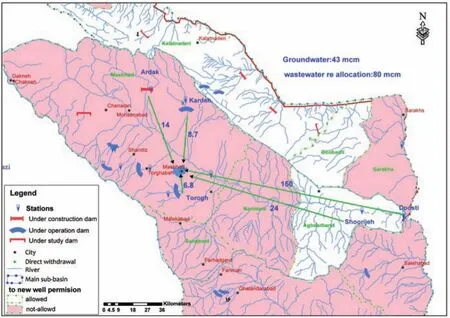
Figure 14 Solutions proposed by the local water authority to meet the urban water needs of Mashhad City
5 Review of solutions proposed for meeting the water needs of Mashhad City
To examine the proposals received from the local water authority for meeting the urban water demand of Mashhad City, two separate models were run by the Bureau of Water Policy and Allocation of the Central Ministry of Energy to simulate Kashafroud Basin as well as the Doosti Dam using the VENSIM modeling.
5.1 Kashafroud Basin
Simulation of Kashafroud Basin involved integrating waters coming from different resources, including total available surface waters, direct diversions from surface waters, water supplied by different development projects,discharge measured at the baseline hydrometer station, and verification of the model using collected data.
The model was also used to examine whether construction of a new Shourijeh Dam can meet its intended purpose. As the first step, the water inflow to dam was calculated using data of hydrometer stations, as shown in Figure 15.
However, because the impact of Ardak Dam upstream of the proposed Shourijeh Dam is not reflected in these data, it was necessary to incorporate the impacts of Ardak Dam on the inflow to the Shourijeh Dam (Figure 16). As seen in Figures 15 and 16, given the present situation, the available water resources of the Shourijeh Dam will decrease from 35 million cubic meters to 26.5 million cubic meters after the impact of Ardak Dam is incorporated. Therefore, construction of a new Shourijeh Dam will not reliably meet the predicted 24 million cubic meters that are needed in addition to the equally distributed monthly rainfall pattern (Reports of Water Commission meetings about water allocation in Kashafroud,Ministry of Energy of Iran, 2011).
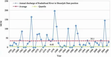
Figure 15 Inflowing water resources (Kashafroud River) to the proposed Shourijeh Dam according to observed data
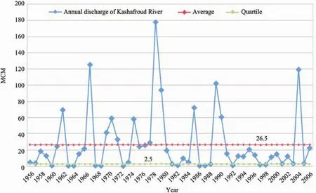
Figure 16 Results of simulation of inflow to the proposed Shourijeh Dam once impacts of the Ardak Dam are incorporated
We also simulated construction of the Shourijeh Dam from other aspects, including the role of the dam in regulating floods as well as securing water for environmental and human needs downstream of the dam. But this new dam still could not be justified in economic terms. Furthermore, we modeled the increased salinity of water downstream of the proposed dam and found significant deterioration of the water quality if that dam was built (Figure 17; Reports of Water Commission meetings about water allocation in Kashafroud, Ministry of Energy of Iran, 2011).
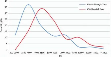
Figure 17 Salinity downstream of the Shourijeh Dam site, with and without construction of the proposed dam
5.2 Dousti Dam (Friendship Dam)
The Dousti Dam (Report of Regional Water Authority about demands of Doosti Dam, 2010 and Signed Agreements between Iran and Turkmenistan about Doosti Dam) is constructed over the Hariroud River at the border of Iran and Turkmenistan, and it addresses several objectives. The Hariroud River originates in Afghanistan, flows along the entire borderline of Iran and Turkmenistan and finally discharge into the Caspian Sea. The specific goals of this dam include transfer of regulated water for supplying drinking water to Mashhad City, meeting the urban and industrial needs in Sarkahs Basin, supplying drinking water to the villages located along the path of the transfer line, supplying some of the drinking and industrial water needs in South Khorasan Province, providing water to the agriculture plains in Sarakhs Basin, and artificial recharge of the aquifers within this basin(Report of Regional Water Authority about demands of Doosti Dam, 2010; Signed Agreements between Iran and Turkmenistan about Doosti Dam).
Our simulation of the dam using different data series showed that the inflow to Dousti Dam is calculated to be 973 million cubic meters (Figure 18). Based on an agreement signed between Iran and Turkmenistan, allocation of regulated water out of the Dousti Dam reservoir follows different computation formulas in different months of the year. These formulas consider the environmental water needs downstream and divide the water equally between the two countries.
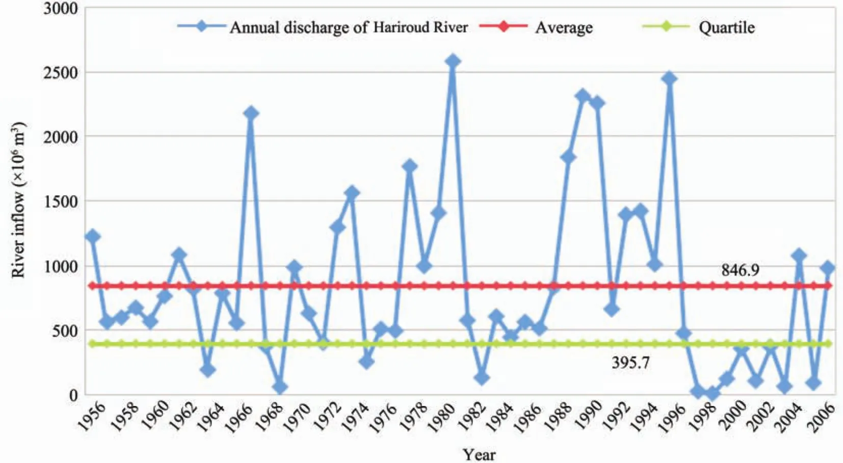
Figure 18 Time series of river inflow to the Dousti Dam
Given that different water demands of the basin are met from different sources, the Water Allocation Commission of the Iran Ministry of Energy prioritized the water needs based on whether they will be met by the Dousti Dam or by other sources, in consultation with various stakeholders. The results of this process and prioritization of needs and resources were incorporated in our simulation model of the Dousti Dam. The model showed that in more than 50% of the scenarios, the transfer line to Mashhad City is fully able to deliver 100% of the needed water, and the average supplied drinking water to Mashhad City is 126.2 million cubic meters annually (Reports of Water Commission meetings about water allocation from Doosti Dam, Ministry of Energy of Iran, 2011).
Additionally, in order to accommodate the risk of droughts and their impact on availability of water resources,the Dousti Dam model was run for different case scenarios,estimating the available water in the reservoir of Dousti Dam at the beginning of each year and the consumption matrix, as summarized in Table 2 (Reports of Water Commission meetings about water allocation from Doosti Dam,Ministry of Energy of Iran, 2011).
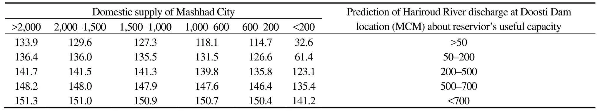
Table 2 Consumption matrix based on the available water in the reservoir of Dousti Dam at the beginning of each year and projection of inflow to the dam in different scenarios
5.3 Reuse of urban wastewater in agriculture
As a measure to combat the water scarcity in the basin,in recent years the local water authority has proposed to reuse urban wastewater for irrigation purposes. Because there will be greater urban water consumption over the coming years, there will be more urban wastewater. As presently reported by the local water authority, Mashhad City produces 80 million cubic meters of wastewater annually, which is projected to reach 250 million cubic meters annually in the next 25 years.
In this context, the local water authority has started small-scale reuse of urban wastewater in agriculture.Although this solution seems to be reasonable, the limitations in purification/filtration of wastewaters to the standard level must also be taken into consideration.Moreover, the risk of hazardous elements and their potential impact on farmers must be rigorously studied. Therefore,further studies and thorough planning are needed before the large-scale implementation of this measure (Report of Regional Water Authority about demands of Doosti Dam,2010).
6 Conclusions
Kashafroud Basin, the most important sub-basin in the larger Sarakhs Basin, was selected for study here because of its critical water scarcity and the clear signs of climate change evident in this basin. Our analysis shows that there has been a considerable reduction in rainfall throughout the basin, and the increasing water demands that have exceeded the renewal capacity of both surface and groundwater resources have introduced significant changes within Kashafroud Basin. However, the water stress caused by human overexploitation of resources has a greater impact compared to the reduced natural precipitation.
The most complex challenge the basin faces is to secure the urban water needs of Mashhad City, the second largest city in Iran. Presently, more than 80% of all water resources are consumed by the agriculture sector. There is no potential for further extraction from groundwater aquifers due to the sharp drop of groundwater levels, at the current rate of 1 m per year. Groundwater resources are already facing major depletion because the current annual extraction of 350 million cubic meters exceeds the renewal capacity of the aquifer systems in the basin. Surface water resources, which are total 264 million cubic meters available in each year, are more or less in a similar situation; construction of six dams in different parts of the basin and direct diversions from rivers have caused only 10% of the normal discharge to be available in the tail end of the basin.
Presently, the majority of water demands of Mashhad City are met by extraction from groundwater resources,which is not a reliable source considering the rapid depletion of the aquifer systems. Today’s urban water demand of Mashhad City is 240 million cubic meters per year, which is predicted to reach 340 million cubic meters per year over the next 25 years.
The local water authority has proposed several solutions to meet the increasing water demands of Mashhad City,including: supplying 29.5 million cubic meters by means of six small dams on the Kashafroud River; reducing groundwater extraction by imposing limitations to a ceiling of 43 million cubic meters annually; supplying 24 million cubic meters by construction of a new Shourijeh Dam on the Kashafroud River; transfering of 150 million cubic meters of water from the Dousti Dam reservoir; and replacing groundwater extraction for agriculture with reuse of urban wastewater.
To examine the feasibility of the solutions proposed above, we ran two separate VENSIM model simulations of Kashafroud Basin: one for the Kashafroud River and the other for the Dousti Dam. The Kashafroud River simulation showed that a new Shourijeh Dam will not be able to meet its objectives and, furthermore, it will cause significant adverse changes in the water quality downstream of the proposed dam. The Dousti Dam simulation showed that transfer of water from this dam’s reservoir can fully meet its required demands in more than 50% of the projected scenarios, and the average amount of water supplied to Mashhad City will be 126.2 million cubic meters annually.Therefore, the local water authority should devise a strategy each year on how to plan for use of released waters from Dousti Dam based on the annual inflow to the dam’s reservoir according to the consumption matrix developed for the dam.
Reuse of urban wastewater in agriculture requires thorough study of the risks of hazardous pollutants harming farmers. In this respect, mechanisms for proper infiltration/purification of the wastewater before delivery to farms, and safety measures which should be followed by farmers, must be developed. For the growing urban water needs, urban wastewater will become a substantial source of water in the next 25 years, which can play an important role in combating water scarcity in the Kashafroud G-WADI Basin.
Ministry of Energy of Iran. Reports of Water Commission meetings about water allocation from Doosti Dam, 2011.
Ministry of Energy of Iran. Reports of Water Commission meetings about water allocation in Kashafroud, 2011.
Report of Regional Water Authority about demands of Doosti Dam, 2010.
Report of Regional Water Authority about Kashafroud Basin, 2010.
Signed Agreements between Iran and Turkmenistan about Doosti Dam.
Toosab Consulting Engineers. Integrated Water Resources Management,Project road map of Kashafroud Basin, 2005.
 Sciences in Cold and Arid Regions2013年1期
- Sciences in Cold and Arid Regions的其它文章
- G-WADI––the first decade
- G-WADI PERSIANN-CCS GeoServer for extreme precipitation event monitoring
- Water use efficiency in an arid watershed: a case study
- Wavelet analysis of the hydrological time series of Dalai Lake, Inner Mongolia, China
- Time-series analysis of monthly rainfall data for the Mahanadi River Basin, India
- Precipitation-runoff simulation for a Himalayan River Basin,India using artificial neural network algorithms