
The traps behind the failure of Malpasset arch dam, France, in 1959
2013-07-10 12:23PierreDuffaut
Pierre Duffaut
ExpertinGeologicalEngineering,France
The traps behind the failure of Malpasset arch dam, France, in 1959
Pierre Duffaut∗
ExpertinGeologicalEngineering,France
A R T I C L E I N F O
Articlehistory:
Received 22 November 2012
Received in revised form 3 May 2013
Accepted 8 May 2013
Dams
Geology
Rock mechanics
State control
Human error
The case of the Malpasset arch dam failure in 1959 has been widely exposed in scientific and technical forums and papers. The focus here is on the many traps which have confused the whole chain of bodies and persons involved, owner, designer, geologist, contractor, up to the state management officers. When the first traps were hidden inside geology, many more appeared, as well geotechnical, technical, fortuitous, and administrative. In addition to such factual factors, human and organizational factors may be today easily identified, when none of them was yet suspected. Both dam safety and rock mechanics benefited from the studies done since the Malpasset case, most of them within one decade.
© 2013 Institute of Rock and Soil Mechanics, Chinese Academy of Sciences. Production and hosting by Elsevier B.V. All rights reserved.
1. Introduction
On 2 December 1959, the failure of Malpasset dam (Fig. 1) was a prominent industrial catastrophe in France within the 20th century, only second by number of victims to a coal dust explosion in Courrières mine 53 years before. It was also a clap of thunder in the world dam community as never before any arch dam had failed, as André Coyne had pointed when opening a symposium on arch dams in 1957 as president of International Commission on Large Dams (ICOLD). It is well known that many more have been built since worldwide, and far higher, without any failure either. Many papers have described the Malpasset case, from the early studies to construction, operation and failure, the expert reports, the trial minutes and many lab and site investigations launched in order to understand what went wrong, ending with five papers published in 2010 inRevueFranc¸aisedeGéotechnique(Carrère, 2010; Duffaut, 2010; Goguel, 2010a, b; Habib, 2010).
No surprise the first traps have been geological ones: for long, igneous and metamorphic rocks had been experienced as impervious enough for reservoirs and strong enough for dam foundations. Here they proved impervious, but failed as foundation. As the author began working in 1948 with EDF, the French authority for Electricity, in the Geology Department, he took part in the studies of many dam sites in France. He is now one of very few living geological engineers (if even anyone worldwide) to have worked in the field of dams at this time, when a great number of sites were investigated, in France and abroad. Neither EDF nor the author had been involved in Malpasset dam before the failure, while they immediately manifested their highest interest in the case. EDF was yet operating many arch dams, and many more were at construction or design stage. To the author, the case may look as a family affair, as his father Joseph Duffaut, had spent his whole career in dams. When Malpasset failed, the author was resident engineer on an arch dam construction site, just completed; his father was the first civil servant sent to the site by the government, the day after, as head of the Dam and Electricity department in the Ministry of Public Works; he then followed all the studies and trial sessions and the author could benefit his early pictures on site as well as his philosophy, “from father to son”. After that his career was turned from Geological Engineering into Rock Mechanics.
One knows that most rare accidents derive from many wrong events together instead of only one; many more traps were to be soon discovered in addition to geological ones: geotechnical tests on site and in lab showed unsuspected and very poor properties; technical rules about uplift were not applied to thin dams! Two fortuitous events at the same time confused the local authorities, a worksite downstream and a flash flood. Last, and the more, no independent state control had ever been done on this public project, neither before nor during construction and operation. Since the mid-20th century, partly under pressure from the most hazardous industries, oil, aerospace, and nuclear activities, non-technical factors of accidents safety have been studied more and more and many scientists pointed that complexity is a hazard in itself: they showedhow the weight of human and organizational factors could be heavier than factual and technical ones. The Malpasset case can bring them one more example.
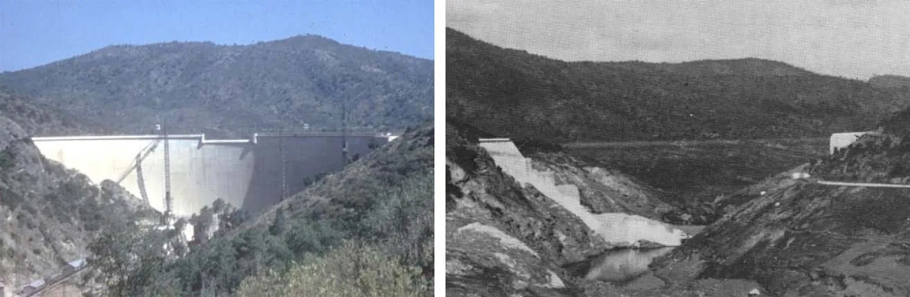
Fig. 1. Malpasset dam, left, at end of construction, summer 1954 (photo COB); right, soon after failure, end 1959 (photo Mary).
The purpose of the paper is to explain how people in charge have been abused by so many traps, while what had been done there up to completion of the dam was correct within the practices of 1950s. So the responsibility of the catastrophe must be shared by many bodies and persons, the last one being a prefect, the local representative of the government, who did not know that a dangerous structure inside his territory was not managed by a competent enough staff. Many dams worldwide have been deeply modified along the years and a few have been put out of service when their responsible manager happened to discover they did not behave as safely as expected. So the memory must be saved of André Coyne and his dam engineering Bureau, (appearing below under acronym COB, Coyne and Bellier), always active today as Tractebel Engineering France, a member of GDF-SUEZ.
2. What happened
About 15 km from Fréjus, an old Roman city on the Côte d’Azur, along Mediterranean Sea, at a place called Malpasset (a bad pass for passing people), a dam had been designed and built in 1950s to provide irrigation and drink water from Reyran, a very small river. Prof. G. Corroy of Marseilles University delivered the geological report, André Coyne and his Bureau COB designed the arch dam (Figs. 2 and 3) and supervised the whole construction works, made by contractor Ballot. None of them kept any mission from the owner after completion, in spite of the dam having never been formally checked; along the first years its filling up was prevented by lack of expropriation of a fluorite mine upstream of the dam, and later this reservoir was left unused as the water distribution network had not been completed. A geodesy company made four yearly measurements on about 30 targets (Fig. 4), but nobody interpreted the results of the year 1959, which had been transferred lately to the owner.
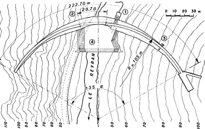
Fig. 2. Site map, contours in meters over sea level (1: bottom gate; 2: surface weir; 3: water intake; 4: stilling basin); at right a gravity thrust block protected from water thrust by a wing wall counteracts the crest arch thrust.

Fig. 3. Highest dam cross section (mosl means meter over sea level). The support of the hollow valve and its control gate explains the widened foundation at this place only. Crest elevation: 102.55 m over sea level; spillway elevation: 100.4 m; normal operation level: 98.5 m; bedrock level: 38 m.
This year it rained a lot in autumn, resulting in the reservoir level increasing over any levels attained before. Contrary to previous years, the bottom gate was not opened to control the levelbecause a motorway bridge was under construction 1 km downstream of the dam and nobody took account of any flow in the river. From November 30 to December 2, the rain intensity was such that the level rose 4.5 m in spite of the reservoir area increasing for each meter more (box in Fig. 4); the “normal” autumn rain had peaked as a sudden flash flood which was close to overflow the weir. In spite of a late opening of the bottom gate, the dam gave off at 23:11 and a huge wave wiped all structures along the valley, up to a small military airport on the seashore, making more than 400 casualties and a lot of destruction including all rail and roadways across the valley.
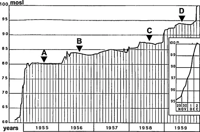
Fig. 4. Graph of the reservoir level along years 1954–1959. The box magnifies the four latest days, and triangles mark the dates of geodesy measurements A–D (after Mary, 1968).
3. The traps
3.1.Geologicaltraps
The gross site of the reservoir was a narrow section through a small gneiss horst across a wide valley carved in coal measures, a rocky tract for easily damming a big reservoir. At first sight, the rock mass of this old metamorphic horst did not appear different from so many dam sites in other parts of France. After the failure, a flow of 50 million cubic meters of water have cleaned the slopes perfectly from any loose or even weathered material, the rock mass structure appeared very heterogeneous and crisscrossed by joints at any scale and in any direction as noticed by prominent geologist Jean Goguel (Goguel, 2010b) who surveyed the whole site soon after the failure. The geological history of the Estérel massif, now better known, may explain this peculiar structure which nobody had expected.
Only the failure daylighted two features of the rock mass which proved instrumental. A huge block of foundation rock was missing where was the left half of the dam arch, leaving an excavation in a dihedral form limited by two subplane faces, always visible now (top of Fig. 5). Its downstream face is a true fault plane with a thin cover of crushed rock (fresh scratches on the surface proved the whole block had moved upwards). Its upstream face looks as a set of tears along two or more foliation surfaces, without any crushed rock. Neither the fault nor the foliation had been recognized before; the contours on Fig. 2 could have helped to infer the position of the fault, but its strike perpendicular to the valley axis and its dip about 45°upstream would have considered it as perfectly neutral with respect to the thrusts received from the dam; the continuity of rock foliation had not appeared either, within the so heterogeneous structure of the gneiss. So a geometrical trap was in place, waiting for a force susceptible to move the block, which will appear later.
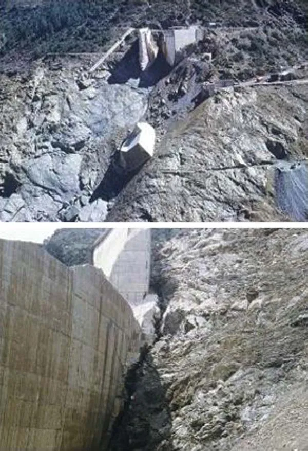
Fig. 5. The most conspicuous features of the site exposed after failure. Top, the“dihedral” excavation with half of the thrust block fallen after the flow (the exploratory adit at right was bored early after the failure to make jack tests in situ); below, a wide crevice is open just upstream of the concrete arch, wider at the base and closing more higher (photos Duffaut, 1960).
One may question why boreholes had not previously located the fault. First, most boreholes investigated the depth to the sound rock, under alluvium in the river bed and under any loose grounds along the valley slopes. Second, it is today difficult to recall that the technology of core recovery was not able to investigate such features. On many dam sites where contour lines accidents suggested a weak zone, their investigation used trenches instead of boreholes. The cleaning action of the flow made the fault path visible on the right bank and daylighted its cross section at either bank toe (Fig. 6).
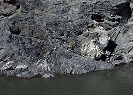
Fig. 6. Close view of a cross section of the main fault on right bank. The finely crushed borders of the fault zone are well visible, thickness about metric (photo Duffaut, 1960).
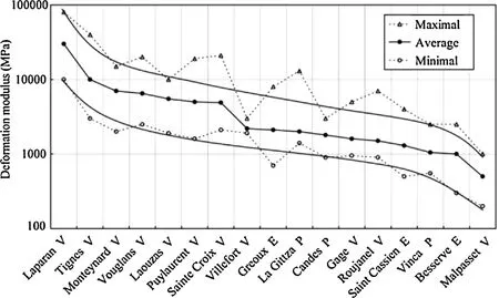
Fig. 7. Deformation modulus measured on 17 dam sites (V: arch; P: concrete gravity; E: rockfill). Modulus scale in MPa, logarithmic; sites classified by decreasing modulus along three curves, maximal, average and minimal values (graph designed by B. Goguel, from EDF data).
At rock matrix scale, some samples (Goguel, 2010b) revealed the rock close to the dihedral contained moresericitethan elsewhere, a mica like mineral susceptible to increase the deformability and decrease the strength. He wrote: “I think . . . the failure is due to the poor mechanical strength of a gneiss which happens to contain dispersed sericite” (this observation was not followed with any tests of strength and deformability, and no rock block from the dihedral has been sampled to check this in fluence). Weathering of the gneiss has been pointed by some experts, but instead of any observation con firming its in fluence; the absence of any slope slide upstream of the dam during the fast drawdown and the perfect state of the roman aqueduct at mid-height proved the global strength of the slopes.
3.2.Geotechnicaltraps
There had been no geotechnical investigations before the construction of the dam. Immediately after the failure, several studies were launched, at first on site, by seismic methods and jack tests, and in laboratories on samples taken from the site.
Refractiontraverses showed a compact rock (velocity over 4000 m/s) below a shallow zone with velocity closer to 2500 m/s.
Petitesismique(Schneider, 1967): A new short range seismic technology, easy to use on site, con firmed the high deformability of the rock in situ, together with the high compactness of the rock mass. The dynamic modulus derived from both deep refraction traverses and shallowPetitesismiquewas around 1500 MPa, a rather low figure for a dam foundation.
Jacktests(Talobre, 1957): EDF sent immediately a team to perform jack tests in a few small pits and galleries purposely bored. As very few such tests on dam sites were available for comparison, EDF ordered same tests be made on seven sites the same year and Malpasset provided by far the weaker results.
Later the practice became usual on most new sites, as shown in Fig. 7 which gathers the results for 17 sites and con firms the very high deformability of the rock mass, ten times less than that on most sites, hundred times less than that on best sites.
Such low deformability was unsuspected and even the Saint Cassien dam site, close to Malpasset on the same rock type had provided results two times more.
Labtests: Rock samples were sent to various labs, mainly École Polytechnique, Palaiseau (LMS, Laboratoire de Mécanique des solides), École des Mines, Paris-Fontainebleau, and École de Géologie,Nancy.The main set of tests results was described and discussed in a thesis work at LMS under supervision of Pierre Habib (Bernaix, 1967).
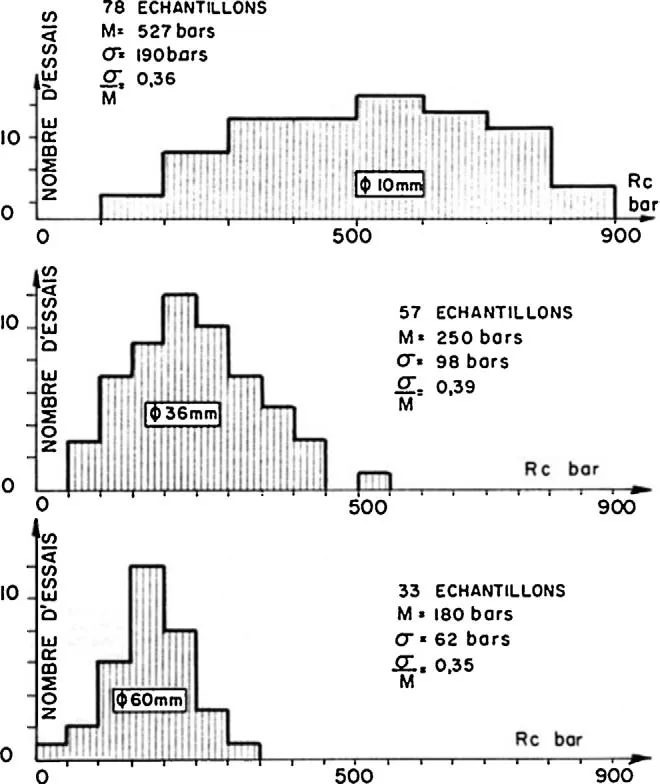
Fig. 8. Distribution of unconfined compressive strength Rcin bar (=0.1 MPa) on dry samples (échantillons) collected on the left bank; three sets of cylinders, diameters 10, 36, and 60 mm (Bernaix, 1967). Comparison between three cases shows the scale effect: maximum strength occurs on smaller cylinders, where scatter also is the highest (vertical axis: number of samples; M: average value; σ: standard deviation).
Standard uniaxial compressive and tensile tests were performed on cylinders with diameters 10–60 mm and the same height to diameter ratio, 2.0. Strength values did not appear too low in average (58 MPa at dry state, and 42.5 MPa at saturated), but theirscatterappeared by far wider than usual (coefficient of variation about 0.36), so providing many spots with high deformability. Taking various dimensions, a high scale effect was detected, as seen in Fig. 8. Systematic studies on various rock types showed that scatter and scale effect went together and provided a reliable fracturation criteria.
Actually, all types of classical lab tests were performed, and one more: the permeability being very low, Habib (2010) proposed a new type of test to make measurements without any risk of error due to leaks along the envelope of the sample; thanks to a coaxial hole in the rock cylinder, a radial flow is generated from or to the hole depending if the fluid pressure is applied around or inside. When the flow is centrifuge, the rock is set in a tensile state which makes the permeability increase with the pressure, whatever the rock type; conversely a flow toward the hole creates a compressive state which does not alter the permeability of most rock types; but all samples from Malpasset showed a high sensitivity of the permeability, the more on the left bank: though rather low, the permeability decreased a lot under compression, due to closure of minute cracks. Not any other rock displayed such a behavior.
This unsuspected property, high sensitivity to stress, was then supposed to be the main cause of failure, as the load applied by the dam on the foundation rock induced a deep “underground dam” against which the uplift pressure could build more and more. Here was the force to move the dihedral. Actually, the highdeformability was susceptible to play the same role: when the dam moves downstream under the water thrust, the rock upstream does not follow and a crack opens between the concrete and the rock as seen in Fig. 5 (below). The more deformable the rock mass is, the wider the crack opens, the deeper it extends, so increasing the height of the dam with a hydrostatic thrust increasing as the square of the height. Whichever mechanism prevails, the force on the dihedral is the same.
The anisotropy of the rock mass may provide another more mechanism: Maury (1970) investigated the stress bulb under a foundation which becomes thinner and deeper when the thrust is perpendicular to the strati fication or schistosity; this in fluence was not well known at the time.
3.3.Technicaltraps
After the failure of Bouzey small gravity dam (eastern France), Lévy (1895) showed that pressure from water seeping below and inside a structure plays as Archimede’s thrust on buoying vessels and named itsous-pression(uplift). Most gravity dams were since preserved from it by relief holes; a so-called “drainage curtain”became a corollary of classical tightness curtains, but thin dams were thought immune thanks to the smaller area of their base. Malpasset opened the eyes of dam designers on uplift acting not only below and inside the structure, but also inside the rock mass downstream.
It became clear that any dam is a gravity dam, contrary to the usual classi fication of dams (Duffaut, 1992) provided enough ground mass be included in the gross resistant weight against the water thrust.
3.4.Incidentaltraps
Moneyin flation: In 1950s, the money in France (and in many more Europe states) was in flating at a high rate. The sum allowed for the project was fixed, the owner was pressed to see the job finished in order to avoid the cost rise and he did not follow a recommendation of the geologist to make some more investigations. This monetary trap has been focused by Jean Goguel at the trial (Goguel, 2010a).
Bridgeworksite: In 1959, a motorway was to be built from Aixen-Provence to Nice which had to cross the Reyran river about 1 km downstream of the dam: earthworks had begun during summer months and the bridge worksite was glad to bene fit a zero discharge in the river thanks to the dam; so the gate was kept close and the level rose higher than ever before, without any extra test or survey.
Flashflood: At the end of November, a flash flood occurred and the level rose dramatically (box in Fig. 4). One may notice such floods had been neglected from the design stage.
Geodesycontract: One could add the late delivery of the August 1959 measurements: the director of the company in charge of them was called to the trial for having delayed their delivery: he argued the length of calculations plus the summer vacations of his staff. Formally his contract did not ask for any interpretation or comparison with previous results. When the owner received the results (Fig. 9), nobody had paid attention and they were forwarded to the prefect to be included in the dam files.
Cracksinthestillingbasin: No report was produced which confirmed the date, the location and the importance of appeared cracks a few days before the catastrophe in the reinforced concrete of the stilling basin without any schemes and photographs. One wonders that the guard was not specially auditioned on a material element susceptible to alert the staff in charge, at any level, on a disorder susceptible to be a sign of imminent danger. This element re flects the importance that each member of an organization is aware of its role in the safety of operation. If it is not an unfounded rumor, it is a grave failure of the organization, maybe a grave fault of the guard. At least, the concern of the staff in charge had led them to summon Coyne (and Ballot) at a close date, which has proved too late.

Fig. 9. Displacements of the targets along arches at elevation 78 and 90 m (after Mary, 1968); bold letters refer to measurement dates (Fig. 4); other letters name the construction joints between monoliths; the scale applies to target displacements: segments CD, between measurements 1958–1959, show a general move toward the left bank, a fact any professional could have noticed as a change of behavior, long before the latest 5 m rise.
3.5.Statemanagementtraps
The Vardépartement, an administrative level of the State, was the owner, deprived of any dam specialist. It relied on the Engineer for design and for construction supervision but did not asked for any more mission after the end of construction; the formalréception(commissioning) did not wait for any test at full level, as was usual but not mandatory, by lack of water and because the property rights of the whole reservoir area had not been bought; the prefect signed it in order to permit full payment of contractors without asking the owner to perform any more surveys.
4. Human and organizational factors
Lack of dialog with more than two persons (the Geologist sent reports but did not meet the Engineer on site). In France, Coyne used to work with EDF, a national company with many experimented engineers, and under permanent supervision of a corps of well trained state engineers. Neither EDF nor this corps were involved in Malpasset.
One may wonder administrative borders be tight against technical information exchange: along the same years a bigger arch dam, Bimont, was being built within 100 km of Malpasset for drink water of Marseilles under the nextdépartementBouches-du-Rhôneas owner, but not any link appeared between the teams in charge of those dams in spite of both the geologist and the engineer being the same.
And the more one must notice the lack of any control by a third party (which was soon created and made mandatory for all dams over 15 m height).
5. Other catastrophes
Many comparisons may be made with a series of catastrophes within the 20th century and up to now:
(1) coal-dust explosion in the Courrières mine in France in 1906, when nobody could think a coal-dust explosion could reach so far;
(2) drowning of the British liner Titanic in 1912 after collision with an iceberg: from the of ficers and all passengers on board, to the general public worldwide, the liner was thought of as nonsubmersible and the staff denied the cables received about the drift of icebergs;
(3) explosion of the English dirigible R101 (1930, near Beauvais, France) during its inaugural flight, operated before completion of the convincing steps of the experimental stage, to ful fill political ambitions: a fault shared with Malpasset and Vajont (see below);
(4) deadly Aberfan debris flow in South Wales in 1966: in spite of many small shallow slides on sterile coal mine heaps, the height has been increased higher than experienced before (Duffaut, 1982);
(5) explosion of the American Space Shuttle Challenger (1986) after many warnings about failed joints in the solid rocket booster and the decision to maintain the launch to meet political requirements of NASA (aimed to obtaining next budgets);
(6) crash of flight AF447 (offshore Brasil, 2009), the staff of which was caught in a tropical tempest and deprived from data from frozen Pitot tubes;
(7) Fukushima tsunami induced nuclear accident (2011, Japan), where the local staff was left without any means of action when both water cooling of the reactors and electric power were put out of service by a wave higher than supposed.
Soon after Malpasset, another dam catastrophe occurred in the Dolomites, Northeastern Italy: the fall of Monte Toc slope into the Vajont reservoir on 9 October 1963. It displaced the water from the reservoir, which swept 2000 people in the valley downstream: as the slope was moving slowly along two years, the engineers thank they could control the slide through management of the reservoir level, ignoring the lesson of the celebrated Goldau slide, Switzerland, 200 years before, which had suddenly accelerated and destructed the city (Heim, 1932; Erismann and Ebele, 2001). Leopold Müller who was in charge of the geotechnical studies focused on the reinforcement of the rock mass through many rock anchors on both banks (which actually proved ef ficient: Leonards (1987) stated that the Vajont dam withstood a load eight times greater than it was designed to bear). The actual trap was the confidence in the management of the slide in front of a transfer of property from a local company to a State one.
6. Human and organizational factors of catastrophes:“normal accident” theories
In addition to the lack of civil Rock Mechanics, which was to be derived from the studies following the catastrophe, one must notice that social research on major accidents was also in infancy in the fifties: after works on accidents by Patrick Lagadec in France, Charles Perrow in the US, James Reason in UK and many other since, under pressure from high hazardous activities, it is now well understood that nature and industry build together so complex systems than nobody can any longer master all hazardous interactions inside them.
In France, Lagadec (1979) introduced the concept of Major Technological Hazard and performed reviews of many major accidents. In his famous book, “Normal accidents”, Perrow (1984) wrote after the Three Mile Island nuclear accident: “we might stop blaming the wrong people and the wrong factors”; he stated that in complex systems, “multiple and unexpected interactions of failures are inevitable”: the accident becomes “normal”! The aerospace industry, NASA at the first place, ordered many studies which benefited to all most hazardous industries, nuclear energy to begin with. These studies have quickly highlighted the importance not only of human functioning but also the influence of organizations as outlined by James Reason “we cannot change the human conditions, but we can change the conditions under which people work”(Reason, 1990).
7. Conclusions
The geology set the first traps; the mechanical behavior of the rock aggravated the dangerous forces; the practice of drainage only was of rule under thick dams; two fortuitous circumstances, the construction of a bridge and a flash flood, conjugated; all of those traps were in a way preparatory causes. Money in flation, lack of any state control, blindness in front of alarms, and absence of any quali fied staff completed the scenery. One should stress as well the technical isolation of André Coyne, instead of the high level of implication of engineers of both EDF and the state in hydro-dams inside France.
It was highly uneasy, either at the trial, some years after, or, some decades later at Purdue University (Leonards, 1987), and it is yet today uneasy too, half a century later, to discuss how engineers performed in the early fifties; it may look easy to charge them with outrageous transgressions of elementary rules of art, when no such rules did exist at the time: most of the rules enforced today have been derived from the results of the Malpasset case history; within a few years, many had yet become evident. Geological materials are opaque, we cannot see through, so it may be compared with a lock, the mechanism of which is purposely hidden behind a steel plate; in most geotechnical problems the thrust to turn the key is provided by groundwater. While geology may be investigated as much as needed, future events are not predictable, from rain and flood to earthquakes and tsunamis, to worksites, and even societal movements.
For sure the catastrophe has brought many useful teachings: the way dam sites were investigated before construction and the way dams were managed during operation has been since deeply changed worldwide, but my purpose here is to recall what has been done before construction was “normal” at the time, while what has been done after was not.
Acknowledgements
Colleagues of both French committees for Dams and Reservoirs and for Rock Mechanics, Jean-Louis Bordes, Bernard Goguel, Pierre Habib, and younger doctorant Justin Larouzée. Some more valuable information may be found in Bellier (1967), Londe (1987), and Duffaut (2011).
Bellier J. Le barrage de Malpasset. Paris: Travaux; 1967. p. 3–23.
Bernaix J. Étude géotechnique de la roche de Malpasset. Paris: Dunod; 1967.
Carrère A. Les lec¸ ons de Malpasset, leur application aux projets de barrages d’aujourd’hui. Revue franc¸ aise de Géotechnique 2010;131/132:37–51.
Duffaut P. In: La rupture du terril d‘Aberfan (Pays de Galles); 1982. p. 413–8.
Duffaut P. In: Any geotechnical engineer has to face rockmass water; 1992.
Duffaut P. Malpasset, la seule rupture totale d’un barrage-voûte. Revue franc¸ aise de Géotechnique 2010(131/132):5–18.
Duffaut P. What modern rock mechanics owe to the Malpasset Arch dam failure. In: Proceedings of International ISRM Congress. Leiden: CRC Press; 2011. p. 701.
Erismann T, Ebele G. Dynamics of rockslides and rockfalls. Berlin: Springer; 2001.
Goguel B. Avant-propos au rapport géologique Malpasset de Jean Goguel. Revue franc¸aise de Géotechnique 2010a;131/132:23–4.
Goguel J. Rapport géologique Malpasset. Revue franc¸ aise de Géotechnique 2010b;131/132:25–36.
Habib P. La fissuration des gneiss de Malpasset. Revue franc¸ aise de Géotechnique 2010;131/132:19–22.
Heim A. Bergsturz und Menschenleben. Zurich: Fretz and Wasmuth; 1932.
Lagadec P. Le défidu risque technologique majeur. Futuribles 1979;28:11–34.
Leonards GA. In: Proceedings of the International colloquium on Dam failures. Lafayette, Indiana: Purdue University; 1987.
Lévy M. Quelques considérations sur la construction des grands barrages. Comptes rendus de l’Académie des Sciences, Paris 1895;121:288–300.
Londe P. The Malpasset dam failure. Engineering Geology 1987;24:295–329.
Mary M. Barrages-voûtes, historique, accidents et incidents. Paris: Dunod; 1968.
Maury V. Mécanique des milieux stratifiés. Paris: Dunod; 1970.
Perrow C. Normal accidents: living with high risk technologies. New York, NJ: Princeton University Press; 1984.
Reason J. Human error. Cambridge: Cambridge University Press; 1990.
Schneider B. Moyens nouveaux de reconnaissance des massifs rocheux. Annales Institut technique du Bâtiment et des Travaux Publics 1967;235/236:1055–93.
Talobre J. La Mécanique des roches appliquée aux Travaux publics. Paris: Dunod; 1957.

Pierre Duffautis a retired geological engineer. Graduated from Saint Étienne School of Mines, France, in 1948, he served EDF, the French Authority for Electricity, first as geological engineer and later as civil engineering expert. He spent some years as Head of the Geotechnical Department at the French Geological Survey; then Head of Civil Engineering at the Continuing Education ofÉcoledesPonts etChaussées.From 1983 he worked worldwide as a free lance consultant. From the Malpasset failure he followed the growth of civil Rock Mechanics, as a founder member in 1967 and later Chairman of the French Committees on Rock Mechanics. He performed research mainly on Concrete, Rock Mechanics, and Underground City Planning, being active in Dams, Tunneling, and all Geotechnical Societies, through conferences, working groups, papers, and lectures. Among his latest work was the coordination of a Manual of Rock Mechanics, in 4 volumes from 2000 to 2013. He is a founding member of ISRM Commission on Underground Nuclear Power Plants.
∗Tel.: +33 6 7110 2972.
E-mail address: pierre.duffaut@gmail.com
Peer review under responsibility of Institute of Rock and Soil Mechanics, Chinese Academy of Sciences.
1674-7755 © 2013 Institute of Rock and Soil Mechanics, Chinese Academy of Sciences. Production and hosting by Elsevier B.V. All rights reserved.
http://dx.doi.org/10.1016/j.jrmge.2013.07.004
 Journal of Rock Mechanics and Geotechnical Engineering2013年5期
- Journal of Rock Mechanics and Geotechnical Engineering的其它文章
- Treatment design of geological defects in dam foundation of Jinping I hydropower station
- Behaviour of layered sandstone under Brazilian test conditions: Layer orientation and shape effects
- Behavior of raft on settlement reducing piles: Experimental model study
- Dynamic constitutive model for soils considering asymmetry of skeleton curve
- Effects of physical properties on electrical conductivity of compacted lateritic soil
- Discussion on “A generalized three-dimensional failure criterion for rock masses”