
Relationships between modern pollen and vegetation and climate on the eastern Tibetan Plateau
2023-08-29 03:38:40LinLinYunFaMiaoYongTaoZhaoDongYangGenWang
Lin Lin, YunFa Miao, YongTao Zhao, Dong Yang, Gen Wang
a College of Geography and Environmental Science, Northwest Normal University, Lanzhou, Gansu 730070, China
b Key Laboratory of Oasis Resources, Environment and Sustainable Development, Northwest Normal University, Lanzhou, Gansu 730070, China
c Key Laboratory of Desert and Desertification, Northwest Institute of Eco-Environment and Resources, Chinese Academy of Sciences, Lanzhou, Gansu 730000, China
d Key Laboratory of Petroleum Resources, Gansu Province/Key Laboratory of Petroleum Resources Research, Institute of Geology and Geophysics, Chinese Academy of Sciences, Lanzhou, Gansu 73000, China
Keywords: Surface pollen Tibetan Plateau Climate change Vegetation
ABSTRACT The Tibetan Plateau ecosystem is fragile and sensitive to climate change.Understanding the relationships between modern pollen and the vegetation and climate of the region is critical for the evaluation of ecological processes.Here, we explore modern pollen assemblages of typical land-cover types at a large spatial scale by analyzing 36 surface samples from the southeastern Tibetan Plateau,supplemented by typical desert,desert-steppe,and steppe meadow transition data selected from the Chinese Surface Pollen Database,giving a total of 75 samples.We used redundancy analysis (RDA) to explore the responses of vegetation in the assemblages to regional climate.Our results show that pollen assemblages generally refelct the vegetation composition: assemblages from alpine meadow samples are dominated by Cyperaceae, Asteraceae, Rosaceae, and Polygonaceae; alpine shrublands mainly comprise Fabaceae, Rosaceae, Ericaceae, and Quercus (Q.spinosa); and coniferous forest surface samples mainly comprise Picea,Abies,Pinus,and Betulaceae.Our RDA shows that mean annual precipitation(MAP)is the main meteorological factor affecting the pollen assemblage and vegetation type; MAP positively correlates with percentages of Cyperaceae, Poaceae, Rosaceae, and Asteraceae, and negatively correlates with percentages of Chenopodiaceae, Ephedraceae, Nitraria, and Tamaricaceae.The ratio of Artemisia to Chenopodiaceae is a useful indicator to distinguish temperate desert from other land-cover types on the Tibetan Plateau, while the ratio of Cyperaceae + Asteraceae to Artemisia + Chenopodiaceae can be used to distinguish arid desert from other landcover types, and may provide a useful altitude index for the eastern Tibetan Plateau.
1.Introduction
Understanding modern pollen-vegetation-climate relationships is essential for investigating current and future changes in the ecology of the global landscape(Birks,2019;Cao et al.,2021;Qin,2021;Wang et al.,2022).In recent decades, with the establishment and gradual improvement of modern pollen databases, many studies on pollen-vegetationclimate relationships have been published (Weng et al., 1993; Sun et al.,1996;Liu et al.,1999;Sun,1999;Herzschuh et al.,2003;Chen et al.,2010;Cao et al.,2014,2021;2022;Zheng et al.,2014;Zhao et al.,2021;Lan et al.,2023;Lei et al.,2023).However,samples of modern pollen are unevenly spatially distributed, especially in regions that experience extreme environmental conditions (e.g., on the Tibetan Plateau and in some other extremely arid areas),and this limits our understanding of the relationships between modern pollen, vegetation, and climate.In turn,this makes it difficult to apply conclusions obtained from regional studies to other larger-scale studies.
The Tibetan Plateau is an ideal area to study the pollen-vegetationclimate relationship because of large changes in topography and sensitivity to climate change of its plant diversity and spatial distribution.The future of ecosystems is uncertain under global climate change; understanding the relationship between changes in vegetation and climate on the Tibetan Plateau can provide important insights to develop strategies to sustainably manage such ecosystems.Many early studies investigated the relationships between modern pollen and vegetation, together with the pollen assemblage characteristics of different land-cover types on the Tibetan Plateau(Huang et al.,1993;Weng et al.,1993;Cour et al.,1999;Yu et al.,2001).Yu et al.(2001)used 316 modern pollen samples to map spatial distributions of the main pollen taxa (e.g., Artemisia, Chenopodiaceae, and Asteraceae) of different land-cover types on the Tibetan Plateau and analyzed the relationships between modern pollen and vegetation; they showed that non-arboreal pollen dominated the pollen assemblages in this area.In recent years, a large body of research has focused on modern pollen on the Tibetan Plateau, and the relationship between pollen,vegetation,and climate on the Tibetan Plateau has been studied at the regional spatial scale.For example, Shen et al.(2006)identified a quantitative relationship between modern pollen and climate, based on 227 Tibetan Plateau surface pollen samples; they identified annual rainfall and July mean temperature as climatic factors that affected modern pollen distribution on the Tibetan Plateau.This allowed them to establish a pollen climate conversion function.In a study into the relationship between pollen, vegetation, and climate on the Tibetan Plateau, Lu et al.(2011) analyzed 1,202 pollen samples from the surface of the Tibetan Plateau using typical correspondence analysis.Their results showed that pollen assemblages reflected regional differences in vegetation type,and precipitation was the main climatic factor that affected the distribution of each pollen assemblage.To improve the reliability of past climate and vegetation reconstructions, additional high-quality,high-resolution pollen data uniformly distributed across the environmental landscape are needed to assess the vegetation and climate representativeness of modern pollen in the forest, meadow, steppe, and desert environments of the Tibetan Plateau.
The steep climate gradient, significant variation in vegetation types and large precipitation gradients on the Tibetan Plateau mean that vegetation and climate conditions are highly spatially variable.It has been shown that average annual precipitation and average warmest-month temperature are important climatic factors that influence pollen assemblages(Shen et al.,2006;Wei et al.,2011;Zhang et al.,2015).However,a study of the southeastern Tibetan Plateau has shown that mean coldest-month temperature is the most important climatic factor for determining pollen distributions (Wang et al., 2022), although another study of this area found precipitation to be the most important climatic factor controlling pollen distribution at the regional scale(Ma et al.,2017).There is still much room for improvement in the spatial representation of pollen of different vegetation types on the eastern Tibetan Plateau and the study of vegetation-climate relationships based on modern pollen datasets.Meanwhile, the relatively low population density across the Tibetan Plateau region can effectively limit the damage to the ecological environment caused by human activities,which is conducive to improving the reliability of quantitative pollen-climate models.
In this paper, we analyzed 36 surface pollen samples collected from different land-cover types on the southeastern Tibetan Plateau.We used ordination analysis to select a further 39 samples containing typical desert, desert-steppe, and steppe-meadow transition surface data from the Chinese Surface Pollen Database for pollen analysis (Table 1).The main objectives of this study were to explore the characteristics of modern sporophyte assemblages in typical Tibetan Plateau vegetationbelts at a large spatial scale and to use redundancy analysis (RDA) to explore the response of the vegetation assemblages to regional climate.
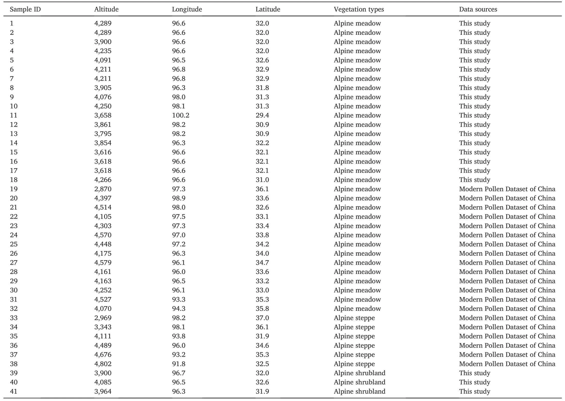
Table 1Location of sampling sites and regional vegetation types on the eastern Tibetan Plateau.
2.Materials and methods
2.1.Study area and sample collection
The study area is located on the eastern part of the Tibetan Plateau(29°02′N–37°50′N,91°49′E–100°09′E)at an altitude of 2,748–4,802 m.It is influenced by the East Asian monsoon;there are strong temperature and precipitation gradients between high summer temperatures (up to 19°C) and precipitation (>700 mm) on the southeastern part of the plateau, and low summer temperatures (–6°C) and precipitation(<100 mm) on the northeastern part of the plateau.The distribution of vegetation on the Tibetan Plateau is largely controlled by precipitation brought by the southeast and southwest monsoons, and land-cover type changes (from south to north) from tropical alpine forest to alpine meadow shrubland,to alpine steppe,to alpine desert.The surface samples studied here were collected from the eastern part of the plateau(Fig.1),from forest,meadow,shrubland,and desert areas.

Fig.1.Study area overview and sampling points.(a) Distribution of sample points; figure cropped from the Chinese digital elevation model (DEM) map.(b) Landcover types in the study area;source of the base map is the 1:1 million vegetation map of China.In(a),the red circles represent the surface pollen samples collected herein from the eastern Tibetan Plateau, and the blue circles represent selected points from the Pollen Dataset of China (Chen et al., 2021).
Sub-alpine coniferous forest on the southeastern part of the Tibetan Plateau consists of evergreen broad-leaved forests in the south and montane coniferous forests in the north.The common coniferous forests are dominated by Abies, Picea (shady slopes), and Juniperus (sunny slopes), usually located between 3,000 and 4,000 m above sea level(a.s.l.).With increasing elevation, the coniferous forest transitions to Ericaceae and Rosaceae shrublands and alpine meadows comprising Caragana and Rosaceae shrublands(Tibetan Investigation Group,1988).
Alpine shrubland and steppe/meadow mainly occur on the relatively open and flat terrain of the eastern part of the plateau.The shrubland consists of Kobresia and Polygonaceae.The alpine steppe is located within the vast area of the plateau hinterland at 4,400–5,400 m a.s.l.,dominated by Poaceae, Cyperaceae, and Artemisia, with commonly associated Astragalus.Alpine meadows are dominated by Cyperaceae,but also commonly contain Persicaria, Thalictrum, Artemisia, Poaceae, Asteraceae,and Caryophyllaceae(Tibetan Investigation Group,1988).
Arid desert occurs mainly in the Qaidam Basin and is often dominated by Chenopodiaceae,including Krascheninikovi,Kali,Haloxylon,Kalidium,and Kalidium cuspidatum, although other arid plants can also dominate(e.g., Ephedra przewalskii, Sarcozygium, Nitraria, Ajania tibetica, and Artemisia desertorum).Some Poaceae(e.g.,Stipa purpurea and Stipa caucasica)and Cyperaceae plants can also form desert-steppe vegetation alongside the more typical desert plants noted above (Zhang,2007).
In November 2019, we sampled along a route through Nangqian,Jiangda,Gongjue,Leiwuqi,Mangkang,and Daocheng counties,collecting 36 surface samples using the conventional plume-point method.Samples were taken from areas of natural vegetation,or areas with little disturbance from human activities, and GPS was used to establish the latitude, longitude,and altitude of each sampling location.Simultaneously,a vegetation survey was conducted to record the main vegetation types at each sampling point.The 36 collected samples were from sub-alpine coniferous forest areas.An additional 39 surface samples were selected from the Chinese Surface Pollen Database (Chen et al., 2021), corresponding to alpine meadow,shrubland-alpine,meadow-alpine,and steppe-arid desert on the eastern Tibetan Plateau.Slide preservation,all pollen extraction laboratory experiments, and statistical analysis for indoor identification were conducted at the Key Laboratory of Ecological Security and Sustainable Development in Arid Regions,Northwest Institute of Ecological and Environmental Resources,Chinese Academy of Sciences.
2.2.Pollen analysis
Pollen was extracted from the samples using conventional acid-base treatment (Miao et al., 2013, 2014).Sample weights ranged from 5 to 20 g,depending on the sample type(5 g for moss and 20 g for soil).Pollen concentrations were calculated by adding stone pine spores(27,637 spores per tablet)to the samples.The samples were chemically treated with 10%hydrochloric acid, 10%sodium hydroxide,and 40% hydrofluoric acid to remove carbonates and some unwanted types of organic matter.Impurities were removed through a 7 mm nylon mesh sieve,centrifuged,and added to glycerol for preservation.Pollen grains were identified and counted using an Olympus light microscope at× 400 magnification.At least 300 terrestrial pollen grains were counted per sample.Pollen identification was based on the pollen and pollen mapping of common plants on the eastern Tibetan Plateau (Cao et al., 2020), and common pollen books of China(Wang, 1995; Tang, 2016).Pollen percentages were calculated based on the total sum of terrestrial pollen grains.Pollen mapping was carried out using Tilia software(Grimm,2011),and pollen mapping was matched to the vegetation for the different land-cover types.
2.3.Modern climate data
The Chinese Meteorological Forcing Dataset (CMFD; gridded nearsurface meteorological dataset at 0.1°spatial resolution) was used to retrieve climate data for the sampling locations for the period 1979–2018(He et al., 2020).The distances between neighboring CMFD grid points were calculated based on their latitude and longitude using the rdist.earth function from package 9.6.1 of R version 3.6.0 (Nychka et al.,2019).Data obtained from the CMFD grid point nearest to each sample location were assigned to that sample.Four climate variables were extracted for each sample point:mean annual precipitation(MAP),mean annual temperature (MAT), mean temperature of the coldest month(Mtco),and mean temperature of the warmest month(Mtwa).
2.4.Numerical analyses
To assess the relationships between modern pollen assemblages and climate, we implemented a log-transformed ordination analysis on the pollen data to stabilize the variance and optimize the signal-to-noise ratio (Prentice, 1980).First, 15 pollen taxa (pollen percentage >3%and occurring in at least three samples) were selected for trend correspondence analysis(DCA;Hill et al.,1980);this showed that the length of the first axis for the pollen data was 1.1 standard deviation (SD)units.This makes it appropriate to use a linear response model (linear gradient <3, and a single peak with amplitude >4) to represent our pollen dataset.We then performed an RDA.Covariance between climatic variables was tested by evaluating the variance inflation factor(VIF), and any variable with high covariance (VIF >20) was excluded until all VIF values were <20.
3.Results
3.1.Pollen assemblages on the eastern Tibetan Plateau
A total of 56 family sporophyte types were identified in the 36 surface samples,mainly herbaceous and low shrubland types,with less common woody types (Fig.2).Herbaceous types included Cyperaceae (0.6%–89.5%), Poaceae (0.3%–58.1%), Artemisia (0.3%–39.0%), Asteraceae(0.3%–12.0%), Rosaceae (0.3%–7.5%), Polygonaceae (0.3%–13.1%),and Ranunculaceae (0.2%–11.4%).Shrubland types included Caragana(0.3%–4.2%), Dasiphora (0.3%–3.0%), Ericaceae (0.3%–2.0%), Quercus(Q.spinosa) (0.3%–30.2%), and Cupressaceae (0.3%–14.8%).Woody types included Abies (0.3%–77.1%), Picea (0.3%–17.8%), Pinus (0.6%–61.2%), Cupressaceae (0.3%–33.4%), Fagaceae (0.3%–30.2%), and Betulaceae (0.2%–6.1%).The 36 surface samples could be divided into alpine meadow,alpine shrubland,and sub-alpine coniferous forest landcover types.The paragraphs below describe how the combinations of pollen in samples from each land-cover type are characterized.

Fig.2.Pollen percentages for samples from the eastern Tibetan Plateau.Pollen types were selected as > 3%, and pollen from different vegetation types is shown divided by dashed lines.
Alpine coniferous forest: samples were collected from 3,221 to 4,505 m altitude, and their pollen content was characterized by a high woody content (42.1%–54.5%, mean 54.1%).The arboreal pollen content decreased with increasing altitude, and included Pinus (32.1%–61.2%, mean 43.1%), Picea (0.9%–2.5%, mean 0.7%), Abies (only 14.5%),Cupressaceae(2.1%–3.3%,mean 2.2%),Fagaceae(0.8%–5.6%,mean 3.8%), and Betulaceae (0.3%–4.1%, mean 1.5%).The average spore powder concentration was 28.7 ×10³grains/g.
Alpine meadow: samples were collected from 3,616 to 4,289 m altitude.The pollen was characterized by a high proportion of Cyperaceae(9.6%–89.5%, mean 52.2%), accompanied by Poaceae (0.3%–28.8%,mean 7.1%), Asteraceae (0.3%–12.0%, mean 3.7%), Artemisia (0.3%–21.0%, mean 4.9%), Rosaceae (0.3%–7.5%, mean 1.5%), Polygonaceae(0.3%–6.0%,mean 1.2%),and Ranunculaceae(0.2%–6.5%,mean 1.9%),and samples had a higher herbaceous content than did woody content.The average pollen concentration was 41.3×10³grains/g.
Alpine shrubland: samples were collected from 3,689 to 4,109 m altitude.There was a decrease in Cyperaceae pollen content (0.6%–61.3%, mean 28.7%), relative to other alpine vegetation types, and increases, relative to other vegetation types, in Poaceae (0.6%–58.1%,mean 12.6%),Artemisia(0.3%–39.0%,mean 11.3%),Asteraceae(0.5%–7.1%, mean 3.3%), and Elaeagnaceae (0.3%–1.4%, mean 0.5%).The alpine shrubland pollen types also included Caragana(0.3%–4.2%,mean 1.1%), Dasiphora (0.3%–3.0%, mean 0.8%), Ericaceae (0.3%–2.0%,mean 0.1%), Cupressaceae (0.3%–14.8%, mean 4.1%), and Quercus(Q.spinosa) (0.3%–30.2%, mean 3.8%).The average pollen concentration was 12.9×10³grains/g.
3.2.Comparing the study area with the eastern Tibetan Plateau vegetation belt at a large spatial scale
To provide a more general comparison and to explore the differences between pollen results for typical land cover types and climatic factors affecting the spatial distribution of pollen,we compared surface data for typical land cover types (data from the China Surface Pollen Database;Fig.3).The detailed pollen percentage profiles are provided in Appendix 1, and the samples were mean-processed to highlight differences between different vegetation types.The results show that different landcover types are associated with different pollen assemblages in the selected samples,and the pollen profiles provide a good representation of the vegetation structure of each land-cover type(Fig.3).

Fig.3.Percentages of major pollen types in surface samples from the eastern Tibetan Plateau.Con: Picea + Abies + Pinus + Cupressaceae; Arboreal: Coniferous forests + Betulaceae + Fagaceae; Art: Artemisia; Ast: Asteraceae; Cyp: Cyperaceae; Poa: Poaceae; O.H: Rosaceae + Polygonaceae + Ranunculaceae +Thalictrum + Umbelliferae + Brassicaceae + Fabaceae + Caryophyllaceae + Gentianaceae; Che: Chenopodiaceae; D.S: Ephedraceae + Tamaricaceae+Nitraria+Calligonum.The pollen data represent a combination of pollen percentage data from samples collected herein from the eastern Tibetan Plateau and samples from the Chinese Surface Pollen Database.
Alpine coniferous forest: five samples were taken from altitudes of 3,221–4,505 m.The main pollen type was that of coniferous forest taxa(46.7%).In these alpine coniferous forest surface samples, the highest percentage of pollen was from arboreal species(54.1%),accompanied by lower percentages from Cyperaceae(9.6%),Poaceae(6.8%),Asteraceae(3.2%),Artemisia(7.9%),Chenopodiaceae(0.3%),and desert shrubland(0.0).Arboreal species (e.g., Picea, Abies, and Betulaceae) contributed 54.1% of the pollen in the alpine coniferous forest land-cover type,compared with 46.7%in other coniferous forests.
Alpine meadow: thirty-two samples were collected from altitudes of 2,869–4,579 m.Cyperaceae was the dominant pollen type (53.9% on average).The highest herbaceous percentage content for these samples was 81.1%, dominated by Poaceae (5.3%), Asteraceae (5.3%), and Artemisia (4.3%).The low arboreal content of the samples (11.0%) was dominated by coniferous forests taxa (7.3%), and low percentages were found for Chenopodiaceae (2.6%) and desert shrubland taxa (0.2%).Eighteen of the 32 samples were collected from above the forest line,so it is plausible that some alpine meadow samples include arboreal pollen.In the alpine meadow, the herbs adapted (e.g., Cyperaceae, Poaceae, Asteraceae)species of 81.1%,Cyperaceae of 53.9%,and Poaceae of 5.3%.
Alpine shrubland: eighteen samples were collected from altitudes of 3,689–4,518 m.With increasing altitude, these samples contained a decreasing percentage of Cyperaceae (29.6%) and an increasing percentage of other shrubland pollens, such as Poaceae (12.7%), Artemisia(12.1%), and Asteraceae (3.9%).The herb percentage content of the samples was highest (45.2%), and the arboreal percentage content increasing percentage(23.6%),mainly in samples taken from coniferous forests (17.2%), Cupressaceae (3%) and Quercus (Q.spinosa) shrubland(2.8%),with lower percentage contents in samples from Chenopodiaceae(0.8%)and desert shrubland(0.5%).The pollen assemblages varied little between samples; fluctuations were <30%.All samples were consistent with the alpine meadow and were collected from above the forest line,so the percentage of arboreal was higher in the alpine shrubland samples than in the samples from other vegetation types.In alpine shrubland,the herbs adapted(e.g., Cyperaceae, Poaceae, Asteraceae) species of 45.2%,Cyperaceae of 29.6%,and Poaceae of 12.7%.
Alpine steppe: six samples were collected from altitudes of 2,969–4,802 m.Relative to the other land-cover types, the percentage content of Cyperaceae decreased (to 27.7%), while those of Chenopodiaceae and Artemisia increased(to 17.6%and 17.9%,respectively).The percentage contents of the latter two pollens did not differ much in general, but the percentage content of Artemisia was always slightly higher than that of Chenopodiaceae.There was little variation between pollen assemblages, with small fluctuations (<30%), and no coniferous or arboreal pollen was present.The species of herbaceous taxa in the alpine steppe comprised 58.5% Cyperaceae and 22.8% Artemisia.
Arid desert: fourteen samples were collected from altitudes of 2,748–3,662 m.The main pollen type was Chenopodiaceae (58.5%);relative to the other land-cover types,there was a sharp decrease in the herbaceous percentage content (4.8%), and this was dominated by Artemisia(6.6%).No coniferous or arboreal pollen was present.The aridadapted taxa (e.g., Chenopodiaceae, Ephedraceae, and Nitraria)comprised 58.5% Chenopodiaceae and 22.8% other arid-adapted shrubland taxa.
3.3.Interpolation of climatic factors
The Chinese Meteorological Forcing Dataset(CMFD)is a widely used climate dataset, particularly in the Tibetan Plateau region where meteorological stations are scarce (Ma et al., 2017; Cao et al., 2021; Wang et al.,2022).For our study,we selected relevant climatic factors from the CMFD and used ArcGIS software(v.10.8)to implement ordinary kriging interpolation and derive meteorological maps for our study area(Fig.4).The modern spore powder samples cover the ranges for MAP(49–732 mm), MAT(-6.6 to 6.2°C),and Mtco(-18.9 to-4.2°C).

Fig.4.Multi-year climate interpolation results for the eastern–northeastern Tibetan Plateau.(a) MAP.(b) MAT.(c) Mtco.(d) Mtwa.Red boxes show the area from which surface spore powder samples were collected herein from the eastern Tibetan Plateau.
3.4.Numerical analysis
To understand the relationships between pollen assemblages and climate on the eastern-northeastern Tibetan Plateau, we used an RDA linear model with MAP, MAT, Mtco, and Mtwa as the main environmental variables, together with 15 modern pollen genera, and four climatic variables.The correlation ranking test was statistically significant for the selected variables,with P=0.002.Meta-linear regression resulted in VIFs >20 for MAT, Mtco, and Mtwa, indicating strong correlations between them.We removed MAT because it is an annual average and ignores seasonal variations.This resulted in all other VIF values reducing to <20, indicating low covariance between MAP, Mtco, and Mtwa.The MAP captured the maximum variance of the dataset,indicating that MAP has the greatest influence on the composition and distribution of pollen assemblages in the dataset.The MAP positively correlated with Cyperaceae, Poaceae, Rosaceae, and Asteraceae, and negatively correlated with Chenopodiaceae, Ephedraceae, Nitraria, Calligonum, and Tamaricaceae.Our RDA analysis divided the pollen taxa into three groups(Fig.5).Pinus, Picea, Abies, Cupressaceae, Fagaceae, and Betulaceae positively correlated with Mtco,as can be seen by the presence of these cold-climate pollen taxa, which have a higher abundance in alpine coniferous forests, in the lower left quadrant of Fig.5.The Mtco in the preceding year had some influence on plant growth and rejuvenation each year, and plant rejuvenation increased with higher temperatures and precipitation in winter and spring.The temperature of the coldest month had a greater effect on plant regrowth than did the spring temperature(Ding et al.,2011).Cyperaceae,Poaceae,Artemisia,Asteraceae,Caryophyllaceae, Rosaceae, Polygonaceae, and Brassicaceae positively correlated with MAP,as shown in the upper left quadrant of Fig.5;this indicates that wet climatic conditions are important to alpine meadow shrubland and alpine steppe, where an increase in MAP results in an increase in plant-available water and thus promotes plant growth.Chenopodiaceae, Ephedraceae, Tamaricaceae, and Calligonum positively correlated with Mtwa and negatively correlated with MAP.These appear in the lower right quadrant of Fig.5, reflecting a warm and dry pollen assemblage accompanied by scarce precipitation and warm temperature,suitable for the growth of drought-tolerant plants.

Fig.5.Redundancy analysis of major pollen taxa in samples from the eastern–northeastern Tibetan Plateau.
4.Discussions
4.1.Pollen assemblages of typical land-cover types
The pollen assemblages of the eastern-northeastern Tibetan Plateau were dominated by shrubland and herbaceous varieties, while the amount of arboreal pollen was low everywhere except for in the alpine coniferous forest zone (Annex 1 for detailed pollen mapping).Overall,the percentage content of different vegetation types in the pollen assemblages and their spatial distributions reflected the vegetation occurring within the different land-cover types.
Alpine coniferous forests mainly occur in the eastern part of the Tibetan Plateau, where MAT and MAP are relatively high (1.4°C and 669.70 mm,respectively).The pollen assemblage in this area has a high arboreal content, dominated by the arboreal taxa Picea (0.7%), Abies(2.9%), Pinus (43.1%), Cupressaceae (2.2%), Betulaceae (1.5%), and Fagaceae (3.8%) (Fig.6).Previous studies of modern pollen on the southeastern and southwestern Tibetan Plateau have also shown arboreal taxa (Pinus, Picea, and Betulaceae) to be a major component of spore pollen assemblages(Shen et al., 2006; Ma et al., 2017), which is consistent with our results.
Alpine meadows mainly occur on the eastern–northeastern Tibetan Plateau,where MAT(-1.17°C)and MAP(495.4 mm)are lower than in alpine coniferous forests.Alpine meadows had a high herbaceous content,with Cyperaceae(53.9%),Poaceae(5.3%),Asteraceae(5.2%),and Artemisia(4.3%)forming the dominant species(Fig.6).Previous studies of the alpine meadow zone of the eastern-northeastern Tibetan Plateau have found Cyperaceae to be the dominant species and main pollen type in the pollen assemblage,consistent with our results(Sun et al.,2017;Li,2020;Shen,2021;Wang et al.,2022).
Arid desert mainly occurs in the Qaidam Basin on the northeastern Tibetan Plateau,with low MAT(-1.7°C)and low MAP(130.8 mm).The pollen assemblage from our arid desert samples was dominated by Chenopodiaceae (58.5%), Ephedraceae (8.1%), Nitraria (5.3%), and Tamaricaceae (2.5%) (Fig.6).Qin (2021) collected 34 lake surface sediment samples from steppe and desert regions of the Tibetan Plateau and found that modern pollen assemblages from the plateau desert contained high levels of Chenopodiaceae and Artemisia.Our results are consistent with this and other previous studies (e.g., Herzschuh, 2007).The modern pollen assemblages in surface sediments from arid desert regions of the Tibetan Plateau are similar to those found in warm and arid desert regions of northwest China,which are dominated by pollen from Chenopodiaceae and Artemisia, while pollen from drought-loving plants such as Ephedra and Nitraria is also common (Zhao et al., 2009b, 2012;2021b).Although there is geographical separation between the desert regions in China, there is a high degree of consistency in the dominant and characteristic taxa of the modern pollen assemblages in their surface sediments.
4.2.Representation of major pollen types
There are inevitably some differences between pollen assemblages in samples and the actual vegetation within each land-cover type owing to differences in pollen production,dispersal,and preservation.Therefore,errors will arise when pollen combinations are used to reconstruct vegetation characteristics, especially when reconstructing paleovegetation;however,such errors can be at least partially addressed using pollen representation.Pollen in the eastern Tibetan Plateau region consists mainly of arboreal Cyperaceae, Poaceae, Artemisia, and Chenopodiaceae pollen, which is consistent with earlier findings from Tibetan Plateau surface sediment samples (Yu et al., 2001; Shen et al., 2006;Herzschuh, 2007; Zhao and Herzschuh, 2009a; Wang et al., 2022).The topography, precipitation conditions, and distribution of vegetation types are complex on the Tibetan Plateau; hence, we studied typical pollen types to gain a more refined understanding.These pollen types included arboreal Cyperaceae,Poaceae,Artemisia,Chenopodiaceae,and Ephedraceae taxa,which account for 74.5%of the pollen in our samples from the Tibetan Plateau.
Ephedraceae pollen mostly occurred in our temperate desert samples(Fig.6a),with percentages ranging from 0.2%to 35.6%.The abundance of Ephedraceae pollen was relatively high in areas where Ephedraceae taxa were present in the modern plant assemblage,while in areas where Ephedraceae were absent, the abundance of Ephedraceae pollen in our samples was low or zero.Our results are consistent with those of other studies from the Qaidam Basin on the northeastern Tibetan Plateau(Zhao and Herzschuh,2009a;Zhang et al.,2012).
Chenopodiaceae pollen mainly occurred in our temperate desert samples(Fig.6b)and,in places,comprised a very high percentage of the surface samples (0.2%–96.3%).It was mainly distributed along the northeastern Qaidam Basin margin and gradually increased from south to north;more than 40%of the Chenopodiaceae in the study area was found on the northeastern Tibetan Plateau.The proportion of Chenopodiaceae in the surface samples was hyper-representative of the aridity of the study area; samples from arid desert regions of the northern Tibetan Plateau were characterized by a high average proportion of Chenopodiaceae (2.4%–96.3%, mean 61.0%), while samples from steppe vegetation on the northern Tibetan Plateau were characterized by a reduced average proportion of Chenopodiaceae (1.1%–4.3%, mean 2.1%).Our findings are consistent with those of other studies from the Qaidam Basin on the northeastern Tibetan Plateau(Zhao and Herzschuh,2009a;Zhang et al.,2012)and Xinjiang(Luo et al.,2006;Zhao et al.,2015,2012).
Currently, Artemisia is widely distributed in steppe, desert steppe,steppe forest,Gobi,and alpine and sub-alpine steppe regions,growing in meadows and on gravelly slopes, and a few species also grow on the edges of montane forests or in shrubland.We found a relatively high abundance of Artemisia pollen in our surface samples (0.2%–79.2%;Fig.6c).In our study area,Artemisia pollen was mainly distributed in the alpine steppe zone(17.9%)and arid deserts(6.6%)on the northeastern part of the Tibetan Plateau, while it also occurred in alpine shrubland meadows(4.3%)and alpine coniferous forest(7.9%;Fig.6c).Artemisia is over-represented in our samples because of the high rate of Artemisia pollen production and the ease with which it is dispersed.Fine Artemisia pollen is easily picked up by the wind and transported long distances,resulting in an over-representation of Artemisia pollen in most samples,relative to the actual cover of Artemisia (Xu, 1996; Herzschuh et al.,2003).
Poaceae are the building plants for meadow and steppe habitats and grow over a wide range of conditions, from tropical to frigid temperatures,acidic to saline soils,mountains to plains,and deserts to forests.In our study area,Poaceae(Fig.6d)accounted for the highest proportion of the total pollen content of the samples (58.01%).The average Poaceae pollen contents of samples from steppe communities and meadow areas were 2.2%and 5.3%,respectively,which is low when compared with the actual cover of Poaceae.This means that the vegetation composition cannot be accurately reconstructed from the Poaceae content of the pollen assemblage, and it is necessary to derive the R-value for these areas.It is generally accepted that Poaceae is under-represented in pollen assemblages, possibly owing to the low production rate and thin outer wall of Poaceae pollen(Cushing,1967).Previous studies have found an average of 3%–6% Poaceae in pollen assemblages for areas where it exists as a dominant and established species in the modern vegetation cover(Wang et al.,1996;Xu, 1996;Liu et al.,1999).
Pinus was mostly present at high levels(0.5%–61.2%,mean 14.1%)in alpine coniferous forests (Fig.6e), while samples from alpine meadows and shrubland contained low percentages of Pinus (<5%).The higher pollen content of Pinus compared with other genera indicates that it is super-representative;this is related to the high production rate and two well-developed air sacs of Pinus pollen, meaning that it can be transported over longer distances via air currents (Wang et al., 1983).It has been suggested that when the pollen content of Pinus is<30%,it can be concluded that no local Pinus stands are growing, and pollen has been transported from outside the region (Li et al., 1990;Li, 1991a; Xu et al.,2007).
Most Picea occur in alpine coniferous forests.We found that the content of arboreal pollen(Fig.6f)was high(0.3%–77.1%,mean 8.9%)in alpine coniferous forests,while in alpine shrubland and meadows close to coniferous forests it was<20%.The pollen production rate of Picea is particularly high,much higher than that of other seed plants,and higher than that of Pinus and Betula.The settling speed of Picea pollen is also relatively fast compared with other pollen types.Its air sacs are relatively small, so less likely to be carried long distances; hence, Picea pollen mostly lands around the mother arboreal plant(Liu et al.,1999;Minckley and Whitlock,2000).Previous results have shown that within and at the margins of Picea forests, Picea pollen content is above 20%–80%; at the boundary of Picea forests,it accounts for approximately 10%;and when the Picea content is below 5%,this may indicate that no local or nearby spruce forests are present, and this pollen comes from long-distance dispersal(Wang et al.,1983;Li et al.,1990;Li, 1991b).
Cyperaceae are mainly distributed in alpine meadows and alpine shrubland.Cyperaceae pollen was present in most of the surface samples from our study area(Fig.6g).The average Cyperaceae content of samples from the alpine meadow region was 53.9%, and the highest content in these samples was 94.9%.The Cyperaceae content of samples from steppe areas was <20%, and that in samples from shrubland areas was generally <30%, owing to the proximity of meadow environments.Samples from other sample sites generally contained<10%Cyperaceae,which indicates that Cyperaceae may have low representativeness,but is nonetheless a good vegetation indicator.These results are consistent with the fact that the Cyperaceae content of our samples generally correlates positively with local precipitation and negatively with temperature(Shen et al.,2006;Luo et al.,2010).
The arboreal pollen content was high for samples from alpine coniferous forests (42.1%–76.3%, mean 57.8%), and low for samples from other vegetation types(<5%),except for alpine shrubland and meadow areas adjacent to alpine coniferous forests, where the arboreal content was <10% (Fig.6h).The relatively low arboreal pollen content of samples from outside the forest area indicates low transport efficiency,with most arboreal pollen deposited near its source(Fig.6h).
4.3.Pollen assemblages and climate
Different land-cover types form under different climatic conditions on the Tibetan Plateau;we conducted an RDA to discover the relationships between pollen assemblages and climate for vegetation comprising the different land-cover types on the eastern-northeastern Tibetan Plateau.Our modern pollen assemblages in surface samples from the eastern Tibetan Plateau were strongly correlated with climatic variables MAP,Mtco, and Mtwa.Among these, MAP was the most important climatic factor affecting the distribution of modern pollen in our study area(Fig.5).In arid and semi-arid regions of the Tibetan Plateau and northwestern China, precipitation drives vegetation cover and composition,and is the most important climatic influence on pollen assemblages(Herzschuh et al., 2010; Zhang et al., 2012; Wei et al., 2016; Cao et al.,2021).Thus, the modern pollen data from our eastern Tibetan Plateau samples reflect an arid signal, in agreement with previous studies(Herzschuh et al.,2010;Cao et al.,2021).
Samples from alpine meadow and alpine coniferous forest regions were associated with relatively high MAP (>400 mm) and the pollen assemblages were dominated by Cyperaceae and arboreal taxa.In contrast, samples from temperate deserts, dominated by Chenopodiaceae and Ephedraceae pollen,were associated with relatively low MAP(<75 mm).Artemisia and Poaceae were more widely distributed than these latter taxa and occurred over relatively large precipitation gradients (49.6–723.6 mm; Fig.7).The five vegetation types in our study area-alpine coniferous forest,alpine shrubland,alpine meadow,alpine steppe, and arid desert-have different climatic distributions (Fig.6).Alpine coniferous forests occur in relatively warm and humid climates(1.4°C, 669.8 mm), while arid deserts require warmer (2.3°C) and drier (122.5 mm) climates.Differences in temperature and precipitation between alpine meadow, alpine shrubland, and alpine steppe regions are small, but alpine shrubland has a somewhat wider temperature range and somewhat narrower annual precipitation range(Table 2).

Fig.7.Relationship between major pollen types and MAP on the eastern Tibetan Plateau.
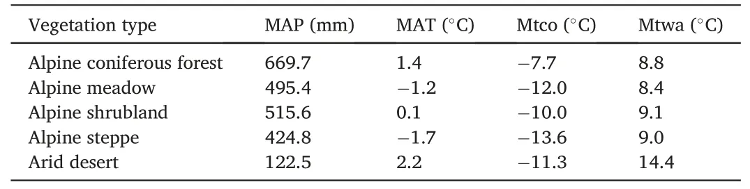
Table 2Average values of climatic factors for different vegetati on types.
In summary,our RDA results and the climatic distribution of different land-cover types show that pollen assemblages may reflect the distribution of land-cover types, and thus may also reflect climatic conditions.The spatial pattern of surface pollen assemblages varies with climate,and so provides a reference for the reconstruction of paleoclimate on the eastern Tibetan Plateau.
4.4.Climatic significance of the pollen ratio
Different pollen ratios can be used to indicate the condition of the surrounding vegetation,and thus the corresponding climate.A common example is the Artemisia to Chenopodiaceae (A/C) ratio (Weng et al.,1993; Zheng et al., 2008; Zhao et al., 2009b, 2021b).To better understand the climatic relationships between different land-cover types and pollen, and explore meaningful indicators, we conducted pollen ratio analyses for the eastern–northeastern Tibetan Plateau;we looked at the A/C ratio and the ratio of the sum of Cyperaceae and Asteraceae(Cy + As) to the sum of Artemisia and Chenopodiaceae (A + C),[(Cy+As)/(A+C)].
The A/C values increased from a mean of 3.6 in alpine meadows to 5.1 and 10.2 in alpine steppe and alpine shrubland regions,respectively;they were highest in alpine coniferous forests (11.1) and lowest in arid deserts(0.3).Statistical analysis revealed that arid deserts had A/C<1,while A/C was>1 for the other four land-cover types.This shows that A/C can be used to distinguish between desert and non-desert zones of the eastern Tibetan Plateau.The correlation factors between A/C and MAP,Mtco,Mtwa,MAT,and altitude were 0.34,0.26,-0.07,0.10,and-0.08,respectively(i.e.,there was a positive correlation between A/C and MAP and Mtco, and no significant correlation between A/C and Mtwa, MAT,or altitude;Table 3).Cour et al.(1999)found that A/C values for saline desert, montane desert, and alpine steppe regions on the northwestern Tibetan Plateau were <1, 1–2, and >2, respectively.Ma et al.(2017)conducted a logistic regression analysis of A/C for 42 lake surface sediment samples from the central and western Tibetan Plateau and concluded that an A/C of 1.2 could be used as a threshold to distinguish between steppe and desert land-cover types.Our results are consistent with these studies.

Table 3Correlation analysis between different pollen ratios and climatic factorson the eastern Tibetan Plateau.
In our study, (Cy + As)/(A + C) decreased from 40.17 in alpine meadows to 8.79 in alpine grasslands and 6.01 in alpine shrublands,while this ratio was 4.39 and 0.35 in coniferous forests and arid deserts,respectively.Statistical analysis showed that(Cy+As)/(A+C)was<1 for arid deserts and >1 for the other four land-cover types.This shows that (Cy + As)/(A + C) can be used to distinguish between desert and non-desert land cover in our study area.The coefficients for correlations between (Cy + As)/(A + C) and MAP, Mtco, Mtwa, MAT, and altitude were 0.16,-0.04,-0.15,-0.11,and 0.29,respectively(i.e.,there was a positive correlation between (Cy + As)/(A + C) and MAP, MAT, and altitude, and no significant correlation between (Cy + As)/(A + C) and Mtco or Mtwa;Table 3).The(Cy+As)/(A+C)values tended to increase with increasing altitude(Fig.8);hence,they may also be an indicator of altitude.

Fig.8.Relationships between pollen ratios and climate.The black curves show fits calculated using locally weighted regression (LOESS).
5.Conclusions
Modern pollen assemblages and pollen ratios reflect vegetation distribution on the eastern Tibetan Plateau, but their significance varies between different land-cover types and is influenced by precipitation and temperature.Understanding modern pollen assemblages and their relationships with vegetation and climate is important for reconstructing paleovegetation and paleoclimate.Our study shows that modern pollen assemblages in surface sediments are closely related to vegetation and climate.Our main conclusions are summarized below.
We combined a field vegetation survey with characteristics of surface pollen assemblages for three land-cover types,comprising different types of vegetation,on the eastern Tibetan Plateau:alpine coniferous forest,alpine meadow,andalpineshrubland.Thepollenassemblagesinsurfacesediments correlated well with the regional vegetation distribution on the eastern Tibetan Plateau,indicating that pollen in sediments within this region reflects the vegetation(and any changes to it)and that surface pollen assemblages generally reflect overall characteristics of the modern vegetation.
We examined data from the Chinese Surface Pollen Database and found that both temperature and precipitation determine the variability of pollen assemblages in the study area.The five land-cover types in the study areaalpine coniferous forest,alpine meadow,alpine shrubland,alpine steppe,and arid desert-have different climatic distributions.The alpine coniferous forest pollen assemblage corresponds to a cold and wet environment,and the arid desert pollen assemblage corresponds to a warm and dry climate.Pollen assemblages for the alpine steppe, alpine meadow, and alpine shrubland land-cover types correspond to climatic conditions somewhere in between those of the alpine coniferous forest and arid desert assemblages.The results of our RDA show that multiple climatic factors jointly influence the distribution of surface pollen in the study area; MAP is the most important climatic factor controlling the pollen assemblage.
In our study area, A/C acts as an effective indicator to distinguish temperate desert from other vegetation types;(Cy+As)/(A+C)can also be used as an effective indicator to distinguish between temperate desert and other vegetation types, and may be a useful altitude index for the eastern Tibetan Plateau.
Acknowledgments
This project was supported by the NSFC (42161144012, 42030505,42271176, and 41972020), the Western Light Project of CAS (xbzgzdsys-202204) and Youth Innovation Promotion Association of CAS(2022439).We thank the members of Prof.Miao's group and the anonymous reviewers for their discussions and constructive suggestions.We thank the team of Prof.Song C at Lanzhou University and the team of Prof.Wang Y at the Northwest Institute of Eco-Environment and Resources,CAS,for their help with sample collection.
Appendix
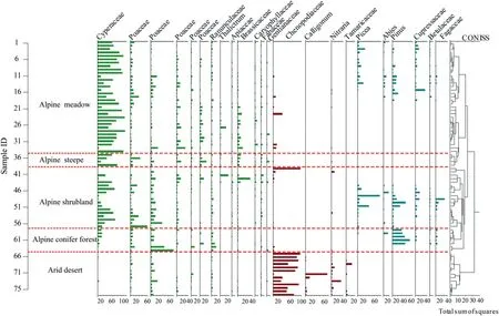
Chart of pollen percentages on the eastern Tibetan Plateau.Pollen types were selected as>3%,and pollen from different vegetation types is shown divided by dashed lines (The data consisted of samples collected by This study and samples from the Modern Pollen Dataset of China, details of which are shown in Table 1).
 Sciences in Cold and Arid Regions2023年2期
- Sciences in Cold and Arid Regions的其它文章
- Long-term feeding of sand rice (Agriophyllum squarrosum seed) can improve the antioxidant capacity of mice
- Ecosystem changes revealed by land cover in the three-river headwaters region of Qinghai, China (1990–2015)
- Parameter sensitivity analysis for a biochemically-based photosynthesis model
- Temporal and spatial variation of cloud cover in arid regions of Central Asia in the last 40 years
- Editor-in-Chief Yuanming Lai
- Experimental study on mechanical and frost heave behaviors of silty clay improved by polyvinyl alcohol and polypropylene fiber