
Ecosystem changes revealed by land cover in the three-river headwaters region of Qinghai, China (1990–2015)
2023-08-29 03:38:40XuWeiSunSenLiXioHuiZhiXioXuWeiChngZhenYn
XuWei Sun, Sen Li, XioHui Zhi, XioXu Wei, ChngZhen Yn
a Gansu AcademyofEco-environmentalSciences, Lanzhou,Gansu 730020, China
b Key LaboratoryofEcologicalSafety andSustainableDevelopmentinArid Lands, Northwest Institute of Eco-Environment and Resources, Chinese Academy of Sciences,Lanzhou, Gansu 730000,China
c College ofSocialDevelopmentand Public Administration, Northwest Normal University, Lanzhou, Gansu 730070, China
Keywords: Three-river headwaters region Ecosystem change Land cover Affecting factor
ABSTRACT The Three-River Headwaters Region (TRHR) of Qinghai Province, in the Tibetan Plateau of China, is the main source of the Yangtze, Yellow, and Lancang rivers, and is very significant to the security of freshwater resources for China and southeastern Asia.It is a critical ecological region of China for its ecological functions,and has been changed or even degraded in recent decades owing to climate change and human pressure.To effectively protect and restore the degraded ecosystems,the Chinese government initiated a series of ecological conservation projects in TRHR.It is essential to quantitatively assess ecosystem changes and their relationship to driving factors for indepth understanding of long-term changes of ecosystems and effects of ecological restoration policies and offer practical insights for ecological restoration.Here, land cover data has been interpreted with the series data of Landsat during 1990–2015.The patterns of different ecosystems and their developing process have been derived from land cover change.The results show that ecosystem types in TRHR include forest, grassland, cropland,wetland, artificial surface and barren land, accounting for 4.51%, 70.80%, 0.15%, 9.47%, 0.16% and 14.90%,respectively.Barren land converted to wetland was the significant ecosystem change from 1990 to 2015.Increases in temperature and precipitation and implementation of ecological rehabilitation helped maintain relatively stable ecosystem patterns.It is necessary to continue ecological projects to improve and/or maintain the ecosystems in TRHR because there is still a risk of land degradation under increasing climate change and human activity.
1.Introduction
The Three-River Headwaters Region (TRHR) of Qinghai Province,China, is the source region of the Yangtze (YTR), Yellow (YLR) and Lancang rivers (LCR), located in the Tibetan Plateau's hinterland.This plateau is considered as the world roof and is a significant ecological security zone and strategic resource reserve for China (Zheng and Yao,2004).TRHR,one of the cleanest and unpolluted areas globally,supplies 42.6 billion tons of fresh water every year.The water occupies 2%,38%,and 15% of YTR, YLR and LCR's total water, respectively (Meng et al.,2020).Thus TRHR is termed as the Chinese Water Tower, and it has numerous conservation regulation functions of water resource.The unique location,abundant natural resources and crucial ecological role of TRHR are critical to water conservation and ecological security for China and southeastern Asia(Xu et al.,2017;Shen et al.,2018;Li et al.,2020a,2020b;Mahmood et al.,2020).Because of the high elevation and harsh environment,the ecosystem of TRHR is too fragile to resist distortion and restore (Liu et al., 2017).Once the ecosystem is damaged, it is hard to restore it for an extended period.TRHR has experienced warming change at a rate approximately twice that observed globally(Teng et al.,2018).With the coupled effects of climate change,population growth,livestock overgrazing and rodent damage(Wen et al.,2010;Zhang et al.,2017),the ecosystem of TRHR has changed (Graf, 2013) and suffers from severe ecological degradation,including vegetation degradation,glacier retreat,the rising snow line, soil and water loss, and permafrost degradation(Shen et al., 2018; Mahmood et al., 2020; Sun et al., 2020).The deterioration of the ecological environment will have an irreparable negative impact on the economic and social development of Qinghai Province and even the whole country of China.To some extent, it will affect national rejuvenation and world ecological security(Wei et al.,2020).
On the other hand,ecological conservation also influenced ecosystem change(Graf,2013;Jiang and Zhang,2016).Since 2000,the government of China has implemented a series of eco-environmental protection measures in TRHR.These measures have played an essential role in restoring the ecological environment and slowing land desertification and grassland degradation (Li et al., 2011; Zhang et al., 2014).Alpine has transformed from a net carbon source into a net carbon sink(Xu et al.,2016).
In ecology, ecosystem shifts can abruptly affect hydrology, climatic and terrestrial systems, leading to degraded ecosystems and impoverished societies (Watson et al., 2018; Cooper et al., 2020).It remains unknown whether climate change or ecological conservation leads to substantial changes in the ecosystem of TRHR.Understanding spatial and temporal variations in the ecosystem and its interaction with climate change and anthropogenic activities are essential to ecological monitoring and ecosystem management and greatly enhance environmental management and promote sustainable development.The Plateau has also become a hot spot for global climate change and the corresponding ecosystem feedback (Shen et al., 2015).However, most of these studies were at regional scales, and their time scales were too short for developing a complete understanding of the ecological changes in TRHR(Shen et al.,2015;Xu et al.,2017;Zhang et al., 2019;Li et al.,2020a).
This study aims to provide an objective assessment of ecosystem status and change, including pattern and quality from 1990 to 2015 on comprehensive remote sensing data analysis, explore the underlying factors that drive ecosystems, and demonstrate the trend of ecosystem development.
2.Study area and data processing
2.1.Study area
TRHR has a total area of 28.20 × 10⁴km2, which comprises 147,761 km2of YTR basin,97,455 km2of YLR basin,and 36,766 km2of LCR basin.TRHR has a complex terrain with mountains as the landscape's basic framework (Fig.1).The elevation increases from southeast to northwest, ranging from 1,988 to 6,715 m.The region has a typical mountain plateau climate and is characterized by intense solar radiation,low air temperature and broad diurnal temperature range (Xu et al.,2016; Mahmood et al., 2020; Wang et al., 2020).Because of its average elevation above 4,000 m,the annual average temperature range is-5.6 to 7.8°C.The distribution of the temperature is opposite to altitude,and the temperature shows a gradual decrease from southeast to northwest(Liang et al., 2016; Zhai et al., 2020).Annual precipitation is between 262.2 and 772.8 mm, and the precipitation shows a gradual decrease from southeast to northwest (Shi et al., 2016).The annual potential evapotranspiration ranges from 1,200 to 1,685 mm (Chu et al., 2019).The annual sunshine hour is between 2,300 and 2,900 h,and the spatial difference of sunshine hour is relatively small in TRHR.As China's significant extensive wetland, TRHR has abundant river, lake, mountain snow, and glacier resources and has the world's largest alpine wetland ecosystem.Affected by unique natural features such as landforms and climate, TRHR forms a unique alpine vegetation system (Zheng et al.,2020), including alpine meadow,alpine steppe,and sparse alpine vegetation.However, due to the region's high altitude and harsh natural conditions, its ecosystem is fragile.In recent years, the ecosystem has changed because of climate warming and increasing human activities,and the region's ecosystem is at risk of degradation.Against this background, the state council promulgated and implemented an ecological project entitled Overall Planning of Eco-environment Protection and Construction in TRHR, commonly called the TRHR Project (Jiang and Zhang,2016).

Fig.1.Geographic location of the Three-River Headwaters Region of Qinghai is shown as the shaded region where the topography is higher than 1,800 m.Red dashed contour lines shows the boundaries between counties in Qinghai.
2.2.Data processing
Ecosystem dataset of TRHR was derived from land cover data produced by interpreting Landsat images downloaded from the USGS website (http://glovis.usgs.gov/).Landsat satellites have been collecting multispectral images of the Earth at a 30-m spatial resolution since 1984 with the launch of Landsat 5, forming an accessible global archive courtesy of the Landsat Global Archive Consolidation (LGAC) initiative(Wulder et al., 2016).The acquired times of images used in this study cover years of 1990–2015 and at intervals of five years.The remote sensing data used in 1990,1995,2005 and 2010 are Landsat TM images,data in the year 2000 is Landsat ETM images,and data in 2015 is Landsat OLI images.The spatial resolution of these images is 30 m.It was challenging to acquire cloud-free images of the whole study area within a given year due to the study region's large geographical span.Consequently, some images from previous or subsequent years were used as replacements in a given year.
Land cover data,with 25 types in 2010 was interpreted with Trimble's eCognition Developer software that allows for greater flexibility in parameterization of inputs.The images were segmented into different objects according to differences in object features of spectrum,shape and texture.Classification rule sets,resulting in a decision tree,automatically classify objects into land cover by hierarchical classification.Land cover data in 1990,1995,2000,2005 and 2015 were produced by the spectral vector change detection method(Song and Yan,2014).The classification accuracy for land cover data was assessed through ground surveys,photos, and interviews with local people.The overall accuracy was around 90%(Ouyang et al.,2015).
The 25 types of land cover identified in the study area were categorized into six types of ecosystems, i.e., forest, grassland, cropland,wetland, artificial surface and barren land.In the ecosystem pattern assessment, the area of each ecosystem type and transfer area between different ecosystem types have been calculated by the transfer matrix.The calculation formula is as follows:
where,A is the area;i,j(i,j=1,2,...,n)is the type of ecosystem before and after the transfer; Aijis the area where the ecosystem type changes from type i to j,and n is the number of ecosystem types before and after transfer.
Meteorological data were derived from the China Meteorological Science Data Sharing Service Network (http://cdc.cma.gov.cn/h ome.do).12 weather stations were selected in TRHR, and the temperature and precipitation data were collected from 1990 to 2015 (Fig.1).Among the 12 weather stations,Wudaoliang,Tuotuohe,Qumalai,Yushu and Qingshuihe stations situated in YTR basin; Xinghai, Dari, Maduo,Henan and Jiuzhi stations situated in YLR basin; Nangqian and Zaduo stations situated in LCR basin.Mean temperature and annual precipitation of the 12 weather stations were calculated to analyze its response to the ecosystem.
People and livestock data of 17 counties in TRHR were collected from 1990 to 2015 Qinghai Provincial Statistical Yearbooks.Tanggula Mountain Town data was collected from the Golmud City People's Government Network (http://www.geermu.gov.cn).The data included population number, and the number of large livestock and sheep from 1990 to 2015.Large livestock was calculated as four sheep units.
3.Results and discussions
3.1.Ecosystem status in 2015
TRHR is an important region for global biodiversity conservation and an important barrier for climate stability in East Asia (Wei et al.,2020).The six ecosystem types in the TRHR region include forest,grassland, cropland, wetland, artificial surface and barren land, accounting for 4.51%, 70.80%, 0.15%, 9.47%, 0.16% and 14.90%,respectively (Fig.2).
Forest occupies 12,724.19 km2, most of which is made up of deciduous broadleaf shrubland, accounting for 91.85% of the forest area,while other types of forest include deciduous broadleaf forest,evergreen needle leaf forest, sparse forest and sparse shrubland, accounting for 0.03%, 6.01%, 0.02% and 2.10% of the forest area, respectively.Forest are mainly distributed in the eastern and southern part of TRHR with lower altitude and humid climate.Grassland occupies 199,640.29 km2,and is the dominant type of ecosystems in TRHR and is distributed in almost the whole region.Grassland includes temperate steppe, alpine steppe, temperate meadow, alpine meadow, and sparse grassland, accounting for 22.67%, 17.074%, 2.91%, 32.46% and 24.2% of the grassland area,respectively.Farmland occupies 426.80 km2,mostly dry farmland,and is mainly distributed in the northeast of the YLR.Wetland occupies 26,717.31 km2.Qinghai Province has the largest area of wetland in China,and 90%of the wetlands is located in the TRHR region(Wei et al.,2020).Most of the wetland is made up of herbaceous wetland,accounting for 84.40%of the total,while other types of wetland include shrub wetland, lake, reservoir/pond and river, accounting for 0.01%,12.16%,0.10%and 3.33%of the wetland area,respectively.Wetland is mainly distributed in the middle of TRHR where the terrain is flat.TRHR has the largest plateau lake area with the highest altitude and the most amount of lakes(Wei et al.,2020).Artificial surface occupies 455.95 km2,which includes settlement, transportation land, and mining fields, accounting for 29.42%, 69.37%, and 1.21% of the artificial surface area,respectively.The artificial surface is sparsely scattered along valleys,gullies and traffic routes.Barren land occupies 42,017.65 km2, which includes bare rock, bare soil, Gobi, sandy land, salina and permanent ice/snow, accounting for 63.77%, 30.16%, 0.01%, 2.30%, 0.52% and 3.23%of the barren land area,respectively.Barren land is mainly made up of bare rock and distributed on mountain tops and gently open land between mountains.
3.2.Ecosystem changes
The change area and change rate of the ecosystem were 1,238.27 km2and 0.44%from 1990 to 2015,respectively.Although the change is not significant, the change of ecosystem type is very concentrated, which is mainly the mutual transformation of wetland, grassland and bare land.The wetland area had the most net increase of 166.51 km2, and the barren land area had the most net decrease of 225.96 km2in the study period.According to the change rate, artificial land, farmland, wetland and grassland increased by 10.62%, 8.03%, 0.63% and 0.01%, respectively, while barren land and forest decreased in area by 0.53% and 0.30%,respectively(Table 1).
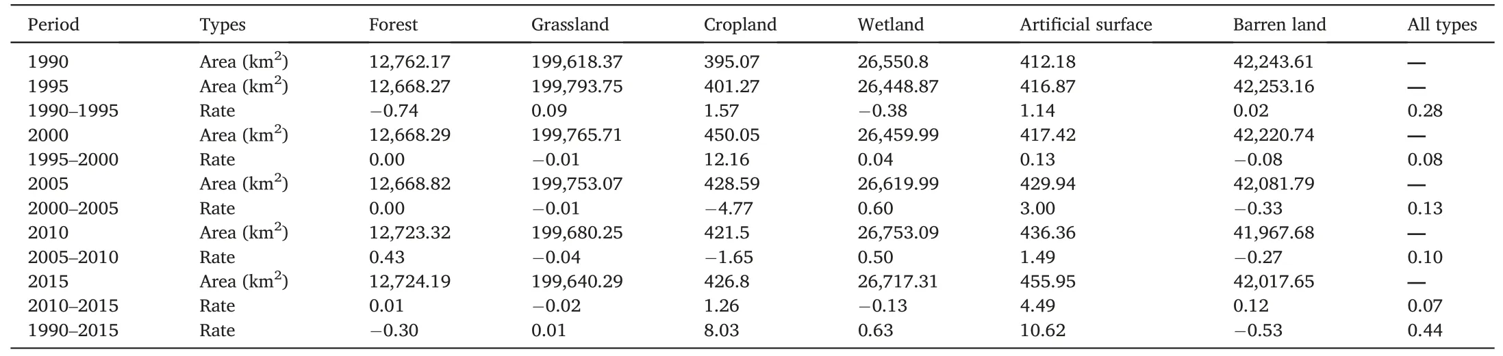
Table 1Ecosystem acreage status quo and net change rate from 1990 to 2015.
The transformation matrix demonstrates that wetland mainly changed from bare land and grassland during 1990–2015.Among them, barren land converted to wetland was mainly distributed in the source region of the YTR, which was the significant ecosystem change, and grassland converted to wetland was mainly distributed in the source region of the YLR(Fig.3).The increase of forest mainly came from grassland,and the decrease of forest mostly transformed into grassland.The increase of grassland mainly came from wetland,while the rest came from forest and barren land.In contrast,the decrease of grassland was mainly transformed into wetland,the rest into farmland,forest land,barren land and artificial surface.Most of the increase in farmland came from grassland.Thedecrease of farmland mainly changed into grassland and artificial surface.The increase of wetland mainly came from barren land, followed by grassland, while the decrease of wetland mainly transformed into grassland, followed by barren land.The change of artificial surface basically increased, mainly from grassland.The increase of barren land change mostly from wetland, followed by grassland, and the decrease of barren land mainly changed into wetland,followed by grassland(Table 2).
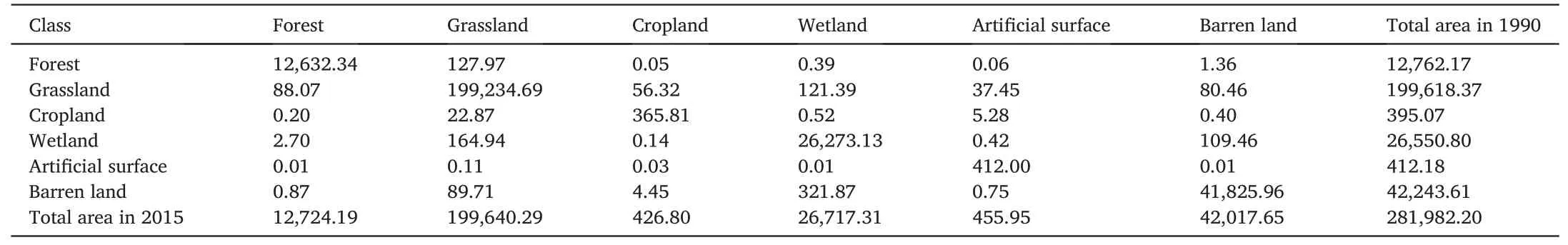
Table 2The ecosystem transfer matrix from 1990 to 2015 (km2).

Fig.3.Change of ecosystems in TRHR from 1990 to 2015.
3.3.Affecting factors of ecosystem change
The ecological and biogeochemical processes are susceptible to climatic variability and anthropogenic activities,and both factors can affect ecosystem change on a regional scale(Jin et al.,2008;Graf,2013;Meng et al., 2020).The increase in precipitation and temperature and ecological rehabilitation caused the vegetation cover and productivity to improve significantly.Climate warming is a decisive factor affecting vegetation growth in TRHR (Li et al., 2011).Since 2000, except for the arid area in the western part of TRHR, most of the other areas have a warm and humid trend (Xu et al., 2012), and it determines the growth trend of vegetation in TRHR.The increase in temperature was the main factor in vegetation growth compared with the increase in precipitation,and temperature plays a more important role in vegetation change in TRHR (Fan et al.,2010;Zhang et al.,2014).
3.3.1.Climate changes
The interval of five years has been used to analyze climate variability in 1990–2015, and the results show that climate change in TRHR exhibited a warming and wet trend for the past decades.The average annual temperature increased from-0.9°C to 0.1°C from 1991 to 1995 to 2011–2015(Fig.3),rising by 1.0°C.The average annual temperature has an increase of 0.22°C/5a.The thawing beginning date shifted to an earlier time,and the freeze start-up date gradually postponed(Liu et al.,2016).Thus,the average number of freeze-thawing days decreased by a rate of three days/10a (Shen et al., 2015).The annual minimum and maximum temperatures also display significant increasing trends (Ding et al.,2018).Climate warming has dramatically changed heat conditions(Bai et al.,2020),and the area with relatively warmer climate will have more significant increases in grassland productivity.As the ecosystem in TRHR is mainly composed of grassland, grassland change made up of most of the ecosystem change (Zhang et al., 2019), and the increase of grassland productivity contributes to improving the overall ecological environment of the region.
Mean annual precipitation significantly fluctuated within the range of 407.0–556.8 mm.Mean annual precipitation is 471.2 mm,and more than 80% of the annual precipitation occurs in the wet season from May to October.TRHR has experienced a significant increasing trend in annual precipitation (Shi et al., 2016).The average annual precipitation has increased from 437.4 mm to 500.3 mm from 1991 to 1995 to 2011–2015,increased by 14.5%(Fig.4),and annual precipitation has an increase of 12.6 mm/5a.The annual reference evapotranspiration(ETo)increase in TRHR was found to be statistically significant, at 5.6 mm/10a for the period of 1961–2016 (Wang et al., 2020).Combining the increase of precipitation and evaporation, the humidity is still increasing in TRHR.The climate will become warm and humid, and more conducive to vegetation growth.Thus, warming and humidity may accelerate the transformation from barren land to grassland and enlargement of wetlands (Zhang et al., 2020), especially in high-elevation areas in central and western TRHR (Fig.3).Moreover, this transformation may accompany more vegetation coverage, biomass and a steadily increasing proportion of vegetation(Pan et al.,2017;Nie et al.,2018;Zhai et al.,2020).
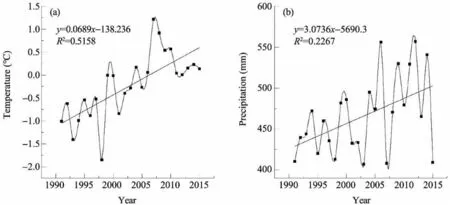
Fig.4.Changes of temperature and precipitation in TRHR from 1990 to 2015.
3.3.2.Human activities
Human activities have an impact on the structure and function of ecosystems (Sun et al., 2020).Human activities that impact ecosystemchanges in TRHR mainly include agricultural production, industrial production, large-scale infrastructure construction and ecological restoration projects (Jia et al., 2020).From 1990 to 2015, the population in TRHR continued to increase,from 436,700 to 732,800,with an increase of 296,100, an increase of 67.8% (Table 3).The continuous rise in the population enhances land-use intensity.Although TRHR has rapid population growth, its urbanization rate is low.Most of the population is concentrated in river valleys,occuping little infrastructure,and change in land use type may be minimal.In this paper, we mainly discuss the impact of animal husbandry and ecological construction projects on vegetation coverage.
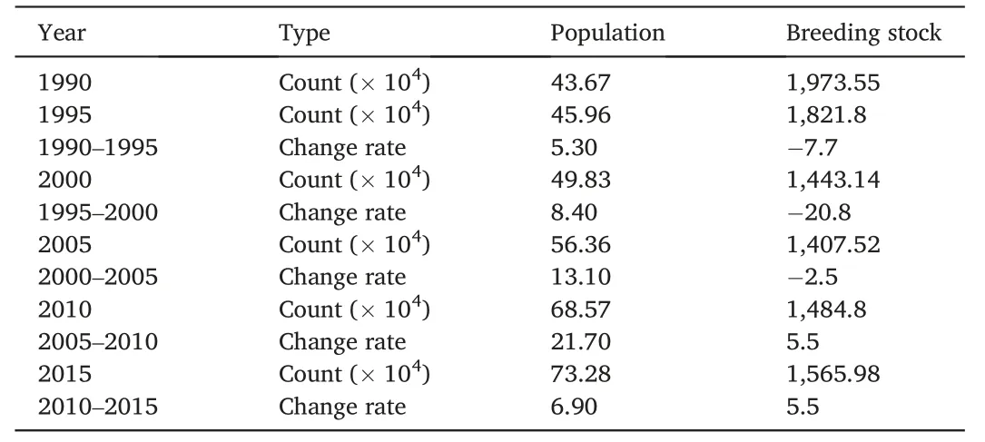
Table 3Changes of population and breeding stock from 1990 to 2015.
Animal husbandry is the leading industry in TRHR, and serious overload led to vegetation degradation.There is a fine line between optimal livestock stocking rate and overgrazing, which could lead to grasslands degradation (Bai et al., 2020).As increased livestock could increase animal consumption of grass biomass and vice versa, livestock numbers could indicate grazing pressure on alpine grasslands.Livestock stock decreased from 19.74 million sheep units to 15.66 million sheep units,a decrease of 20.7%(Table 3).Livestock continued to decline from 1990 to 2005, a decrease of 28.7%, and grazing pressure on the ecosystem has reduced.Although livestock has been rising from 2005 to 2015,by 11.3%,this is only equivalent to 79.3%of the livestock in 1990.Therefore, the impact of human activities on the ecosystem is declining with reduced grazing intensity.The grazing pressure was also largely alleviated by the EPRP due to increased grassland yield and decreased livestock number(Zhang et al.,2017).
The rate of ecosystem change is related to the continued vegetation and ecosystem conservation efforts implemented in the region after 2000.To protect ecosystem functions and allow moderate livestock grazing,the Chinese government established the largest National Nature Reserve in 2003 for grassland vegetation restoration.The project included the restriction of livestock numbers in accordance with regional natural pasture (Bai et al., 2020).The project has proved to have a positive but insignificant effect on vegetation recovery based on the comparison of vegetation changes inside and outside the reserve from 2005 to 2015 (Shen et al., 2018).The Ecological Protection and Restoration Program was initiated in 2005 in the area, and is the largest project for nature reserve protection and reconstruction in the region.This massive effort was expected to improve the tradeoff between grassland productivity and grazing pressure in the area (Zhang et al., 2017).A series of policy measures have been adopted,such as the Sloping Land Conversion Project (SLCP), Grazing Forbidden Conversion Project (GFCP), Natural Forest Conservation Project (NFCP), Three North Shelterbelt Project(TNSP), Three Rivers Headwater Region (TRHR), and Yangtze River Shelterbelt Project (YRSP) (Shao et al., 2013; Jiang et al., 2016; Xiong et al., 2021).These measures have effectively reduced the grazing pressure of regional grasslands, curbed the trend of ecosystem degradation,and improved vegetation growth.
Farmland is mainly distributed in Tongde,Xinghai and Zeku counties,and the area change show a process of rapid increase and sharp decline,then finally remained stable.From 1990 to 2000, the area of farmland rapidly increased and was closely correlated to the rise in population.After 2000, SLCP was implemented, and the area significantly reduced.Since then,the area of farmland in this region has slightly fluctuated.The measures of returning farmlands to forests and grasslands have rapidly reduced the area of farmland from 395.07 km2in 1990 to 426.8 km2in 2015.
4.Conclusions
Evaluating ecological pattern changes in relation to climatic and anthropogenic influences will help ecosystem management and avoid further degradation of the ecosystem function.These evaluations are also essential to test the restoration measures to improve the region's ecological conditions.
The present study used Landsat images and GIS software to monitor the change of ecosystems in TRHR from 1990 to 2015,and analyzed the driving factors behind it in detail.By comparing the acreage changes of forest, grassland, wetland, farmland artificial surface and barren land during 1990–2015, the ecosystem pattern and changes have been evaluated.The change area and change rate of the ecosystem were 1,238.27 km2and 0.44% from 1990 to 2015.Among them, the mutual transformation of wetlands, grassland and bare land is the main characteristics of ecosystem changes, which were mainly distributed in the source region of the Yangtze River and the Yellow River.
Climatic warming and humidification accelerated the transformation from barren land to grassland and enlargement of wetlands.The population increase has less effect on the ecosystem pattern changes.Breeding stock decrease and ecological restoration programs are a significant positive factor that affect ecological quality by improving the vegetation at regional landscapes.
The present study still has limitations.The contribution rate of ecological engineering in driving ecosystem changes has not been quantitatively assessed.More detailed studies,such as ecosystem quality,ecosystem service bio-physical model simulations and actual observation records, are needed to improve our understanding about ecosystem changes.Regional climate models and accurate remote sensing images could also strengthen our understanding of future investigation uncertainties.
Acknowledgments
The authors thank the Geospatial Data Cloud (http://www.gs cloud.cn/), as well as the Chinese Academy of Environmental Science datacenter (http://www.resdc.cn) for providing valuable datasets.The authors are also grateful to Xie Jiali,Xiu Lina and Qian Dawen for their work in data preparation and preprocessing.This work was supported by the Second Tibetan Plateau Scientific Expedition and Research Program(Grant No.2019QZKK0608)and the National Nature Science Foundation of China(Grant No.41730752 and No.41971277).
 Sciences in Cold and Arid Regions2023年2期
- Sciences in Cold and Arid Regions的其它文章
- Long-term feeding of sand rice (Agriophyllum squarrosum seed) can improve the antioxidant capacity of mice
- Relationships between modern pollen and vegetation and climate on the eastern Tibetan Plateau
- Parameter sensitivity analysis for a biochemically-based photosynthesis model
- Temporal and spatial variation of cloud cover in arid regions of Central Asia in the last 40 years
- Editor-in-Chief Yuanming Lai
- Experimental study on mechanical and frost heave behaviors of silty clay improved by polyvinyl alcohol and polypropylene fiber