Spatial distribution and failure mechanism of water-induced landslides in the reservoir areas of Southwest China
Mingling Chen ,Xingguo Yng ,Jiwen Zhou,*
a State Key Laboratory of Hydraulics and Mountain River Engineering,Sichuan University,Chengdu,610065,China
b College of Water Resources and Hydropower,Sichuan University,Chengdu,610065,China
Keywords:Water-induced landslide Hydropower reservoir Spatial distribution Fundamental control Failure mechanism
ABSTRACT Water-induced landslides in hydropower reservoirs pose a great threat to both project operation and human life.This paper examines three large reservoirs in Sichuan Province,China.Field surveys,site monitoring data analyses and numerical simulations are used to analyze the spatial distribution and failure mechanisms of water-induced landslides in reservoir areas.First,the general rules of landslide development in the reservoir area are summarized.The first rule is that most of the landslides have rear edge elevations of 100-500 m above the normal water level of the reservoir,with volumes in the range of 106-107 m3.When the volume exceeds a certain amount,the number of sites at which the landscape can withstand landslides is greatly reduced.Landslide hazards mainly occur in the middle section of the reservoir and less in the annex of the dam site and the latter half of the reservoir area.The second rule is that sedimentary rocks such as sandstone are more prone to landslide hazards than other lithologies.Then,the failure mechanism of changes in the water level that reduces the stability of the slope composed of different geomaterials is analyzed by a proposed slope stability framework that considers displacement and is discussed with the monitoring results.Permeability is an essential parameter for understanding the diametrically opposed deformation behavior of landslides experiencing fillingdrawdown cycles during operation.This study seeks to provide inspiration to subsequent researchers,as well as guidance to technicians,on landslide prevention and control in reservoir areas.
1.Introduction
Landslide is a worldwide issue and has catastrophic results,such as significant property damage and human casualties(Kirschbaum et al.,2015).Reservoir landslides are usually generated through the accumulation of large deformations and have a high potential to form secondary hazards,such as surges,due to the hydrologic setting (Zhou et al.,2017).Landslides caused by naturally formed lakes are mechanistically similar to reservoir landslides,but those occurring in reservoirs need more attention due to the influence of the filling-drawdown cycles of operation (Costa and Schuster,1988).In mountainous areas with high relief,the construction of dams creates reservoirs that affect the stability of the adjacent bank slopes.The effects of man-made lakes are multifaceted.First,they trigger seepage processes that lead to changes in the pore water pressure within the slope and seepage pressure due to possible transient seepage (Song et al.,2015;Xia et al.,2015;Chen et al.,2021).Second,reservoir water creates stabilizing loads at the toe of the inundated slope (Alonso and Pinyol,2010;Paronuzzi et al.,2013,2016).Finally,because the reservoir operates on fillingdrawdown cycles of the water level,the adjacent bank slope material undergoes wet-dry cycles,which in turn leads to strength degradation (Miao et al.,2020;Liao et al.,2021).Therefore,the stability of the bank slope in the reservoir is subject to obvious and frequent changes over time.When considering the long-term effects,impoundment reduces the stability of the slope;however,this reduction may be partially offset by the supporting effect of the reservoir.Under transient conditions,the effect of reservoir water level changes depends on the permeability of the bank slope material and the rate of filling-drawdown.Slope stability can be temporarily improved or deteriorated;the stability must be determined by stability analysis.In addition,reservoir landslides are unfavorable to the safety of hydropower development and operation and may pose greater threats,such as project shutdowns,waves,river blockages and even catastrophic dam breakage accidents,due to the unique environment.The famous events include the 1963 Vajont event and the landslide at the Three Gorges Reservoir (TGR).
Although the Vajont landslide event occurred in 1963,it is still of great interest to researchers and engineers.Compared to other landslide events,the 1963 Vajont event is a tragic memory for the public because of the large economic and social losses,the data continue to be collected and the papers on the subject continue to be published (Müller,1964,1968;Selli and Trevisan,1964;Alonso and Pinyol,2010;Paronuzzi et al.,2013,2016).In China,hydropower development has been elevated to a national policy of clean energy development.Along with the commissioning of the TGR and the continuous development of hydropower in Southwest China,numerous cases of reservoir landslides or related research results have been reported (Yin et al.,2016;Zhou et al.,2017;Chen et al.,2018).
Many studies of reservoir landslides have used various methods and explored different research directions.Most of them have presented hydrologic and geologic models of the slopes of interest and analyses of monitoring results,and some have adopted slope stability evaluation or stress-strain analysis (Qi et al.,2006;Zangerl et al.,2010;Singh et al.,2012;Kaczmarek et al.,2015;Chen et al.,2018;Huang et al.,2018;Zhang et al.,2018).In addition,studies have focused on (i) evaluating the failure occurrence or evolution(Hutchinson,2001;Kilburn and Petley,2003;Zhou et al.,2016a;Li et al.,2020a);(ii)landslide susceptibility mapping(Kumar and Anbalagan,2015;Zhang et al.,2017);(iii) physics modeling experiments (Miao et al.,2018;Jiang et al.,2021);(iv) proposed predictive methods for landslide displacements (Herrera et al.,2009;Bernardie et al.,2015;Troncone et al.,2021);and (v) landslide dynamic analyses or numerical simulations of landslideinduced surges (Sitar et al.,2005;Pinyol and Alonso,2010;Huang et al.,2012;Yin et al.,2015;Zhou et al.,2016b).
Although a considerable number of studies have focused on reservoir landslides,there are still many unanswered questions.For example,the spatial distribution characteristics of landslides in reservoir areas,the deformation characteristics of landslides composed of different materials,the failure mechanisms,and the effect of water level changes on slope stability are all important topics.In terms of spatial distribution,Yin et al.(2016) presented the spatiotemporal distribution of landslides in six fillingdrawdown cycles from 2008 to 2014.Their focus was on a case study of landslide deposits,and the failure mechanism was revealed by monitoring data analysis and numerical simulation.Li et al.(2019a) drew a susceptibility map of reservoir-induced landslides in the Zigui Basin of the TGR.Li et al.(2019b) analyzed the correlation between the spatial distribution and fundamental control on landslides in the TGR.Although they reached consistent conclusions on the effects of slope angle,elevation and lithology on landslide development,whether these conclusions are useful for other reservoirs lacks sufficient discussion.In terms of the effect of water level changes on slope stability,studies such as Paronuzzi et al.(2013),Miao et al.(2018),Chen et al.(2021) and Jiang et al.(2021) focused only on landslides of one material type,which means that the effect of permeability on landslides was not considered.Tang et al.(2019)analyzed and discussed the activity of reservoir landslides with special regard to different permeabilities but there was a lack of correlation analysis of the water level and displacement time series for real cases of landslides with materials of different permeabilities.
In this paper,we present a comprehensive study that includes an analysis of the spatial distribution,a quantitative statistical analysis of the fundamental control on landslide occurrence and a failure mechanism analysis after an on-site investigation of landslides in the Dagangshan Reservoir (DGSR),the Jinping Reservoir(JPR) and the Maoergai Reservoir (MEGR) in Southwest China.Lithology and water level changes are found to be important controlling factors.Analyses of the spatial distribution and correlation with lithology are used to identify the susceptibility of the reservoir areas to landslides and to understand the causes and deformation characteristics of landslides in the reservoir area.This analysis ofsuperficial appearance is achieved by summarizing the commonality of landslide development in the three reservoir areas,comparing this commonality with the TGR,and deriving a general rule for reservoir landslides.For further understanding,the effect of water level changes on slope stability is analyzed by proposing a framework for slope stability evaluation that considers displacement.Therefore,for landslides composed of materials with different permeabilities,the failure mechanism is further revealed by numerical simulation and comparative analysis of monitoring data.Through this study,we hope to provide useful information for reservoir landslide hazard and risk mitigation.
2.Study areas
In Southwest China,three representative reservoirs were selected for the research,as shown in Table 1.
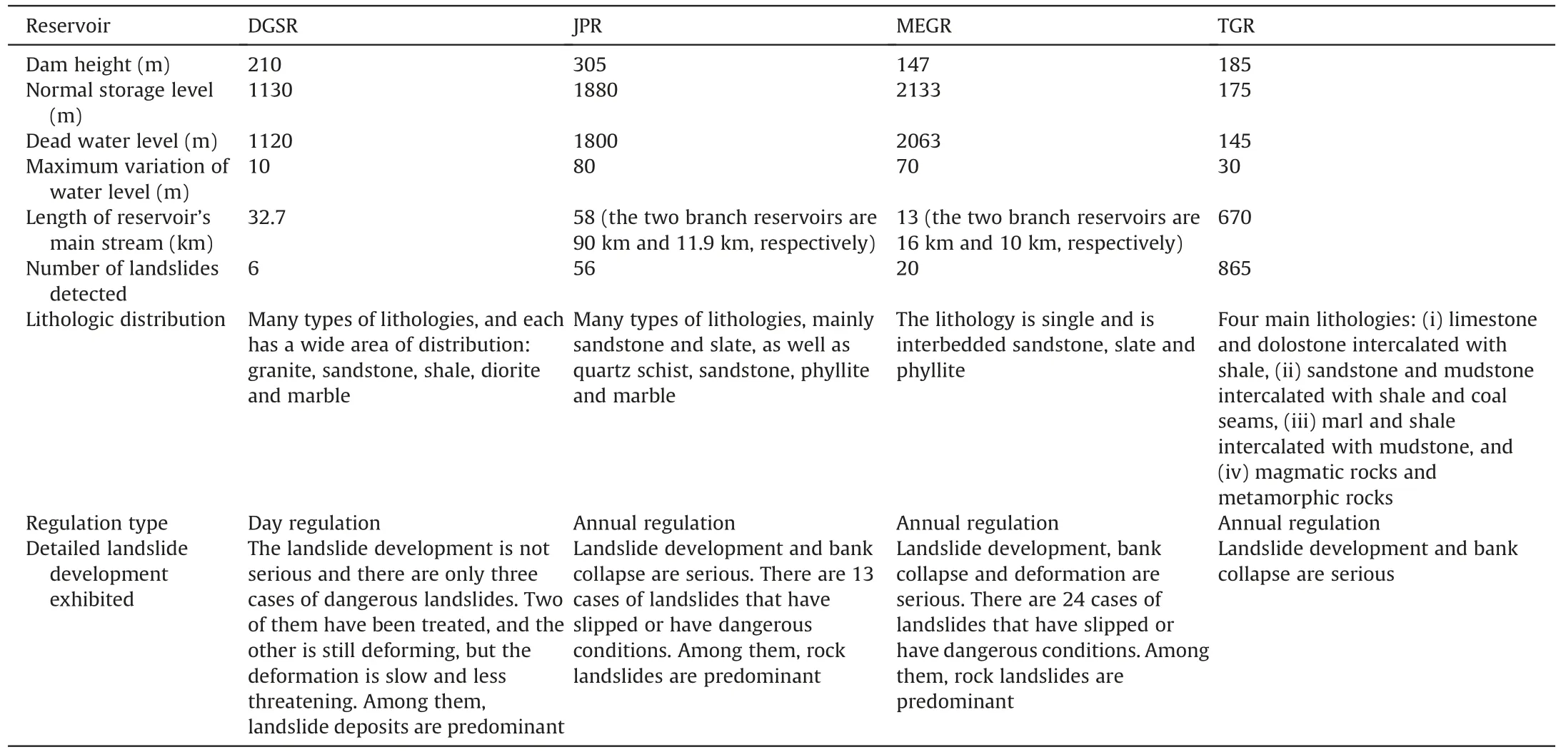
Table 1 Basic parameters and landslide development characteristics of typical hydropower reservoir areas in Southwest China (Li et al.,2019b).
2.1.DGSR
The DGSR is a daily regulated reservoir with a main reservoir length of 32.7 km (the distance here refers to the distance along the reservoir bank),as shown in Fig.1.The classification criteria of landslides by volume are shown in Table 2.The valley is V-shaped,and the slope of the banks above the elevation line at 1600 m is generally less than 35º;below the line,the slope is more than 40º.According to the geology,morphology and tectonics of the reservoir area,the DGSR can be divided into three sections.The first section,which is 0-10.1 km from the dam site,has a curved river channel.The bedrock is mainly granite,which is controlled by intrusive contacts and tectonic structural surfaces,and has a blocky structure.The second section,which is 10.1-20 km from the dam site,has a nearly straight river channel.Two Dadu Riverfracture zones are spread along the main valley,and thin-layer sandstone and shale are developed between them.The eastern side of the fracture zone is composed of granite,and the western side is composed of diorite.The Tianwan River branch reservoir is composed of marble and dolomite,and the rocks mostly have a blocky structure.The third section,which is 20-32.7 km from the dam site,has an open river valley with abundant accumulated deposits on both banks,and the lithological distribution is similar to the second section,but the distribution area of sandstone and shale is smaller.

Table 2 Classification criteria of landslides according to the volume of landslide mass.
2.2.JPR
The JPR is an annually regulated reservoir with a main reservoir length of 58 km,as shown in Fig.2.According to the lithology,structure and morphology of the banks,the main reservoir can be divided into two sections.The first section is 0-28.4 km from the dam site,with slopes of 40º-50º.The bedrock is mostly exposed,and the main lithology is thinly layered sandstone and interbedded slate.Nearer to the dam site,marble is distributed on the eastern side of the river.The second section is 28.4-58 km away from the dam site,and the slope of the bank tends to shallow as it becomes farther away from the dam site.The exposed bedrock is mainly siliceous sandstone,quartz schist and phyllite.There are two branch reservoirs in the Jinping Reservoir area.The Xiaojin River branch starts 18.4 km from the dam site and is 90 km long,with exposed bedrock consisting of sandstone,slate and a small amount of marble.The Woluo River branch is part of the Xiaojin River branch;it starts 83.4 km from the dam site and has a total length of 11.9 km.The bank slope of this river section is 50º-80ºand is locally upright.The bedrock is mostly exposed and consists of sandstone,slate and marble.
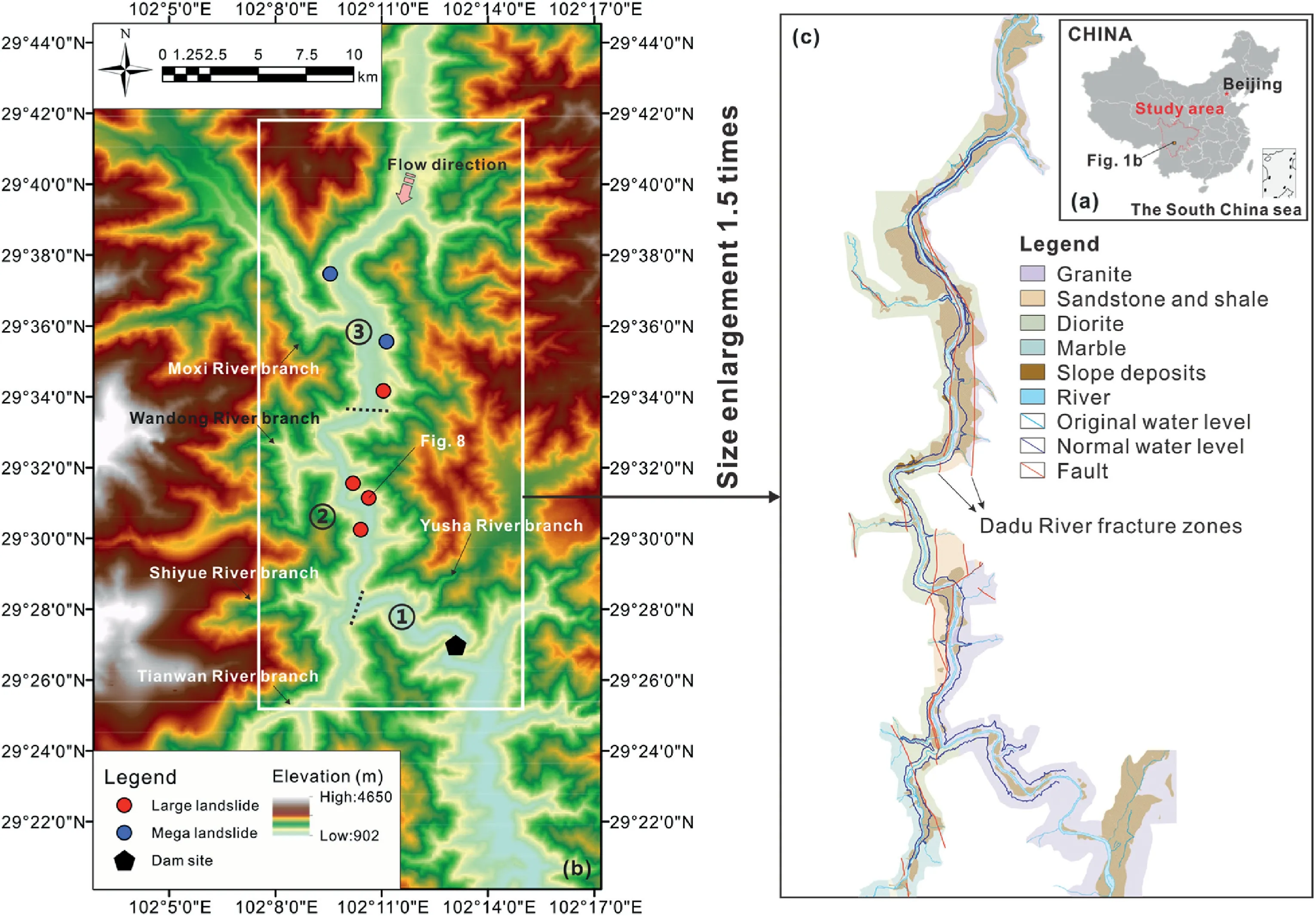
Fig.1.DGSR on the Dadu River: (a) Location,(b) Topographic features with the distribution of reservoir landslides,and (c) Geology.
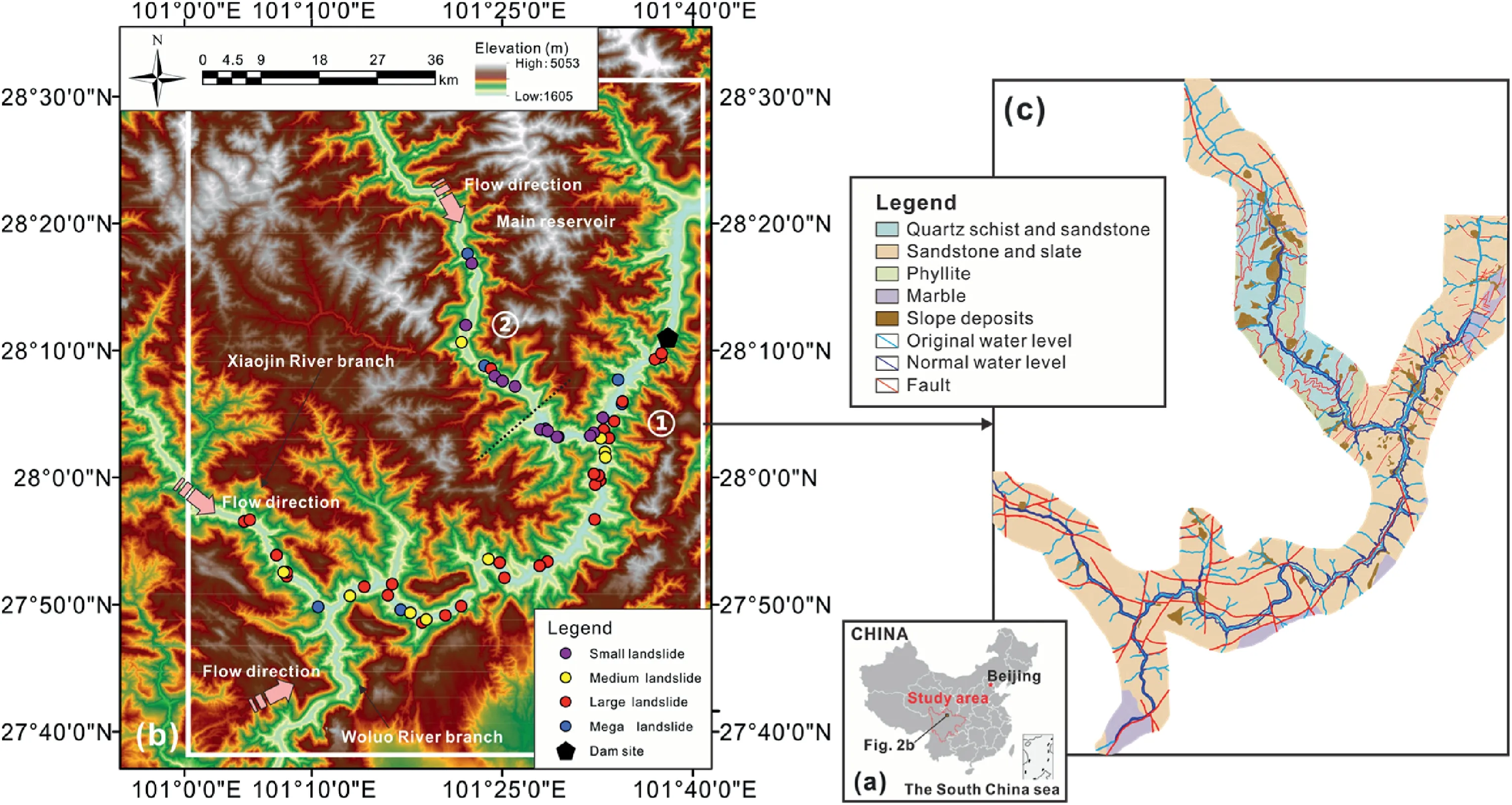
Fig.2.JPR on the Yalong River: (a) Location,(b) Topographic features with the distribution of reservoir landslides,and (c) Geology.
2.3.MEGR
The MEGR is an annually regulated reservoir with a main reservoir length of 13 km,as shown in Fig.3.The MEGR consists of the Heishui River main reservoir and two branch reservoirs.The Heishui River main reservoir is approximately 13 km long;the Maoergai River branch reservoir and the Xiaoheishui River branch reservoir are approximately 16 km and 10 km long,respectively.The Heishui River main reservoir is characterized by a U-shaped valley,the slopes of the banks are generally 45º-65º,and the slope deposits at low elevations lie at angles of approximately 20º-35º.The Maoergai River branch reservoir is characterized by a curved channel.The section near the dam site is a narrow U-shaped valley,and the slopes of the banks are generally 50º-70º.Farther from the dam,it becomes an asymmetric U-shaped valley,with banks sloping generally 45º-60º,and slope deposits at low elevations lie at angles of approximately 15º-45º.The Xiaoheishui River branch reservoir is a V-shaped valley.The exposed bedrock in the reservoir area is mainly metamorphic rocks with large thickness variations,and the lithology is interbedded quartz sandstone,slate and phyllite.
3.Spatial distribution and fundamental control
3.1.Data preparation
The causes and forms of slope deformation are complex,and many definitions of landslides are parallel or overlapping (Hungr et al.,2014).As shown in Fig.4,to better understand and analyze landslides caused by the presence of reservoirs,the deformation of slopes that occurs in reservoirs due to water storage is divided into five categories: (i) rockfall;(ii) bank collapse,which mainly refers to the collapse of slopes attached to riparian zones by washout,abrasion and toe erosion;(iii)gravitational deformation lacking a fully defined rupture surface,such as toppling deformation;(iv) landslide,which is a type of gravitational deformation with a well-defined rupture surface;and (v) runoffgenerated debris flow in gully channels.This classification is based on the research of Schuster (1979) and Hungr et al.(2014),as well as previous engineering experience and knowledge gained from geological hazard investigations in the three reservoirs.The subject of this research is landslides caused by the presence of reservoirs (specifically referring to the fourth category).Based on their material composition,landslides can be divided into landslide deposits (landslides in Quaternary and earlier deposits) and rock landslides (landslides in rock masses).
Data on landslides are recorded via field investigations and geohazard reports published by the local survey and design institute in Sichuan Province.The topographic presentation of the study areas is based on ArcGIS imagery and digital elevation model(DEM)data with 90-m accuracy provided by SRTM3.The locations of landslides are determined by comparing site photos and satellite images.This section presents the spatial distribution characteristics of landslides in the reservoir areas and their correlation with lithology.The slope angle is a common control factor that can also be obtained by analyzing the DEM.However,a series of field investigations revealed that there may be variations in the surface of a large-magnitude landslide;therefore,the slope angle is not the focus of this paper.
To verify the general rule derived from the three reservoirs,this paper conducts a landslide comparison in the TGR.However,different researchers disagree on the total number of landslides in the TGR,with totals of 2490,328 and 865 from Li et al.(2019a),Tang et al.(2019)and Li et al.(2019b),respectively.The study of Li et al.(2019b) is chosen for comparison because it focuses on the spatial distribution of landslides in the TGR and the main controlling factors.
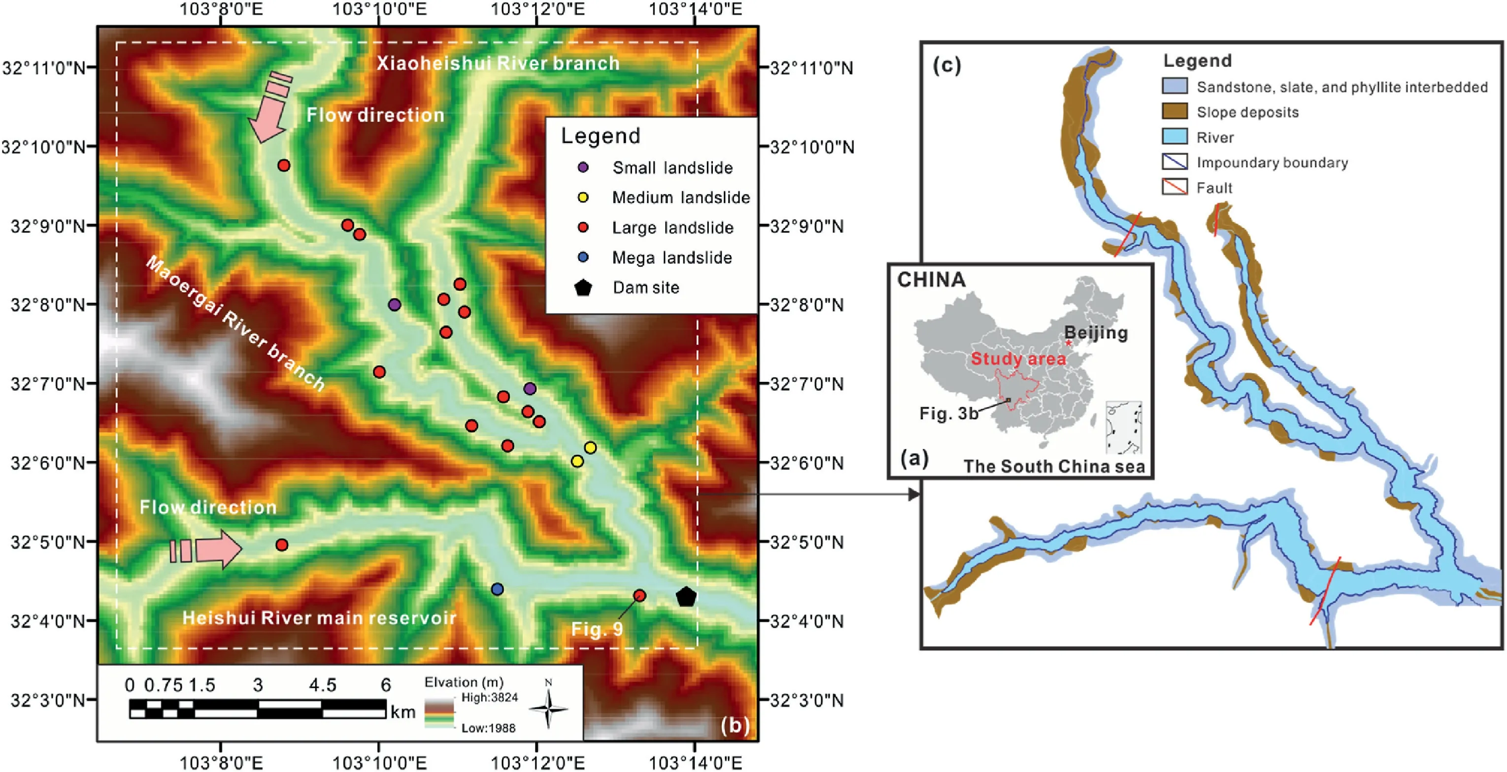
Fig.3.MEGR on the Heishui River: (a) Location,(b) Topographic features with the distribution of reservoir landslides,and (c) Geology.
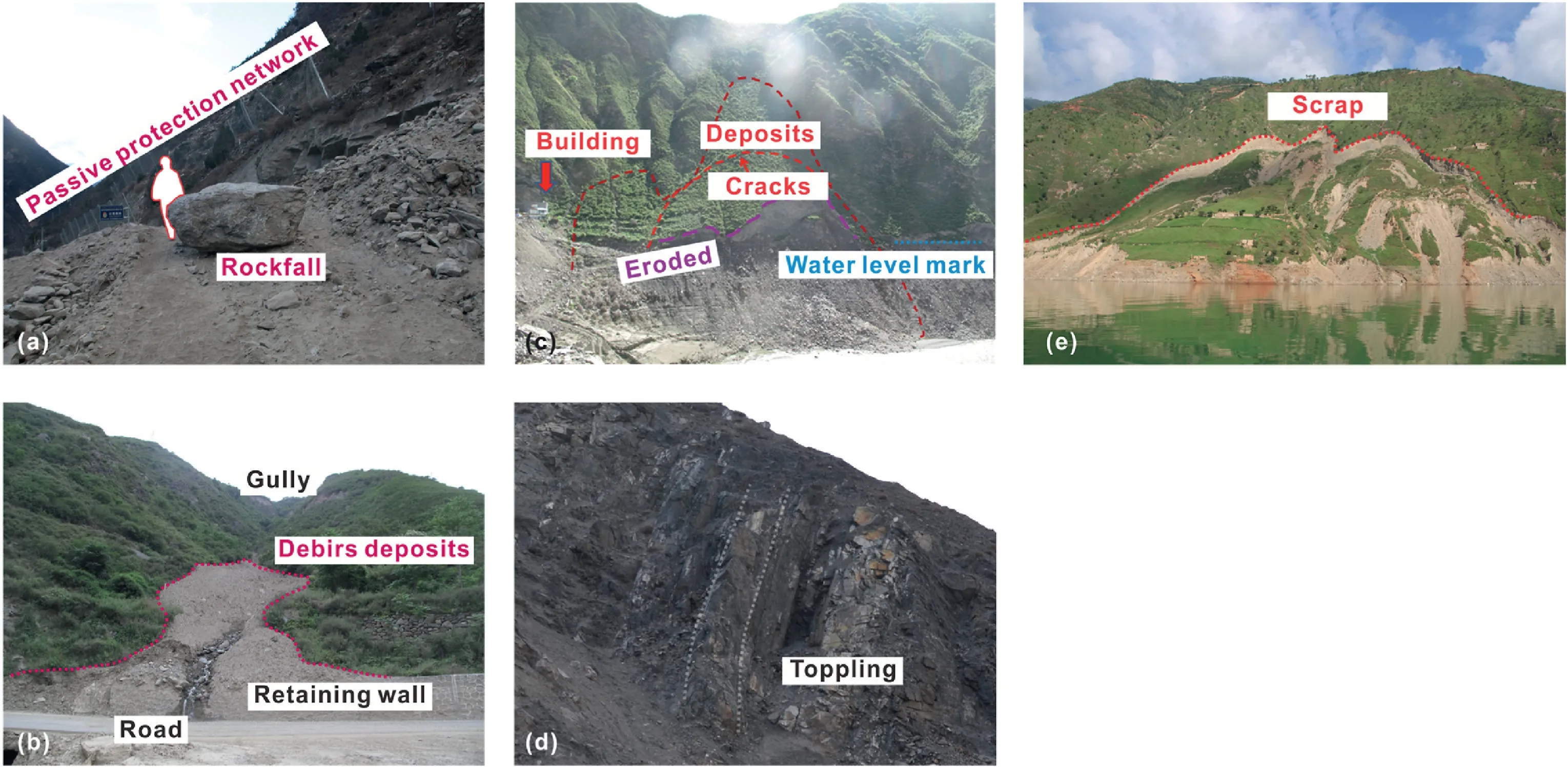
Fig.4.Types of slope gravity deformation: (a) Rockfall,(b) Debris flow,(c) Bank collapse,(d) Toppling deformation,and (e) Landslide.
3.2.Distribution and magnitude of landslides
The front edge elevation of landslides chosen for this study is located below the normal water level line,thus this paper examined the spatial distribution of landslides in the reservoir area based on the elevation difference between the rear edge elevation and the normal water level line.As shown in Fig.5a,most of the elevation differences between the rear edge elevation and the normal water level line of the landslides in the three reservoir areas are concentrated between 100 m and 500 m.This feature is similar to that of the TGR,where most of the rear edge elevations are concentrated within 200-600 m,while the elevation of the normal water level line is 175 m (Li et al.,2019a,b).At the elevation of 500 m above the water surface line,few landslides are distributed.However,there are also many landslides located below the normal water level in the JPR.The reason for these data is that during the survey of potential geological hazards before reservoir impoundment,landslides below the normal water level were also counted in the JPR.
The magnitude of the landslide is expressed by volume.As shown in Fig.5b,the volume range of all the included landslides spans six orders of magnitude,from 103m3to 108m3.Very few landslides have volumes less than 104m3or greater than 108m3.The volumes of the vast majority of landslides in the three reservoirs are concentrated in the range of 106-107m3.The magnitude cumulative frequency analysis is derived by ranking all landslides in order of increasing volume and accumulating incremental frequencies from the largest to the smallest(Hungr et al.,1999).Fig.5c shows the cumulative frequency-volume distribution of landslides in the three reservoir areas.In addition,for volumes larger than the rollover volume at the inflection point,the distribution behaves as an inverse power law function,with the distribution changing direction for smaller volumes on a log-log scale.The number of landslides in the DGSR is small and is not fitted to this distribution.The slope of the straight line is plotted with the power law scaling exponents in the JPR and MEGR,and it fits the data well.The power scaling exponents of the MEGR characterized by all rock landslides are greater than those of the JPR,but the maximum volume is smaller.The power scaling exponents of landslides in the two reservoirs are very close to the observations of Tsou et al.(2017).
Concentration describes the density of the spatial distribution of landslides in an area and is obtained by dividing the number of landslides by the length of the bank slope.The mean landslide concentrations for the DGSR,JPR and MEGR are 0.18,0.35 and 0.51,respectively.The average landslide concentration in the TGR is 0.752 per km,which is significantly higher than that in the three reservoir areas of concern in this paper (Li et al.,2019b).The differences may be related to the different bases of the inventory statistics.After considering the volume of the landslide,the mean landslide volume concentrations are 208.87,137.87 and 190.35,in that order.The landslide volume concentration of the DGSR is too high because the residual masses of the Mogangling landslide and Lantianwan landslide triggered by the 1786 MoxiM=7.75 earthquake were counted during the statistical process to maintain conservative reservoir safety,and their volumes reached an order of magnitude of 107(Zhao et al.,2021).However,no deformation of these two landslide residuals was detected during the deformation monitoring and observation.The landslide volume concentrations of dangerous landslides were further counted with specific values of 30.58,53.49 and 57.12,respectively.As shown in Fig.5c,for the MEGR,there is a significant decrease in the number of landslide sites when the landslide volume is greater than 106m3.For the JPR,this number is 1.3 × 10⁶m3.Therefore,the mean landslide concentration in the JPR is smaller than that in the MEGR,and the mean landslide volume concentration is larger.
Fig.6 shows the results of the analysis of the cumulative frequency versus the distance from the dam site.The three reservoir areas show a consistent pattern.The development and occurrence of landslide hazards are less at a close distance from the dam site.As the distance increases,the frequency of landslide hazard development and occurrence show a pattern of rapid increase followed by gradual slowing.This is because the slope angle of the riverbed in the reservoir area along the river direction is not equal to 0.This impacts the whole process,including the water level rising from the original water level to the normal water level and then fluctuating between the normal water level and the dead water level,to varying degrees in different locations in the reservoir area.There is a tendency for the impact to weaken as the distance increases.At the same time,safety considerations in dam site selection,as well as slope management in the dam site area annex before hydropower plant impoundment,result in fewer landslide hazards close to the dam site.This pattern can also be observed via the same phenomenon in the TGR.Water level change,as a fundamental control,is also a direct cause of landslides,and the specific disaster mechanism is presented later.
3.3.Lithological differences
As shown in Fig.7,landslides are present in the three main lithologies,except for marble,in the DGSR(diorite:16.67%;granite:33.33%;sandstone and shale: 50%;marble: 0%),but all the dangerous landslides with large deformations exist in the sandstone and shale(100%).In the JPR,no landslide is located in the area where its main lithology is marble,and the landslides occurs in the remaining three lithologies (phyllite: 5.36%;quartz schist and sandstone: 14.29%;sandstone and slate: 80.36%;marble: 0%).The dangerous landslides basically occur in the areas where sandstone slate is predominantly developed (100%).Since there is only one major lithology (quartz sandstone,with interbedded slate and phyllite)in the MEGR,there is only one type of lithology.Analysis of the correlation between the spatial distribution of landslides and lithology reveals that the lithology of the areas with the highest number of developed landslides and the most severe landslide deformation is characterized mainly by sandstone.This may be related to the low strength and poor water resistance of sedimentary rocks,such as sandstone,compared to marble,and plutonic metamorphic rocks,such as granite and diorite.
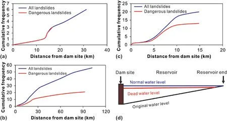
Fig.6.Landslide cumulative frequency versus distance from the dam site in the landslide inventory:(a)DGSR,(b)JPR,(c)MEGR,and(d)Schematic diagram of the reservoir.Note that ‘dangerous’ refers to the landslides with large deformation that has been monitored or vertical offset of the rear edge cracks.
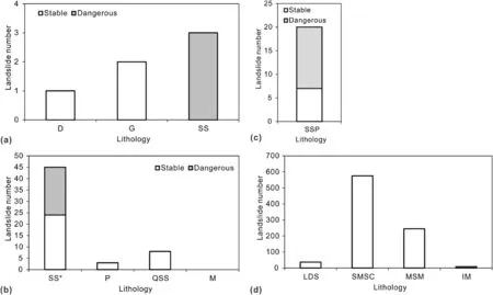
Fig.7.Landslide distribution characteristics of different lithologies in the landslide inventory:(1)DGSR,(2)JPR,(3)MEGR,and(4)TGR(Li et al.,2019b).Note that‘stable’refers to the landslides with no large deformation that has been monitored or no vertical offset of the rear edge cracks;‘D’refers to diorite;‘G’refers to granite;‘SS’refers to sandstone and shale;‘SS*’refers to sandstone and slate;‘P’refers to phyllite;‘QSS’refers to quart schist and slate;‘M’refers to marble;‘SSP’refers to sandstone,slate and phyllite;‘LDS’refers to limestone and dolostone intercalated with shale;‘SMSC’refers to sandstone and mudstone intercalated with shale and coal seams;‘MSM’refers to marl and shale intercalated with mudstone;and ‘IM’ refers to magmatic rocks and metamorphic rocks.
There are four main lithologies in the TGR (Li et al.,2019b).Among them,the sandstone and mudstone intercalated with shale and coal seams are the lithologies with the highest proportion of landslides(66.5%),and the lithologies with the lowest proportion of landslides(0.9%)are magmatic rocks and metamorphic rocks(such as granite,amphibolite,gabbro and gneiss).Although the four lithologies in the TGR differ in the proportion of their distributed area,i.e.sandstone and mudstone intercalated with shale and coal seams have the largest distribution area,the difference in the proportion of developed landslides is extremely large (limestone and dolostone intercalated with shale: 4.3%;marl and shale intercalated with mudstone: 28.3%).Based on this difference,the general lithologic rule shown in the three reservoirs of Southwest China also agrees with that in the TGR.In other words,the most serious landslide hazards occur in the lithology that dominantly contains sedimentary rocks,such as sandstone.
4.Failure mechanism analyses
4.1.Deformation response patterns
Displacement monitoring is the most direct way to understand the deformation of slopes,and the common components are(i)the time series of surface point displacements obtained by global navigation satellite systems (GNSSs) or total stations (Chen et al.,2018,2020,2021;Zhang et al.,2020) and (ii) the accumulation of slope deformation in space obtained by noncontact measurement techniques,such as terrestrial laser scanning (Barbarella et al.,2015;Li et al.,2020b).Because of the special hydrological conditions of water-induced landslides,it is necessary to analyze the correlation between the time series of the cumulative displacement data and the reservoir water level.In this study,the water level data were provided by hydropower development companies in their respective study areas,and the displacement data were obtained by GNSS or total station recording.
Water level change is one of the fundamental controlling factors and the direct cause of slope deformation or landslide occurrence.Analyzing the correlation with the displacement time series helps to understand the failure mechanism of the reservoir area.During the process of understanding the displacement of the reservoir landslide,two deformation response patterns of the reservoir landslide are found in the filling-drawdown cycles during the operation period.These two landslide cases were chosen because(i)they have a complete record of the displacement and water level since pre-impoundment;(ii) they can represent two deformation response patterns;and (iii) one is a landslide deposit in the DGSR and the other is a rock landslide in the MEGR.These two hydropower stations have different ways of regulating the water level;the DGSR is regulated daily,and the MEGR is regulated annually.The overhead view and monitoring section of the geology and topography of the landslide deposit are shown in Fig.8,and those of the rock landslide are shown in Fig.9.The landslide deposit in the DGSR is 14.6 km from the dam site and is distributed between 1065 m and 1420 m in elevation.A fracture zone is developed in each of the east and west directions of the landslide deposit.The lithology of the two fracture zones is granite on the eastern side and diorite on the western side,with sandstone and shale in planar structures between them.The composition of the landslide deposit has two parts: the colluvium above an elevation of~1300 m and the ancient landslide deposit below an elevation of 1300 m.Alluvium is distributed below the front edge of the landslide deposit.The rock landslide is~500 m from the dam site and is located on the right bank of the reservoir.The lithology is characterized by interbedded sandstone and phyllite.The landslide originates from toppling deformation due to shallow strength reduction and stress concentration in the slope toe.Due to the fragmentation of the surface rock on the slope where the landslide is located and its proximity to the dam site,the slope between 2155 m and 2250 m was excavated,concrete was sprayed,and anchor bolts were arranged during the feasibility design phase of the hydropower station.
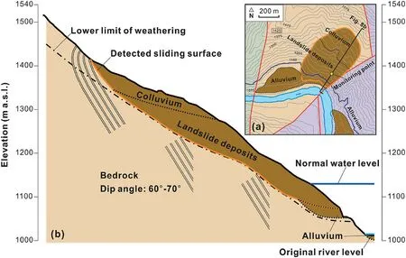
Fig.8.Geological map(a)and cross-section(b)of a landslide deposit in the DGSR.The unit ‘m a.s.l.’ means meter above sea level.
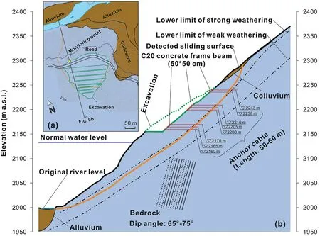
Fig.9.Geological map (a) and cross-section (b) of a rock landslide in the MEGR.
The specific laws of the two deformation response patterns can be obtained from the comparison of the water level and displacement time series,and then the factors influencing each response pattern are analyzed,as shown in Fig.10.The time series is divided into two periods: the impoundment period,which encompasses the time period of the first substantial water level rise,and the operation period,which encompasses the time characterized by filling-drawdown cycles.During the impoundment period,the landslides composed of both materials exhibit the same response pattern.The DGSR began impoundment on 23 May 2015(when the water level was 1013.47 m),and was completed in December 2015,reaching 1129.73 m for the first time.During this time period,the monitoring point on the landslide deposit moved 8297.9 mm toward the riverbank along the monitoring section line in the overhead view plane.The MEGR began impoundment on 20 March 2011,and reached the normal water level of 2133.21 m in October 2012.During this time period,the rock landslide moved 769.8 mm toward the riverbank.With the first substantial rise in the water level,the movement rates of the landslides composed of both materials showed a positive correlation with the water level and generated a large displacement.Regarding the landslide deposits in the DGSR,the increase in the landslide movement rate lags behind the rise in the water level.This is because the permeability of the deposit is low,resulting in the water level rising after reservoir water infiltration,thereby raising the groundwater level,which causes the change in the reservoir water level to lag,and further causes the deformation response to lag.After entering the operation period,the deformation response patterns of the landslides composed of two material show differences.For the landslide deposit,the movement rate shows a negative correlation with the water level.The increase in displacement occurs when the water level decreases,and the subsequent rise in the water level inhibits its occurrence.However,not all water level decreases lead to deformation,and the occurrence time coincides with the flood season.For the rock landslide,although the anchor cables and concrete frame beam were installed in October 2011,deformation was still developing.The deformation response pattern of the rock landslide shows a positive correlation with the water level.When the water level rises,the movement rate increases;when the water level decreases,the movement rate decreases.The deformation response patterns of the landslides composed of different materials in the Southwest China reservoir area are also similar to those of landslides in other reservoirs,as shown in Table 3.
Further observation of the time series of displacements reveals that both landslide cases have a tendency for the deformation to converge.The DGSR is a daily regulating reservoir,in which several filling-drawdown cycles occur in a year.The landslide deposit deformation is induced by a significant rise in the water level during the impoundment period and the drawdown of the water level during the flood period in the operation period.As shown in Fig.10a,the magnitude of the three deformations gradually decreases in the time series shown.The MEGR is an annual regulating reservoir characterized by one filling-drawdown cycle per year.The deformation of rock landslides is mainly caused by the rising water level.As shown in Fig.10c,the magnitude of the four deformations gradually decreases in the time series shown.Thus,as deformation accumulates,the slopes tend to gradually approach stability in the absence of new external loads.For the 1963 Vajont landslide,the maximum height of the water level rise was different for the three cycles in the order of 652 m,700 m and 710 m.Although there is also a tendency for the deformation to converge,finally,in the third water level rise,a mutation in the movement rate occurs,causing the occurrence of the landslide.
4.2.Numerical interpretation
The effect of water level changes on the stability of partially submerged slopes depends on a variety of factors,such as material properties(mainly hydraulic conductivity function and the soil water characteristic curve),slope geometry,initial pore water pressure distribution,rate of water level change,and initial and final locations of the reservoir water level.Of these,permeability is considered to be the most important factor in addition to shear resistance strength(cohesion and angle of internal friction),which determines the timedependent location of the groundwater table during water level changes and further triggers hydraulic changes.To further understand the influence of water level changes and the accumulation of displacements on slope stability,numerical simulations were conducted through the method expressed in Appendix A(Yi et al.,2017).The method used in this study evaluates the slope stability by introducing the virtual displacement and using the energy method.Compared with the limit equilibrium method,its advantages are as follows:(i) if the virtual displacement is regarded as a variable,the effect of displacement on slope stability can be studied;(ii) if the factor of safety(FOS)for the slope is less than 1,the dynamics after instability can be further calculated using the energy balance.In this study,the first advantage is mainly utilized.The validation of the method is presented in Appendix B.Usually,the slope stability with groundwater variations is analyzed by uncoupled analysis,and the hydraulic results obtained by the finite element method are imported into the framework and calculated.In the absence of an effective means of importing the results of the finite element method to the framework,reasonable assumptions regarding patterns of groundwater changes are feasible based on the monitoring results of landslides with different permeabilities,as shown in Fig.11(Alonso and Pinyol,2010;Segui et al.,2020).
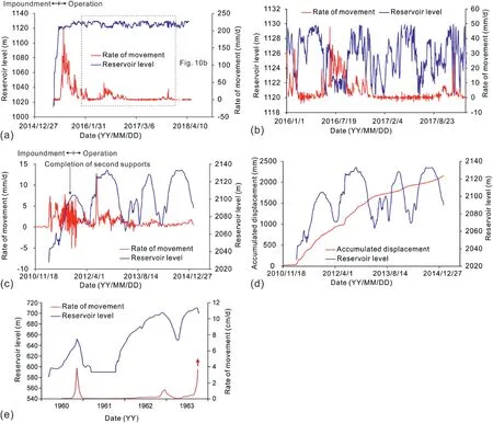
Fig.10.Deformation performance of landslides and correlation with water level changes: (a) Since the start of impoundment for the landslide deposit in the DGSR,(b) In the operation period for the landslide deposit in the DGSR,(c)Movement rate of the rock landslide in the MEGR,(d)Accumulated displacement of the rock landslide in the MEGR,and(e) The 1963 Vajont landslide (Paronuzzi et al.,2013).
When the water level changes,the possible presence of internal pore water pressure,hydrostatic pressure on the toe of the slope,and seepage force due to water level differences can lead to a new limit equilibrium,as shown in Fig.12.For low-permeability materials,there is a situation in which the equipotential line of flow is not vertical,thus it needs to be corrected for pore water pressure.The following equation is used for correction:

whereHwis the vertical distance from the base center of the slice to the piezometric line,Hcis the pore pressure at the base center of the slice,and β is the angle between the piezometric line and the horizontal direction.
Bear (1972) explained that the seepage force can be calculated by

where γwis the unit weight of water,Asatis the area of the saturated zone,and ΔHis the difference in the water level within the side slope.
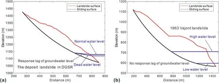
Fig.11.Reasonable assumptions of the variation in the patterns of groundwater levels in landslides with different materials:(a)The landslide deposit in the DGSR,and(b)The 1963 Vajont landslide.
The geological profiles of the landslide deposit in the DGSR and the 1963 Vajont landslide were selected for calculation.As shown in Fig.13,the results show that for highly permeable materials,the safety factor of the slope decreases as the water level rises.This is due to the increase in the pore water pressure inside the slope caused by the elevated groundwater table,which decreases the effective stress on the slice bottom and thus the slip resistance.The calculated results are consistent with Alonso and Pinyol(2010)and Paronuzzi et al.(2013).For low-permeability materials,the safety factor of the slope decreases as the water table decreases.This is because the groundwater level drop lags behind the reservoir water level drop,leading to the appearance of transient seepage and infiltration pressure,and thus the slip force increases.For both materials,the slope stability increases with the accumulation of displacement,as shown in Fig.13b and d,which indicates that the movement of the landslide is a self-stabilizing process.This result regarding the influence of displacement on the slope stability is also consistent with that of Alonso and Pinyol (2010).
5.Discussion
After investigating the reservoir landslides that occurred at the Grand Coulee dam from 1941 to 1953,Jones et al.(1961)found that approximately half of the landslides occurred during filling operations and approximately 30% occurred during drawdown operations.Nakamura(1990)investigated historical cases in Japan and found that approximately 60%of reservoir landslides occurred when the sudden drawdown of water level occurred and that another 40%occurred when the water level rose.Riemer (1992) found that in a study of 60 reservoir landslides,85% of the landslides occurred within two years of the impoundment period after the completion of the project.ICOLD (2002) stated that,based on statistics of 100 landslides associated with 50 reservoirs in six countries,70%of the landslides were characterized by the reactivation of ancient landslides.By investigating the landslides in the reservoir area of Southwest China,this study further finds that the development of reservoir landslides is closely related to material permeability.
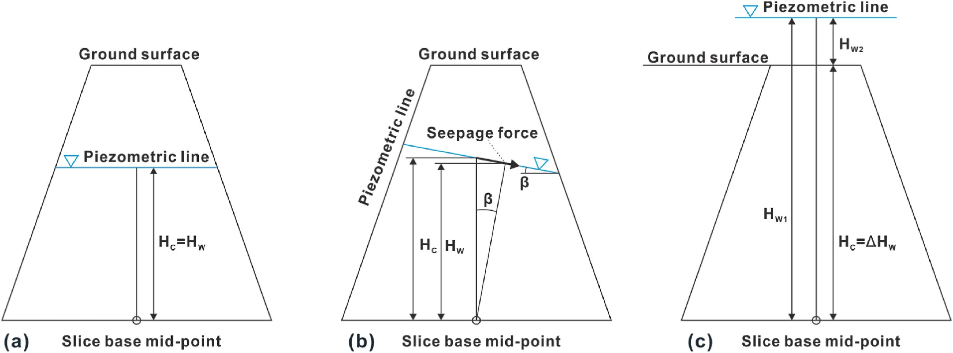
Fig.12.Treatment of the slices in different water level situations:(a)Horizontal groundwater level,(b)Groundwater level at an angle to the horizontal,and(c)The slice inundated by reservoir water.
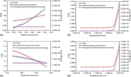
Fig.13.Results of slope stability calculations:(a)Correlation with the water level for the DGSR landslide deposit,(b)Correlation with the water level for the 1963 Vajont landslide,(c) Correlation with the displacement for the DGSR landslide deposit,and (d) Correlation with the displacement for the 1963 Vajont landslide.
Simplified stability analyses have been performed to quantitatively evaluate the effect of water level fluctuations on slope stability for specific scenarios.These stability analyses did not consider the actual seepage processes within the slope but rather are evaluations of the landslide potential based on reasonable assumptions about the groundwater table for materials with different hydraulic conductivities.Despite the inherent limitations of this modeling approach,it provides useful information to understand different response patterns of landslides with different materials in the filling-drawdown cycles during the operation period.To ensure the accuracy of the conclusions,some cases with realistic groundwater monitoring or numerical simulations are discussed.
Kenney (1992) attempted to provide an explanation for the hydrogeological mechanism of the effect of reservoir water level changes on slope stability and found that permeability influences the pattern of change in the safety factor.In the case of numerical simulation studies of materials with different permeabilities,a different conclusion is presented about the relationship between slope stability and water level variation.For landslide deposits(low permeability),the safety factor and water level change are negatively correlated (Song et al.,2015;Chen et al.,2021);for rock landslides (high permeability),the safety factor and water level change are positively correlated(Paronuzzi et al.,2013).Tang et al.(2019) studied the effect of the water level change (at a rate of 0.6 m/d)on slope stability at different permeabilities(with a value range of 0.02-20 m/d).They attributed the decrease in the stability of landslides with high-permeability materials during water level filling to buoyancy and the decrease in the stability of landslides with low-permeability materials during water level drawdown to seepage pressure.
Chen et al.(2018) investigated the deformation process of the same landslide deposit from the DGSR that was also examined in this study and identified the deformation mechanism,as shown in Fig.14.Zhang et al.(2020) simultaneously recorded the deformation and pore water pressure process of the Majiagou landslide deposit in the TGR,verifying the deformation mechanism of the landslide deposit inferred by Chen et al.(2018),as shown in Fig.15.For landslide deposits characterized by low permeability,when the water level drops rapidly or when rainfall and drawdown of the water level occur simultaneously,the presence of transient seepage leads to seepage pressure as the main contribution to the deformation or landslide occurrence.
For the 1963 Vajont landslide,Selli and Trevisan(1964)were the first to perform a monitoring study of the groundwater level and deformation prior to a catastrophic landslide on the Mt.Toc slope.Later,Paronuzzi et al.(2013)provided an integrated understanding of hydrological and geological models of this landslide,as shown in Fig.16a.In late 1962,the groundwater measured inside the slope almost simultaneously followed the changes in the reservoir level.However,the groundwater level increased after the occurrence of heavy rainfall.This finding indicates that the landslide mass is characterized by high permeability.The rock landslide in the MEGR was also monitored for groundwater levels,as shown in Fig.16b.Records of groundwater levels show similar characteristics to the 1963 Vajont landslide,which is made up of high-permeability materials.The groundwater level can change over time when the reservoir level changes,which means that it is close to steady-state seepage.Therefore,the reduction in effective stress by increasing the water level is the key to understanding the failure mechanism of rock landslides characterized by high permeability.
The above discussion can explain the kinematic mechanism of landslides composed of different materials experiencing fillingdrawdown cycles,but only during the operation period.When the water level rises rapidly,for low-permeability materials,the groundwater level changes with a response lag and a seepage pressure whose direction is favorable to the slip resistance,which cannot explain the deformation behavior of the slope during the water storage period.The degradation of strength by water is considered as the cause.Some experimental results have shown that when the shallow earth is sufficiently soaked,the shear strength is irreversibly degraded and will no longer change (Deng et al.,2017;Jiang et al.,2019;Liao et al.,2021).
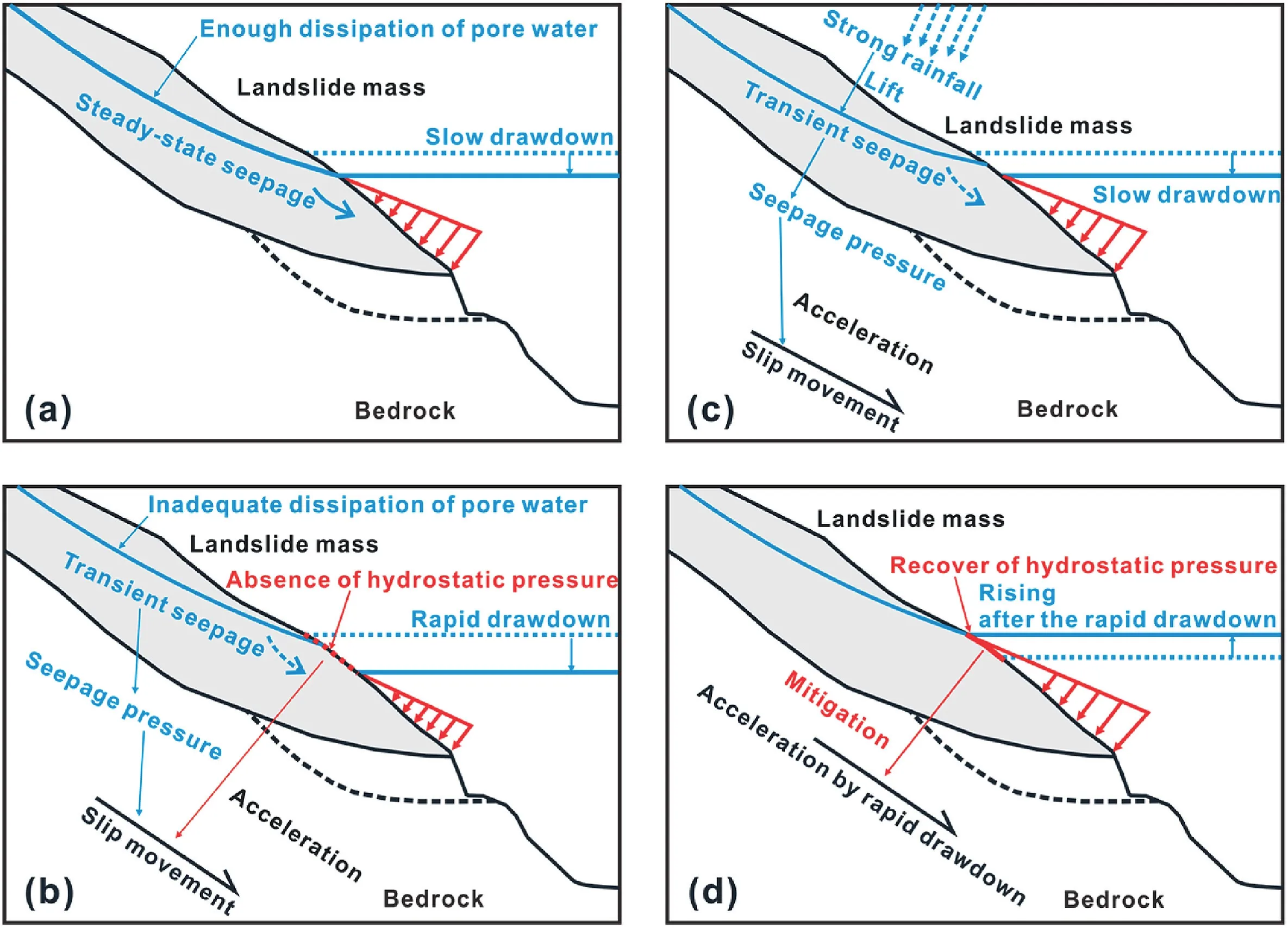
Fig.14.Response mechanism of the landslide deposit in the reservoir during filling-drawdown cycles:(a)Slow drawdown of the water level,(b)Rapid drawdown of the water level,(c) Slow drawdown of the water level with strong rainfall,and (d) Increase in the water level after rapid drawdown.
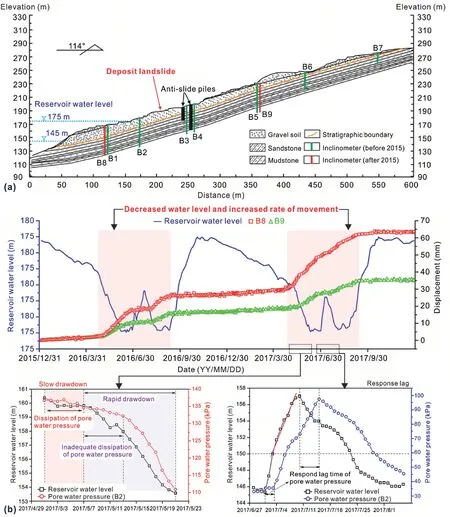
Fig.15.Monitoring results of a landslide deposit in the TGR (Zhang et al.,2020): (a) Geological cross-section,and (b) Reservoir water level and movement.
6.Conclusions
To transform hydraulic resources into resources of economic value,the construction of a large number of hydropower projects has inevitably led to dramatic changes in the hydrological and geological environment of the high-relief mountainous regions of Southwest China.As hydropower development in Southwest China continues to advance,numerous cases of reservoir landslides have been reported.The lessons of the 1963 Vajont landslide event are still relevant.Avoiding human casualties and property damage has become a top priority for hydropower development projects.
Understanding the spatial distribution characteristics and deformation behavior of reservoir landslides is fundamental and critical for both scientific research and engineering tasks.This paper provides detailed results based on field investigations and numerical simulations and compares other cases that have been reported to assess the commonality of landslide hazards in reservoir areas in different regions.At the macro-level,the reservoir mainly affects an area within 500 m above the elevation of the normal water level.Excluding the toe-erosion collapses near the reservoir shoreline,the volume of landslides is mostly concentrated in the range of 106-107m3,which reflects the main extent of the influence of reservoir water on the landscape.Landslide hazards are mainly concentrated in the middle section of the reservoir and less in the annex of the dam site and the latter half of the reservoir area.In terms of lithology,landslide hazards are more developed in areas where sedimentary rocks dominate.In specific cases,the composition of the material,distinguished by permeability,is the key to understanding the kinematic mechanism,with water level changes and cumulative displacement being the main factors.During the impoundment period,the degradation of material strength triggered by reservoir water may be the main cause of landslides,thus the stability of shallow earth with both low-and high-permeability materials decreases.After entering the operation period,when filling-drawdown cycles occur,different permeabilities lead to different deformation behaviors.As displacement accumulates,the movement of the landslide mass is a self-stabilizing process.These conclusions are verified by prototype monitoring and numerical simulations.
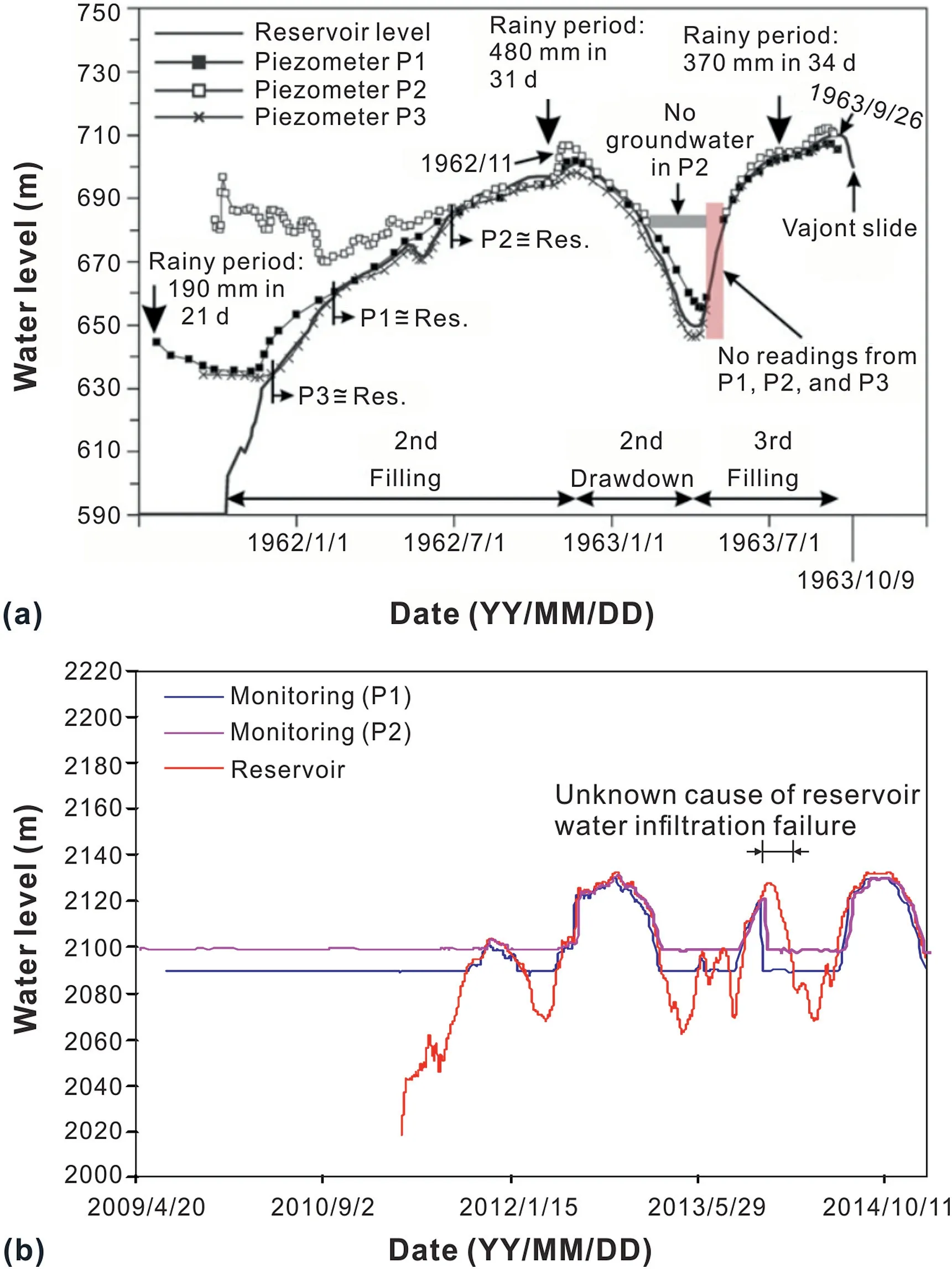
Fig.16.Monitoring results of the groundwater level of rock landslides: (a) The 1963 Vajont landslide (Paronuzzi et al.,2013),and (b) The rock landslide in the MEGR.
Declaration of competing interest
The authors declare that they have no known competing financial interests or personal relationships that could have appeared to influence the work reported in this paper.
Acknowledgments
We gratefully acknowledge the support of the National Key R&D Program of China (Grant No.2017YFC1501102),the National Natural Science Foundation of China (Grant No.41977229) and the Sichuan Youth Science and Technology Innovation Research Team Project (Grant No.2020JDTD0006).
Appendix A.Supplementary data
Supplementary data to this article can be found online at https://doi.org/10.1016/j.jrmge.2022.04.004.
 Journal of Rock Mechanics and Geotechnical Engineering2023年2期
- Journal of Rock Mechanics and Geotechnical Engineering的其它文章
- On the critical particle size of soil with clogging potential in shield tunneling
- Experimental investigations on effects of gas pressure on mechanical behaviors and failure characteristic of coals
- Strength and deformation characteristics of irregular columnar jointed rock mass: A combined experimental and theoretical study
- Characteristics of electromagnetic vector field generated from rock fracturing
- A multi-purpose prototype test system for mechanical behavior of tunnel supporting structure: Development and application
- Geotechnical investigation of low-plasticity organic soil treated with nano-calcium carbonate
