Predicting sediment flux from continental shelfislands,southeastern China*
Gaocong LI, Xiaoming XIA , Jianjun JIA, Yaping WANG , Tinglu CAI, Shu GAO,**
1 Department of Marine Technology, Guangdong Ocean University, Zhanjiang 524088, China
2 Second Institute of Oceanography, Ministry of Natural Resources, Hangzhou 310012, China
3 State Key Laboratory for Estuarine and Coastal Research, East China Normal University, Shanghai 200241, China
Abstract Continental shelfislands are contributors of terrestrial sediment supply to shelf regions, and the sediment flux from these islands shall be quantified. We calculated the sediment flux of continental shelfislands in the southeastern China using two empirical equations under two preconditions. The first, the sediment load/yield of the islands has the same pattern as the adjacent small, mountainous rivers along the coastline; and the second, each of the islands was treated as a single catchment. The results show that the sediment supply from these islands reached an order of magnitude of 1 Mt/ a, which is comparable to the supply from the local smaller rivers. A sensitivity analysis indicates that this value represents the lower limit of estimate; if the accurate amount of sub-catchments of any island is considered, then this value will be enhanced slightly. This study demonstrates that the sediment supply from continental shelfislands to oceans is an important factor aff ecting the regional sedimentation and, therefore, should be paid with attention.
Keyword: continental shelfislands; sediment flux; local rivers; shelf mud deposits; East and South China Seas
1 INTRODUCTION
Continental shelfislands are widely distributed in global shallow marine environments. Compared with oceanic islands, generated by submarine volcanic activities, these islands are closely correlated with adjacent continents in geographical and geological settings (Whittaker, 1998; Stankowski and Johnson,2014). Sediment supply to continental shelves is commonly considered to be dominated by two dominant sources, i.e., riverine and shelf-derived sediments (Nittrouer and Wright, 1994; Gao et al.,2011; Jia et al., 2018). However, shallow marine islands, which can also contribute to the deposits,have been often ignored (Li et al., 2018).
In order to quantify the sediment flux from continental shelfislands, long-term hydrologic and sediment observation data is needed. However, it is not available for us to establish empirical equations for the sediment flux calculation of continental shelfislands. One indirect method is to integrate islandwide sediment flux into the continent river-derived sediment flux because they are linked closely in both geographical and geological settings, especially before influenced by intense human activities.Traditionally, two distinct methods are used to quantify riverine suspended sediment flux to oceans.One is estimating the flux based on the denudation rate of continents (e.g., Ahnert, 1970; McLennan,1993), and the other is analyzing the data from hydrometric stations near river mouths (e.g., Holeman,1968; Milliman and Syvitski, 1992).
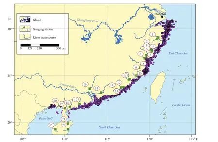
Fig.1 locations of the study rivers, hydrometric gauging stations, and continental shelfislands
For the first one, the prediction tends are usually overestimated because a large amount of eroded sediments is trapped within the catchment and never reaches the estuary (Milliman and Meade, 1983). For the second method, since not all rivers have hydrometric stations or without well-documented history, empirical formulae are commonly applied.Many empirical formulae, namely the global equations in this study, were developed to predict the sediment flux of continent rivers based on the relationships between fluvial sediment load and catchment parameters (e.g. area, maximum relief, and mean temperature) of hundreds of rivers around the world (Milliman and Syvitski, 1992; Mulder and Syvitski, 1996; Syvitski et al., 2003). In addition,modifications to prediction equations should be considered when using the global equations in specific areas, because significant differences in sediment yield exist between diff erent regions or diff erent sizes of drainage basins (Milliman and Meade, 1983;Milliman et al., 1999).
In this study, the sediment flux of continental shelfislands along the coasts of the East and South China Seas were quantified. First, the sediment load/yield pattern of the rivers catchments in the southeastern coastal regions including Hainan Island in China were considered suitable for this study, and each of the islands were treated as a single catchment. Secondly,two methods were used to calculate the sediment flux off these islands. At last, the eff ects of treating an island as a single catchment on its sediment flux to adjacent seas and their sedimentological implications were analyzed and discussed.
2 REGIONAL SETTING
The study area includes 23 coastal rivers and 8 227 continental shelfislands in southeast China (Fig.1).During the low sea-level periods of the Quaternary ice ages, these islands are connected to the mainland or Hainan Island (Whittaker et al., 2017). The outcrop rocks of these regions composed of almost consistent Cenozoic-Holocene igneous and sedimentary rocks(Gao, 1988). A monsoon climate exists in these areas:northerly winds predominate in winter (from November to March) and southeasterly in summer(from May to September). During summer months,these regions are influenced by typhoons. Cold outbreaks occur with winter storms hitting the coasts in winter (Shanghai Typhoon Research Institute of China Meteorological Administration, 2006; Gao et al., 2016). The annual precipitation is on average of 1 300-2 400 mm, occurring mostly between April and September. The mean yearly temperature for these islands ranges 16-24°C. The waves are moderate, and the tides are semi-diurnal on the East China Sea coast and diurnal on the northern South China Sea coast (Wang et al., 2001).
3 MATERIAL AND METHOD
3.1 Data collection and preprocessing
Three data sets are used in this study. The first is the parameters of the environmental background setting of the 23 catchments described above,including area, maximum relief, mean temperature,and mean rainfall. Twenty mountain/highland river systems were included in the mainland. Their mainstream length, maximum relief, and catchment area are within the range of 50-541 km, 596-2 158 m,and 425-60 992 km2, respectively. Three rivers in Hainan Island, i.e., the Nandujiang, Wangquanhe, and Changhuajiang rivers were also included. The second is the characteristic values of 26 hydrometric gauging stations of the rivers, including drainage area and sediment discharge. The third is the area coverage of the shelfislands. The maximum relief and catchment area of the continental shelfislands considered in this study are in the ranges of 0.1-1 404 m and ~0-490.9 km2, respectively. The total surface area of the islands is 4 418.49 km2(Xia, 2012).The sources of the first and second data sets are collected from published sources (Table 1), including mainly Zhang et al. (2015), Water Resources Department of People’s Republic of China (2017),and Baidu Wikipedia (http://baike.baidu.com). In order to avoid the inclusion of sediment flux that might be interfered by human activities, only the measurements at the hydrometric gauging stations between the 1950s and 1970s were considered as the sediment discharge. Sediment yield of the catchment was defined as the sediment discharge divided by the drainage area of a hydrometric gauging station. The area coverage data of the 8 227 islands were obtained from the data set in Xia (2012).
3.2 Calculation of the sediment flux
In terms of the geological and hydrological settings,assumptions were made to predict the sediment fluxes from the continental shelfislands: (i) the sediment load/yield derived from continental shelfislands is calculated by the same method as that used for adjacent small coastal catchment rivers; and (ii) each of the islands is taken as a single catchment. As such,two quantitative methods were adopted to obtain the sediment flux.
The first method for predicting the sediment flux of the islands is based on the mean sediment yield of the catchments. As such, the sediment flux of a continental shelfisland ( Qs) can be quantified by:

where Qyis the sediment yield (t/( km2· a)), A is the area of a continental shelfisland (km2), and the overbar denotes the average of all the rivers in consideration.
The second method takes the dominant factors of sediment flux into account. Three global empirical equations are modified by using characteristic values of the variables oflocal rivers. The first equation is from the Milliman and Syvitski (1992) model which predicts sediment flux by catchment area:
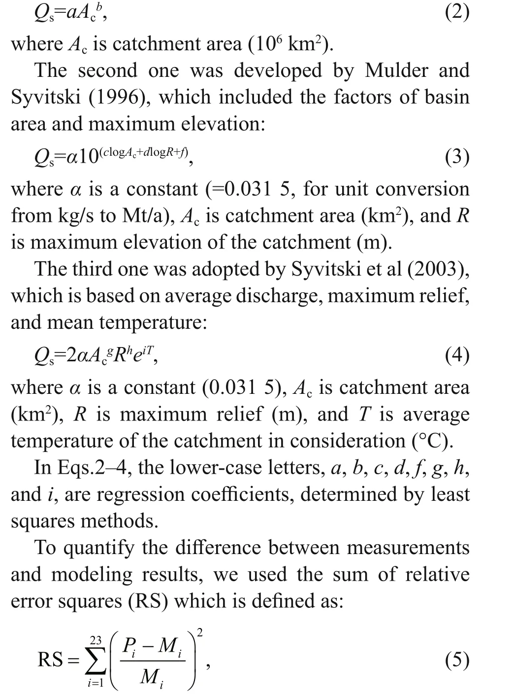
where Piand Miare the predicted and measured values of sediment flux, respectively, and obtained from the results of Eqs.2, or 3, or 4 and the hydrometric gauging station measurements, respectively. A smallRS value is indicative of a good fitting. Subsequently,the sediment fluxes for the continental shelfislands are calculated using the best-fit equations.
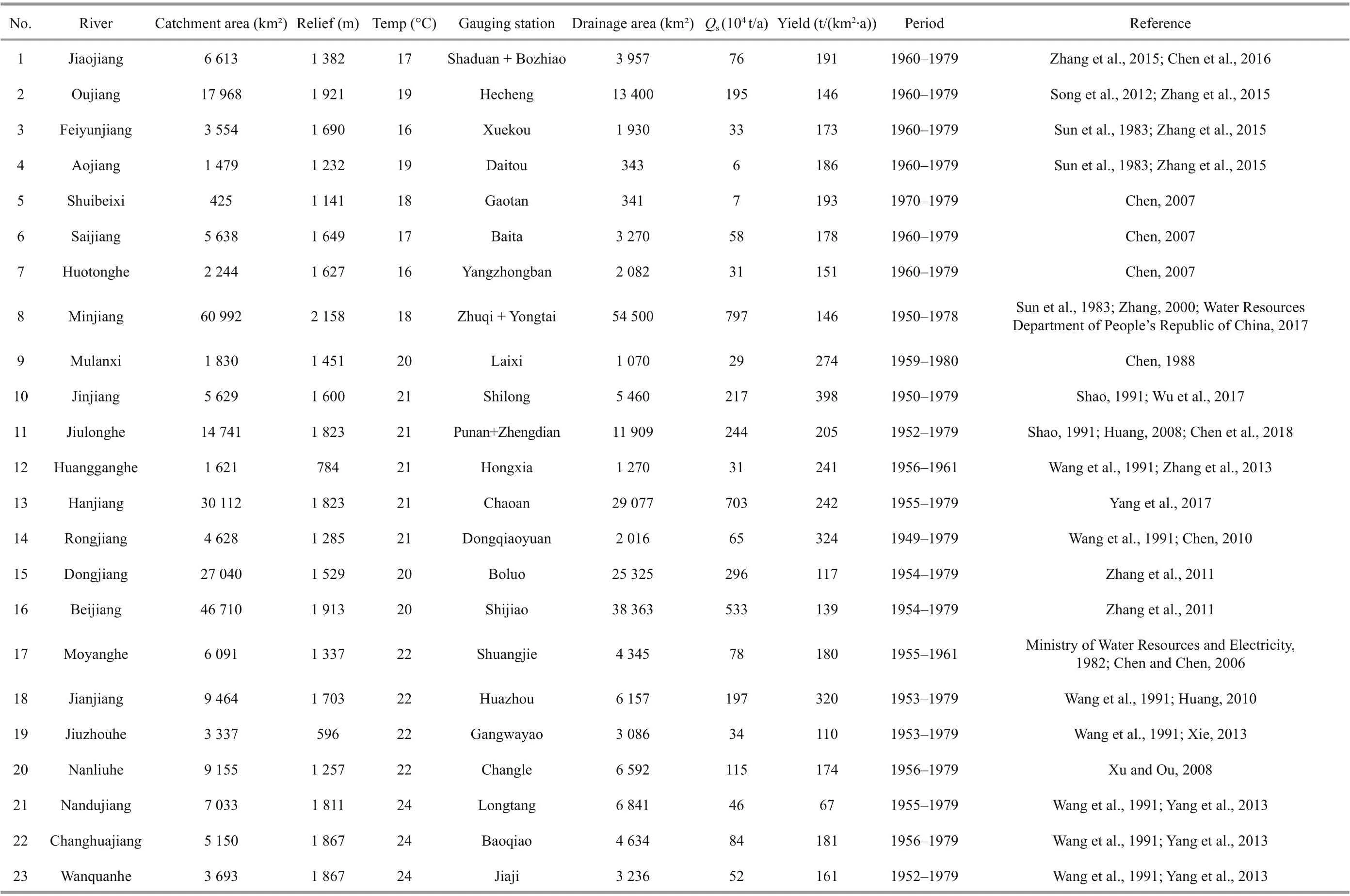
Table 1 Statistic of the 23 coastal rivers in southeast China

Fig.2 Relationships between drainage areas and relative error squares between predictions and measurements of themainland and Hainan Island catchments
4 RESULT
4.1 The best-fitted equation
Figure 2 shows the three regression equations based on Eqs.2-4, and their RS values. The results indicate that the relative error squares of the three equations for the catchments are small, i.e., generally below 0.25, although some of them were deviated by a factor of 2.5 to 3.25. When factor Acis considered alone, the RS (4.408 8) value is the smallest. For the equation including Ac, R, and T, the RS (5.941 8)value is the largest. And for the equation based on Acand R, the RS (4.425 2) value is in between. Thus, we use the best-fitted equation for the prediction ofisland sediment flux:

where A (106km2) is the area of a continental shelfisland.
4.2 Island sediment fluxes
The sediment fluxes from the islands in study area show a significant spatial trend, which are closely related to the size of the islands (Fig.3). The reason is that Qshas a linear or power function relationship with A according to Eqs.1 and 6. For both equations,the magnitude of Qsis similar, ranging between 100and 104t/a. In terms of total Qsof the islands, the results of two prediction methods are also close: Eq.1 predicts a value of 0.86 Mt/a, whilst Eq.6 predicts a slightly higher value of 1.14 Mt/a. Generally, the total flux has an order of magnitude of 100Mt/a.
5 DISCUSSION
5.1 The eff ects of treating an island as a catchment on Q s
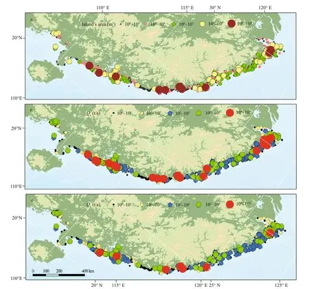
Fig.3 Spatial distribution patterns of the area (a), and Q s predicted by Eq.1 (b) and Eq.5 (c) for the shelfislands
One of the key issues to accurately interpret the sedimentary records of continental shelves is the sediment sources and their magnitude. The knowledge of sediment flux from islands is an important supplement for the continental shelf sedimentary record studies. In this study, based on the similarities between land catchments and shelfislands in terms of sediment load/yield, the total sediment flux is estimated. Whether or not this value is valid depends on the validity of the two assumptions made in the calculations. For the first assumption, because hydrometric gauging stations for continental shelfislands are rare, it is diffi cult to directly verify the consistency of sediment load/yield pattern between land rivers and continental shelfislands.
An indirect method is to use the model predictions for the adjacent mainland-based coastal catchments.Here, the global equations are adopted, using the characteristic values of variables of the river basins of the mainland and Hainan Island with regional signatures. The best fit function and sediment yield equation are selected to predict Qsfor the shelfislands.The outcomes of the two methods are similar, which indicate the feasibility of the first assumption.
For the second assumption, a continental shelfisland is treated as a single catchment. However, a continental shelfisland can contain several catchments in reality. Because of the lack of detailed area data of the “sub-catchments” for the islands, it is not practicable to calculate the sediment flux by a treatment of the sub-catchments. Instead, each of the islands is treated as a single catchment in this study.
The eff ects of such an assumption need evaluations.Let Anbe the area of the nthcatchment of an island, sothat we have:
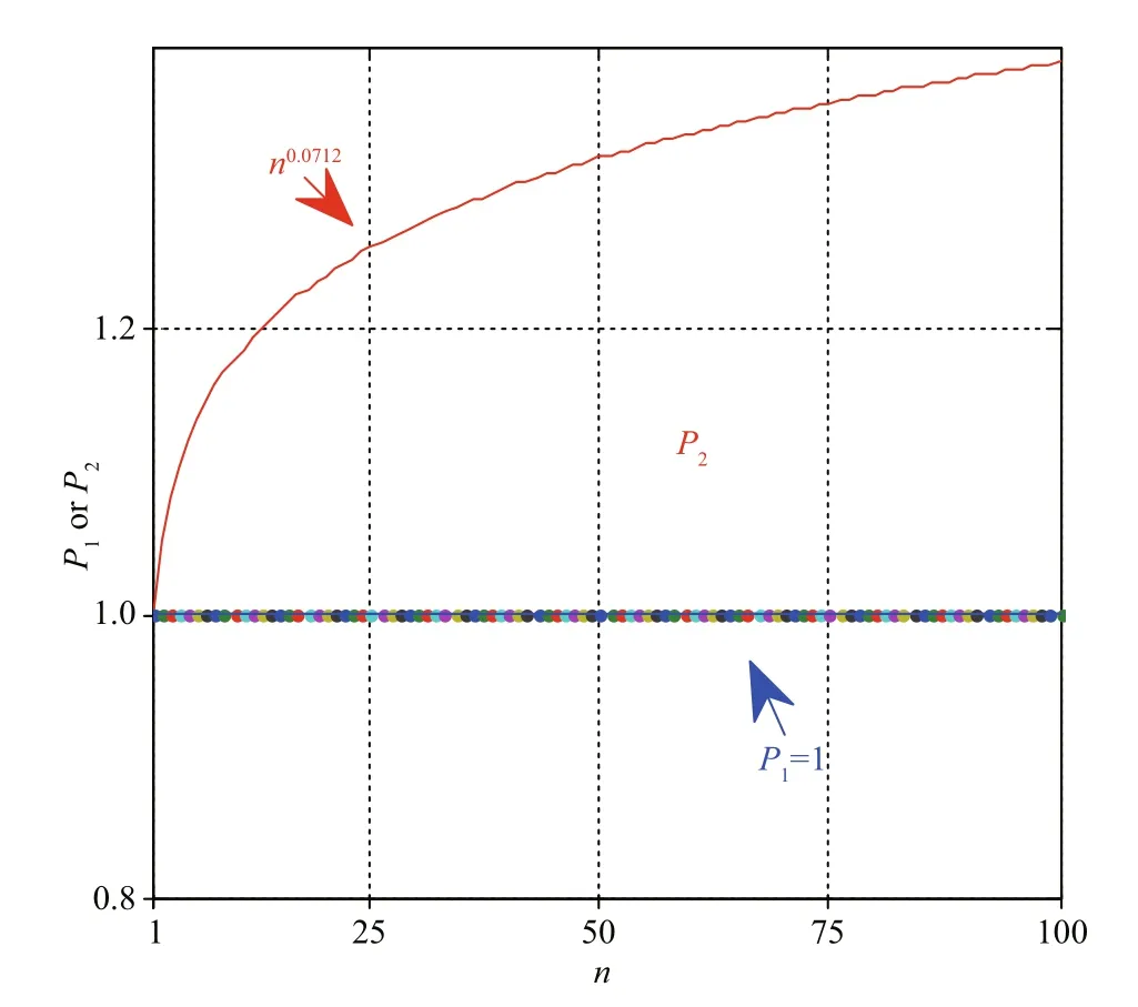
Fig.4 Relationships between the number of sub-catchments of an island ( n) and P 1 or P 2 regardless the catchment area distribution

Then, we introduce the index of P1and P2for assessing the difference which are defined as:
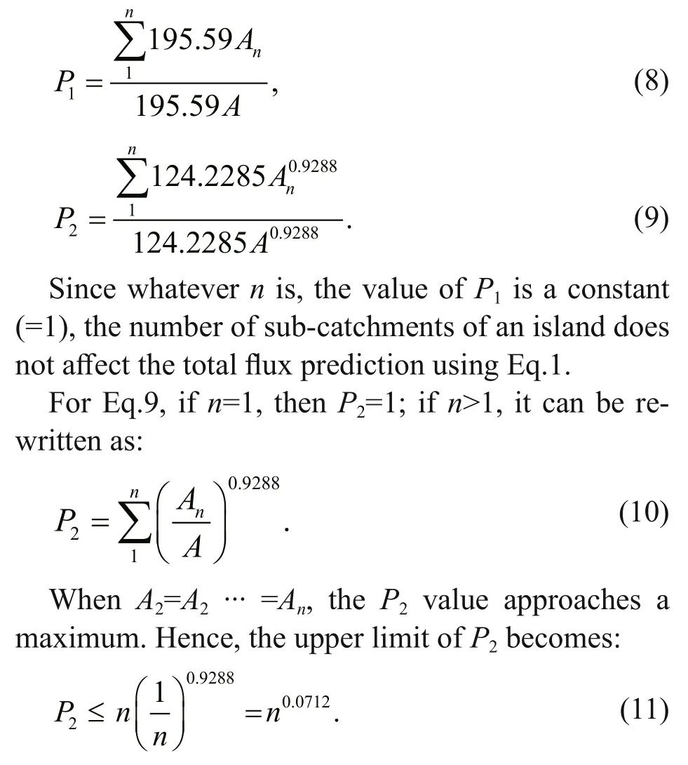
Therefore, when treating an island as a single catchment and using Eq.6, the prediction generates the lower limit of the sediment flux. The modified value will be larger than it by a factor of ( n0.0717-1)(Fig.4). Thus, the degree of underestimation is related to the number of the sub-catchments of an island.
Assuming that the number of the sub-catchments of each of the continental shelfislands is below 100,P2will range between 1 and 1.38. The total sediment flux from the islands ranges between 1.13 and 1.56 Mt/a. This magnitude is comparable to that of the small local rivers, such as the Jiaojiang (0.76 Mt/a),Moyang (0.78 Mt/a), and Nanliu (1.15 Mt/a) rivers(Table 1). Therefore, the sediment supply from continental shelfisland is significant and should not be neglected.
5.2 The geologic implications of the shelfisland sediment supply
Many studies had provided sedimentary insights into the Zhoushan Archipelago sediment supply for the adjacent areas, including a focus on the grain size(Yan et al., 1981; Li et al., 2002; Hu et al., 2009),clastic minerals (Sha, 2007), geochemical province(Liu et al., 2012), and sedimentary rate (Xu et al.,2012; Gao, 2013; Zhang et al., 2014; Gao et al., 2015).Based on their outcomes, the general pattern is that coarse sediments derived from the Zhoushan Archipelago are mainly deposited near the island shorelines, and the fine-grained materials may deposit further away from the shoreline (Li et al., 2018). We could deduce that the sediment supply of the continental shelfislands and the local small rivers should have certain influence on the growth of the distal muds associated with large rivers.
In terms of the magnitude of sediment supply to the Changjiang River distal mud deposits, the total contribution of continental shelfislands is important compared with the small local rivers (Table 1). The sedimentary materials supplied by the Changjiang River is the largest (108t/a), followed by the rivers discharging into the Zhejiang and Fujian coasts (104-106t/a) and the total contribution of the adjacent continental shelfislands (105t/a). Nevertheless, in response to the disturbance of human activities in the Changjiang River catchment, its sediment supply has been reduced significantly, enhancing the relative importance of the island derived sediment supply in the future.
During the Holocene, the sediment input from islands is a potent source to the shelf sedimentary systems. In present era, distal mud deposits occur in both Changjiang and Zhujiang (Pearl) rivers, but the large-scale sediment escape from their estuary did not start at the early stage of distal muds evolution (Gao et al., 2015; Li et al., 2018). According to the sedimentary characteristics of distal muds of Changjiang and Zhujiang rivers (Xu et al., 2012; Liu et al., 2014; Gao et al., 2015), large-scale sediment escape from the Changjiang Estuary did not occur until 2 ka ago, whereas that of the Zhujiang River started only around 100 a ago. Before these times,most of the sediment from the two rivers were trapped within the bay-head areas and estuarine waters (Gao et al., 2015).
Thus, their contribution to the distal muds should be very limited. The sediment supply from the local small rivers and the continental shelfislands could be two important sources of the formulation of the mud deposit areas back then. Afterward, the sediment from the major rivers dominates the sedimentary system that forms the deltaic distal muds. Although the sediment flux of each island is relatively small, the large number ofislands combine together that have the possibility to generate a detectable contribution to the distal muds. In particular, they provide both coarse- and fine-grained sediments throughout the life cycle of distal muds because of the short transport distance from the islands towards the distal muds.
Since the 1980s, there have been increasing attentions to continental shelf distal mud deposits that are closely related to large river deltas (Nittrouer et al., 1986; Kuehl et al., 1997; Correggiari et al., 2001;Warne et al., 2002; Cattaneo et al., 2003; Neill and Allison, 2005; Liu et al., 2001, 2009, 2014). Distal mud deposits are characterized by the inputs of suspended sediments mainly from continental rivers that accumulate within well-defined areas (Gao and Collins, 2014; Gao et al., 2015). However, the contribution of continental islands to the sediment flux of distal mud deposits is usually ignored. In fact,continental shelfislands not only provide continuously additional sediments, but also influence the shelf currents. Therefore, the following studies should be carried out in future: (1) identification of the islandderived sediment within the continental shelf mud deposits; and (2) assessment of the role of continental shelfislands in the formation of distal mud deposits.Additional in situ observations and sampling, together with numerical modeling eff orts, are needed to understand the continent-sea-island interactions.
6 CONCLUSION
(1) The best fit function for predicting the sediment flux of the continental shelfislands in study area is derived. By treating an island as a single catchment, a lower limit of the sediment flux is obtained, but the actual value is larger than that by a factor of ( n0.0717-1)(n is the number of the sub-catchments of a continental shelfisland).
(2) The sediment supply from the islands is estimated to be in the order of 1 Mt/a. This amount is comparable to that of the local rivers, which represents an important sediment source to continental shelf sedimentary system and should not be neglected.(3) For the present-day Changjiang River distal mud and the Zhujiang River distal mud areas, the two rivers delivered a limited quantity of sediment 2 ka and 100 a ago, respectively. At those times, the sediment discharged from small local rivers and continental shelfislands should serve as a major sediment source.
7 DATA AVAILABILITY STATEMENT
In this study, three data sets were used to estimate the sediment flux from continental islands, SE China. The first is the parameters of environmental background setting of the 23 coastal catchments,including area, maximum relief, mean temperature,and mean rainfall. The second is the characteristic values of 26 hydrometric gauging stations of the rivers, including drainage area and sediment discharge. The third is the area coverage of the shelfislands that pertains to the dataset in Xia (2012). The data sources of the first and two categories are collected from published literatures (Table 1),mainly Zhang et al. (2015), Water Resources Department of People’s Republic of China (2017),and the Baidu Wikipedia (http://baike.baidu.com).The first two datasets are open to public readers, but the last dataset is not available and is privileged information belonging to the Ministry of Natural Resources of China.
8 AUTHOR CONTRIBUTION
Xiaoming XIA, Jianjun JIA, and Tilu CAI produced the island’s dataset; Shu GAO, Jianjun JIA, and Gaocong LI conceived and posed the research question, and carried out the analysis, and Gaocong LI wrote the paper; Gaocong LI, Yaping WANG, and Shu GAO designed the study and interpreted the results. All authors commented on the manuscript..
9 ACKNOWLEDGMENT
Anonymous reviewers are thanked for their reviews of the original manuscript.
 Journal of Oceanology and Limnology2021年2期
- Journal of Oceanology and Limnology的其它文章
- Quantification of the impact of environmental factors on chlorophyll in the open ocean*
- Laboratory simulation of dissolved oxygen reduction and ammonia nitrogen generation in the decay stage of harmful algae bloom*
- Development of high-resolution chloroplast markers for intraspecific phylogeographic studies of Phaeocystis globosa*
- Effects ofiron and humic acid on competition between Microcystis aeruginosa and Scenedesmus obliquus revealed by HPLC analysis of pigments*
- Effect of river plume on phytoplankton community structure in Zhujiang River estuary*
- Exploring the sublethal genotoxic effects of class II organophosphorus insecticide quinalphos on freshwater fish Cyprinus carpio
