The Volume Calculation Method of Rock Collapses and Loess Landslides Triggered by the 1556 AD Huaxian M8 Earthquake in Shaanxi Province,China
ZHANG Yanbo,XU Yueren,DU Peng,LI Wenqiao,CHEN Lize and TIAN Qinjian
Key Laboratory of Earthquake Prediction,Institute of Earthquake Forecasting,China Earthquake Administration,Beijing 100036,China
Accurate volume calculation of each individual landslide triggered by strong historical earthquakes can help understand the characteristics of the typical earthquake-induced landslides,thus providing significant information for the modification of the focal parameters of historical earthquakes.In this study,we select one rock fall and three loess landslides triggered by the 1556 AD Huaxian M8 earthquake,compute their volumes using the low-altitude high-precision Unmanned Aerial Vehicle (UAV)photogrammetry and landslide profile restoration methods.The results show that:①the whole influencing area of the Huangjiagou Rock Fall is approximately 3.03 ×10⁵ m2 and the area of the collapsed rock accumulated at the slope foot is 3.33 × 10⁴ m2,accounting for approximately 10%of the entire influencing range.However,the estimated volume of the collapsed rock is only 0.699 × 10⁶ m3,indicating a rock fall with large influencing range but limited collapsed rock; ②the geological form of thethree loess landslides are preserved intactly,with volumes of 0.283 × 10⁸ m3,0.074× 108 m3,and 0.377 × 10⁸ m3.These important geological hazard relics reflect the strong vibrations and severe casualties in the meizoseismal area; ③loess landslides are the key reason of the serious death toll in the hilly-gully loess area.Our new method can be used to estimate the influencing area and the actual volume of each individual landslide,and rationally evaluate the role of earthquake landslides in the disaster.In addition,quantitative research on secondary disasters triggered by strong historical earthquakes is beneficial for understanding the surface process and focal parameters of the earthquakes.
Key words:1556 AD Huaxian earthquake; Rock fall; Loess landslide; Volume calculation
INTRODUCTION
The peripheral area of the Ordos block,which is characterized by numerous active fault systems,is one of the most intensive earthquake-prone zone in Chinese mainland (Shan Xiuzheng et al.,2002).It is also one of the areas where earthquake-induced disasters occur frequently,resulting in serious casualties.In particular,the geological structure of the southeastern boundary of the Ordos block is more complex,with several active faults intersecting with each other.On January 23rd,1556 AD,anM8earthquake occurred in Weihe Basin on the southeastern margin of the Ordos block (Xie Yushou,1992;Feng Xijie et al.,2003) (see Fig.1).In early years,scholars called it the “Guanzhong Great Earthquake” (Guo Zengjian,1957),which is currently known as the “ Huaxian earthquake” (Department of Geography,Shaanxi Normal University et al.,1990; Yuan Tinghong et al.,2010).The historical records edited by Yuan Tinghong et al.(2010)says“The mountains and rivers are shifted,the local mounds are rotated and moved,and the roads are changed by the strong shaking”; “The ground fractured,forming huge cracks where magma erupted”; “The mountain collapsed and the river overflowed; Most of the mountains collapsed.Among them,the Huashan Mountain looks is lowered than before”;and “About 830 000 people are killed,including officials,soldiers,and citizens” (Yuan Tinghong et al.,2010).According to the records,the earthquake has generated severe rock falls,loess landslides,dammed lakes,ground fissures,and the sand liquefaction phenomena,finally causing 830 000 deaths.The dual effects of strong vibration and coseismic landslides are important factors that have caused serious casualties in several regions(Xu Yueren et al.,2018).After the Huaxian earthquake,several prominently intensive aftershocks occurred,with a maximum magnitude of approximately 7 (Guo Zengjian,1957; Yuan Tinghong et al.,2010).Historical records also indicate that several aftershocks with magnitudes ranging 6-7 occurred within a few hours after the main shock,aftershocks of magnitude 5 occurred repeatedly within a few days,and aftershocks ofM≥3 were observed within 3-4 years (Yuan Tinghong et al.,2010).
The great Huaxian earthquake is the first earthquake with a magnitude of approximately 8 confirmed by historical earthquake records in China (Yuan Tinghong et al.,2010).Previous studies have determined that its seismogenic mechanisms include the Huashan Piedmont fault (HSPE) and Weinan Plateau front fault (WPF) (Li Xianggen et al.,1983;Hou Jianjun,1985;State Seismological Bureau,1988;Xu Xiwei et al.,1988;Wan Jinglin et al.,2000; Yin Gongming et al.,2001; Yuan Tinghong et al.,2010; Yang Yuanyuan et al.,2012; Rao Gang et al.,2014,2015; Lin Aiming et al.,2015; Ma Ji et al.,2016; Du Jianjun et al.,2017;Xu Wei et al.,2017;Xu Yueren et al.,2018).Several ground fissures,sand liquefaction occurrences,landslides,and rock falls caused by earthquakes have been found along the faults (Zhang Anliang et al.,1989; Department of Geography,Shaanxi Normal University et al.,1990; Li Zhaoshu et al.,2007; Yuan Tinghong et al.,2010).These co-seismic loess landslides are concentrated in the Weinan and Lingbao areas,respectively,which are the two ends of the seismogenic fault.Rock falls and bedrock cracks are mainly distributed in the middle-height and high mountains in the northern slope of Huashan Mountain.Dozens of rock falls have occurred from Mayu mountain in the west to Huangfuyu mountain in the east,and the overall distribution direction is nearly east-west(Li Zhaoshu et al.,2007; Yuan Tinghong et al.,2010; Xu Yueren et al.,2018).The accumulation of collapsed rock and landslides usually overwhelm farmlands,destroy houses,block rivers in the local areas,further destroying economic construction and endangering people’s lives.To understand the damage caused by strong historical earthquakes,the first is to understand the spatial scale of the co-seismic secondary disasters(Chen Zhengchao et al.,2014).Post-landslide high-resolution images and Digital Elevation Map (DEM) data can be obtained through field investigation and remote sensing analysis;however,it is difficult to obtain DEM data before a landslide(Han Jiannan,2018;Tian Ji,2018).Such problem seems more significant for landslides induced by strong earthquakes.Accurate volumes of the collapsed rock and landslides cannot be computed without the preearthquake data.
In recent years,the development and improvement of low-altitude UAV photogrammetry technology has made the acquisition of 3-D spatial landform data convenient,effective,accurate,and low-cost.As a result,the technique has been widely used in the investigation of rock collapses and landslides (Yamagishi H.et al.,2004;Schwab M.et al.,2008; Peng Dalei et al.,2017; Tian Ji,2018).Combining previous studies and field investigations,this study selected the Huangjiagou Rock Fall in the Dafuyu Valley on the northern slope of the Huashan Mountain (Yuan Tinghong et al.,2010),and three co-seismic loess landslides near Weinan (Xu Yueren et al.,2018) to calculate the volume of each accumulation mass generated by the 1556 AD Huaxian earthquake (Fig.2).Yuan Tinghong et al.(2010) identified the Huangjiagou rock fall as a co-seismic rock fall associated with the 1556 Huaxian earthquake (Yuan Tinghong et al.,2010).Xu Yueren et al.(2018) interpreted a large number of co-seismic loess landslides triggered by the 1556 AD Huaxian earthquake (Xu Yueren et al.,2018).In addition,during the field investigation of this study,local residents said that the large amount of rubble in Huangjiagou was triggered by this earthquake event.The same situation is observed in the loess tableland region,in which the local residents witness landslides in abundant slopes and valleys.As a result,several dammed lakes are formed,which buried people living on the tableland and slopes.In this study,we select typical co-seismic landslides and bedrock collapses triggered by the 1556 AD Huaxian earthquake,and utilize low-altitude UAV photogrammetry to obtain high-precision DEM and orthophoto images.Also,we take the adjacent undeformed landform elevation as the elevation before the collapses and landslides,for the purpose of obtaining the landform elevation difference of the accumulation body.Meanwhile,the volume is obtained by multiplying the projection area of the accumulation body and the elevation difference.Furthermore,we conduct a detailed analysis of the zoning,disaster-causing methods,and accumulation characteristics of the collapsed landslides to verify whether the recorded scale of co-seismic secondary disasters is ture (The collapsed surface is hundreds of meters high,and the collapsed body is nearly one km long,and rolling rocks are distributed everywhere (Yuan Tinghong et al.,2010)).The information provide by this research has important reference significance for restoring and understanding the spatial distribution range of the co-seismic and secondary disasters of the strong historical earthquakes in Huaxian County.Furthermore,it provides a new method for calculating the volume of collapses and landslides.
1 DATA AND METHODS
The data used in this study are raw visible light data and point cloud data collected by UAV low-altitude photography,and processed by software to obtain a Digital Orthophoto Map (DOM) (Fig.2) and Digital Elevation Map (DEM) (Fig.3).Fig.2 shows the impact range and morphological characteristics of the collapses and landslides.The UAV photogrammetry system is a low-altitude photography system with GPS navigation,remote control and monitoring,and automatic attitude and speed measurement (Peng Dalei et al.,2017).The data acquisition system used in this study is based on the DJI UAV Phantom4Pro flight platform,which is equipped with a high-resolution digital remote sensing equipment as the airborne sensor and consists of UAV photography hardware and software systems.The entire data acquisition,processing,and calculation process is shown in Fig.4.
Research methods include historical document collection,field surveys,data acquisition,and indoor analysis.Historical records indicate that the Huaxian earthquake has triggered serious secondary disasters,such as bedrock collapses and loess landslides,leading to severe casualties (Yuan Tinghong et al.,2010; Xu Yueren et al.,2018).

Figure 1 Distribution of landslides and collapses triggered by the 1556 AD Huaxian earthquake (Modified after Yuan Tinghong et al.,2010; Xu Yueren et al.,2018)

Figure 2 Orthophotos of rock falls and loess landslides in this study

Figure 3 DEM map of rock falls and loess landslides showing the location of cross sections

Figure 4 Flow chart of data acquisition,processing,and volume calculation
Based on previous studies,a field survey route is designed.Focusing on recorded typical co-seismic bedrock collapses and loess landslides,we investigate the area where bedrock collapses and loess landslides may exist.The results show that rock falls mainly occur on mountain slopes,while loess landslides mainly develop on riverbank valley slopes and hilly loess valleys (Xu Yueren et al.,2018).After the comprehensive analysis,we select one typical rock fall and three loess landslides for the study.Considering the impact of weather,light,terrain,and other factors on data collection,a UAV aerial survey operation is performed to obtain data based on time and location.The collected data provide us the length,width,and height differences between the front and rear edges,the sliding distance and projection area of the accumulation body.These parameters are used to calculate the accumulation volume.
2 VOLUME CALCULATION
Based on the analysis of the co-seismic rock falls and loess landslides generated by the typical Huaxian earthquake,whether it is a rock avalanche or a soil landslide,the material movement process of both of them represents material loss in the source area and material addition in the accumulation area; therefore,the goal is to calculate the volume of the accumulation area.Furthermore,the hazards of rock falls and loess landslides are directly related to their accumulated materials,such as blocking valleys,roads,and destroying houses.This study uses the method of calculating the product of the projected area and the average elevation difference to determine the accumulation volume.Due to the fact that accurate volume calculation is based on high data precision; thus,we obtain the DEM data with an accuracy of 0.6 m and DOM data with an accuracy of 0.2 m using UAV photogrammetry (Xiong Daokun et al.,1990).According to DOM interpretation and field investigation,the influencing scope of the study area is delineated and divided into several sub-regions:source area,circulation area,and accumulation area.The inactive area at the edge of the affected area is regarded as the landform before the landslide for the elevation reference.The Huangjiagou Rock Fall is located at the edge of the Ⅹ-intensity zone of the Huaxian earthquake (Fig.1) and composed of Huashan granite (Yuan Tinghong et al.,2010).After the collapse occurred,bedrock rolled down and piled up at the foot of the slope to Huangjiagou Block.The rock collapsed under the influence of gravity and seismic waves,with obvious zoning characteristics.The orthophoto of Fig.2 shows well-preserved vegetation at the top of the slope of the bedrock due to the effect of material deficiency,while the accumulation of the collapsed rock at the foot of the slope inhibits natural vegetation growth,and the gray-white rock blocks are clearly exposed.From the top of the slope to the foot of the slope,the overall trend shows that the covering level of vegetation decreases,and the rock outcrops increase.Loess landslides are different from bedrock collapses.The sliding materials are viscous,and the slope of the terrain is low,resulting in inconspicuous divisions and the sliding materials move approximately as a unit.The region where a loess landslide occurs is often divided into the sliding source area and the accumulation area based on volume change (Peng Dalei et al.,2017).In addition,the region has no obvious transport area,and instead,the source and accumulation areas overlap spatially.The position of the front edge of the slope is replaced by the back or middle of the accumulation body.Meanwhile,the overall volume of the sliding source area decreases along the material movement direction,and the volume of the accumulation area increases.At the rear end of the landslide,the sliding surface is nearly straightly upright and exposed as the back wall of the landslide.The characteristics of the sliding body are basically unchanged; however,the angle of the slope changes.The angle of the upper sliding-body slope decreases,while the angle of the lower soil body increases owing to the downward pressure (Chen Yongming et al.,2006).The surface of the sliding body has been artificially reclaimed as a field with sparse vegetation.By comparison,the back wall of the landslide which has not been reconstructed has dense vegetation,forming an obvious boundary.
Taking advantage of the DEM data to interpret the range of the accumulation area,the projected accumulation area can be directly calculated through GIS software.Then,the comparative profile before and after the bedrock collapses and loess landslides are made in Fig.6 and Fig.7.According to the morphological trend of the back wall,the sliding surface information is inferred,and the elevation difference before and after the landslides is obtained.Meanwhile,the determination of the position numberthe cross section also needs to meet the following requirements:The selected cross sections should be parallel to the material movement direction and be sufficiently representative of the morphological characteristics of the research objects.Also,they should cover the influencing scope of the study (Fig.3).
The method for determining the average elevation difference and the relationship between the projected accumulation area and the actual area is described as follows:
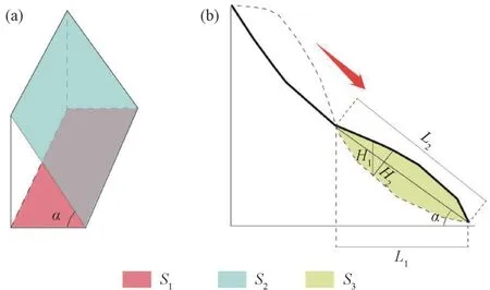
Figure 5 Calculation principle of the collapsed landslide accumulation body
In theory,the accumulation body volume is calculated by multiplying its floor area and the average thickness.However,the accumulation area obtained from the DEM data is actually the area projected on the plane; therefore,when calculating the volume,it is necessary to calculate the average elevation difference between the top and bottom of the accumulation body instead of calculating its average thickness.Fig.5(a) schematically shows the relationship between the area of the accumulation body and its projected area,according to the formula below:

whereS1is the projected accumulation area,S2is the actual accumulation area,andαis the slope angle of the accumulation body.
Fig.5(b) shows the average elevation difference.The oblique straight line in this figure represents the connection line between the highest point and the lowest point of the elevation of the accumulation body.The thick line represents the surface morphology curve after the collapse or landslide activities,the curved dashed line indicates the bottom boundary of the accumulation body,and the area enclosed by the two lines indicates the cross section of the accumulation body.The relationship obtained from the figure is obtained as follows:

whereL1represents the projection length of the accumulation,L2represents the length of the accumulation,αrepresents the slope angle of the accumulation body,H1stand for the average elevation difference,H2represents the average thickness,andS3represents the cross-sectional area of the accumulation body.
In summary,the data ofS1,S3,andL1can be directly obtained through processing DEM data using ArcGIS software,and Equa.(1),(2),and (3) can be used to calculate the volume of the accumulation body:

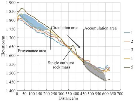
Figure 6 Flve cross sections of the Huangjiagou Rock Fall(the cross section locations are shown in Fig.3)
3 RESULTS AND DISCUSSION
These five topographical cross sections in Fig.3 of the Huangjiagou rock collapse are determined according to the above requirements,including one cross section prior to the collapse for comparison.Seven topographical cross sections of the Anmiao Village Landslide are determined,including one pre-collapse section.Similarly,five sections for both the Wanghuwan and Shangmaro landslides are determined,and each of them includes one precollapse cross section.The elevation difference is obtained by comparing the cross sections before and after the rock fall and loess landslide activities.The rock falls cross section(Fig.6) and the loess landslide cross sections (Fig.7) show the basic data of the collapse and three loess landslides (Table 1).Using Equa.(1),(2),(3),and (4),we calculate the volume of the rock fall in Huangjiagou and three loess landslides in Xiaojin Township.The results are shown in Table 1 and Table 2.
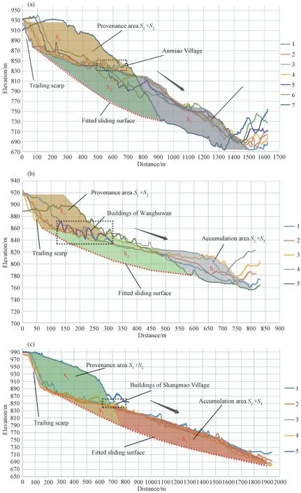
Figure 7 Cross section of three loess landslides(The cross section locations are shown in Fig.3)

Table 1 Basic data of the collapse and landslides

Table 2 Results of the Huangjiagou Rock Fall
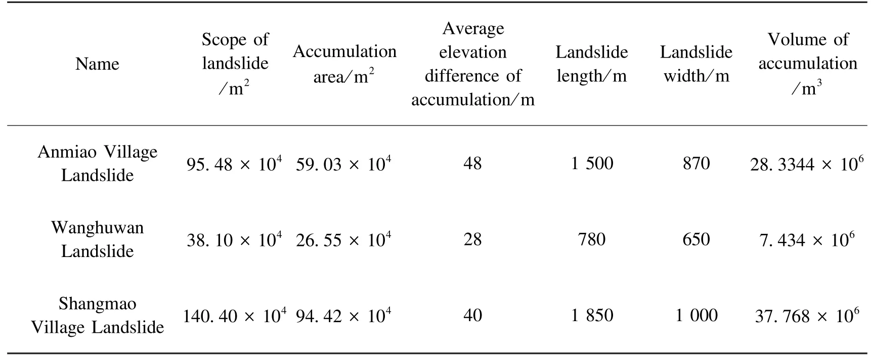
Table 3 Results of three Xiaojin Township loess landslides
Strong historical earthquakes often result in severe damage which leaves various imprints on the ground surface.Despite of long-time natural and man-made modifications,the imprints are still prominent and are different from those marks caused by contemporary earthquakes or weather and geography factors.Most of the collapses and landslides in contemporary times are characterized by small volume,obvious artificial modification,and weak natural recovery ability.On the contrary,the collapses and landslides triggered by strong historical earthquakes are large in scale and have a certain degree of natural recovery ability.However,due to the severely-damaged ground surface resulted from vast scale earthquake-induced landslides,the imprints on the surface are still clearly visible,including the bedrock deficiency in the source area,numerous huge rock fragments at the slope foot and on the slope surface,the clear and smooth rear end,the straight back wall,and the erosion pattern of the valley changed by the accumulation body.In addition,the man-made modification during the long time span is also obvious.For example,the signs show that people use the exposed base rock surface for quarrying,build houses in the upper part of loess landslide accumulation bodies where the angles are reduced.Furthermore,the arcshape rear end of the landslides has changed the shape of roads,and people take advantage of the landslide-induced dammed lakes to build dams and reservoirs.(Fig.8).

Figure 8 UAV image in the study area
Influenced by various factors,it is difficult to obtain the volume of landslides induced by strong historical earthquakes with high precision.There are numerous methods to calculate landslide collapse volume,among which the traditional method is to calculate the landslide volume through the statistically empirical formula between landslide area and volume.Particularly,the volume of earthquake-induced landslides is calculated based on the statistical relationship between earthquake magnitude and landslide volume (Malamud B.D.et al.,2004).For the volume calculation of the rock fall and loess landslides triggered by the 1556 AD Huaxian earthquake after more than 400 years of natural and man-made modification,the results obtained by traditional method may be inaccurate.However,with the development of remote sensing technology and low-altitude UAV photogrammetry,the use of high-resolution remote sensing images and DEM data to calculate the landslide volume is more accurate than traditional methods (Xu Chong.et al.,2018).As shown in Table 4,this study compares the results with those obtained by the seismic landslide volume-area empirical formula given by the global seismic landslide database (Guzzetti F.et al.,2009; Larsen I.J.et al.,2010).The results show that the latter result is much larger than the former one calculated by this study.The results obtained using the most obvious
empirical formula are 7.3296 × 10⁶m3and 6.5726 × 10⁶m3,which are more than 10 times larger than the calculation result 0.6993 × 10⁶m3in this study.Considering the uncertainty of landslide causes and the corresponding environmental factors,Guzzetti F.et al.(2009)analyzed more than 600 landslides worldwide,and finally projected the landslide volume and area data on a coordinate system (Guzzetti F.et al.,2009).However,the constructed empirical volume-area formulaV=αAγis independent of these uncertain factors,leading to a large error in this empirical formula.The calculation results will change with the determined sizeγthat ifγis increased by 0.1,the calculated volume will be doubled(Larsen I.J.et al.,2010).Based on the influence of erosion and weathering,Larsen I.J.et al.(2010) analyzed more than 4 000 landslides,including bedrock and soil landslides.The scale indexγin the established scaling power-law equationV=αAγwas limited to 1.1-1.3(soil landslides) and 1.3-1.6 (bedrock landslides).However,it is doubtful whether the basic data of the obtained empirical formula is sufficiently representative.To conclude,the aforementioned statistical empirical formulas for volume calculation are based on the total influence area of the collapse or landslide,leading to larger-than-normal results.Compared with loess landslides,rock collapses are usually more obvious.In detail,earthquake-induced rock collapses often lead to large-scale rolling bedrocks and each individual rock is large.Combined with the huge elevation difference,these rocks often generate high kinetic energy and a largely affected area.The rock fall zones are obvious; in the middle circulation area,there will also be bedrocks scraped by rolling stones or accumulation of small volumes of rolling stones.Similarly,this area will also increase the total area,and generally occur on mountain slopes with large slope angles.Basically,these collapsed materials are accumulated at the foot of the slope,while in the circulation area and the source area,the sporadically distributed accumulation bodies can be ignored.Therefore,the collapse accumulation area is mainly concentrated at the foot of the slope.As shown in Table 2,the accumulation area is only approximately one-tenth of the total area of rock falls,and the traditional empirical formula to calculate the volume of the Huangjiagou Rock fall does not match the actual volume scale.Thus,based solely on the interpreted area and empirical formula,both the source area and the circulation area are involved in the calculation,resulting in the calculated landslide volume being significantly higher than the actual collapse volume.In contrast,the earthquake-induced loess landslides are different.The volume of the three loess landslides in Xiaojin Township only shows slight difference.Under the condition of strong vibrations,the sliding body of the loess landslide moves down roughly as a whole unit due to the restricted direction associated with loess viscoplasticity.Meanwhile,the affected landslide area is not excessively influenced by the movement uncertainty of the sliding materials (Xu Qiang et al.,2016).However,compared with the calculation results of the landslide cross section restoration method in this study,the results obtained using the empirical formula still exaggerate the landslide volume.For the analysis and calculation of a single landslide,the traditional empirical formula method can only be used as a qualitative research method because the accuracy of the calculation result is insufficient.This study uses high-precision UAV photogrammetry technology to obtain data,providing more accurate results than those obtained by traditional methods.It also provides a new method for the study of secondary disasters generated by historical earthquakes.

Table 4 Comparison of volume calculation and traditional methods
According to the calculated volume,landslides can be divided into small,medium,large,and super-large landslides (Zhang Xiaoyong et al.,2013) (Table 5).Yuan Tinghong et al.(2010) classified the bedrock collapses and landslides generated by the Huaxian earthquake into four categories:small,medium,large,and massive.Among them,the Huangjiagou Rock Fall is classified as a massive collapse (Yuan Tinghong et al.,2010).The calculation results obtained in this study show that although the Huangjiagou Rock Fall has a large impact area,the volume of collapse accumulation does not reach the scale of a giant collapse; thus,we consider that it should be classified as a large collapse landslide.In addition,the calculated volume of the three loess landslides is also much larger than the super-large landslide classification limit which is 3 000 000 m3,indicating the huge scale of the co-seismic loess landslides.As recorded in historical documents,co-seismic secondary disasters such as large-scale bedrock collapses and super-large loess landslides are important factors for the death toll of the Huaxian earthquake in 1556 AD,exceeding 830 000.The loess landslide selected in this study is located on the edge of the loess plateau where people live in caves.When an earthquake occurs,plenty of caves in the rear edge area of the landslide will be pulled down as part of the landslide body.Meanwhile,village residents at the bottom of the slope will also be buried because of the influx of substantial sliding materials,causing serious casualties.Therefore,it is reasonable that these co-seismic loess landslides have caused serious casualties.However,several places which are not affected by landslides are also collapsed,indicating that some areas are destroyed by the earthquake itself,but not the induced landslides.Even in hilly areas where landslides frequently occur as primary hazards,the death tolls cannot be totally related to the landslides,and instead,earthquakes are the most direct reason.Due to geographical conditions,the villages in the mountainous area are different from those in side slopes where people live in caves.Instead,they gather in the flat bottom of the deep valley as village tribes.Because the source area of the collapsed body of the mountain is located near the steep ridge,the collapsed body often accumulates at the foot of the slope.When an earthquake occurs,the collapsed body will bury the residents below and lead to heavy casualties.Therefore,the disaster-causing process of bedrock collapse and loess is not the same.When a collapse or landslide occurs,the image data of the disaster site can be quickly obtained through UAV photogrammetry,and high-resolution DOM and DEM image maps can be obtained through software processing.The obtained data can assist in damage determination and post-disaster rescue after landslide disasters,compensate the limitation of poor visualization of traditional line drawing,and meet the requirement of fast,accurate,and efficient post-disaster rescue work.As shown in the flow chart in Fig.4,after the collapse and landslide occurred,data can be obtained directly from the disaster site for area calculation.The study overcomes several adverse factors including changing shooting plans and unfavourable weather caused by cloud layers in mid-or high-elevation.As a result,basic data can be obtained within a few hours,providing detailed first-hand information such as influencing area and accumulation body volume of the landslide.

Table 5 Classification of landslide scale
4 CONCLUSIONS
The volume of the collapse and landslide is calculated from remote sensing images and DEM data.In the process,we make full use of the advantages of low-altitude UAV photogrammetry which is characterized by high anti-interference capability,flexible operation,and high data precision.Then we calculate the volume of the large-scale bedrock collapse in Huangjiagou Dafuyu Huashan and three super-large loess landslides in Lintong Xiaojin Township of the Weinan Platform.The results show that:①the Huangjiagou rock fall has an estimated volume of 0.699 × 10⁶m3,collapsed projection length of 600 m,width of 700 m,accumulation area of 3.33 × 10⁴m2,and an average elevation difference of 21 m.Although the impact range of this collapse is large,the actual collapse volume does not reach the scale of“massive collapse” level.This is inconsistent with previous studies(i.e.historical documents and inscriptions) related to the secondary disasters of the Huaxian earthquake.②The volumes of the three super-large loess landslides in Xiaojin Township are 0.283 × 10⁸m3,0.074 × 108m3,and 0.377 × 10⁸m3,respectively.Studies regarding other similar-scale co-seismic landslides also confirm that the magnitude of the Huaxian earthquake and the development of co-seismic secondary disasters are extremely large.Furthermore,their results also show that co-seismic and secondary disasters are important factors that may cause heavy casualties in this major earthquake.In this study,the calculated scales and volumes provide an important scientific reference to aid the understanding of the spatial distribution of the co-seismic and secondary disasters of the Huaxian earthquake,identification of the characteristics of co-seismic secondary disasters,and seismic risk assessment in earthquake-prone zones.
 Earthquake Research Advances2020年4期
- Earthquake Research Advances的其它文章
- The Guest Editors of This special issue are:
- The Calculation Method for the Volume of Landslides and Dammed Lake Sediments Triggered by a Strong Historical Earthquake in the Loess Plateau:A Case Study of Qiuzigou,Gansu Province,Northwest China
- Impact of the Rainfall Intensity and Seepage on Slope Stability in Loess Plateau1
- Relationship between the Landslides Triggered by the Tongwei M7 Earthquake in 1718 AD and the Disappearance of Yongning Ancient Town
- Interpretation of the Spatial Distribution Characteristics of the Co-seismic Landslides Induced by the 1920 Haiyuan M8 Earthquake Using Remote Sensing Images1
- Early Identification of the Jiangdingya Landslide of Zhouqu Based on SBAS-InSAR Technology1
