Early Identification of the Jiangdingya Landslide of Zhouqu Based on SBAS-InSAR Technology1
YU Haihua ,CAI Guolin∗ ,GAN Quan and SHEN Dong
1) Faculty of Geosciences and Environmental Engineering,Southwest Jiaotong University,Chengdu 611756,China
2) Sichuan Bureau of Surveying,Mapping and Geoinformation,Chengdu 610000,China
SBAS-InSAR technology is characterized by the advantages of reducing the influence of terrain-simulation error,time-space decorrelation,atmospheric error,thereby improving the reliability of surface-deformation monitoring.This paper studies the early landslide identification method based on SBAS-InSAR technology.Selecting the Jiangdingya landslide area in Zhouqu County,Gansu Province as the research area,84 ascendingorbit Sentinel-1A SAR images from 2015 to 2019 are collected.In addition,using SBAS-InSAR technology,the rate and time-series results of surface deformation of the landslide area in Jiangdingya during this period are extracted,and potential landslides are identified.The results show that the early landslide identification method based on SBAS-InSAR technology is highly feasible and is a better tool for identifying potential landslides in large areas.
Key words:SBAS-InSAR; Jiangdingya landslide; Early identification; Deformation rate; Sentinel-1A
INTRODUCTION
Geological disasters occur frequently in the mountainous areas in western China,accounting for 60% of national geological disasters (Huang Runqiu,2009).Among them,landslides account for a large proportion.Due to the lack of large-scale monitoring and identification of landslides,early warning and accurate forecasting cannot be carried out,and the situation of “there is no landslide in the surveyed area,and there is no mapping in the landslide area” often appears (Liu Chuanzheng,2015).In particular,the ability of early identification,monitoring,and early warning systems is far from enough,resulting in serious potential security hazards to people’s lives and property,as well as the national infrastructures (Yin Yueping,2013).Therefore,effective landslide identification technology is urgently needed to identify potential landslide hazard areas in advance.
For such early identification,it is vitally important to obtain the surface deformation of potential landslides.At present,traditional field surveys,geomorphologic mapping,and other investigative methods cannot be implemented in mountain areas with complex terrains.Furthermore,they suffer from inferior timeliness and small monitoring ranges,which cannot meet the requirements of early identification (Zhang Shijia et al.,2018; Wang Zhihua,2007).The landslide identification method based on remote sensing has made up for the deficiency of traditional methods and has become one important means of early landslide identification,monitoring,and early warning.However,optical remote sensing is vulnerable to adverse weather,such as clouds and fog,and cannot be deployed at night.In contrast,interferometric synthetic aperture radar (InSAR),as an active remote sensing tool,has the capability of all-weather and all-day operation and higher monitoring accuracy,and it has been widely used in early landslide identification.
The application of InSAR technology in landslide information extraction mainly involves the use of differential interferometric synthetic aperture radar (DInSAR) and differential interferometry using time series.Due to the influence of terrain simulation,time-space decorrelation,and atmospheric error,the application scope of DInSAR technology is limited by plentiful factors.The method of differential interferometry using time series eliminates the influence of the these three factors.Meanwhile,it can monitor the cumulative micro-deformation of long time series and is thus widely used in volcanic research (Babu A.et al.,2019; Niu Yufen et al.,2019),seismic deformation field inversion (Şentürk S.et al.,2019),surface subsidence monitoring (Yin Hongjie et al.,2011),landslide identification,and early warning (Colesanti C.et al.,2003; Dong Jie et al.,2018).Among the various methods of differential interferometry using time series,the most representative ones include permanent scatter InSAR (PS-InSAR) (Ferretti A.et al.,2001) and small-baseline subset InSAR (SBAS-InSAR) (Yin Hongjie et al.,2011;Liu Peng et al.,2013).PS-InSAR technology can accurately reverse surface deformation using the displacement of PS points that remain stable for a long time and are less affected by time-space decorrelation.However,PS-InSAR technology requires 15-20 images or even more (Ge Daqing,2013),and it is difficult to extract permanent scatterers in areas with complex terrain,high vegetation coverage,and limited SAR images,making it difficult to monitor surface deformation (Zhang Yi,2018).Compared with PS-InSAR,SBAS-InSAR requires fewer images and does not need to extract PS points,solves the problem of decorrelation caused by excessively long time-space baseline,and improves the temporal resolution of monitoring,which is conducive to the analysis of surface deformation time series in non-urban areas (Yin Hongjie et al.,2011; Liu Peng et al.,2013).
In view of the numerous advantages of SBAS-InSAR technology,many scholars have conducted landslide identification research based on SBAS-InSAR technology.Zhang Shijia et al.(2018) obtained the surface deformation of the Minjiang River Basin and verified the applicability of SBAS technology in landslide identification.Zhang Yi (2018) extracted the deformation information of a landslide and unstable slope in Zhouqu County by combining different multi-period and multi-band SAR images,providing a reference for disaster prevention and mitigation work in Zhouqu County.
As the Sentinel-1A satellite has wide coverage and a short revisit period,its images have become an important data source for disaster monitoring,giving them considerable application potential in the field of landslide early warning.Mondini A.C.et al.(2019)demonstrated that Sentinel-1A images are a reliable data source by extracting rapid landslides when researching 32 cases of rapid landslide worldwide.Dai Keren et al.(2016)and Zhang Yi (2018) used Sentinel-1A images as a data source to monitor landslides,obtained surface deformation in landslide areas,and further verified the feasibility of applying Sentinel-1A images to landslide early warning.
Based on this research,and using the Jiangdingya landslide area in Zhouqu County,Gansu Province as the research area,84 ascending-orbit Sentinel-1A SAR images of this area from 2015 to 2019 are selected in this paper.The effectiveness of identification of potential landslides based on SBAS-InSAR technology is examined,the annual mean rate of surface deformation of the Jiangdingya landslide is extracted,and the deformation rate along the radar sight direction is transformed into the deformation rate along the slope direction.The latter is combined with the relationship between radar sight direction and slope direction.As a result,potential landslides in the target area are recognized.
1 EARLY IDENTIFICATION OF LANDSLIDE BASED ON SBAS-INSAR TECHNOLOGY
1.1 Principle of SBAS-InSAR Technology
SBAS-InSAR uses images that meet the time baseline threshold and the space baseline threshold to form several sets for differential interference.Then,high-quality interference pairs are screened based on the coherence of interference patterns,and phase unwrapping is used to solve the surface deformation sequences of each small set using the least-squares method.Finally,singular value decomposition is used to jointly solve multiple small baseline sets to obtain the surface deformation time series (Zhang Yi,2018; Guo Leping et al.,2017).
Assuming that there areN+1 SAR images covering the experimental area,the acquisition time ist={t0,t1,…,tN},and all images are freely combined and paired.There are thenMimage pairs that meet space-time baseline requirements,and the relationship betweenMandNis as follows:

Without considering the influence of decorrelation or atmospheric delay,the differential interference phase at a given timeti(i=1,2,3,…,N) relative to the reference timet0is recorded asδφ(tj) (i=1,2,3,…,M).The value of the pixel (m,n) in theI(I=1,2,3,…,M) interferogram is then expressed as (Liu Guoxiang et al.,2019):

whereλis the radar wavelength,and d(ti,m,n) and d(tj,m,n) are the deformation along the radar line of sight (LOS) attiandtj,respectively.
If d(tj,m,n)=0,Equa.(2) can be simplified as:

Since differential interference is performed on a pixel-by-pixel basis,the vector composed of phases with high coherence points in SAR images of all time nodes is denoted asφT,and the vector formed by the phase after the interferogram is unwrapped is recorded asδφT; as shown in the following formulas:

The time series of the main and slave images are:

Suppose the master and slave images are sorted by a time series,i.e.IMj >ISj,j=1,2,…,M,then the differential interference phase is expressed as follows:

For all interference pairs,Equa.(6) can be simplified as:

where each row in matrixA[M×N] corresponds to an interference pair,and each column corresponds to a scene SAR image (Li Shanshan et al.,2013).WhenM≥N,i.e.,the rank of matrixAisN,Equa.(7) can be solved by the least-squares method:

In the actual calculation process,due to the poor independence ofMequations and the different combinations between the baselines,a deficient rank of matrixAoccurs,i.e.,the rank of matrixAis less thanN.Because of this,the singular value decomposition (SVD)method should be used to solve Equa.(7) (Liu Guoxiang et al.,2019).However,if the phase is solved directly using the SVD method,the phase value will be discontinuous in time,which does not conform to the motion law of the landslide.Therefore,it is necessary to solve the phase change rate as an unknown quantity (Li Shanshan et al.,2013).Given this,the phase change rate vector can be expressed as:

Equa.(7) can be converted to:

Equa.(10) can be simplified as:

whereBis theM×Norder matrix.The phase change ratevis obtained by decomposingBusing the SVD method,and thenvis integrated to find the phase change value in each period.Finally,the deformation sequence along the radar line of sight is obtained by multiplying the coefficient (λ/4π).
1.2 Transformation of Line of Sight Deformation Rate and Slope Deformation Rate
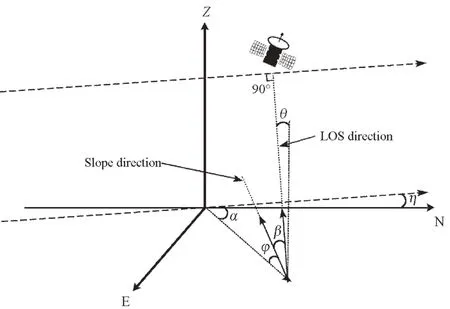
Because the deformation information monitored by SBAS-InSAR technology lies along the radar line of sight,and the sliding direction of a landslide is downward along the slope face,it is necessary to transform the deformation information along the line of sight into deformation information along the slope direction to express the real deformation situation in the landslide area (Zhang Shijia et al.,2018).Fig.1 shows that according to the slope and aspect of the landslide area,combined with the line of sight incident angle,the angle between the satellite flight direction and the positive north direction,the transformation of the deformation information along the line of sight direction to the deformation information along the slope direction can be completed.The transformation formula is as follows:

whereVLOSrepresents the deformation rate along the radar line of sight direction,VSLOPEstands for the deformation rate along the slope direction,β isthe angle between the -line of sight direction and the surface of the slope,i.e.,φis the slope of the slope;αthe aspect of the slope,θrepresents the incidence angle,andηrepresents the angle between the satellite orbit direction and the due north direction.

Figure 1 Geometric schematics of radar line of sight and slope direction(Cascini L.et al.,2010)
2 ANALYSIS AND VERIFICATION OF EXPERIMENTAL RESULTS
2.1 Overview of the Research Area and Experimental Data
In order to study the applicability of early landslide identification using SBAS-InSAR technology,the Jiangdingya landslide in Zhouqu County,Gansu Province,is selected as the research area,as shown in Fig.2.The Jiangdingya landslide is located on the left bank of the Bailong River,9 km away from Zhouqu County,with a height difference of 240 m and a mountain slope of nearly 50°,providing favorable terrain conditions for the occurrence of landslide disaster (Guo Changbao et al.,2019).The Jiangdingya landslide has experienced substantial slips,especially large-scale slips in 1991 (Mu Peng,2011) and 2018 (Guo Changbao et al.,2019),resulting in numerous secondary disasters and huge losses.
The SAR data used in the experiment are 84 Sentinel-1A ascending-orbit images provided by ESA.For its parameters,the imaging mode is interferometrically wide,the breadth is 250 km,the range resolution is 20 m,and the azimuth resolution is 5 m.The detailed parameters are shown in Table 1.The referenced digital elevation model (DEM) is SRTM DEM provided by NASA with a spatial resolution of 30 m.In addition,all the optical images used in this article are provided by Google Earth.The optical images in Fig.2(a) are Google Earth “Grade 13” images,while the optical images in Fig.2 (b) and Figs.5-8 are Google Earth “Grade 17” images.

Figure 2 Location of research area

Table 1 Parameters of Sentinel-1A ascending-orbit images
2.2 Analysis of Experimental Results
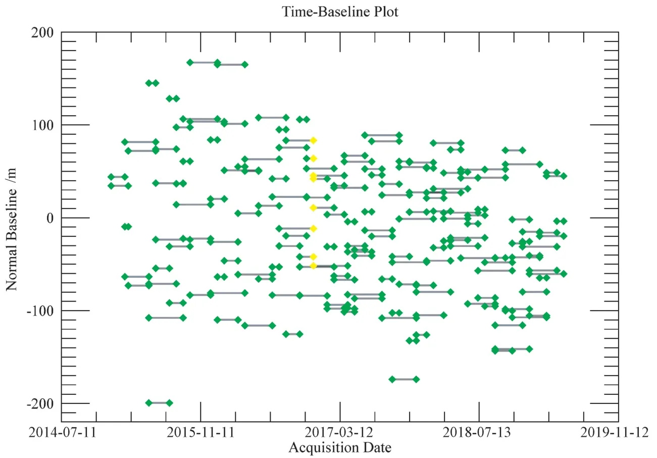
84 Sentinel-1A ascending-orbit images with a time baseline span of nearly 4 years are matched in sequence,resulting in 170 interference pairs.Among them,the average absolute space baseline is 58.419 m and the average absolute time baseline is 72.141 days.The image on December 9th,2016 is selected as the super main image.The time and image positions of all pairs are shown in Fig.3,and the time baseline and spatial baseline of all pairs are shown in Fig.4.
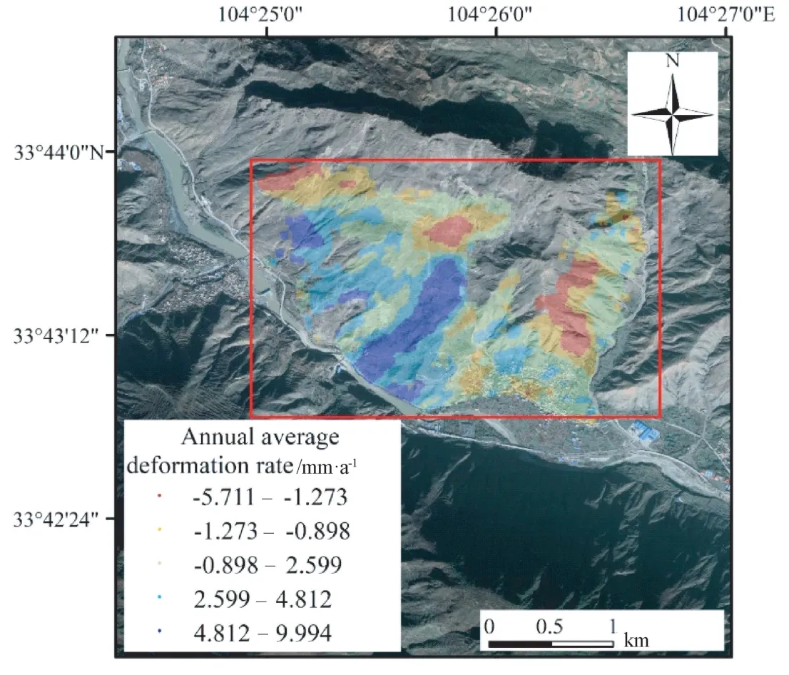
The surface deformation rate along the radar line of sight in the Jiangdingya landslide area from 2015 to 2019 is obtained based on SBAS-InSAR technology treatment,as shown in Fig.5,and the average surface deformation rate reaches -5.711—9.994 mm/a.The absolute value of the deformation rate indicates its magnitude information,and the positive and negative deformation rate indicate the direction of deformation.In detail,a negative value indicates that the deformation point moves along the satellite line of sight near the SAR direction,while a positive value indicates that the deformation point moves along the satellite line of sight away from the SAR direction.
Fig.5 shows that the deformation points are concentrated at the bottom,middle,and upper parts of the slope,where the terrain is rugged,the mountains are high,and the valleys are deep.Such regions are potential high-risk area for a landslide.The slope and aspect of the research area are extracted according to the reference DEM,and the transformation of deformation information along the line of sight to deformation information along the slope direction is completed by combining the incidence angle of the line of sight and the angle between the satellite flight direction and the positive north direction,as shown in Fig.6.In order to avoid exaggerating,the following information is observed:when -0.3< cosβ< 0,cosβ=-0.3,when 0 ≤cosβ< 0.3,cosβ=0.3 (Herrera G.et al.,2013).According to the results,the maximum average deformation rate of the landslide area along the slope direction in 2015-2019 is -31.750 mm/year.The negative value indicates the deformation point sliding down the slope.

Figure 3 Time and position of all image pairs

Figure 4 Time and space baselines of all image pairs

Figure 5 Surface deformation rate in line of sight from 2015 to 2019

Figure 6 Surface deformation rate in slope direction from 2015 to 2019
2.3 Verification of Experimental Results
The latest Jiangdingya landslide occurred on July 12th,2018.A large number of landslide bodies poured into the river channel with a total volume of approximately 10 000 m3,leading to the water level increase and the subsequent formation of a barrier lake(Guo Changbao et al.,2019).Fig.7 shows the deformation time series of the Jiangdingya area from 2015 to 2018 before the landslide.All deformations are cumulative deformation which refer to the date of January 1st,2015.Fig.7 shows that the surface deformation of the Jiangdingya landslide area gradually accelerates,and the seriously deformed area gradually increases.As of July 8th,2018,the maximum surface deformation in the main landslide area is 32.931 mm,and the surface deformation process in this area is consistent with the law of landslide body movement.

Figure 7 Deformation time series rate in line of sight
To further analyze the relationship between surface deformation and landslide movement in the Jiangdingya area,the annual average surface deformation rate of the region from January 2015 to May 2019 is obtained.In Fig.8,the red frame regions are those with serious deformation in the surface deformation monitoring results obtained using SBASInSAR technology.There are a large number of deformation points in this area,and the annual average deformation variable at the place with the largest deformation has a maximum value of 9.994 mm,indicating that this area is exactly where the Jiangdingya landslide is located.
At present,the four landslide revival areas in the Jiangdingya landslide area (shown in Fig.9) are still in a creeping state and are likely to resurrect again under the action of heavy rainfall and river erosion (Guo Changbao et al.,2019).The early identification results of the Jiangdingya landslide based on SBAS-InSAR technology are consistent with existing results,suggesting that SBAS-InSAR technology has high applicability in the early identification of landslides.

Figure 8 Surface deformation monitoring results of SBAS-InSAR based on ascending-orbit data
3 CONCLUSION
Landslides in the mountainous areas in western China are scattered over numerous places,most of which are located at high altitude.These regions are characterized by a slowly deformed surface after geological disasters Relying on traditional investigative methods,the investigation period is long and the risk coefficient is high; moreover,it is challenging to locate and provide early warning of potential landslide hazards in advance.Using the Jiangdingya landslide area as the study area,an examination on the effectiveness of identification of potential landslides based on SBAS-InSAR technology is conducted.In addition,with the support of a large number of long-term sequence ascending-orbit Sentinel-1A images from 2015 to 2019,the surface deformation information of this area is extracted,and the time series results of surface deformation are obtained,successfully identifying the Jiangdingya landslide.Compared with existing research results,the early identification method of landslide hazard based on SBAS-InSAR technology has high applicability and utilization value,which will considerably aid the early identification of landslides in large areas.
 Earthquake Research Advances2020年4期
- Earthquake Research Advances的其它文章
- Flow Characteristics of Large-Scale Liquefaction-Slip of the Loess Strata in Shibei Tableland,Guyuan City,Induced by the 1920 Haiyuan M8 Earthquake
- Dynamic Response of Double-Sided Loess Slope under Vehicle Load
- Dynamic Response of Shallow-Buried Tunnels Traversing High Loess Slopes
- Interpretation of the Spatial Distribution Characteristics of the Co-seismic Landslides Induced by the 1920 Haiyuan M8 Earthquake Using Remote Sensing Images1
- Relationship between the Landslides Triggered by the Tongwei M7 Earthquake in 1718 AD and the Disappearance of Yongning Ancient Town
- Impact of the Rainfall Intensity and Seepage on Slope Stability in Loess Plateau1
