
Mapping fisheries hot-spot and high-violated fishing areas in professional and recreational small-scale fisheries
2020-10-21 06:02DimitriosMoutopoulosGeorgeKtselisGeorgeProdromitisConstntinKoutsikopoulos
Aquaculture and Fisheries 2020年5期
Dimitrios K.Moutopoulos,George Ktselis,George Prodromitis,Constntin Koutsikopoulos
aTEI of Western Greece,Department of Fisheries-Aquaculture Technology,Mesolonghi 30200,Greece
bMinistry of Shipping and the Aegean,Hellenic Coast Guard,Peireaus 18510,Greece
cUniversity of Patras,Department of Biology,Rio-Patras 26500,Greece
ARTICLEINFO
Keywords:
Mapping fisheries restrictions
Fisheries infringements
Fisheries management enforcement
Mediterranean
ABSTRACT
The present study deals with the monitoring for a real implementation of management policies in marine environments and the potential con flicts between professional and recreational fishery in the coastal areas of the Mediterranean Sea.A comprehensive database of fishing effort and fisheries infringements from professional small-scale and recreational fisheries was screened to identify hotspots areas of fishing pressure in the coastal zones of Ionian Sea.Mapping points showed that the number of the recorded infringements conducted both by professional and recreational fishers are too low(1 and 6 recorded infringements per 104km2of vessel days per year)and that fishing effort,and subsequently the recorded infringements,are not evenly distributed but concentrated on specific fishing grounds.These revealed high-risk areas prone to illegal fishing activities and are implying problems in the implementation of the fisheries regulations rather than a low delinquency of the fishers to comply with the rules.Findings represents a step forward in applying tracking technology to the surveillance of small-scale fishery and are crucial towards the specification of the critical zones for setting an efficient control system.
1.Introduction
The intensification of fishing effort in order to surpass the poor state of fish stocks(Pauly&Zeller,2016)and the subsequently increase of illegal fishing(Miller,Bush,&Mol,2014)both convey a message of failure of the present management schemes(FAO,2014,p.223).The same is true for Mediterranean fisheries(Vasilakopoulos,Maravelias,&Tserpes,2014),in where traditional fisheries management failed to safeguard resources from over fishing(Colloca et al.,2011).On the other hand,the highly dispersed spatio-temporally fishing pressure on numerous fish species with contrasting life-histories pose difficulties in managing the Mediterranean resources(Stergiou,Moutopoulos,&Armenis,2009).
Marine Spatial Planning(MSP:EU,2013)sets the framework for the identification of the fishing activities within EU waters(Kavadas et al.,2015)through high resolution spatial fisheries.The identification of the spatial structure of fishing effort and fleet distributional patterns have been demonstrated especially for large-size vessels(larger than 12m)that are electronically monitored through Vessel Monitor System(VMS).However,a great part of the fleet(90% in Mediterranean waters)was not participated due to its small size(<12 m)(Russo et al.,2018).This is true when considering that Mediterranean coastal fisheries are traditionally small-scale operating from the vicinity of land within the 6 nautical miles of territory waters all year round(Kavadas et al.,2015).On the other hand,small-scale fishing is the dominant form of fishing in the world in terms of the number of people involved(Teh&Sumaila,2013)and the lack of data describing the spatial distribution and intensity of fishing effort of the small-scale fleet presents a challenge to managers(Enever,Lewin,Reese,&Hooper,2017).Additional problems of monitoring and patrolling of fishing activities for Mediterranean fisheries are the patchiness of fishing effort,the overlapping fishing activities between professional and recreational fishers and the high heterogeneous environment with the numerous islands and isolated small embayments.
However,a thorough compilation and mapping of all spatial restrictions to fishing is lacking and,thus,their extent and large-scale efficiency remains unknown.Despite its high socio-economic importance in the fisheries sector and local society(Tzanatos,Dimitriou,Katselis,Georgiadis&Koutsikopoulos 2006),small-scale fishery is,so far,unmapped due to the absence of obligation for keeping logbooks and of vessel identification systems such AIS or VMS(EC,2009a).Also,small-scale is not regulated through any spatio-temporal delineation of fishing grounds and it should be taken into account the increasingly popular recreational fishery(Giovos et al.,2018).Thus,there is a need for setting a spatial visualization of fishing activities and control efforts in Greek waters by taking also into account the coastal topography for a more realistic management approach.Previous efforts to spatially describe fishing activity was specially done for trawls(European waters:Eigaard et al.,2017;Adriatic:Russo et al.,2018;West Ionian:Russo et al.,2017;Greek waters:Maina et al.,2016,Maina,Kavadas,Damalas,Pantazi,&Katsanevakis,2018;Issaris et al.,2012)and smallscales(central Ionian Sea Kavadas et al.,2015).
This is the first study focused on the importance of effort controls,based on the recorded infringements,as the final end product of the enforcement of regulations in relation with the heterogeneity of the ecosystem topography as attributed through high spatial resolution maps.The present study spatially expands on Issaris et al.(2012)and Kavadas et al.(2015)by downscaling the frame in high detailed spatial units than the GSA level and by including the entire Greek Ionian Sea for all fishery compartments both for professional and recreational fishery.Thus,a spatial analysis of infractions for the professional smallscale and recreational fisheries were presented and compared with the fishing effort data visualized in high resolution national scale maps.Basic pillars of the study were to assess:(a)the footprint of small-scale fishery in the Greek Ionian Sea,(b)whether a pattern of fisheries infringements between protecting and unprotecting areas was existed,(c)the effectiveness of restricted fishing activities and to determine whether the existing boundaries are fir for purpose,and(d)to identify whether or not fishing effort changes across time were existed in protected or not areas.The above would re-enforce the validity of fisheries information a fact crucial for managers and conservation advisors as well as for optimizing fishing controls(Enever et al.,2017).
2.Materials and methods
2.1.Study area
Greek Ionian Sea(henceforth called Ionian Sea)hosts numerous anthropogenic activities such fish farming,protected areas,fishing activities(both recreational and professional),touristic activities and sensitive areas,such as Korinthiakos,Patraikos and Amvrakikos gulfs,marine protected areas(Zakynthos Island)and estuarine systems(Mesolonghi-Etolilkon lagoons)that all are under fisheries restrictive status for towing gears.Such Fishing Restricted Areas(FRAs)were characterized for the different levels of fishing intensity,from temporal closures of fisheries for certain fishing gears(trawl fishery is allowed only during winter in areas No.6 and 7)to the catholic,all year round,prohibition of towing gears(both for trawl and purse-seine fishery:areas Nos 14 and 16)(Fig.1).In addition,Ionian Sea includes important spawning areas for non-endangered,commercial demersal(i.e.hake,Merluccius merluccius:Politou,2007),small(i.e.sardine,Sardina pilchardus:Somarakis,Tsianis,Machias,&Stergiou,2006)and large(sword fish,Xiphias gladiusandThunnus thynnus:ICCAT,2003)pelagic fish species,as well as for marine megafauna,actively foraging on the continental shelf and interacting with local fisheries(i.e.monk seals:Karamanlidis et al.,2008;marine turtles:Margaritoulis et al.,2003;dolphins:Bearzi et al.,2010;Gonzalvo et al.,2016).
2.2.Data
Certain assumptions were made on the spatial fishing activity each vessel are engaged based on fishing gear types.Fishing effort data includes the number of fishing vessels and the number of annual fishing daysforthe professionalsmall-scale and recreational fisheries(Table 1).The number of the professional fishing fleet was based on the records from the Common Fisheries Register(CFR)during the study period(2012–2018).CFR is the official record of all Community fishing vessels based on the national registers of the EC Member States since 1991(EC,1998).For the Ionian Sea CFR database includes 40 fishing ports,which for they were aggregated in relation with the 16 port administrative units of the coast guard authorities that patrol the entire Ionian Sea(Table 1).Fishing days per unit of area for the professional small-scale fishery per area were derived from Tzanatos,Dimitriou,Katselis,Georgiadis,and Koutsikopoulos(2005).In this study,a total of 551 small-scale fishermen were on-the-spot interviewed at 121 ports in 18 out of the 40 coastal prefectures of Greece concerning their activity regarding the active days of fishing,fishing gear used and target species caught.Data of fishermen interviewed were derived from the Common Fisheries Register(CFR)and an attempt was made to include fishermen of different ages and from different generations.Number of recreational fleet per unit of area were derived from estimates on Keramidas,Dimarchopoulou,Pardalou,and Tsikliras(2018),whereas fishing activity of this fishery was approximated from the literature(60 days in annual basis:Moutopoulos,Tsikliras,&Stergiou,2015).
The jurisdiction zones of port authorities(JZPA)were estimated through the initial legislation that limits the administrative area units of each port authority from the coastline,leaving apart lagoons,archeological areas and 200 m distance from the fish farm units(Table 1)and up to six miles territorial waters that has been considered as potential fishing ground of small-scale fishery.Map templates also visualized the FRAs for the spatial-temporal restrictions for trawls and purse-seine fisheries(Fig.1).
Data on fisheries infringements were recorded across Ionian Seas from 20 coast guard port authorities(Table 1)under the jurisdiction of Ministry of Mercantile Marine and the Direction of Fisheries Control and were disaggregated per custom port authority and fishery type(i.e.trawl,purse seine,beach seine,small-scale gears,miscellaneous infringements of the professional fishery,recreational,snorkeling and use o'f illegal fishing methods)for the period during 2012–2018.Fishing infringement is de fined as such in relevant Union law(article 42(1)of EC No 1005/EC,2008b and in article 90(1)of EC No 1224/2009a).
The procedure of the inspection of the fishing activity begins as soon as the patrol vessel reaches the illegal fishermen/vessel.The number of inspections,as well as the frequency of controls,per port authority was not to our knowledge available and these are depended on the number of personnel and the availability or not of a patrol vessel per port authority.During patrolling,custom port authorities in each port of their jurisdiction are randomly sampled on different types of fishing vessels depending on the number of vessels per fishery reported in CFR for each port.In cases that a prohibited fishing gear is found on the vessel,then both the fishing vessel and the catch are seized and the illegal fishermen were prosecuted,questioned by the Port Authority Judiciary and will be released until the Port Authority Chief issues the appropriate fine depending on the infringement.In cases of illegal fishing due to the absence of the appropriate licenses(both for the professional and recreational fishery)the guard authorities should be decided which procedure to follow;by recording a simple infringement with the lowest fine(i.e.,300 euro)or not recording the infringement.
3.Results
Table 2 presented the estimated fishing effort per surface area,of the recorded infringements per surface area and of the recorded infringements per fishing effort for the professional small-scale and recreational fisheries for the period 2012–2018.Fishing effort(number of vessels x annual number of fishing days:ves.days)per surface area for the combined estimates for the professional small-scale and recreational fisheries and for each fishery separately was highest in the enclosed gulfs of the Ionian Sea;Amvrakikos and in the outer area of Preveza and in Patraikos and to a lesser extend in the Gulf of Corinth and Lefkada Island(Fig.2).Likewise,the recorded infringements per surface area for the professional and recreational fisheries were highest in the gulfs of Amvrakikos and the outer area of Preveza and in the Patraikos gulf and to a lesser extend in Mesolonghi area(Fig.3).

Fig.1.Local fisheries restrictions for the Greek Ionian Sea and jurisdiction-zones of port authorities.Code number in parenthesis indicates port authorities listed in Table 1.
The regression between the fishing effort to the number of infringementspersurfacearea showed thatboth relationswere significantly(P<0.05)positive linear with one and six infringements per 104ves.days recorded for the professional and recreational fishery,respectively(Fig.4).Spatially,few exceptions were marked as outliers for each fishery,such as Itea,Lefkada Island and Mesolonghi for the fishing activities of the professional fishery(Fig.4a)and Corfu Island,Korinthiakos gulf and Katakolo for the recreational fishery(Fig.4b).Temporarily,the seasonal distribution of the fisheries infringements per area was significantly(chi-square test:χ2=5.23;df=45;P< 0.05)different between professional and recreational fishery(Fig.5).In fact,during summer almost half of the annual recorded infringements for the recreational fishery conducted during summer(Fig.5a),whereas the corresponding one for the professional small-scale fishery was about 33%(Fig.5b).The inverse was true during winter,when almost 1/5 of the infringements for the small-scale fishery were conducted during winter,whereas the respectively one for recreational fishery is almost minimal(6%:Fig.5a).
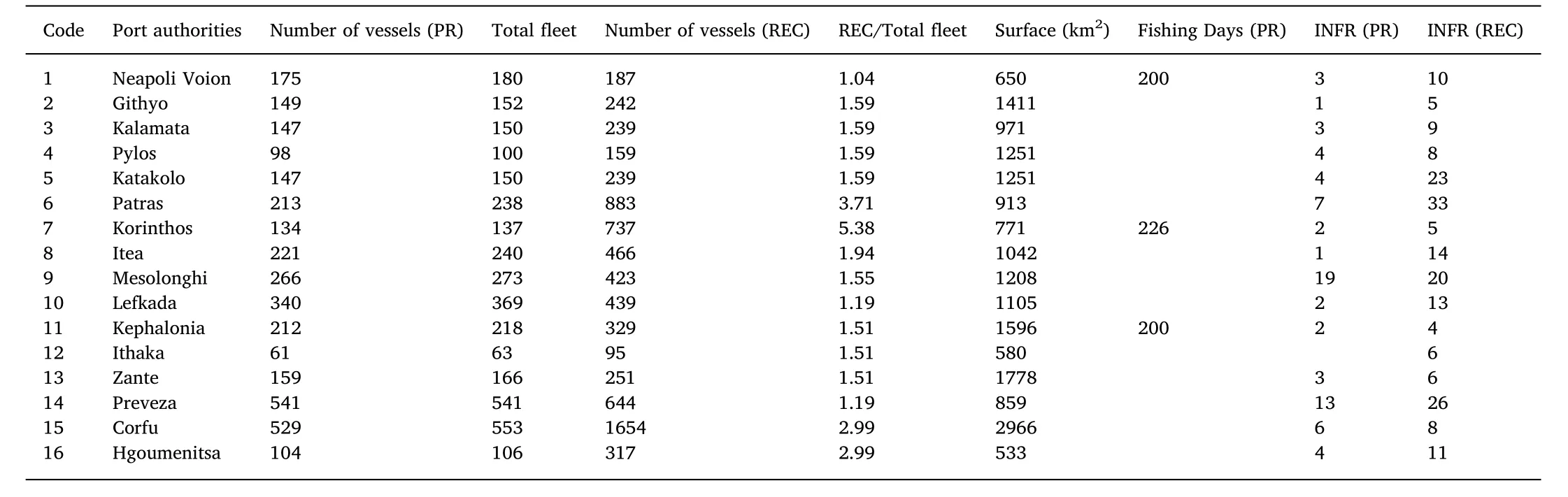
Table 1Port authorities,number of fishing vessels(PR,professional and REC,recreational small-scales),total fleet,ratio of the recreational to all fishing vessels,number of fishing days in annual basis and recorded infringements(INFR)per fishery.
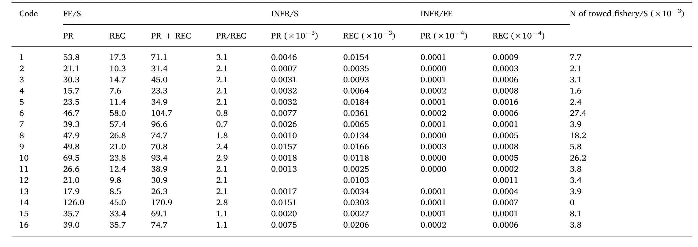
Table 2Fishing effort per surface area(FE/S),recorded infringements per surface area(INFR/S),recorded infringements per fishing effort(INFR/FE)and number of vessels for towed fishery per surface area(N of towed fishery/S)for the sum of trawl,purse-seine and beach-seine vessels.PR is the professional and REC recreational smallscales.Code number indicates port authorities listed in Table 1.
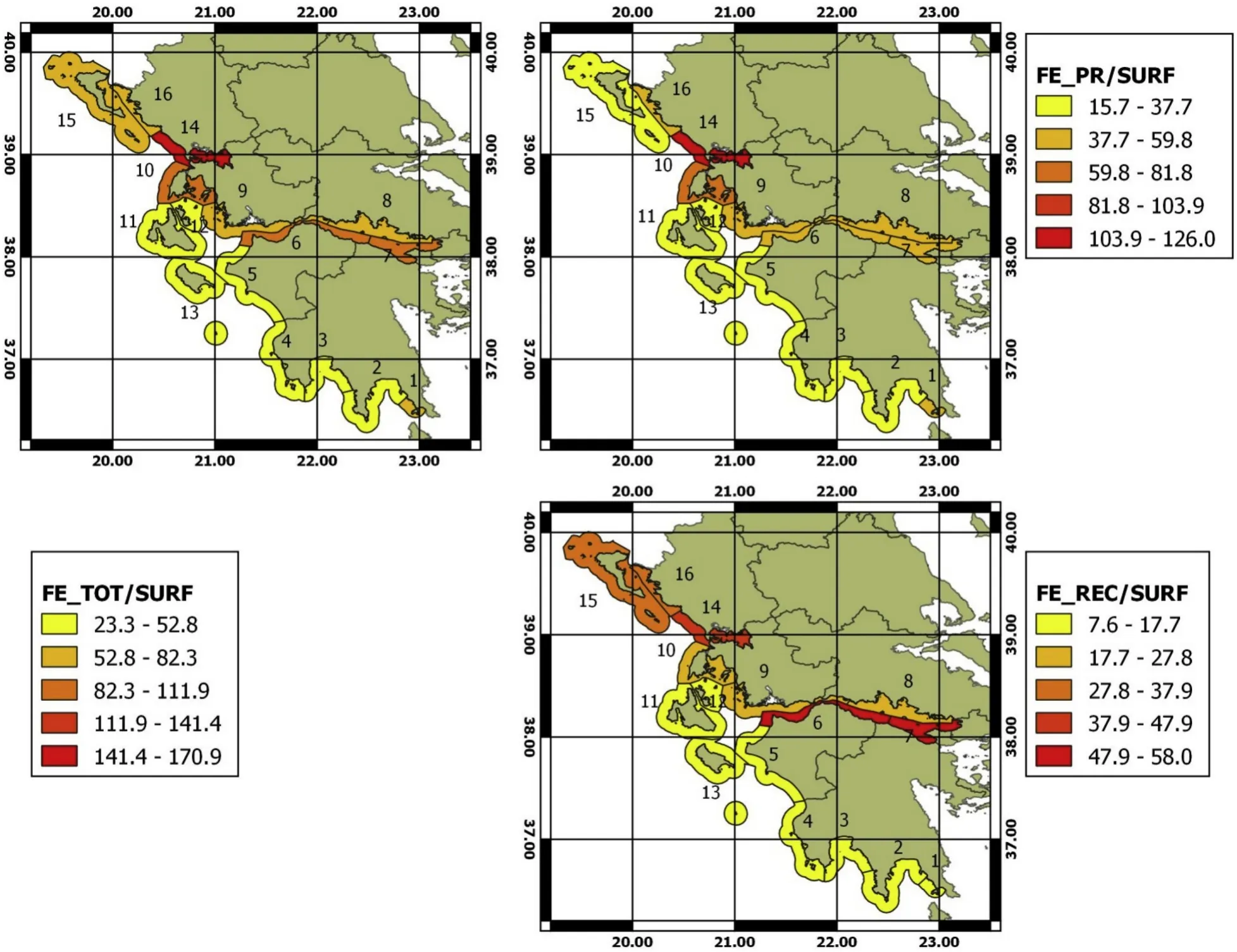
Fig.2.Fishing effort(number of annual fishing days with number of vessels)per surface area for the professional small-scale(PR),recreational(REC)and combined data(PR+REC).Code number in parenthesis indicates port authorities listed in Table 1.FE_X/SURF is the number of Vessels*Days per surface area and year,where X:PR=Professional,REC:Recreational or TOT=PR+REC.
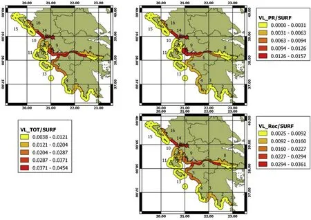
Fig.3.Number of recorded infringements per surface area for the professionalsmall-scale (PR),recreational(REC)and combined data(PR+REC).Code number in parenthesis indicates port authorities listed in Table 1.VL_X/SURF is the number of infringements per surface area and year,where X:PR=Professional,REC:Recreational or TOT=PR+REC.
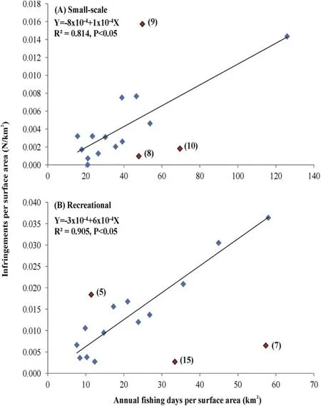
Fig.4.Regression of the ratios between fishing effort per surface area(in km2)and recorded infringements per surface area for:(a)professional small-scale and(b)recreational fishery.Code number in parenthesis indicates port authorities listed in Table 1.
4.Discussion
In the present study both fishing effort and control records were screened to identify hot-spots areas for legal and illegal fisheries of the professional and recreational small-scale fisheries.Data used suffer from certain limitations due to the lack of information on the effective efforts conducted by the authorities to control the law implementation in each one of the Greek Ionian Areas studied.In fact,there is a lack of information about the frequency of the fishing controls and the time spent at sea by coast guard authorities,the real operational capacity of local coast guard authorities and the personal details of the fisherman/vessel committed a violation.Although further research effort should enhance the reliability of our arguments to identify whether or not the in-forced legislation are respected,we consider that the present study provided an important first step to considering cumulative impacts of human activities in marine environments and sheds light on critical aspects affecting the implementation of fisheries regulations.
What is more striking from the present study is that:(a)the number of the recorded infringements conducted both by professional and recreational fishers are too low(1 and 6 recorded infringements per 104of ves.days),(b)the recorded number of infringements conducted for the recreational fishery is more than doubled compared with the professional ones and(c) fishing effort,and subsequently the recorded infringements,are not evenly distributed in spatial terms but are concentrated on specific fishing grounds.
The very low recorded infringements,which were conservatively estimated from the mean number of fishing days per fishery,has been also observed both in developing and wealthy countries(Arias,2015)indicating problems in the implementation of the fisheries regulations rather than a low delinquency of the fishers to comply with the rules.Weak control might be attributed to the high transparency of patrol authority’duties,mostly because these are allocated on refugee-human smuggling problems than on fishing operations.Control authorities are also responsible for marine safety and security for the tourists especially during summertime,when recreational activity,both legal and illegal ones,is peaked(50% of the annual infringement was recorded during summer:Fig.4a).These issues when complemented with the problems raised by the financial crisis occurred in Greece during the last decade intensively limited coast guard operational efficiency(i.e.limited expenses for gas and personnel).
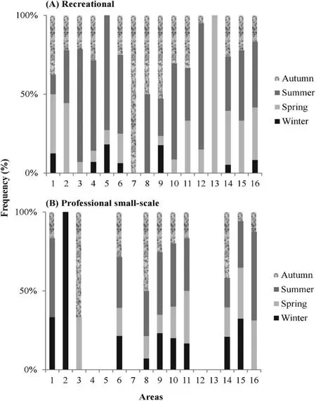
Fig.5.Seasonal percentage distribution of fisheries infringements for:(a)professional small-scale and(b)recreational fishery in Greek Ionian waters.Code number in parenthesis indicates port authorities listed in Table 1.
Assuming that enforcement efforts are spatially lacking along the Ionian waters,thus,only assumptions can be made regarding the spatial allocation of the recorded infringements.The higher infringement concentration on enclosed fishing restricted areas(FRAs)such as(Fig.1);Korinthiakos(No 7),Patraikos(No 6),Amvrakikos(No 14)and Hgoumenitsa strait(No 16)could be related either to enforcement management policies(e.g.closures)and/or to the town proximity.A merit of the proposed visualization of hot-spot areas of fishing activities in the Ionian Sea(GSA-20)is that these shallow enclosed areas act as nursery grounds for many fish species.Coastline topography could also determine the intense of the recorded infringements both for smallscale and recreational fisheries(areas No 4 and No 5:Figs.1 and 2),in where despite the low degree of fishing effort,a high number of recorded infringements were emerged for both fisheries.This is the case for the coastal guard authorities in the south-eastern part of the Ionian Sea(areas Nos 1 to 4)that were characterized by large sea areas with extensive coastline,easily accessible for fishing and remote from a limited number of coastal guard authorities.
Easy access to illegal fishing triggers people towards distructive fishing activities,such as the use of explosives,both for the people involved and for the ecosystem(area No 5),enhancing the conflict between different categories of fishers (Gonzalvo,Giovos,&Moutopoulos,2015;Tzanatos et al.,2006)and largely increase the cost of monitoring and reduce the effectiveness of fishing control.The easy accessibility to well-known fishing grounds,which is affecting fuel consumption,is of the most significant drivers that trigger fishers towards illegal fishing,where a quick and unnoticed return to homeport were “guaranteed” (Moutopoulos, Prodromitis, Mantzouni, &Koutsikopoulos,2016).
Another factor that might reduce the effectiveness of patrolling could be the size of the local professional fishing fleet and the technical characteristics of the vessels per each fishery involved.In fact,areas No 8 and No 10(Fig.2)were exhibited the lowest values of the recorded infringements to fishing effort ratios for the professional small-scale fishery.These are small towns with high number of large fishing vessels using towed gears(see column of“N towed fishery/S”in Table 2).This fleet pattern observed is comparable only with big Ionian ports,such as the big city of Patras.It seemed that in these areas the intensity of patrolling might be dispersed among the high number of fishing vessels and fishery compartments and focused on the towed fishing gear that are spatio-temporality prohibited in these two areas(area No 10:no take zone for trawl and purse-seine:Fig.1).The degree of detection of the professional illegal fishing might be also reduced by the highest duration of the fishing trip conducted by the small-scale fisher in area No 10 compared with corresponding one estimated in the other Ionian areas(4.5 h vs 2.6,respectively:Tzanatos et al.,2006).It can be considered that long trips carried out by the professional small-scale fishers might reduce the possibility to be detected and controlled by the patrol authorities in case of illegal fishery.
In contrast,in a lagoon protected area(No 9)the highest ratio of the recorded infringements for the small-scale fishery(Table 2)were attributed to the illegally fishing conducted within the protected area of the lagoons using prohibited fishing gears such as netters(Moutopoulos,Dimitriou,Katselis,&Koutsikopoulos,2017).Causes for this phenomenon are the lack of mooring ports for the professional vessels and the technical characteristics of the local professional fleet.With respect to the former,the access to illegal fishing is easy for those not having a fishing/vessel licenses and,thus,highly increase the sense of impunity.Also,the small size of the local fleet that is fully adapted to the heterogeneity of the ecosystem(muddy bottoms of mean depth of 0.8 m)(Koutrakis et al.,2007)limited fishing operation to the open sea and thus increase the opportunity to fish illegally within the protected area.
Recreational activity exhibited the highest number of recorded infringements showing that this activity may represent a cost-effective target for the patrol authorities to be detected and monitored due to easy access of activity in close proximity to the coastline and of simple administrative burden.However,the difference in the degree of control intensity occurred between professionals and recreationals consist of the main issue of debate among them(Gonzalvo et al.,2015),especially in areas of high number of recreational fishers(Korinthiakos gulf-area No7:Anonymous,2008a,and AmvrakikosGulf-areaNo14:Anonymous,2008b).
Con flicts of activities between professional and recreational fishers have been also depicted by the regression plots of the fishing effort data with the recorded infringements per fishery.There are “hot-spot”fishing areas located in insular,very popular touristic areas and in close proximity to big cities(areas Nos 6,7,8,14 and 15:in Figs.1 and 2),certain of which were exhibited low recorded infringements(areas Nos 7,8 and 15).It seemed that the high concentration of recreational fishers in these areas,in where recreational fishing vessels outnumber professional ones by a factor of three(Keramidas et al.,2018),acts as a catholic factor for immunity against controls from the patrol authorities,fact that increases the strong con flicts between professionals and recreationals as declared by the professionals through personal interviews(Korinthiakos gulf-area No 7:Anonymous,2008a).Historically,the concentration of a 6-fold higher number of recreational fishers in area No 7(Fig.1)has been also con firmed by studies 30 years ago(Stergiou&Papaconstantinou,1987)enhancing the traditional role of the recreational fishery.
A suggestion for regulating recreational fishing in these restricted and ecologically important areas towards the sustainability of fish stocks might be the harmonization of the legislation with rules change regularly according to importance of each area,such as for instance a spatial closure also for this type of fishery.An additional measure especially during periods of peaked fishing activity might be mandatory logbooks for recreational fishers(Hyder et al.,2017).Robust control effort is critical to maintain compliance(Kelaher et al.,2015),but the Greek finance crisis downgrading the level of compliance.This situation might be reversed through a link between enforcement and community engagement that are offering a cost-effective way to improve the effectiveness of enforcement(Bergseth,Williamson,Russ,Sutton,&Cinner,2017).
The complex fisheries compartmentation of the Mediterranean fisheries reduces scientific results and weakens management decisions.Mapping hotspots of fishing pressure based on fishing activities could provide an important application for data-poor and multi-gear fisheries areas in order to implement an efficient control system for better implementation of the management plans to achieve sustainability(Horta e Costa,Erzini,Caselle,Folhas,&Gonçalves,2013).In future steps the present work can be enhanced with additional environmental data such as bottom type and sediment characteristics(Issaris et al.,2012)and socio-economic factors such as fuel consumption(Guillen,Cheilari,Damalas,&Barbas,2015)and market demand(Giovos et al.,2019 in press),as well as the involvement of fishermen knowledge in the development of effort maps(Enever et al.,2017)in order to explicit their spatial usage against competing activities.
 Aquaculture and Fisheries2020年5期
- Aquaculture and Fisheries的其它文章
- Fish assemblages in protected seagrass habitats:Assessing fish abundance and diversity in no-take marine reserves and fished areas
- Assessment of faunal communities and habitat use within a shallow water system using non-invasive BRUVs methodology
- Assessing potential protection effects on commercial fish species in a Cuban MPA
- Estimation of age and growth and mortality parameters of the sea cucumber Isostichopus fuscus(Ludwig,1875)and implications for the management of its fishery in the Galapagos Marine Reserve
- The role of marine protected areas in sustaining fisheries: The case of the National Park of Banc d’Arguin,Mauritania
- Fisher's perceptions about a marine protected area over time