
Validation of AIRS-Retrieved atmospheric temperature data over the Taklimakan Desert
2020-09-24 05:53YuFenMaRuQiLiMenZhangMinZhongWangMamtiminAli
YuFen Ma,RuQi Li,Men Zhang,MinZhong Wang,Mamtimin Ali*
1.Institute of Desert Meteorology,China Meteorological Administration,Urumqi,Xinjiang 830002,China
2.Center of Central Asia Atmospheric Science Research,Urumqi,Xinjiang 830002,China
3.Xinjiang Meteorological Observatory,Urumqi,Xinjiang 830002,China
ABSTRACT
Keywords:AIRS;Taklimakan Desert;temperature;quality validation
1 Introduction
The Taklimakan Desert is the second largest desert in the world, playing an important role in regional climate change as well as the water cycle due to its location and land use category(Li,1991).First,this desert is located in the Tarim Basin bordered by the Tibetan Plateau to the south and the Tianshan Mountains to the north.Due to its expansive desert land surface and limited oasis area, there are only seven conventional sounding sites in the Taklimakan Desert and none at its center,which is not enough to precisely and quantitatively evaluate the spatial and temporal variation of the temperature.Previous studies on Taklimakan Desert temperatures have been conducted based on the observations from an 80-m observation tower (Liu,2016;Wang,2016),and others have utilized the available soundings or ground-based GPS (Cui, 2012).All of these works are limited to a specific part of the desert or to near-surface layers because of limited observations.It is therefore necessary to search for other means by which to research the general temperature variation at high spatial and temporal resolutions, and remote sensing data from satellites, together with numerical models, are essential.The global atmospheric temperature datasets from satellites can only significantly improve the numerical precision when the data quality is equal to that of conventional ground-based radiosondes (Fredrick, 1996).However, TOV and ATOVS fail to meet this standard due to their passive detection technology (Kim Met al., 2017), making it difficult to improve their vertical and spatial resolution.It is also challenging to greatly improve the vertical detection ability of a microwave profiler because of its extensive volume and mass as well as its weak power of microwave radiation, which consumes considerably more energy than infrared instruments.Therefore, a high-resolution infrared detector is preferably.The precision of temperature detected by satellites can match that of radiosonde observations when its spectral resolution is greater than 1,000 and its radiometric accuracy is better than 0.2 K (Wang, 2013).The spectrum resolution of the current HIRS and GEO-Sounder operational detector is only 50-200 km,with a vertical resolution of 3-5 km, which does not meet the qualifications.
The Aqua satellite is the second EOS satellite launched by NASA and is equipped with atmospheric infrared detectors (http://eosdata.gsfc.nasa.gov/atmodyn/airs/airs-documentation.html).Atmospheric Infrared Sounder (AIRS) data in the 3.7 to 15.4 micron range have 2,378 spectral channels with a high vertical resolution of 1 km and a ground resolution of 13.5 km,enabling the retrieval of accurate atmospheric temperature and humidity profiles penetrating through clouds with a combination of advanced microwave detectors (AMSU) and humidity detectors(HSB) (Aumann, 2003; Susskind, 2003).AIRS began its normal operation in September 2002 and has gradually become the mainstream detector of vertical atmospheric sounding in recent years.Gettelman(2004)found that the datasets are mostly non-biased and the air temperature above 100 hPa has a standard error of approximately 25%.AIRS inversion in the upper troposphere has high accuracy, while the accuracy is lower in the lower troposphere, especially near the ground (Parkinson, 2003), and the retrieval precision near the ground can be improved (Liu, 2008) to increase the surface emissivity and terrain prediction factor.Therefore, the quality detection of air temperature and humidity products in an area with high land surface emissivity and high variation such as the Taklimakan Desert areas is particularly important.
Limited previous research has been done on the retrieval precision of AIRS retried air temperature.Fredrick (1996) validated the version 6 retrievals of AIRS temperature, water vapor and cloud datasets are capable to obtain a general knowledge of atmospheric temperature and humidity structure globally.Validation of AIRS and IASI Temperature and Water Vapor Retrievals with Global Radiosonde Measurements and Model Forecasts has also been conducted for its further use in weather analysis.Research has been done on the retrieval precision over complex terrain (Zhan, 2008),but no studies have investigated the effects of desert land use or basin terrain on the retrieval precision,which is the focus of the present study.
In this paper, the AIRS temperature retrievals were compared with those of radiosonde observations(RAOBs), including seven routine sounding observations in oases around the Taklimakan Desert and one from a field experiment in July 2017 in the center of the desert.The differences in retrieval precision were also compared between desert and oases as well as between morning(07:00-10:00)and dusk(19:00-22:00).
2 Data and methods
2.1 Data
The following three datasets, covering a period of 30 d(July 1 to 30,2017),were used for this study:
(1)The temperature profiles of level 2 products of the AIRS mounted on the National Aeronautics and Space Administration (NASA)/Aqua satellite.In this paper, level 2 data were used, which are a retrieval product created using AIRSIR and AMSU without-HSB.Its temperature products have 28 standard layers ranging from 1,100 to 0.1 hPa and a horizontal resolution of 1°×1°.
(2) The temperature data of 7 RAOB stations over the oases around the Taklimakan Desert were collected.After being revised, the data passed the homogeneity test.In this study,seven RAOB stations over the Taklimakan Desert,situated between 35°N-43°N and 73°E-90°E and at altitudes higher than 1,500 m above sea level, were selected.Vertical profiles of the temperature were preprocessed to 28 standard pressure layers similar to the AIRS retrievals used in this study.A log of the temperature data above 200 hPa was missing,and as the altitudes of the selected stations range from 888.3 m to 1,409.3 m, 850 hPa was considered as the lowest level of the basin, which was also necessary for statistical comparisons of the temperature at these altitudes.Figure 1 shows the geophysical distribution of the RAOB stations, with their topographic altitude in Figure 1a and land-use category in Figure 1b.The land use classes are from USGS data(Sertel,2010).
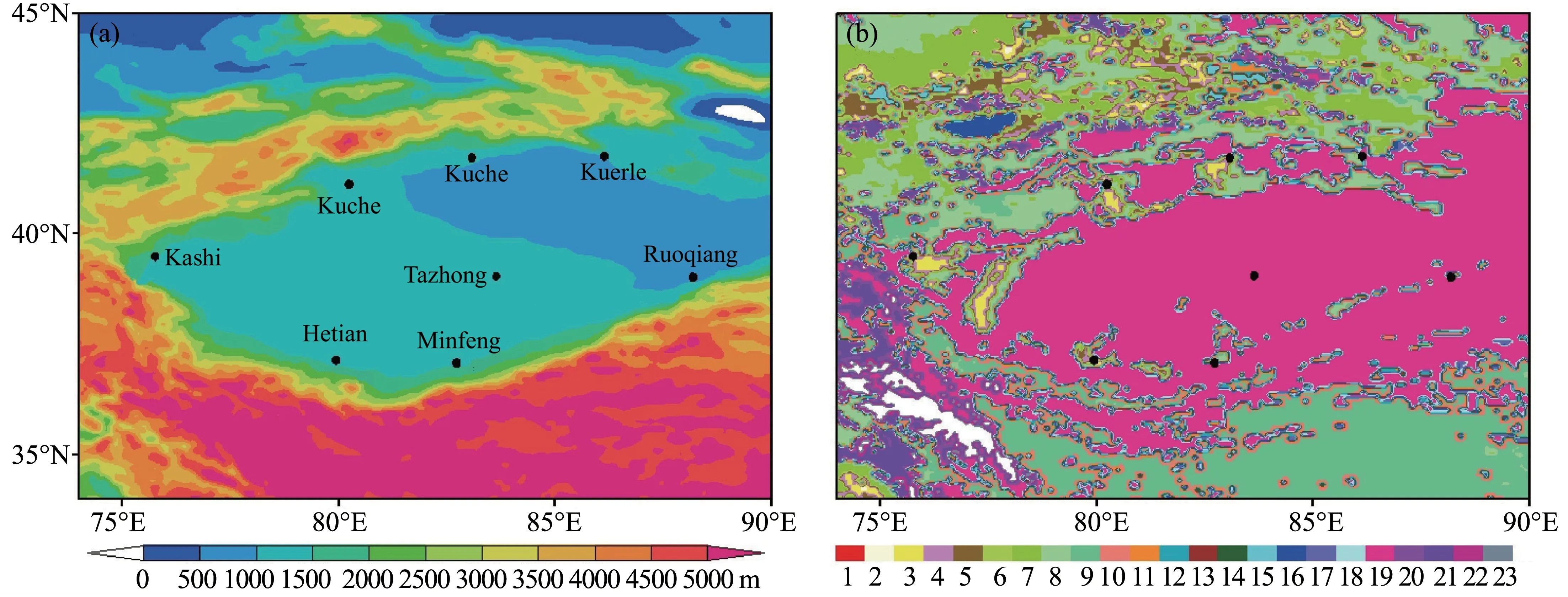
Figure 1 Spatial distribution of the RAOB stations(black dots)in the Taklimakan Desert with their topographic altitude(a)and land-use categories(b)
(3) The field sounding data in the center of the Taklimakan Desert are from the Tazhong meteorology station marked in Figure 1a.The experimental radiosondes are equipped with a GPS sounding system and radiation detection system, with meteorological factors consisting of air temperature, humidity, air pressure, wind direction, and wind velocity as the detection targets.The temperature profile is even more precise than that from routine radiosonde sites and can be used for the validation of AIRS retrievals.Notably,due to the fact that the field sounding experiments at the Tazhong meteorology station lasted for only one month,all the datasets used in this study are thus confined to this month and may require further collocation and validation.
2.2 Methods
In this study, the water vapor mixing ratio was computed based on the temperature and dew point temperature data.Water is present atT≥0 °C and ice atT≤ -20 °C, with ice and water coexisting in the temperature range from 0 to-20°C(Goff and Gratch,1946).The AIRS retrieval data were compared with the RAOB data to determine the differences between them.Then, the correlation coefficient and root mean square error (RMSE), as well as BIAS, were computed to quantitatively evaluate the differences between them in the morning and at the night.The BIAS here is defined as follows:

RMSE is calculated as follows:
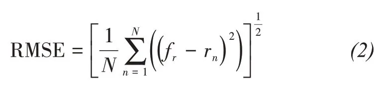
whererandnindicate the retrieval and sounding time, respectively, andfrandrnare the retrieval and sounding temperatures,respectively.
In addition, the eight selected RAOB stations were divided into three groups according to their land-surface conditions, as shown in Figure 1b.The first group is desert RAOB, which is Tazhong Station.The second group is small-scale oasis RAOB, including Ruoqiang and Minfeng, as well as Hetian stations.The last group is large-scale oasis RAOB,containing 4 stations:Kashi,Aksu,Kuche and Korla.
3 Results and discussion
3.1 Profile collocation and validation
Comparison of land-surface temperature between observations from conventional land-based meteorological stations and retrievals of AIRSshow that the majority of the retrieval errors are systematic errors and that topography is the dominant factor, which also partly comes from different land-use categories.
The obvious negative biases in the morning have been proven to be related to hot convection in the hinterland of the Taklimakan Desert(Figure 2).Deep and hot convection can be easily generated by strong landrelated long-wave radiation from the desert hinterland under clear-sky conditions, and this convection can reach upper air levels at altitudes of 5,000 m.The estimates of such convection were underestimated by the AIRS retrievals, which further induced the negative bias in the retrieved air temperature.In addition, due to the exceptionally low water content in the upper air above 200 hPa, the temperature decreases more rapidly than is estimated by the AIRS retrievals,which contributes to the positive biases of the AIRS retrieval temperature compared to conventional sounding temperature.

Figure 2 Comparison of air temperature data from radiosonde observations and AIRS at a sounding site in Tazhong in the desert
At dusk, the solar short-wave radiation becomes weaker as the temperature gradually decreases.However, the land-surface temperature is still rather high due to strong sunshine during daytime, and the lower-level air is still being heating at this moment.Meanwhile, since the Tazhong meteorological station is located in the center of the Tarim Basin, as presented in Figure 1a,the heat there cannot spread away immediately.Energy is thus concentrated in the lower atmospheric layer, which maintains a higher temperature similar to that at noon below 700 hPa, and the temperature reduction rate in the lower atmospheric layer is low.However,the AIRS retrieval products underestimate such heating effect from land-originating emissions and the energy-gathering effect of the large basin, further producing a negative bias between retrieval temperatures and soundings.Furthermore, the sounding temperature decreases dramatically with altitudes above 700 hPa due to the low specific heat capacity of the dry atmosphere.The AIRS retrieval temperature is higher than the sounding temperature in layers from 200-700 hPa while lower than the sounding temperature above 200 hPa.Both in the morning and at dusk, the altitude of the lowest temperature in both the AIRS retrievals and soundings is similar, approximately 70 hPa.However, relative to sounding temperatures, the AIRS retrieval temperatures are higher in the morning, lower at dusk, and lower near the land surface at both time.
The AIRS retrieval temperatures are consistent with sounding temperatures from the meteorological stations in the hinterland of the Taklimakan Desert at both times, except for an obvious positive bias in the AIRS retrieval temperatures below 500 hPa over stations in small-scale oases in the morning(Figure 3).
For the four meteorological stations in the large-scale oasis (Figure 4), the AIRS retrieved and sounding temperature agree well at both times over Kashi and Kuche, while the retrieval temperature is significantly lower than the sounding temperature during daytime due to the topography.Therefore, the AIRS retrieval temperatures perform better in the large-scale oasis in the Taklimakan Desert than in the small-scale oasis and hinterland of the desert.
Generally speaking, the AIRS retrieval temperature profiles throughout the entire Tarim Basin agree well with sounding temperature profiles, except at the Tazhong station in the hinterland of the desert and the Ruoqiang station in the small oasis.Over the Tazhong Station, the retrieval temperature is negatively biased above 200 hPa and positively biased in the morning.Furthermore, it is positively between 700 hPa and 200 hPa and negatively biased in the other layers.The AIRS retrieved maximum (minimum) temperature is on average lower (higher) than the radiosonde temperature from the eight selected meteorological stations.
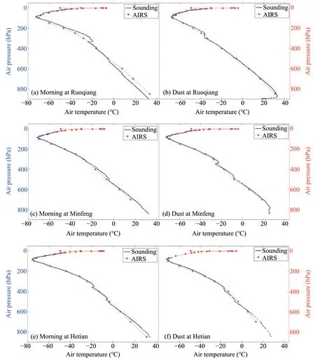
Figure 3 Comparison of air temperatures from radiosonde observations and AIRS over sounding sites in small-scale oases
3.2 Vertical variations in level mean differences
Figure 5a shows the temperature correlation coefficients between AIRS and RAOB in the morning(black line)and at dusk(red line).Both correlation coefficients decrease with an increase in altitude, with values ranging from 0.2 near 50 hPa to 0.9 at lower levels.The pattern of changes with altitude varies.In the morning,the maximum coefficient appeared at approximately 250 hPa, higher than that near 700 hPa,and a sudden drop of this value occurred from 100 hPa to 50 hPa while remaining approximately stable below 100 hPa.In comparison, the correlation coefficient at dusk had a minimum at 50 hPa and a maximum at approximately 600 hPa, and the curve generally decreases with altitude.The correlation coefficient of temperature in the morning is only greater than that at dusk between 450 hPa and 550 hPa but is smaller or equal to that at dusk elsewhere.
Figure 5b shows the temperature RMSE between AIRS and RAOB in the morning (black line) and at dusk (red line).The RMSE profiles are similar to each other, with the tendency to generally decrease with altitude below 150 hPa and increase above.The majority of RMSE values in the morning are smaller than those at dusk, indicating that the AIRS retrieval temperatures have better consistency in the morning than at dusk, while they are better over the middle layers between 700 hPa and 150 hPa than above 150 hPa.The obvious errors might be mainly due to the intense land-surface emissivity during the sunshine period in the Taklimakan, while the largeerror above 150 hPa may arise from the horizontal shift in the locations of sounding balloons caused by high-speed winds in the upper troposphere or lower stratosphere.
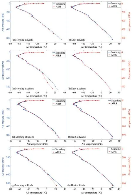
Figure 4 Comparison of air temperatures from radiosonde observations and AIRS over sounding sites in large-scale oases
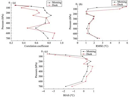
Figure 5 Vertical profiles of the correlation coefficients(a),RMSE(b)and BIAS(c)between the AIRS retrieval temperature and RAOB observations over the Taklimakan Desert in the morning(black line)and at dusk(red line)
Figure 6c shows the temperature BIAS between AIRS and RAOB in the morning (black line) and at dusk (red line).Three main features are revealed in this figure.First, the pattern of change with altitude is similar during morning and dusk: it increases with altitude below 200 hPa while decreasing above.Second, the BIAS in the morning is smaller than that at dusk below 300 hPa but is greater above 250 hPa.Thirdly, the BIAS value in the morning is positive in the middle layers between 500 hPa and 150 hPa and negative above 150 hPa and below 500 hPa, while its value at dusk is positive in the middle layer between 600 hPa and 150 hPa and negative above 150 hPa and below 600 hPa.
Due to the cloud check process and considerable bias caused by land-surface emissivity in the retrieval calculation from AIRS radiance,much of the temperature data below 700 hPa over the Taklimakan Desert was filtered out, which is why the analysis results below 700 hPa are not discussed in this study.
3.3 Mean difference for entire layers
The correlation coefficients and RMSE, as well as the mean BIAS, between the AIRS retrievals and RAOB data are discussed and analyzed in this section.
The correlation coefficients between the AIRS and the RAOB temperature data in the Taklimakan Desert in the morning (Figure 6a) shows that, first,the correlations are all obvious over the selected stations, indicating that the AIRS retrievals are consistent with RAOBs, and the entire Taklimakan Desert has passed the significant test at the 0.05 significance level.Second, the correlation coefficients over desert sites and those sites in small-scale oases are greater than those over large-scale oases in the morning.
The correlation coefficients between the AIRS and the RAOB temperature data in the Taklimakan Desert at dusk(Figure 6b)show that,first,the correlations are close over the oasis stations at dusk but negatively correlated with RAOBs, which indicates that the AIRS retrievals are closely consistent with RAOBs over oases at dusk but are not well correlated over desert sites.Second, the correlation coefficients over desert sites and those in small-scale oases are smaller than those over large-scale oases at dusk,which is opposite to the situation in the morning.
In addition,a comparison of AIRS-RAOB correlation coefficients between morning (Figure 6a) and dusk (Figure 6b) shows that the correlation coefficients over the large-scale oases in the morning are smaller than that at dusk, while those over the smallscale oases in the morning are greater than that at dusk.The most significant difference occurs over Ta-zhong,a central desert site,with a value of 0.75 in the morning but -0.08 at dusk, indicating that the desert land surface imposes an obvious impact on temperature.According to a related study, such heating functions could equal the effects of up to 3,000 m in altitude (Wang, 2014).Considerable heat accumulates during the daytime but cannot be transferred to adjacent regions since the Taklimakan Desert is located in the Tarim Basin.This phenomenon could be objectively reflected by RAOB but missed in the AIRS retrievals due to high land-surface emissivity, which has been proven to be a main cause of retrieval errors.This error shrinks in small-scale oases and is even smaller in large-scale oases.

Figure 6 Spatial distribution of the correlation coefficients(a,b)and RMSE(c,d)as well as mean BIAS(e,f)between the AIRS retrievals and RAOB observed temperature in the morning(a,c,e)and at dusk(b,d,f)
The RMSE between the AIRS and the RAOB temperature data in the Taklimakan Desert in the morning (Figure 6c) shows that, first, the RMSE values are all smaller than 3 K over the selected stations, indicating that the AIRS retrieval in the Taklimakan Desert is preferable in the morning.Second,the RMSE values over desert sites are greater than those over most oases sites, while the RMSE values over small-scale oases are slightly smaller than those over large-scale oases.
The RMSE between the AIRS and the RAOB temperature data in the Taklimakan Desert at dusk (Figure 6d) shows that, first, the RMSE values are all smaller than 3 K over the selected stations at dusk.Second, the RMSE values over desert sites are greater than those over oasis sites, while the RMSE values over small-scale oases are slightly greater than those over large-scale oases.
In addition, a comparison of the AIRS-RAOB RMSE between the morning (Figure 6c) and dusk(Figure 6d) shows that the RMSE over the large-scale oasis in the morning is generally larger than that at dusk, while that over the small-scale oasis in the morning is greater than that at dusk.The RMSE over Tazhong is almost the same.The causes of this spatial distribution of RMSE are described above.
The mean BIAS between the AIRS and the RAOB temperature data in the Taklimakan Desert in the morning(Figure 6e)shows that,first,the absolute values of mean BIAS are mostly smaller than 1 K,which indicates that the retrieval temperature is precise enough for synoptic study during the morning.Second,the retrieval temperature over desert sites is higher than that indicated by RAOB,while that over oases is lower than that indicated by RAOB.
The mean BIAS between the AIRS and the RAOB temperature data in the Taklimakan Desert at dusk(Figure 6f) shows that, firstly, the absolute values of mean BIAS are mostly smaller than 1 K.Second, the retrieval temperature over desert sites is lower than indicated by RAOB, and the same is true for most of the oasis sites.
The comparison of AIRS-RAOB mean BIAS between the morning (Figure 6e) and dusk (Figure 6f)shows that, first, the retrieval temperatures over oasis sites are mostly lower than indicated by RAOB in the morning and at dusk.Second, the retrieval temperature is higher than that indicated by RAOB over desert sites in the morning but slightly lower than that at dusk.Third, the majority absolute value of mean BIAS in the morning is greater than that at dusk over both desert sites and oases.
4 Summary and conclusions
Comparisons of the AIRS retrieval data with the RAOB measurements over the Taklimakan Desert revealed that the AIRS retrieval data are reliable and can be used to conduct further study.
(1) The AIRS retrieved temperature profiles are all consistent with RAOB data over the selected stations in the morning and are more accurate over desert sites and sites in small-scale oases than in large-scale oases.In comparison, the AIRS retrievals are consistent with RAOB data over oases at dusk but not as consistent over desert and are better over large-scale oases than over small-scale oases, which is opposite to the situation in the morning.In addition,the correlation coefficients over the large-scale oases in the morning are smaller than those at dusk, while the correlation coefficients are greater over small-scale oases in the morning than at dusk.In the hinterland of the Taklimakan Desert, the consistency between AIRS and RAOB temperature is high in the morning but negative at dusk due to the significant impact of high desert-surface emissivity on air temperature.
(2) The RMSE values are all smaller than 3 K over the selected stations both in the morning and at dusk.In the morning, the RMSE is generally greater over desert sites than over oasis sites and is slightly smaller over small-scale oases than over large-scale oases.At dusk,the RMSE is greater over desert sites than over oases and slightly greater over small-scale oases than over large-scale oases.Furthermore, in the morning, the RMSE is generally larger over the large-scale oases than at dusk, whereas it smaller over small-scale oases in the morning than at dusk.
(3) The absolute values of mean BIAS are mostly smaller than 1 K.In the morning,the retrieval temperature over desert sites is higher than that indicated by RAOB, while that over oases is lower than that indicated RAOB, whereas at dusk, the retrieval temperature is lower than that indicated by RAOB over both desert and oases.The retrieval temperature is higher than that indicated by RAOB over desert sites in the morning but slightly lower than that at dusk.The majority of absolute values of mean BIAS in the morning are greater than that at dusk over both oases and desert sites.
(4) The consistencies of the temperature data retrievals from the AIRS with the RAOB are all high from 700 hPa to 100 hPa in the morning and are high from 700 hPa to 300 hPa at dusk.The difference between the AIRS and the RAOB temperature retrievals is generally higher in the morning than that at dusk.The RMSE differences between the AIRS and the RAOBs is slightly better in the morning than at dusk and is better over the middle layers between 700 hPa and 150 hPa than over those layers above 150 hPa during both morning and dusk.The BIAS in the morning is smaller than that at dusk below 300 hPa and is greater over the upper layers.Moreover,the BIAS value is positive in the middle layers between 500 hPa and 150 hPa and negative at other levels at both times.
AIRS user guide: http://eosdata.gsfc.nasa.gov/atmodyn/airs/airs-documentation.html.
 Sciences in Cold and Arid Regions2020年4期
- Sciences in Cold and Arid Regions的其它文章
- Dynamic behavior of the Qinghai-Tibetan railway embankment in permafrost regions under trained-induced vertical loads
- Comparison of sampling schemes for spatial prediction of soil organic carbon in Northern China
- Assessing spatial and temporal variability in water consumption and the maintainability oasis maximum area in an oasis region of Northwestern China
- Theoretical expressions for soil particle detachment rate due to saltation bombardment in wind erosion
- Variation characteristics of evaporation in the Gulang River Basin during 1959-2013