Spatial Distribution of Seismic Landslides in the Areas of 1927 Gulang M8.0 Earthquake
XU Jixiang ,XU Chong,HE Xiangli,WEN Boyu,GE Keshui and BAI Yuzhu
1)Key Laboratory of Active Tectonics and Volcano,Institute of Geology,China Earthquake Administration,Beijing 100029,China
2)School of Engineering and Technology,China University Of Geosciences(Beijing),Beijing 100083,China
3)Institute of Crustal Dynamics,China Earthquake Administration,Beijing 100085,China
The 1927 Gulang M8.0 earthquake has triggered a huge number of landslides,resulting in massive loss of people's life and property.However,integrated investigations and results regarding the landslides triggered by this earthquake are rare;such situation hinders the deep understanding of these landslides such as scale,extent,and distribution.With the support of Google Earth software,this study intends to finish the seismic landslides interpretation work in the areas of Gulang earthquake(VIII-XI degree)using the artificial visual interpretation method,and further analyze the spatial distribution and impact factors of these landslides.The results show that the earthquake has triggered at least 936 landslides in the VIII-XI degree zone,with a total landslide area of 58.6 km2.The dense area of seismic landslides is located in the middle and southern parts of the X intensity circle.Statistical analysis shows that seismic landslides is mainly controlled by factors such as elevation,slope gradient,slope direction,strata,seismic intensity,faults and rivers.The elevation of 2 000-2 800 m is the high-incidence interval of the landslide.The landslide density is larger with a higher slope gradient.East and west directions are the dominant sliding directions.The areas with Cretaceous and Quaternary strata are the main areas of the Gulang seismic landslides.The X intensity zone triggered the most landslides.In addition,landslides often occur in regions near rivers and faults.This paper provides a scientific reference for exploring the development regularities of landslides triggered by the 1927 Gulang earthquake and effectively mitigating the landslide disasters of the earthquake.
Key words:Gulang earthquake;Landslide;Google Earth;Artificial visual interpretation;Spatial distribution
INTRODUCTION
The 1927 GulangM8.0 earthquake is another violent earthquake that occurs in the Qilian Mountains tectonic belt on the Loess Plateau after the HaiyuanMS8.5 earthquake in 1920(Earthquake Team of Ningxia Hui Autonomous Region et al.,1980).Numerous landslides,collapses and other geological disasters are induced by the earthquake and some of these landslides such as the Dengshanzhuang landslide cause substantial casualties and property loss.In detail,the back wall is 850 m wide and the displacement distance of the landslide is 450 m.The landslide has buried the entire village and killed all 104 people in 34 households(Chen Yongming et al.,1999).Same with the seismic landslides that occur on the Loess plateau,landslides triggered by the 1920 HaiyuanM8.5 earthquake has directly killed about 100 000 people(Li Weile et al.,2015;Xu Chong et al.,2018a),two remote loess landslides triggered by the MinxianMS6.7 earthquake has killed at least 12 people(Xu Chong et al.,2014;Tian Yingying et al.,2016).It can be seen that the investigation of seismic landslides induced by historical strong earthquakes in the Loess Plateau region(Wang Yaqiang et al.,2004;Chen Yongming et al.,2005;Chen Yongming et al.,2006;Xu Chong,2014;Xu Chong et al.,2018b)has important practical and scientific significance for the disaster prevention capability of seismic landslides in the Loess Plateau region of China.
For several decades,previous studies on Gulang earthquake have focused on the investigation of seismogenic faults,surface ruptures,earthquake causes,and intensity distribution(Jia Yunhong,1982;Yang Tianxi et al.,1991;Zou Jinchang et al.,1992;Hou Kangming,1998;Hou Kangming et al.,1998;Dai Huaguang et al.,1999;Liu Yu et al.,2006;Zhan Yan et al.,2008;Xu Chong,2017;Liu Baiyun et al.,2018),however,the in-depth study of the Gulang seismic landslides began more than 60 years after the earthquake.Zou Jinchang et al.(1992,1994a,b)analyze the main characteristics and forming conditions of the seismic landslides,investigate the relationship between the seismic landslides and the fault,and obtain the distribution regularities of the seismic landslides of Gulang earthquake.Shao Shunmei et al.(1994)simulate the distribution of seismic landslides in the Gulang-Haiyuan area by using the method of comprehensive fuzzy mathematical assessment and compare the results with the existed landslides,for the purpose of exploring the distribution regularities of the seismic landslide of the Gulang earthquake.Besides,Chen Yongming et al.(1999)consider that the distribution of landslides is obviously affected by topography,geotechnical type,earthquake intensity and seismic fault,and supplement the landslides distribution map based on Zou Jinchang's research(Zou Jinchang et al.,1994b).These studies indeed have made great contribution in understanding the mechanism and distribution of landslides triggered by the Gulang earthquake.However,the distribution map of landslides is relatively rough.There is no quantitative information of the landslide area and number,and there is a lack of comprehensive investigation on the seismic landslides in Gulang earthquake area.Moreover,only a handful of typical landslide zones in this area are investigated by fieldwork and without using modern science such as satellite remote sensing technology,only limited aerial photos are obtained.Additionally,the Gulang earthquake occurs in mountainous and hilly area in northwestern China with large elevation reliefs,which results in a large amount of omission of landslide data in the areas with inconvenient traffic.As a result,more landslides empty-interpretation areas appear,and the study is difficult to cover the entire earthquake area.In conclusion,previous research results may have some deviations in understanding the distribution regularities and characteristics of seismic landslides.
Taking Gulang earthquake region(VIII-XI degree)as the study area,we conduct the visual interpretation work by using the topography and remote sensing images of the Google Earth platform,make the landslides distribution map of Gulang earthquake area in detail,analyze the relationship between seismic landslides and terrain,geology and seismic factors on the ArcGIS platform,and compare the results with previous studies.The final results may provide new constraints and detailed information for understanding the overall development degree,intensity and distribution regularities of seismic landslides in the 1927 Gulang earthquake,and also may serve as a reference for reducing seismic landslide disasters.
1 OVERVIEW OF THE STUDY AREA
The region we investigate in this paper is the GulangM8.0 earthquake area(VIII-XI degree),which locates in Wuwei City in the midwest of Gansu Province and has a total area of 12 354 km2.The northeast of the study area is Liangzhou District of Wuwei City,the north is Yongchang City,and the southwest is Tianzhu County.Gulang County,where accommodates the meizoseismal area,is in the southeast of the study area.According to the latest administrative division,the epicenter of the Gulang earthquake is located in Tianzhu County(Pei Huijuan et al.,2015).
The terrain elevation range of the study area is 1 420-4 586 m,and the study area can be divided into three geomorphologic units:mountains,plains and loess hills.The plains are mainly distributed in the north,east and northeast of the study area,which are parts of the Wuwei Basin.The mountains are mainly distributed in the eastern branch of the Qilian Mountains which are in the west and southwest of the study area.Loess hills are mainly distributed in the middle part of the study area,and most of them have the topography of fluvial terraces and loess ridges.The terrain in the study area is generally high in the south and low in the north,high in the west and low in the east.Due to the seasonal melting of snow in the Lenglongling Snow Mountain,a series of N-N-E-trending drainage systems have been developed(Fig.1).The main drainage systems in the study area include Gulang River,Huangyang River,Zamu River,Dongda River,Xiying River,Jinta River,Dajing River and Zhuanglanghe River and tributaries of these rivers.
Gansu Province is an earthquake-prone area,with 14 earthquakes ofM7.0 or above in history(Gu Gongxu et al.,1983;Lanzhou Institute of Seismology,State Seismological Bureau,1989;Pei Huijuan et al.,2015).However,during the approximately 1 400 years between the 6thcentury and the early 20thcentury,before the Gulang earthquake,only a few moderate earthquakes ofM5.0-6.5 have occurred before the Gulang earthquake in the study area(Fig.1).The record of earthquakes with the same magnitude may be missed,but large earthquakes ofM7.0 or higher are not missed.This indicates that the intensity and frequency of seismic activity in this area are not high for a long period before 1927.The 1927 Gulang earthquake(37.6°N,102.6°E)thus becomes the largest earthquake in the region's history,and several strong aftershocks ofM5.0 and above occurr within two days.However,since another strong aftershock occurred in March 1928,there has been no earthquake aboveM6.0 in the region until present(Hou Kangming et al.,1999).Only the 1990 GulangMS5.1 earthquake(Wen Zengping,1991)and the 1996 Gulang-TianzhuMS5.4 earthquake(Yuan Daoyang et al.,1997)have relatively larger magnitudes.Besides,there is no documented evidence that these two earthquakes have triggered co-seismic landslides.
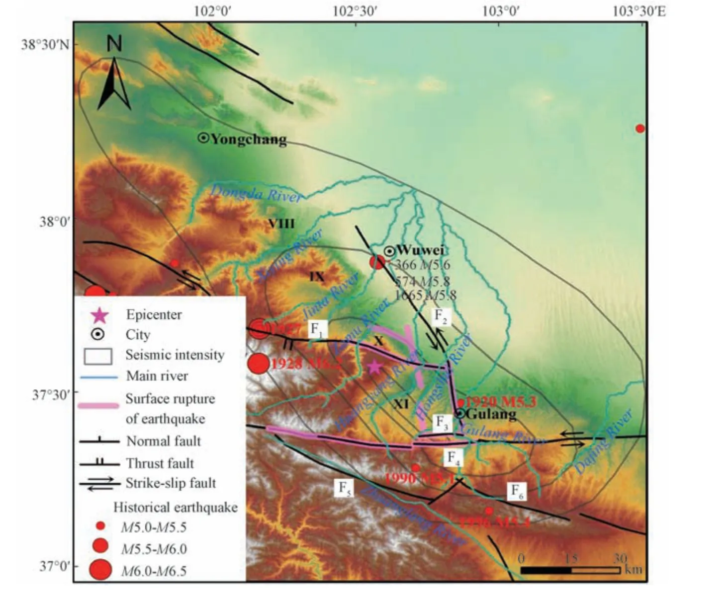
Figure 1 Regional tectonic setting of 1927 Gulang earthquake and location of the study area
There are several active faults with strong tectonic activity developed in the study area(Fig.1).Under the influence of regional NE-SW compressive tectonic stress,the main faults in N-W-W-trending or near E-W-trending in this area have thrust and left-lateral strike-slip activities,such as the Maomaoshan-Laohushan fault and the Tianqiaogou-Huangyangchuan fault.And the N-N-W-trending faults,such as the Wuwei-Tianzhu buried fault,have thrust and right-lateral strike-slip activities.Besides,the 1927 Gulang earthquake has formed several different directions and different scale of the surface ruptures in the surface(Fig.1),resulting in a variety of interpretations by different scholars(Zhou Guang,1954;Jia Yunhong,1982;Seismological Bureau of Xinjiang Uygur Autonomous Region,1988,Hou Kangming et al.,1998;Hou Kangming,1998;Liu Yu et al.,2006;Liu Baiyun et al.,2015;Gao Wei,2018;Shi Feng et al.,2019).Among them,whether the Tianqiaogou-Huangyangchuan fault is involved in the rupture is the most controversial.Correspondingly,opinions on the seismogenic faults of the Gulang earthquake remains equivocal for a long time.In detail,there are two main views on the seismogenic faults of the Gulang earthquake.Some studies consider(Zhou Guang,1954;Seismological Bureau of Xinjiang Uygur Autonomous Region,1988;Hou Kangming,1998)that the Huangcheng-Shuangta fault and the Wuwei-Tianzhu fault,which are dominated by thrust faults,are simultaneously thrusting toward the northeast and leading to the occurrence of the Gulang earthquake.The other interpretation(Zheng Wenjun et al.,2004)is that the Gulang area where the transitions and intersections of multiple fault structures intersect generates the Gulang thrust nappe due to the strain resolution.It includes the Tianqiaogou-Huangyangchuan fault,the Huangcheng-Shuangta fault and the Wuwei-Tianzhu hidden fault.It is the neotectonic movement of the Gulang nappe that may cause the 1927 GulangM8.0 earthquake with a trend of thrusting.While the latest studies(Gao Wei,2018;Shi Feng et al.,2019)consider the Tianqiaogou-Huangyangchuan fault as a fault zone with active tectonic movement,it is not involved in the surface rupture of the ancient wave earthquake in 1927 and is not one of the earthquake faults.Additionally,recent studies(Gao Wei,2018;Shi Feng et al.,2019)believe that the Tianqiaogou-Huangyangchuan fault is a fault zone with active tectonic movements,but there is no evidence that the fault has participated in the surface rupture of the 1927 Gulang earthquake and is not one of the seismogenic faults.
2 DATA AND METHODS
The Google Earth images have an excellent spatial coverage which reaches 100%,including multiple imaging periods,and are constantly updated,which can meet the requirements of landslide interpretation for satellite images.In this study,the topographic data in the landslide impact factor analysis are obtained from the ASTER GDEM V1 Digital Elevation Model(DEM)with a spatial resolution of 1 arc second in the Geospatial Data Cloud Website,which is processed as DEM data with 20 m resolution by using projection operation in ArcGIS software.The slope gradient,slope direction and river data in this paper are derived from this 20 m DEM data.Stratigraphic age data from the 1∶500 000 National Geological Map are published by the China Geological Survey.In addition,fault's information comes from the China Active Tectonic Map(Deng Qidong,2007).
The research methods include directly interpreting the landslide in the 3D view of Google Earth software,directly interpreting landslide by adding vector polygons and marking typical landslides for subsequent research.The study area is mainly hilly-gully landform with loess and sparse vegetation coverage,which is beneficial to the visual interpretation of seismic landslides.Deep seismic landslides,especially loess landslides,often show clear traces on the Google Earth platform,such as the Dengshanzhuang landslide(Fig.3).The main target of this interpretation work is the deep seismic landslides.These typically recorded landslides are interpreted on the Google Earth platform,and the standard of visual interpretation is formed according to their morphological characteristics and vegetation conditions.Because the landslides triggered by the same seismic event have little difference in the image,the rest seismic regions can be interpreted according to this interpretation standard.Although some landslides triggered by the Gulang earthquake are artificially transformed into terraced fields,the landslide back wall,landslide surface,and landslide deposits remain clear and easy to distinguish,ensuring the objectivity and accuracy of the landslide visual interpretation work.Historically,the frequency and intensity of earthquakes in the study area are not high.Except for theM8.0 Gulang earthquake in 1927,most of the historical earthquakes in the area have the magnitudes aroundM5.0,and noM7.0 or higher earthquake has been recorded.These small-magnitude earthquakes are less likely to trigger landslides in that anM5.0 earthquake can only generate about 1/1000 energy of anM7.0 earthquake.If co-seismic landslides are generated,their scale and number should not be too large,and as time goes on,landslides triggered by historical earthquakes can no longer be identified due to natural erosion or the artificial modification of the surface.Also,the study area located in northwestern China which is a region belongs to arid continental monsoon climate and has seldom continuous heavy rainfall,resulting in a small probability of landslide occurrence triggered by rainfalls.If any,the damage degree that the landslides may produce is tiny.Moreover,the rainfall landslides are small in scale and easy to restore their original appearance,which also lead to the difference in scale and shape between the rainfall landslides and the co-seismic landslides in 1927.After the completion of interpretation,the landslide files are imported into ArcGIS software for Topological Analysis and other repair operations,and then the Spatial Analysis function in ArcGIS software is used to statistically summarize landslide quantity,landslide area and grading area,for the purpose of obtaining the relationship between each impact factor and seismic landslides.
3 RESULTS AND ANALYSIS
3.1 Interpretation Results
Using the above standard for interpretation,a total of 1 516 landslides are interpreted,including about 600 glacial landslides suspected of resulting from melting ice and snow in the Lenglongling Snow Mountains and other snow mountains in the eastern branches of the Qilian Mountains outside the study area.It is not certain whether such landslides are caused by the 1927 Gulang earthquake,so these landslides are not involved.Finally,936 landslides are determined(Fig.2).For the statistics,the total landslide area is 58.6×10⁶m2,the minimum landslide area is 2 343 m2,the maximum landslide area is 1.08×10⁶m2,and the average landslide area is 62.6×10³m2.The area for each individual landslide is mainly small and medium-sized.Among them,there are 4 landslides with an area of more than 106m2,150 landslides with an area of 105m2-106m2,the largest number of 673 landslides are found in the area of 104m2-105m2,and 111 landslides with an area less than 104m2.
It can be seen from the landslide distribution map(Fig.2)and landslide density map(Fig.6)that seismic landslides are mainly distributed in two areas.One locates around Dengshanzhuang in the middle of the X degree area,and the other is situated in the vicinity of Xishanbao-Huangyangchuan in the south of the X degree area.The number of landslides in the two concentrated areas accounts for 49.6% of the total number of the interpreted landslides.The Dengshanzhuang landslide zone occurs in the loess hills in the southeast of New Dengshan Village,with a general trend of more than 10 km long in the N-W-W direction,and a total area of about 1.29×10⁶m2.One of the largest landslides generated by the earthquake is the Dengshanzhuang landslide,which is about 800 m wide and more than 400 m long.The back wall of the landslide reaches the top of the mountain and slides from the ridge to the direction of N-W-W,burying the entire old Dengshan village.Fig.3 shows the interpretation of the landslides in the Dengshanzhuang landslide zone(center point coordinates:102.733°E,37.534°N)(imaging time:2017-08-12).Each red area in the figure represents a landslide,with a total number of 25.
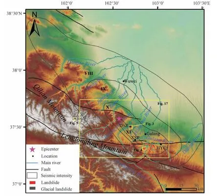
Figure 2 Distribution map of landslides triggered by the 1927 Gulang earthquake
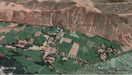
Figure 3 Interpretation of the Dengshanzhuang landslides zone
The Xisanpu-Huangyangchuan area has the largest distribution of landslides,including approximately a dozen landslide zones and more than 400 landslides.Fig.4 shows the interpretation of an area(center point coordinates:102.897°E,37.406°N)in the southeast of Xishanpu in the X degree area(imaging time:2019-08-18).Each red area in the figure represents a landslide.It can be seen that the shape of deep seismic landslides is complete and easy to distinguish.
Fig.5 shows the interpretation of glacial landslides in an area(center point coordinates 102.118°E,37.591°N)of the eastern branch of the Qilian Mountains in the west of the study area(imaging time:2018-09-07).Each red area in Fig.5 represents a landslide.
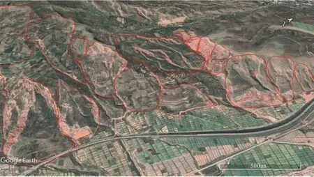
Figure 4 Interpretation of landslides in the south part of the X degree area

Figure 5 Interpretation of glacial landslides in the Qilian Mountains
3.2 Analysis of Distribution and Density of Landslides in the Gulang Earthquake
The study area(VIII-Ⅺintensity area)is 12 354 km2.The point density of landslides is 0.075 km-2and the area density of landslides is 0.47%.The point density of landslide distribution map for the Gulang earthquake(Fig.6)is made in ArcGIS software by setting the searching radius to 5 km,selecting kernel for the point density type and setting the grid resolution to 20 m.The maximum point density can reach 2.867 km-2.According to the classification of 0.1 km-2,0.1-0.2 km-2,0.2-0.5 km-2,0.5-1 km-2,1-2 km-2,2-2.867 km-2,we divide the point density of landslides into 6 categories.The occupied area with the landslide point density of 2-2.867 km-2is 66.82 km2,the 1-2 km-2occupied area is 158.34 km2,the 0.5-1 km-2occupied area is 236.13 km2,the 0.1-0.2 km-2occupied area is 639.61 km2,and the occupied areas with the landslide point density of 1-2 km-2,0.5-1 km-2,0.1-0.2 km-2,are 158.34 km2,236.13 km2,and 639.61 km2,respectively.The high-incidence area and high-density area of the landslides are located in the middle and south of the X intensity area,but not in the XI intensity area.The possible reason for this situation is that the concentrated distribution area of landslides has a variety of favorable conditions for landslides,such as the topography,geology and earthquake conditions.The concentrated areas of landslides in the X intensity area,such as the Xishanpu-Huangyangchuan area,are characterized by steep terrains,deep river cutting and weak rock strength.In XI degree area,IX degree area,VIII degree area and other areas of X degree area,although the seismic intensity conditions that trigger large-scale seismic landslides are available,the terrain and geological conditions in these areas may not be conducive to the occurrence of landslides,such as the gentle terrain,the strong rock strength,etc.
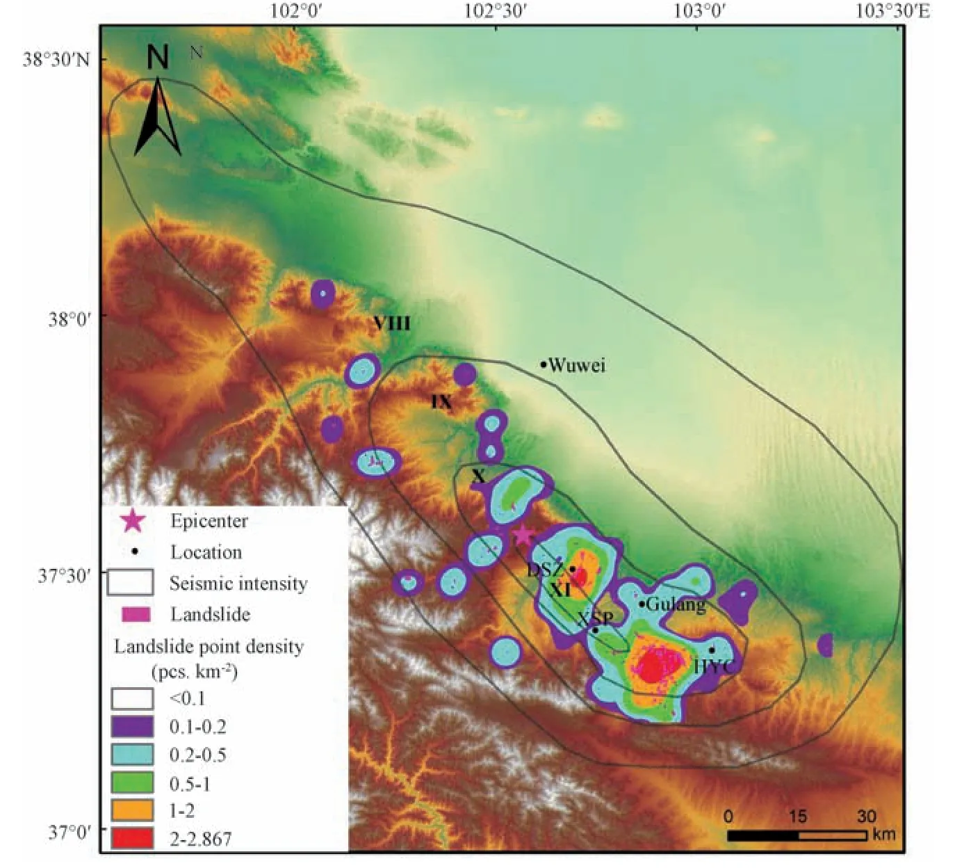
Figure 6 Point density map of seismic landslides triggered by Gulang earthquake in 1927
3.3 Analysis of Impact Factors of Seismic Landslides in Gulang Earthquake
The main factors influencing the occurrence of seismic landslides mainly include topography,geology and earthquake.In order to explore the relationship between seismic landslides and these impact factors,slope gradient,slope direction,distance from rivers,stratigraphic age,distance from the epicenter,seismic intensity and distance from faults,are selected to analyze the number and density of landslides in different impact factors.
The elevation range of the whole study area is 1 420-4 586 m and is divided into 5 sections which are 1 420-2 000 m,2 000-2 400 m,2 400-2 800 m,2 800-3 200 m,and>3 200 m.Fig.7 shows that the grading area decreases with the increase of elevation,and the maximum area is 5 041 km2within the range of 1 420-2 000 m.The number and density of landslides in these elevation sections generally show a tendency that they mainly concentrates in the central part.In the range of 1 420-2 000 m,the terrain is relatively gentle.Most of the areas are plains where landslide cannot occur.Therefore,only 12 landslides are triggered in that section.In addition,no landslide occurs in areas where elevation is over 3 200 m.The landslides concentrate in the section of 2 000-2 800 m(91.3%),among which the section of 2 400-2 800 m has the largest number of landslides(440)and the highest density of landslides(0.182 km-2)indicating that the elevation may influence the landslides triggered by the Gulang earthquake to some extent.
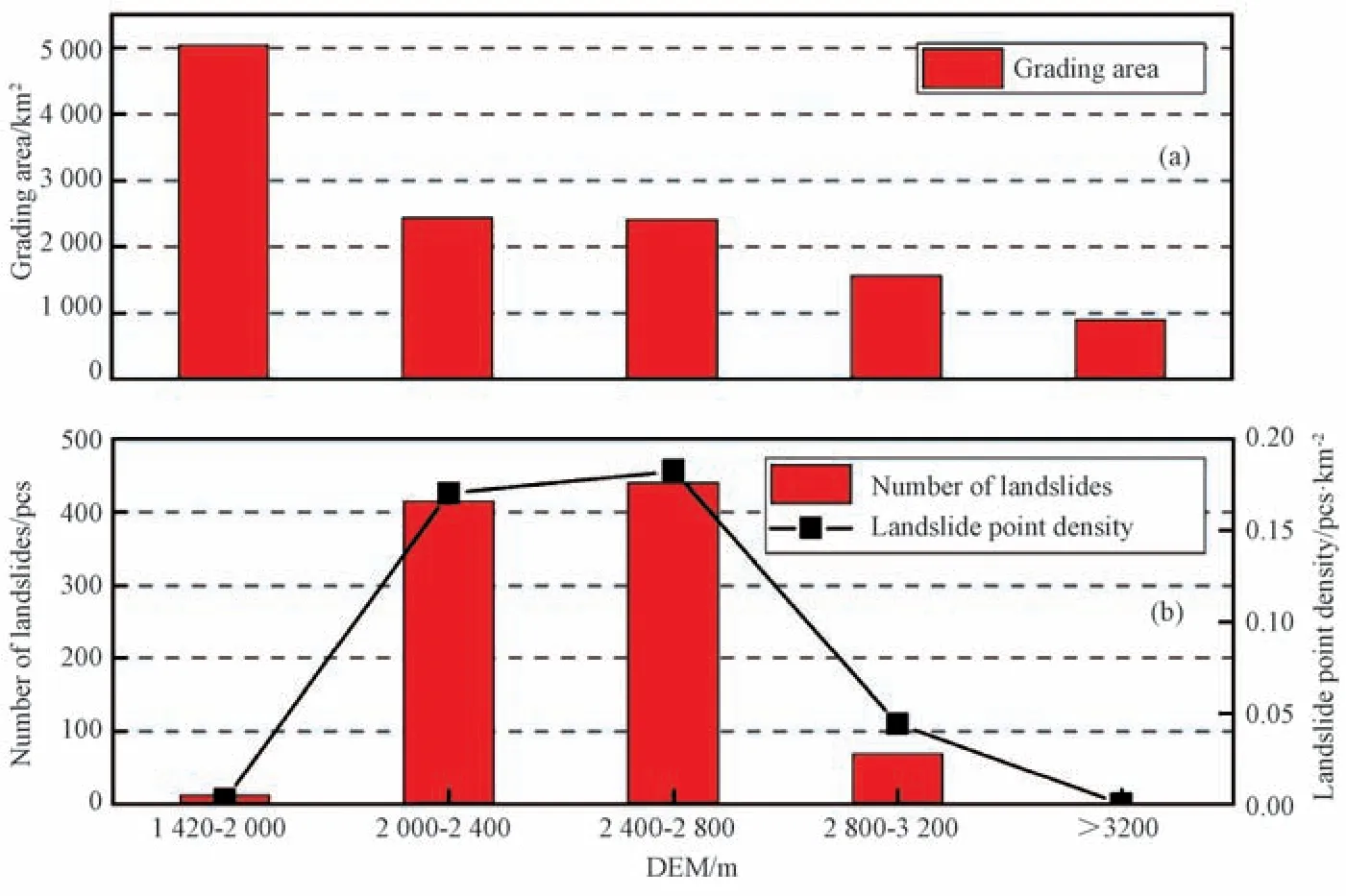
Figure 7 Gulang earthquake-triggered landslides versus elevation
The slope is one of the most important factors affecting the occurrence of seismic landslides,because the slope determines the effective free surface of the landslide.The slope gradient range of the study area is 0-75.8°.To investigate the relationship between seismic landslides and slope gradient,the study area is divided into 11 sections according to 0°-5°,5°-10°,10°-15°,15°-20°,20°-25°,25°-30°,30°-35°,35°-40°,40°-45°,45°-50°>50°.In principle,the grading area decreases with the increase of the slope gradient.The total area of the 0-25° slope gradient is 10 389.33 km2,accounting for 84.1% of the entire study area,indicating that the entire study area is dominated by gentle slopes.It can be seen in Fig.8 that the number of landslides generally shows a trend of less on both sides and more in the center.53.5% of the landslides occur in the 10°-30° slope section,among which the 15°-20° slope section has the largest number of landslides(137).The landslide density increases with the increase of the slope,the landslide density in the grade of slope greater than 30° is all more than 0.2 km-2.The landslide density is the highest in the section of>50°,reaching 0.66 km-2.This trend indicates that the slope gradient has a strong controlling effect on seismic landslides.
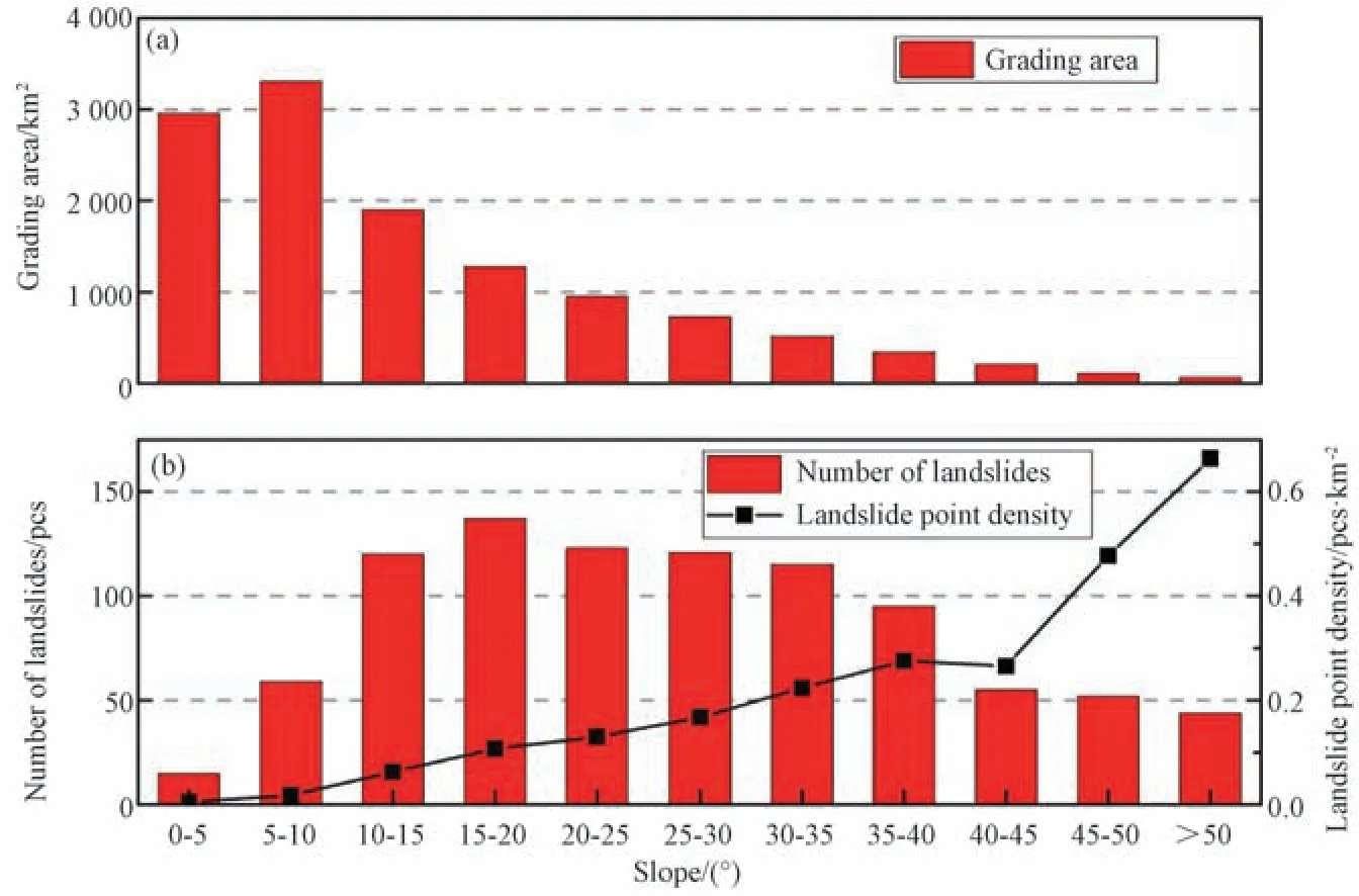
Figure 8 Gulang earthquake-triggered landslides versus slope angle
Slope direction is also a terrain impact factor of seismic landslides.Firstly,due to the different solar radiation intensity and precipitation intensity of each slope,there are differences in vegetation coverage and water evaporation on each slope surface,which affects the vulnerability of landslides.More importantly,the direction of the regional stress field,the sliding direction and mechanical properties of the faults,and the propagation direction of seismic waves make it more likely that the landslides may occur in several slope directions.The latter effect is more significant in seismic landslides.The statistical results of the landslides versus slope directions.Fig.9 show that the number and density of landslides in the east and west directions are slightly higher than those in other directions,so the dominant landslide direction of this earthquake is EW,which is consistent with the results of previous studies(Zou Jinchang et al.,1994b).The possible reason is that the earthquake is strongly affected by the nearly east-west faults.Besides,from the distribution map of the seismic landslides,it can be seen that a large number of landslides occur around the nearly EW Tianqiaogou-Huangyangchuan fault,which may have some relationships to the Gulang earthquake in 1927.From the statistical results of this study,the frequent and susceptible slope directions of the landslides are not particularly significant.The reasons may be as follows:(1)The seismogenic faults of the Gulang earthquake have not been clearly determined.There are multiple faults with different directions and different sliding properties in the study area.It is possible that one or a combination of several faults cause the earthquake.(2)The area dominated by a series of strike-slip active faults in NW direction under the maximum principal NE-SW compressive stress,and the propagation direction of the seismic wave is mainly NS.All these lead to a certain distribution of landslides in other slope directions.
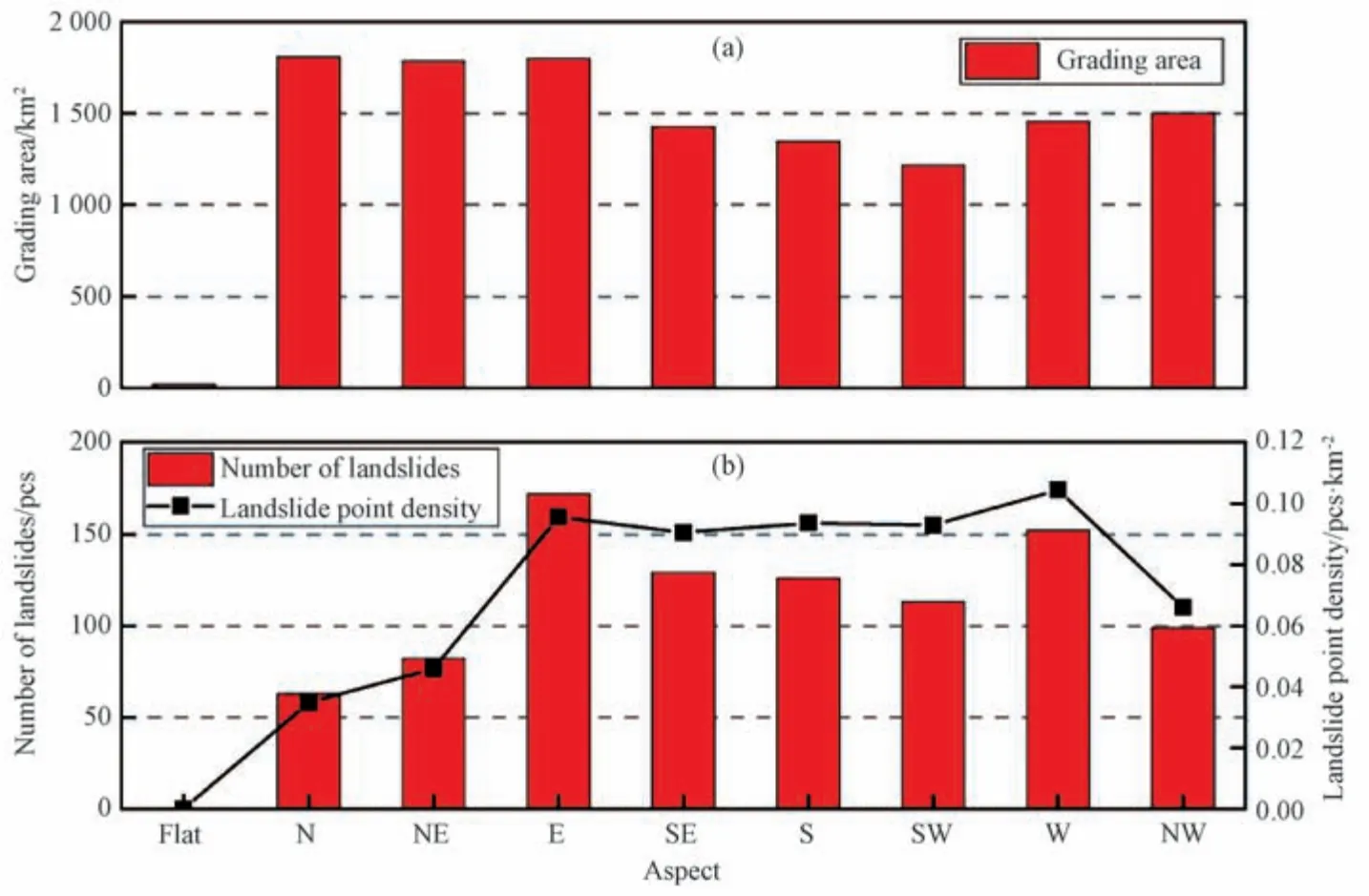
Figure 9 Gulang earthquake-triggered landslides versus slope aspect
After dividing the distance to rivers into 7 sections with an interval of 1 km,the relation between seismic landslides and rivers is calculated.It can be seen from Fig.10 that most landslides occur near the river,and 1 km from the river is a high-incidence and highdensity area of the landslide distribution.This is because the Lenglongling Snow Mountain is crowned with snow everlasting,and the melted snow water may provide the source of rivers and groundwater in the study area.The drainage system in the area is relatively developed,leading to deeper river valley topography and severely eroded valley landforms in the study area.As a result,the landslides on both sides of the river and river terraces are easily occurred,such as the Dengshanzhuang landslide zone which is within 1 km of the southeast bank of the Huangyang river,indicating that the abundant drainage system in the study area provides favorable conditions for the occurrence of landslides.
Strata is also an important factor affecting the occurrence of seismic landslides because it is a critical material condition for the occurrence of landslides.Landslide susceptibility in regions with different strata are often different.The stratigraphic age distribution of the study area(Fig.11)ranges from Cambrian(∈)to Quaternary(Q).It can be seen from Fig.12 that the Quaternary stratum covers an area of 6 616.35 km2,accounting for 53.6% of the entire study area,and 204 landslides have been developed,which is one of the highest incidence areas of landslides.The landslide mainly occur in the loess area of the Middle-Upper Pleistocene,and the thickness of the loess varies greatly,ranging from a few meters to 40 meters.The landslide body is mainly composed of loess sub-sandy soil,which is characterized by large voids and vertical joints.Besides,the soil is soft,which is conducive to groundwater infiltration.Since most areas covered by Quaternary strata are plains(74.6%)that cannot produce landslides,the density of landslide points is low.Calculating the density of landslide points after excluding the plain area,the actual density of landslide points in the Quaternary stratum is 0.146 km-2.The numbers and density of landslides developed in the Cretaceous stratum are higher than those in other strata.260 landslides have been developed in the Cretaceous stratum with an area of only 358.9 km2,indicating that the Cretaceous strata are high-prone areas for the Gulang earthquake.The red sandstone of the estuarine formation in the Cretaceous system is mostly the product of alluvial fan and river sedimentary system,which are unstable and covered by loess layers,giving rise to the easy formation of impervious layers at the contact between loess and red sandstone,thus,the main type of landslide in this area is mixed loess landslide with loess-red sandstone bilayer structure.
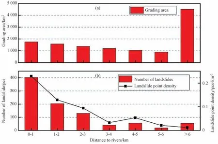
Figure 10 Gulang earthquake-triggered landslides versus distance from the flow
Furthermore,seismic intensity is also an important factor affecting the occurrence of seismic landslides.The intensity of the magistoseismic region of the Gulang earthquake is XI and the study area is the VIII-Ⅺdegree area.It can be seen from Fig.13 that the number of landslides in VIII-X degree areas increases with the increase of intensity.The number of landslides in the X-degree area is the highest(561),while the number of landslides in the XI-degree area is the least.This is because in the Loess Plateau,the loess has the highly seismic vulnerability,and a dense distribution area of landslides may occur when the seismic intensity reaches a certain level.The X intensity region reaches the seismic intensity conditions required for the large-scale landslides,and some areas are conducive to the topographic and geological conditions.However,the area of the XI-degree area is only 164.35 km2,the terrain in some areas is relatively gentle,and the slope is relatively slow,leading to an extremely adverse topographical condition for the occurrence of large scale landslides.This has led to the irrelevance between the number of landslides and the intensity.However,it can be seen that the landslide density increases with the increase of intensity,and the XI-degree area has the maximum landslide density(0.517 km-2).This also shows that the loess seismic landslide is closely related to the seismic intensity,but not completely consistent with the earthquake isoseismic line.Meanwhile,the seismic landslides are also strongly controlled by the terrain and geological conditions.
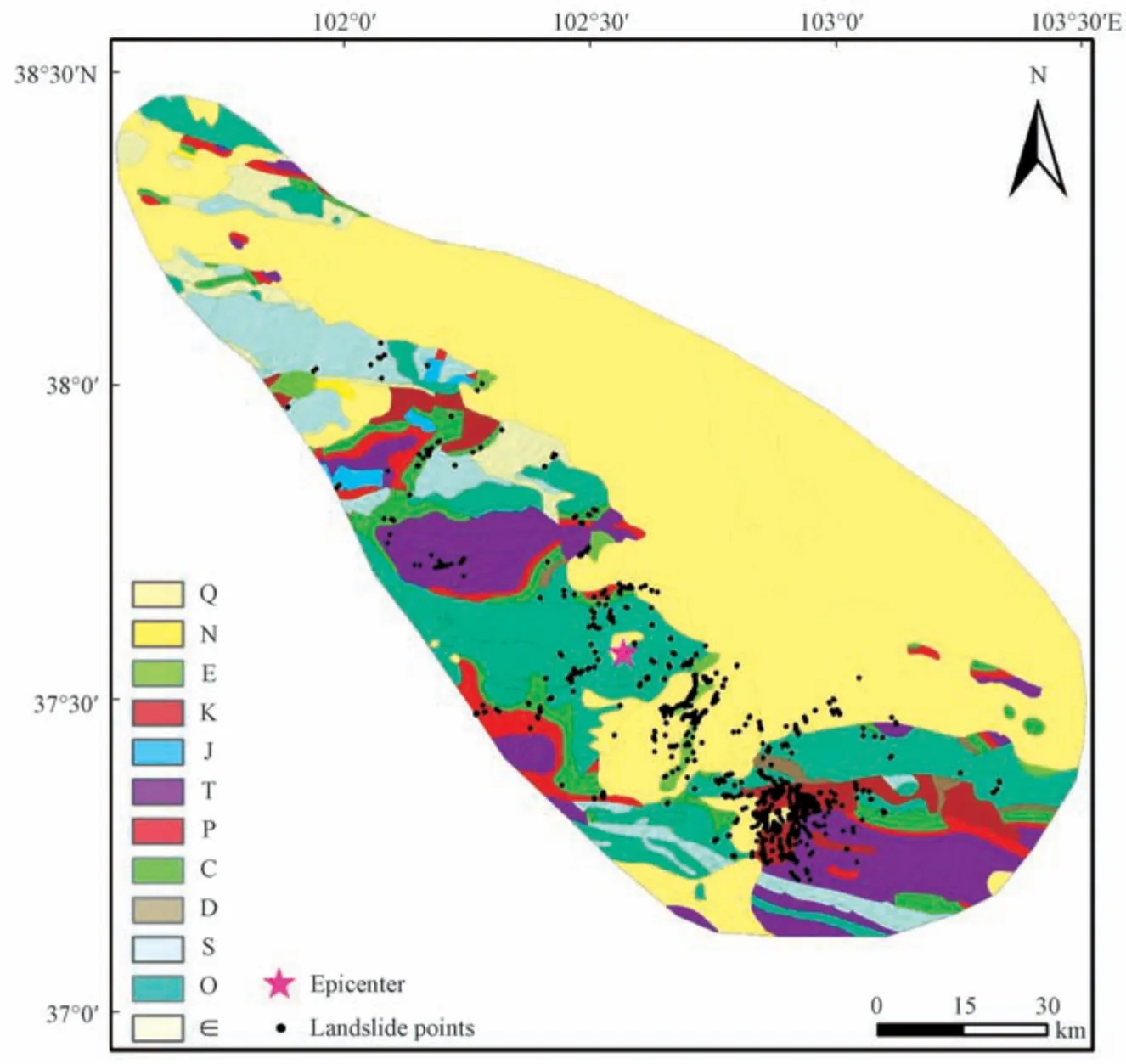
Figure 11 Distribution map of each strata age and landslides in the study area
The epicenter location of the Gulang earthquake determined by different studies is quite different.This paper uses the instrument epicenter location(37.6°N,102.6°E)given by the China Seismic Catalogue(Gu Gongxu et al.,1983).After dividing the distance to epicenter into 15 sections with an interval of 5km,the relation between seismic landslides and epicenter is calculated.The results are shown in Fig.14.Unlike most earthquakes,the Gulang seismic landslides are different that the distance to epicenter and landslide numbers not show a positive proportion.Therefore,only 4 landslides are generated within 5 km from the epicenter.The high-incidence and high-vulnerability areas of the landslide are located within a range of 35 to 45km from the epicenter.A large number of landslides(40.5%)have been triggered in this area,and the landslide density has reached the highest value.It is because the concentrated landslide areas in the south of the X intensity circle are within this range.This shows that the Gulang earthquake-triggered landslides have little relationship with the distance from the epicenter.
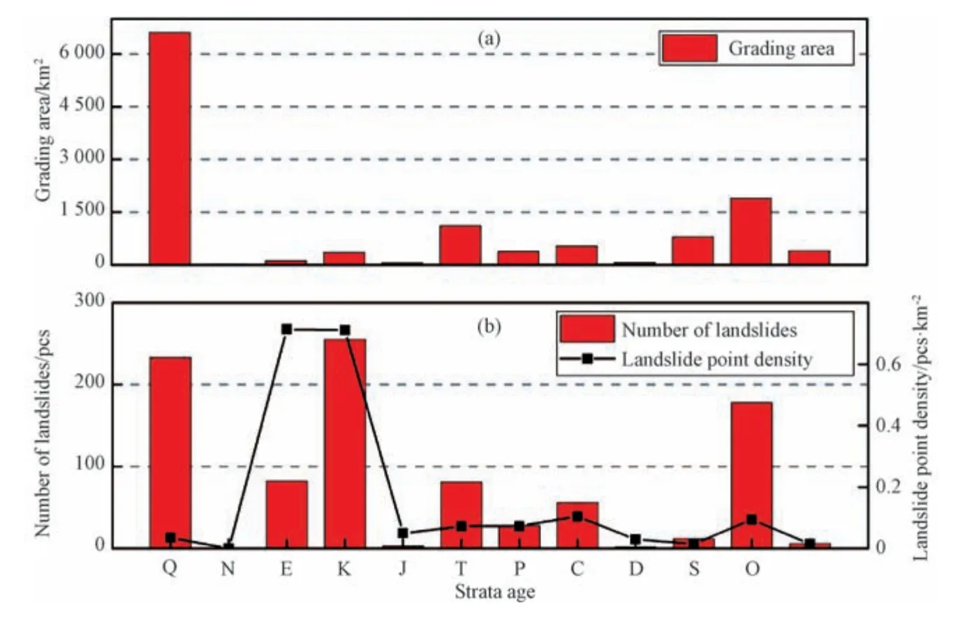
Figure 12 Gulang earthquake-triggered landslides versus strata
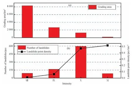
Figure 13 Gulang earthquake-triggered landslides versus seismic intensity
Previous studies(Zou Jinchang et al.,1994a),indicate that the seismic landslide is obviously controlled by the faults.Since it is not clear which fault participate in the seismic activity in this earthquake,the statistics are the relationship between the landslides and the distance of all six faults in the study area.The study area is divided into 7 sections according to the distance to the faults:0-2 km,2-4 km,4-6 km,6-8 km,8-10 km,10-12 km,and>12 km.The results are shown in Fig.15.The number and density of landslides increase with the reduction of the distance to faults.The number and density of landslides are the largest within 2 km from the faults.It is proved that the Gulang seismic landslides have a close relation to the faults.In addition,68 landslides are 12 km away from the faults,58 of which are within 2 km from the rivers,which also shows that the seismic landslides are controlled by multiple factors at the same time.
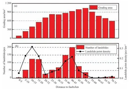
Figure 14 Gulang earthquake-triggered landslides versus distance from the epicenter
From the relationship between seismic landslides and faults,we can simply infer which fault has tectonic activities in the earthquake.The landslides occurring within 2 km from the fracture zones are assumed to be caused by the activities of the fracture zones.Statistical analysis of the relationship between landslides within 2 km from faults and each fault in Fig.16 shows that the maximum number of landslides occurs within 2 km from the Tianqiaogou-Huangyangchuan fault(109),Xishanpu-Dieluoya fault has the highest density of landslides(0.78 km-2).The possible reason is that the landslides,collapses and other disasters directly caused by the fracture zones activity during the earthquake,or it may be that the geomorphology of the fracture structure provides favorable terrain conditions for the occurrence of landslides.The eastern part of the Tianqiaogou-Huangyangchuan fault happens to be a dense landslide area,which indicates that the Tianqiaogou-Huangyangchuan fault may participate in the 1927 Gulang earthquake tectonic activity.

Figure 15 Gulang earthquake-triggered landslides versus distance from faults
4 DISCUSSION
A detailed and complete catalog map of seismic landslides plays a decisive role in the quantitative analysis of seismic landslides hazards(Harp E.L.et al.,2011;Xu Chong et al.,2013).In this study,some qualitative and quantitative comparisons are made based on previously published papers about the distribution regularities of seismic landslides in the Gulang earthquake.The statistical results of incomplete and perfect landslides distribution maps are quite different.In this study,936 landslides triggered by Gulang earthquake are obtained,far more than the previous ones.With the increasingly collected results of landslide distribution,some new phenomena and information are obtained.
(1)Regarding the interpretation results,in the study of Zou Jinchang et al.(1994b)and Chen Yongming et al.(1999)which mention the distribution regularities of landslides,the mainly mentioned landslides zones include:the Ta'erzhuang north landslides zone;the Dongqingding-Wangjiazhuang landslides zone;the Dengshanzhuang landslides zone;the Xishanpu southeast landslides zone,the Daquantan-Huangyangchuan landslides zone;and the Dagouxipo landslides zone and the Shangsi bedrock landslides zone.Previous studies describe the landslide distribution in a qualitative way,and only mark the approximate location in the distribution map(Fig.17)without quantitative analysis,lacking the the specific number,area and location of the landslide.The interpretation of these landslide zones can be seen from Fig.17.Except for the Dongqingding-Wangjiazhuang landslide zone,other mentioned major landslide zones have all been found and interpreted in the Google Earth platform.In addition,the landslide distribution obtained in this paper has the information of accurate location,boundary and area,and a large number of previously undiscovered landslides have been found and identified.Then the first detailed map of landslide distribution on the area of the Gulang earthquake in 1927 is formed.It can be seen that the results of this interpretation are more interpreted than previous ones,and can show the distribution of Gulang seismic landslides more intuitively.
(2)Regarding the distribution rule of landslides,this paper divides the study area into the east(48.1%)and west(51.9%)parts with Gulang County as the boundary.The number of landslides which generated in the east and west of Gulang is not much different.Due to the existence of the Tianqiaogou-Huangyangchuan fault and the Gulang river in the area east of Gulang,prolonged running water erosion and complex tectonic background have led to the fragmented landform characteristics of Huangyangchuan area.And under the action of strong vibration,there are numerous landslides along the river and fault zone.To the west of Gulang is the location of the intense earthquake area.The water system is more developed,and it is also the main area of the loess hills.The thickness of the loess is larger,up to 45m(Zou Jinchang et al.,1994b).These collectively cause the west of Gulang become a frequent and prone area for landslides.Zou Jinchang et al.(1994b)argue that the west of Gulang is the concentrated distribution area of landslides.This may be because the investigation of the landslide distribution in the previous period has a low spatial coverage,and the missing areas locates to the east of Gulang,leading to the deviation of the landslide distribution regularities.
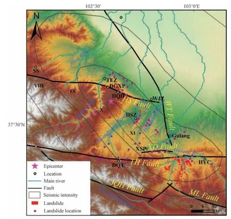
Figure 17 Comparison map of the distribution of landslides(Landslide location changed from(Zou Jinchang et al.,1994b))
The results of this study indicate that the landslides are mainly small and mediumsized,and they are unevenly distributed in the study area.Some of the landslides are distributed along the river and the fault zone in stripes.The other part is densely arranged along the valley,concentrated in the middle and south of the X intensity zone.The foremost reason for the landslides dense area is the favorable terrain conditions for landslide development.The existence of near E-W and N-E-E fault zones generate the deep cuts of valley along the fault zone,steep terrain,unstable soil mass,and the exposure of groundwater and spring water along the fault zone,as well as the cutting and erosion of rivers;Secondly,the fragile geological conditions of the area are composed of the Quaternary Middle-Upper Pleistocene loess and the Cretaceous sandstone covered with loess.Under the combined action of the above topographic and geological conditions,the intense activity of faults,and the strong vibration of X degree,a large number of loess landslides and loess-sandstone mixed landslides are generated,thus,the area becomes a dense and prone area for the Gulang earthquake landslide,and it is still a dangerous area for landslides and collapse in the future.
(3)Due to the constraints of the era at that time,it was impossible to conduct a professional inspection in the site of Gulang earthquake,resulting in less and incomplete historical records.Furthermore,the intensity area was artificially delineated according to the disaster situation many years later,which caused great difficulties to the evaluation of the intensity area.Besides,there were many versions of epicenter positions determined by different seismic stations at that time,causing some deviations between the existing epicentral location and the actual situation.The statistical results of seismic factors in this study show the number of landslides may not conform to the traditional regularities that the number increases with the rise of intensity and the decrease of the distance to the epicenter;moreover,the high-frequency and high-density areas of landslides are located in the middle and south of the X intensity area,not in the intense earthquake area possibly due to the deviations in the location of the epicenter and the range of the intensity area.Therefore,it is necessary to use different methods to correct the location of the seismic intensity area and the epicenter.To some extent,the distribution of coseismic landslides can reflect the damage of the earthquake,and the distribution of landslides can be used to modify the location of the epicenter and the intensity area.
5 CONCLUSIONS
The Gulang great earthquake in 1927 have caused tens of thousands of casualties and have destroyed a large number of buildings,causing great loss to people's life and property.However,a comprehensive study on the landslide triggered by this earthquake is rare.In this paper,the systematic remote sensing interpretation of the coseismic landslides in the area VIII-XI of the Gulang earthquake is conducted,and the following conclusions are obtained:
(1)Based on the topographic fluctuations and remote sensing images of the Google Earth platform,this paper uses the visual interpretation method,taking the Gulang earthquake VIII-Ⅺ intensity region in 1927 as the study area(covering an area of 12 354 km2),and interpreting to obtain 936 seismic landslides.Two coseismic landslide high-density areas are obtained.Located in the Dengshanzhuang area in the middle of the X-intensity area and the Xishanpu-Huangyangchuan area in the X-intensity area,respectively.The total area of the interpreted landslide is 58.6 km2.The landslide point density and area density in the study area is 0.075 km-2and 0.47%,respectively.
(2)Statistical results of landslides versus impact factors show that the Gulang seismic landslides are controlled by multiple impact factors at the same time.The spatial distribution of the Gulang earthquake-triggered landslides is mainly related to factors such as elevation,slope gradient,slope direction,strata,seismic intensity,faults and rivers,and has little correlation with the distance from the epicenter.The elevation of 2 000-2 800 m is the high-incidence and high-vulnerability interval of the landslides.Substantial landslides occur within the range of 10°-30° slope,and the landslide density increases significantly with the increase of slope gradient.The number and density of landslides in the east and west are slightly higher than those in other directions.Most landslides occur along both sides of the rivers and the results show a positive relationship between the landslide quantity and the distance to rivers.The areas with Cretaceous and Quaternary strata are the main areas of the Gulang seismic landslides,the main type of landslide in this area is loess landslide and mixed loess landslide with loess-red sandstone bilayer structure.Landslide number in the X degree area is the highest.Seismic landslides are obviously affected by the faults,the closer to the faults,the greater the number and density of landslides.
(3)In the process of studying the Gulang earthquake in 1927,there is still no final conclusion about the seismogenic fracture of this earthquake,and there is a certain deviation in the distribution of intensity areas.It is an effective research method to study these unsolved problems by using seismic landslides,and is also the main content and research work that needs to be strengthened and combined in the future work.We suggest that the follow-up studies should focus on this aspect.
ACKNOWLEDGMENT
The authors show their sincerely thanks to the suggestions from LI Kai and HUANG Yuandong from China University of Geosciences(Beijing)and ZHANG Pengfei,MA Siyuan,SHAO Xiaoyi and TIAN Yingying from the Institute of Geology,China Earthquake Administration.
 Earthquake Research Advances2020年1期
- Earthquake Research Advances的其它文章
- The Spatial Distribution and Attribute Parameter Statistics of Landslides Triggered by the May 12th,2008, MW7.9 Wenchuan Earthquake
- Distribution of Landslides in Baoshan City,Yunnan Province,China1
- Hazard Assessment of Co-seismic Landslides Based on Information Value Method:A Case in 2018 MW6.6 Hokkaido Earthquake,Japan
- Discrete Element Modeling of Tangjiagou Two-Branch Rock Avalanche Triggered by the 2013 Lushan MW 6.6 Earthquake,China
- A Discrete Element Analysis of the Sliding Friction Heat in High-Speed and Long-Runout Landslides
- A Statistical Estimation Model for the Impact Force of Dry Granular Flow Against Rigid Barrier1
