风景园林与绿色基础设施在城市流域水资源规划中的重要作用
著:(美)罗伯特·瑞恩 译:于冰沁
城市流域面临着土地利用方式快速变化的挑战,这些变化威胁着快速增长的人口所需的水资源供应环节,迫切地需要气候适应型城市,以应对洪水增加、干旱期延长等气候变化。绿色基础设施是一种积极应对土地利用变化的方法,即在大尺度上保护自然资源,同时也在小尺度中发展创新方法,保护生态系统服务与功能。美国的城市流域中,许多土地利用变化的诱因是郊区住宅区的开发,导致了自然植被和农田大量被草坪所代替。这些变化往往是城镇规划的决策或业主个人共同导致的。然而,个人决定如何能影响更大尺度的城市流域呢?影响业主改造庭园等住宅景观的绿色基础设施的因素有哪些?对于这些问题我们知之甚少。
因此,本文作者通过美国马萨诸塞州波士顿以北的伊普斯维奇河(Ipswich River)流域的案例研究,探究如何在多尺度上利用绿色基础设施进行流域规划。由于雨水径流受污染、社区用水过度,伊普斯维奇河被认为是美国最受威胁的河流之一[1]。当地政府机构面临着频繁缺水、水质污染等问题,因此水资源保护和雨水管理是流域规划的当务之急。本研究包括为跨越市政边界的整个流域制定绿色基础设施规划方案,以及调查公众对住宅区绿色基础设施改造的接受程度。其中,住宅区的绿色基础设施包括雨水花园和耐旱景观等。本研究将为其他同样面临水资源问题的城市流域规划提供宝贵经验。
1 研究背景
伊普斯维奇河流域面积约为400 km2,人口16万人[2],横跨15个城镇的部分区域[3]i;然而,伊普斯维奇河为35万左右人口提供饮用水,其中大多数人生活在流域外。过度用水导致过去几十年里出现了严重的枯水事件。此外,郊区住宅不透水表面覆盖与草坪面积的增加也对水质和水量产生了负面影响。流域内的地表覆盖方式主要是林地(70%)。此外,除伊普斯维奇河及其支流外,还有77个池塘和湖泊[3]2-4。该流域位于波士顿都市区的东北边缘,都市区人口为470万人(2014年美国人口普查估算),预计会继续增加。流域上游为发展成熟的郊区,住宅密度中等,下游为有大量土地保护区的小城镇(图1)。

1 伊普斯维奇河流域的区位图与现有土地利用情况Location map and existing land use—Ipswich River Watershed

2 伊普斯维奇河流域的多尺度规划方案Multi-scalar approach to watershed planning—Ipswich River Watershed
为解决河水流量过低的问题,当地城镇对住宅户外用水采取了自愿和强制性措施,例如限制居民浇灌花园及草坪的天数。由州和联邦环境属资助的绿色基础设施示范项目已在伊普斯维奇河流域开展,以便展示创新的风景园林解决途径,如使用本地植物和利用雨水花园蓄留雨水径流,促进地下水渗透。研究表明,这些举措可以有效改善水质和补充地下水,但需要大规模应用才能对整个流域产生改变的作用[4]。
当地水资源保护的另一个重要参与者是伊普斯维奇河流域协会,一个促进流域保护意识、教育和宣传的非政府组织[2]1。该协会致力于将当地居民与河流连接起来,并游说政府为了人民和生态环境保护制定维持水平衡的政策。该协会实施了一系列的项目,致力于增进居民对河流的了解,并收集有关当地水环境和生物多样性的重要信息。
2 风景园林设计工作室
本研究项目由罗伯特·瑞恩教授领导的马萨诸塞大学安姆斯特分校的研究生风景园林设计工作室参与完成。该工作室与当地政府和伊普斯维奇河流域协会合作,致力于发展绿色基础设施计划,目的是保护该地区的水资源造福子孙后代[5]。工作室运用多尺度途径,使学生理解小尺度场地设计的力量是如何影响大尺度城镇和社区尺度的规划决策的。本项目运用地理信息系统(GIS)来识别重要的环境特征,包括含水层补给区、休闲游憩特征(如现状或规划中的路径和保护用地)、历史文化特征。本项目的景观评价阶段则利用了Fabos[6]、Benedict和McMahon[7]提出的绿道与绿色基础设施方法。
采用嵌套式的方法从多个尺度处理水资源问题。首先,在区域尺度,分析包含伊普斯维奇河在内的波士顿北岸都市区流域重要的水文联系,如流向附近城镇、现状或规划中的区域路径和开放空间系统的流域间水系流动。然后,进行流域尺度的分析,即跨越多个行政管辖区,从整体上寻找生态(自然)和文化模式之间的联系。结果显示,根据河流的位置或河段的不同,该流域有3种不同的土地利用模式和特征。流域的上游地区多为发展成熟、密度中等的郊区;中部地区正在城市化,拥有较多低密度的大面积住宅;而河口则有大片的保护用地围绕着历史悠久的伊普斯维奇(Ipswich)和埃塞克斯(Essex)镇中心。

3 伊普斯维奇河流域的绿色基础设施规划Ipswich River Watershed green infrastructure plan

4 托普斯菲尔德的重点区域Topsfield focus area
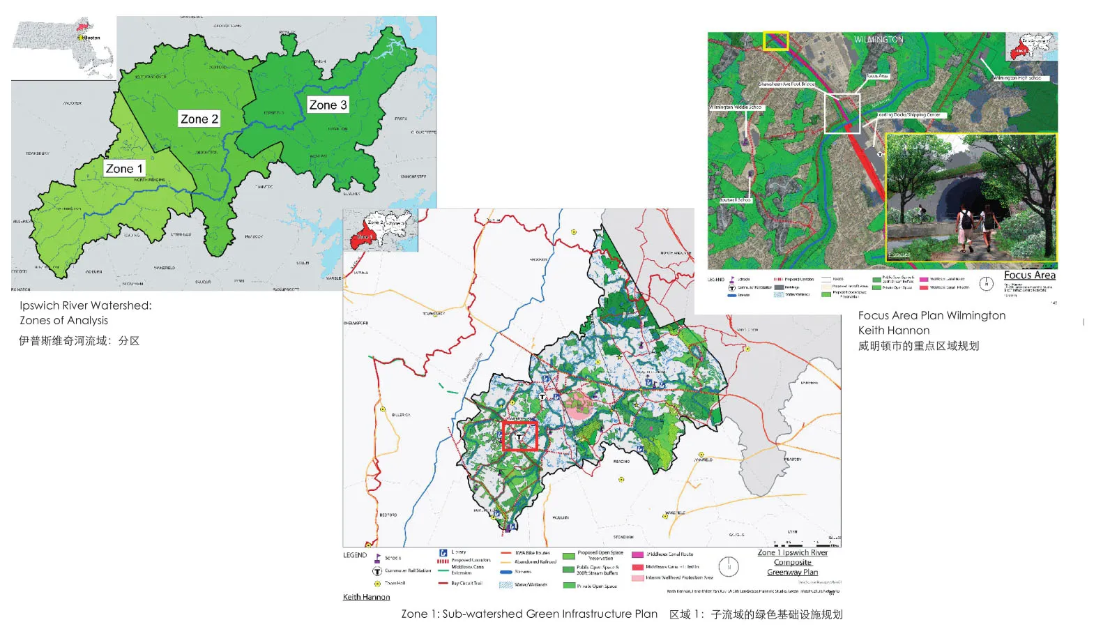
在经过初步的区域和流域尺度整体分析后,将9名研究生组成的工作室分为3个小组,分别研究3个子流域。子流域层面的详细分析有助于确定社区尺度的整体规划和场地设计应关注的重点区域,这有助于更大尺度规划的实施。虽然这种分析、规划和设计是由大到小尺度分级进行的,但这个过程并不是严格的线性过程,而是循环的、相互作用的、不断进行反馈的。例如,当发现了新的细节和新的关联时,会整合子流域规划,以修改最初的流域尺度的规划。这种迭代性质是多尺度流域规划的一个重要特点(图2)。
对水资源的景观评价表明,流域上游的开发导致含水层补给区和水源保护区出现了大量的不透水覆盖面,但这种现象在下游地区较少。此外,笔者研究伙伴[8]的一项独立研究发现,流域内不同城镇的不透水地表的面积也大小不等。例如,靠近河口的伊普斯维奇和埃塞克斯镇的不透水地表面积约为5%,而位于上游的威尔明顿(Wilmington)和雷丁(Reading)则高达20%。此外,伊普斯维奇和埃塞克斯镇中居住区的草坪覆盖面积约为6%~8%,而威尔明顿和雷丁的草坪覆盖面积则分别是13%和16%。这些不透水表面的油、重金属、盐和草坪中肥料等非点源污染恶化了流域的水质。
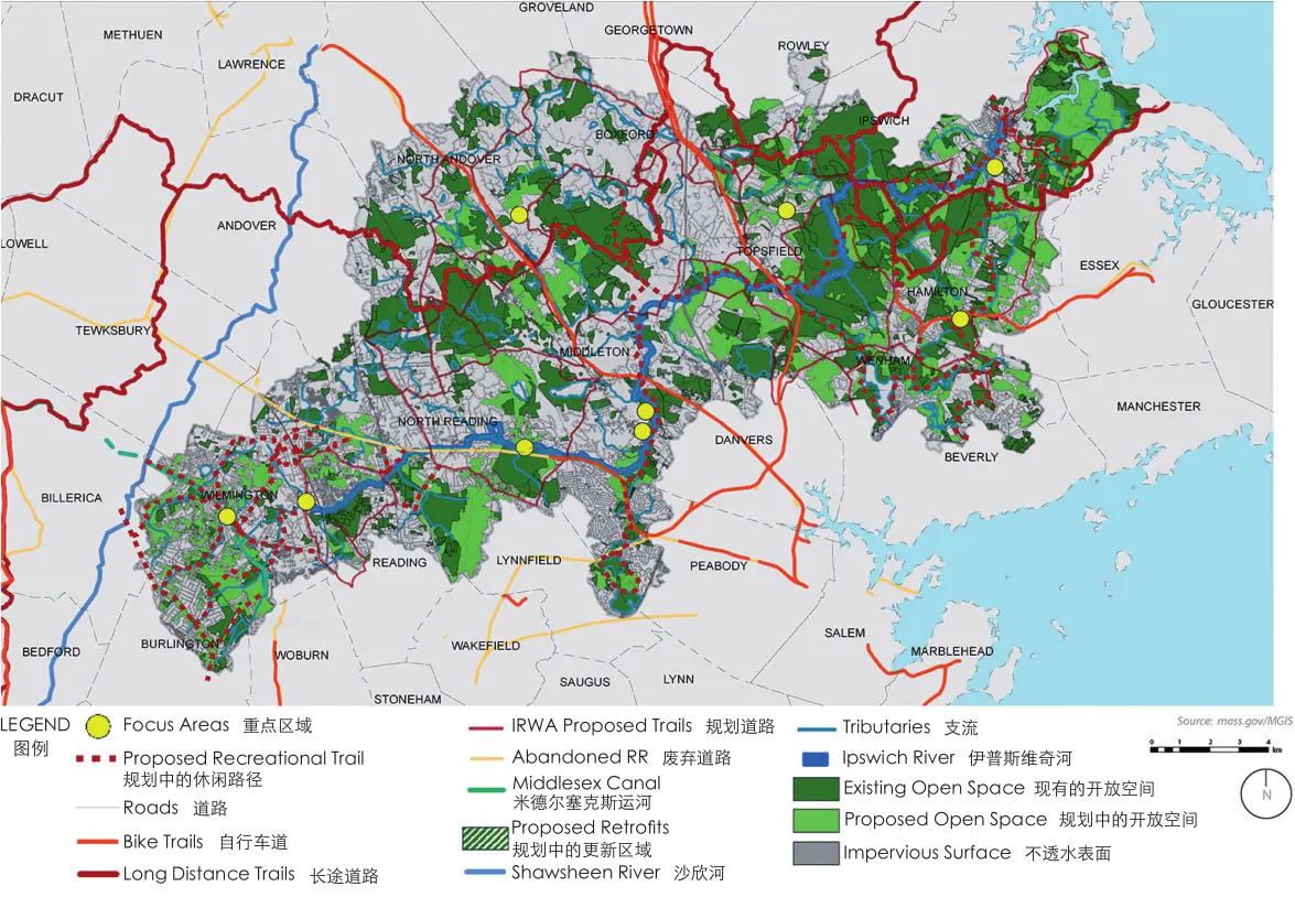
根据项目第一阶段的景观评价的结果,研究者制定了绿色基础设施规划(图3)。规划提出要保护水源地等流域开放空间,以便在伊普斯维奇河及其支流沿岸建立一个相互联系的绿地网络。其目的是保护含水层补给区和水源保护区。此外,规划还提出加强休闲道路的连接性,以便把当地居民与开放空间网络、历史文化资源联系起来。由于评估发现流域上游等诸多水资源区正在经历快速的发展过程,该规划建议对现有社区进行景观更新,以增加雨水的管理措施,促进雨水渗透,并用本土植物代替大面积草坪,以丰富生物多样性和栖息地。
3 社区重点关注的领域:改善生态环境健康
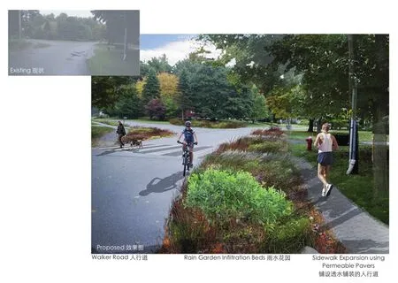
社区尺度的研究与实践重点关注流域范围内面临典型关键问题的区域,并通过创造性的风景园林设计方案来解决问题。本研究介绍两个具有上述特征的案例。其中一个研究和实践项目由研究生萨曼莎·安德森(Samantha Anderson)完成,重点关注托普斯菲尔德(Topsfield)小镇中的一个社区。该社区建在现有的含水层补给区上(图4)。为了应对这一挑战,该项目建议沿现有街道设置雨水花园,以收集道路上的雨水径流,并在雨水渗入地下水和含水层之前进行过滤与净化。这些雨水花园种植了本地的多年生草本植物。为了提高区域道路网络中韧性系统的连通性,在人行道的区域铺设透水铺装(图5)。对于平行于伊普斯维奇河支流的道路,采用植草沟、渗透池等,在道路径流汇入河流前进行收集与处理(图6)。
另一个由研究生邓恩·玉(Ngoc Doan)开展的项目在邻近河流的伊普斯维奇镇进行社区微更新。设计方案将笔直的道路变得弯曲,并在弯道上添加雨水花园和植物种植池,以取代6%的不透水表面(如人行道等,图7、8)。早期研究发现[9]63,当地居民对于在庭园中安装绿色基础设施的成本问题存在顾虑。因此,该项目使用成本计算器①预估移除草坪并替换为雨水花园的成本。该设计方案还提议移除该社区64%的草坪,取而代之的是本土植物和菜园等生产性景观。草坪移除的比例是基于一项研究成果确定的。该研究表明,如果雨水花园的设计符合文化取向并具有较好的视觉效果[9]66,那么当地居民和其他地方的业主可能会愿意用本土植物和雨水花园取代多达一半的草坪[10-11]。此外,为了提高人们对流域水环境问题的认识,该设计方案提议在重要区域安装教育标识来宣传雨水花园,解释其对生物多样性和水质的影响(图9)。
4 住宅景观偏好与绿色基础设施

5 为托普斯菲尔德城镇规划的雨水花园Topsfield — proposed rain garden

6 托普斯菲尔德小镇新型草地与街道效果图Topsfield — new native meadow and street section
除风景园林设计工作室外,本文作者与同事(包括副教授安妮塔·米尔曼和艾莉森·罗伊等)参与了一项由联邦政府资助的伊普斯维奇河流域研究项目。该研究的目的是调查影响居住区水资源保护和管理的因素。其中一个子项目是调查流域内居民对水资源管理的态度,尤其是参与绿色基础设施景观改造(例如用雨水花园代替现有草坪)的意愿[9]46。其中几项措施是在工作室的规划设计项目中提出的,并且已经在流域内开展实施,成为环境机构资助的示范项目的一部分。通过对225位业主的调查,发现业主了解并支持水资源保护与管理的规定。业主关心绿色基础设施方案(如雨水花园)的视觉效果,他们更喜欢整齐、简单、装饰性强的方案,而非复杂方案。由此表明,他们认同的是风景园林设计研究员琼·纳赛尔(Joan Nassauer)所说的“情景认知与细节关怀”的理论[10]167。业主们也关注雨水花园的安装和维护成本与传统草坪相比是否有优势。当地流域协会在保护河流方面发挥了重要作用——协会成员比普通公众更支持这些创新的风景园林方案。此外,政府资助的雨水花园示范项目是一种值得推广的模式,因为如果政府补贴能抵消一部分安装成本,居民更愿意安装雨水花园。因此,从多个尺度制定公共政策是十分重要和必要的。流域尺度的规划项目对局部区域和场地也能产生影响,鼓励居民在社区的建设与微观更新过程中模仿这种创新性的景观。
5 对风景园林师和水资源规划的启发
本项目为那些致力于流域水资源规划的风景园林师提供了一些可以参考的经验。
1)本项目说明了多尺度制定规划的重要性。因为流域通常会被划分为多个政治管辖区,例如伊普斯维奇河流域被划分为15个城镇辖区,每个城镇都拥有对土地使用的规划决策权,因此需要采用嵌套式的方法。而在较小尺度上进行分析时,则能发现大尺度中难以察觉和处理的新问题。例如考虑到行政管辖范围和私人土地所有权的重叠问题,地面覆盖面硬化问题只有在更小尺度的细节方案中才易于被识别与改善。
2)研究与实践发现水资源会受到前期开发的影响,这在城市流域发展中是常见现象。因此,需要风景园林师为社区的更新与改造提出适合的解决方案,以改善城市雨水的管理,增加蓄水层的渗透性,有效补充地下水,以及为附近的河流和溪流的供水。本项目的实施成为伊普斯维奇河流域郊区社区开发的示范性改造工程。风景园林师需要根据一个地区的城市化程度来有针对性地制定绿色基础设施的解决方案[12]。在城市化程度较高的地区,设计师需要考虑雨水花园等绿色基础设施的安装空间有限的问题。因此,在城市环境中,在人行道上沿着行道树铺设多孔的可渗透铺装及生态植草沟等方法比采用大型雨水湿地更合适。在流域中欠发达的地区,在开发前应考虑预先的保护措施,如设置防护性的河岸缓冲区、雨水湿地等,这种方法与工程建设相比,能低成本地提升流域的水质和水量[7]67。
3)本项目展示了如何将研究融入风景园林的教育和实践中。这种交叉学科的理论与设计实践参见纳赛尔和奥普丹(Opdam)关于结合科学研究与设计的开创性理论成果[13]642。无论是实证的研究项目,还是风景园林设计工作室,每一种途径都为解决城市流域所面临的挑战提供了不同的经验和启发。工作室的实践项目展现了场地设计的重要性,场地设计方案使抽象的区域流域规划更切实和具体,也可以使当地居民、政府决策者和非政府组织有机会看到、评价并反馈创新性的风景园林方案。本研究亦表明,了解当地居民对设计师提出不同类型的绿色基础设施技术的偏好至关重要,特别是对于那些主要由私人土地所有者做决策的景观基质,这一点尤为重要。此外,本研究和既往的研究发现,风景园林师和工程师等专家的态度偏好可能与居民的偏好截然不同。如果设计师事先没有考虑到这种偏好的差异性,那么很可能会阻碍绿色基础设施的有效实施,因此需要通过充分的调查研究来发现这些差异[9,14]。这类研究能帮助我们发现那些受居民欢迎的、生态友好的绿色基础设施解决方案。但这并不是忽视设计师的决策能力。设计师基于因地制宜的调查研究提出的设计方案仍发挥着关键作用[13]636。
4)本研究展现了流域协会等非政府组织在城市河流治理中发挥的重要作用。从很多方面来看,这些协会都充当了当地居民和政府决策者之间的桥梁。此外,本研究发现这些组织在流域教育、河流清理和环境监测的管理保护方面都发挥着至关重要的作用。
在城市人口增长的过程中,风景园林师有能力也有远见成为保护水资源的重要参与者。设计师通过多资源、多尺度的规划方法,利用绿色基础设施来改善流域的生态环境,同时为居民提供有价值的休闲资源和便利设施。更重要的是,无论流域是发展成熟还是未开发状态,风景园林师都要从流域全局出发,制定整体解决方案以应对城市流域所面临的挑战。
(本文以作者在2018世界风景园林师高峰讲坛上的发言稿为基础进行补充。)
致谢:
本文所述的流域规划由美国马萨诸塞大学安姆斯特分校风景园林与区域规划系的LA607景观设计工作室于2013年秋季开展(全部组员名单参见参考文献[2])。感谢所有的研究生为此研究项目付出的辛勤努力和创造性工作,感谢伊普斯维奇河流域协会工作人员和流域的城镇工作人员对此项目的帮助。
本文所述的研究由马萨诸塞大学农业、食品与环境中心(MASS000445)和景观设计与区域规划系资助。同时也要感谢马萨诸塞大学安姆斯特分校的其他研究人员,包括环境保护系的安妮塔·米尔曼副教授、环境保护系与美国地质勘探局的艾莉森·罗伊助理教授、环境保护系的佩奇·沃伦教授、美国地质勘探局推广教育工作人员玛丽·欧文、斯托克布里奇学院景观系系主任麦克·达维德松、研究生乔安娜·史黛西、瑞秋·丹佛和艾米丽·阿尔戈。此外,还要感谢佛罗里达大西洋大学的科林·波尔斯基教授(曾工作于克拉克大学)在伊普斯维奇河流域所做的草坪测绘工作。感谢莫拉·罗比塔耶帮助修改本文图表。
注释(Notes):
①www.raingardenalliance.org/right/calculator。
图片来源:
图1~3©参考文献[5];图4~6©萨曼莎·安德森;图7~9©邓恩·玉。
Urbanizing watersheds face the challenge of rapid land use change that threaten the water resources that are needed for growing populations.Variability in climate is expected to exacerbate this situation with increased flooding as well as prolonged droughts. Green infrastructure is one approach to proactively deal with land use change by protecting natural resources at the large-scale, while developing innovative approaches to protect ecosystem services and function at the site-scale. In urbanizing watersheds in the United States, much of the landuse change comes in the form of suburban residential development where lawns are the dominant new land cover that replaces natural vegetation and farmland.These changes are often the result of both town-scale planning decisions, as well as individual homeowners.However, little is known about how individual decisions affect the larger watershed, and what are the factors that may influence homeowners to engage in innovative residential landscapes, such as green infrastructure in their own yards?
This paper will focus on a multi-scalar approach to using green infrastructure for watershed planning using a case study in the Ipswich River watershed north of Boston, Massachusetts (USA). The Ipswich River is considered one of the most threatened rivers in the US, due to polluted stormwater runoff and overdraft of water by local communities[1]. Water conservation and stormwater management are critical priorities for local government agencies faced with frequent water shortages and impaired water quality.The project included developing a green infrastructure plan for the entire watershed that crossed municipal boundaries, as well as a research study into public acceptance for innovative green infrastructure improvements at the residential scale, such as rain gardens and drought-tolerant landscapes. This paper will focus on lessons learned for other urbanizing watersheds that are dealing with water resource issues.
1 Background
The Ipswich River Watershed covers an area of approximately 400 km2and has a population of 160,000[2]and spans portions of 15 towns[3]i;However, the river is used to supply the drinking water for about 350,000 people, the majority who live outside of the river basin. This heavy use of the river for water withdrawals has led to significant low flow events during the past decades.In addition, the increases in impervious surfaces from new development and lawns in suburban residential yards has negatively impacted water quality and quantity. The dominant land cover in the watershed is forest land (70%) and there are 77 ponds and lakes in addition to the Ipswich River and its tributaries[3]2-4. The watershed is on the northeastern edge of the Boston Metropolitan region which has a population of 4.7 million people (2014 US Census estimate), and is expected to continue growing in population. The upper reaches of the watershed include mature suburbs with medium density residential development while the lower reaches include small towns with large areas of conserved land (Fig. 1).
In order to address the low- flow in the river,local towns have relied on voluntary and mandatory water restrictions on outdoor residential water use that include limiting the days that residents can water their gardens and lawns. Green infrastructure demonstration projects funded by the state and federal environmental agencies have been built in the Ipswich River Watershed to show innovative landscape approaches including using native plants and rain gardens to capture and treat stormwater runoff in a manner that increases groundwater infiltration. Research has shown that these efforts can improve water quality and quantity, but would need to be replicated at a large scale to make a difference across the watershed[4].
Another important player in water conservation is the Ipswich River Watershed Association,which is a non-governmental organization that promotes watershed awareness, education, and advocacy[2]1. The Watershed Association has been instrumental in connecting local resident to the river, as well as lobbying for policies that protect the water balance in the river for people and ecology. The organization has a series of programs that engage local residents in learning about the river and at the same time gathering important information about local water conditions and biodiversity.
2 Landscape Architecture Studio
The project involved a graduate landscape architecture studio from the University of Massachusetts Amherst led by Professor Robert L. Ryan that worked with local town governments and the Ipswich River Watershed Association to develop a green infrastructure plan that would protect the water resources of the region for future generations[5]. The studio took a multiscalar approach to teach students how regional forces affect town and neighborhood scale planning decisions. The project used Geographic Information System (GIS) layers from the Mass GIS to identify critical environmental features,including aquifer recharge areas; recreation features, such as existing and proposed trails and conservation land; and historic and cultural features. The greenway and green infrastructure methods proposed by Fabos[6]and Benedict and McMahon[7]were used in the landscape assessment phase of the project.
A nested approach was used to address water resource issues at multiple-scales. First,the regional scale that encompassed the Ipswich River Watershed in Boston’s North Shore metropolitan region was analyzed to reveal important connections, such as the inter-basin transfer of water to nearby towns and cities, as well as existing and proposed regional trails and open space systems. Next, the watershed scale analysis was conducted to look holistically across multiple political jurisdictions for both ecological (natural)and cultural patterns and connections. This revealed that the watershed had three different characteristic land use patterns depending upon the location or reach of the river. The upstream sections of the watershed are more heavily developed with mature,medium-density suburbs. The middle section is urbanizing with low-density large lot homes, while the mouth of the river has large areas of conserved land surrounding historic town centers of Ipswich and Essex.
After the initial regional and watershed scale analysis, the studio of nine graduate students was divided into three teams that looked at one of the three sub-watersheds of the river. This detailed analysis at the sub-watershed scale helped identify critical areas for focused neighborhood scale master planning and site scale designs that illustrate how the larger-scale plan could be implemented. While this analysis, planning and design was conducted from the large to the small-scale, the process was not strictly linear, but circular and iterative. For example, the sub-watershed plans were consolidated in order to revise the original watershed-scale plan as new details and connections emerged. This iterative nature is an important aspect of multiscalar watershed planning and design (Fig. 2).
The landscape assessment of water resources revealed that in the upper reaches of the watershed significant areas of impervious surfaces from development had already occurred in aquifer recharge areas and well-head protection zones, but less so in the lower, downstream areas. In addition,a separate analysis by research partners[8]found that impervious surface areas of the towns in the watershed varied from low coverage of around 5% in Ipswich and Essex near the mouth of the river to 20% in the upper reach towns of Wilmington and Reading. Lawn areas covered an additional 6%-8% in the towns of Essex and Ipswich, and 13% and 16% respectively in Wilmington and Reading. These impervious surfaces and lawn areas contribute to negative water quality in the watershed through non-point source pollution in the form of oil, heavy metals, road salt, and lawn fertilizers.
A green infrastructure plan was developed using the landscape assessment results from the first phase of the project (Fig. 3). This plan proposed conserving unprotected open space,especially in water resource areas to create a linked network of greenspace along the Ipswich River and its tributaries. The goal was to conserve land in the aquifer recharge areas and well-head protection zones. In addition, recreation trail connections were proposed to link local residents to the open space network, as well as historic and cultural resources.Since the assessment found that many water resource areas had already experienced significant development, especially in the upper reaches of the watershed, the plan proposed landscape retrofits to existing neighborhoods to increase stormwater management and infiltration, as well as replace large areas of lawn with native plantings to improve biodiversity and habitat connections.
3 Neighborhood Focus Areas: Improving Ecological Health

7 伊普斯维奇小镇的街区改造平面图Neighborhood retrofit: town of Ipswich

8 伊普斯维奇街区的街道新规划Street Redesign — Ipswich neighborhood
The neighborhood-scale projects focused on sites that exemplified the critical issues facing the watershed and demonstrated creative, landscape design solutions. This paper describes two of these projects. One of the projects by graduate student Samantha Anderson focused an existing neighborhood in the town of Tops field that was built on the existing aquifer recharge zone (Fig. 4). To address this challenge, the project proposed installing rain garden infiltration beds along existing streets to capture stormwater runoff from the roads and filter it before it infiltrated to the groundwater and aquifer below. These rain gardens would be planted with perennial, herbaceous native plants. In order to improve pedestrian connectivity as part of the regional trail networks, sidewalks of permeable pavement were proposed (Fig. 5). In other locations,where the roads ran parallel to existing tributaries of the Ipswich River, these infiltration basins capture and treat road runoff before it reaches the stream (Fig. 6).
Another project by graduate student Ngoc Doan proposed a neighborhood retrofit in the town of Ipswich adjacent to the river. This plan proposed replacing 6% of impervious surfaces(i.e., pavement) by adding slight curves to the straight roads and adding native plating beds with rain gardens to the meanders (Fig. 7, 8). Our earlier research project[9]63found that local residents were concerned about the costs of installing green infrastructure in their own yards. Thus, this project used a cost calculator①to determine the estimated cost of lawn removal and replacement with a rain garden. The plan also proposed removing 64% of lawn area in the neighborhood and replacing it with native plantings and productive landscapes such as vegetable gardens. This percentage of lawn removal was based on the research that suggests local homeowners here[9]66and in other locations are willing to replace up to half their lawn area with native plantings if the designs respond to cultural values and exhibit intentional design[10-11]. In order to raise awareness for watershed issues, the plan proposed educational signs be installed at key areas to interpret the rain gardens and their impacts on biodiversity and water quality (Fig. 9).
4 Residential Landscape Preference and Green Infrastructure
In parallel to this landscape architecture studio, the lead author was engaged in a federally funded research project in the Ipswich River watershed with fellow collaborators, including Associate Professors Anita Milman and Allison Roy (see Acknowledgement section). The goal of this research study was to understand the factors that influence residential water conservation. One sub-study in this larger project was a survey of homeowners in the watershed about their attitudes toward water conservation and particularly their willingness to engage in landscape practices involving green infrastructure, such as replacing their existing lawns with rain gardens[9]46. Several of these techniques were proposed in the studio projects and had already been built in the watershed as part of the demonstration projects funded by environmental agencies. This survey of 225 homeowners found that they were aware of and support water conservation regulations.Homeowners were concerned about the aesthetic appearance of green infrastructure solutions,such as rain gardens and preferred those that were more neat and ornamental in appearance rather than messy. In this manner, they subscribed to what landscape architect researcher, Joan Nassauer, describes as “cues to care”[10]167.The homeowners were also concerned about the cost of installing and maintaining rain gardens compared to traditional lawns. The local watershed association played a key role in advocating for the river — its members were more supportive of these innovative landscape practices than the general public. In addition, the demonstration projects where the government funded rain gardens are a good model to expand as residents were more willing to have rain gardens installed if there were grants or subsidies to offset the installation costs. Thus, the multi-scalar nature of public policy is also important here where watershedwide programs can make an impact at the site scale by encouraging neighbors to emulate innovative landscapes that they see built in their neighborhood.
5 Lessons for Landscape Architects and Water Resource Planning
This project provides several lessons for landscape architects who are interested in planning water resources in developing watersheds. First,it shows the importance of taking a multi-scalar approach since watersheds are often divided among multiple political jurisdictions. For example,the Ipswich River Watershed is divided into 15 towns that each have land use planning power over development decisions. A nested approach is needed as analysis at smaller scales reveals new issues that are difficult to detect and address at the larger scale. For example, impervious surfaces need to be removed in smaller scale design solutions that are recognizable and implementable in the context of local jurisdictions and multiple private landowners.
Second, the project found that the existing water resources had already been impacted by previous development, which is a common occurrence in developing urban watersheds. Thus,there is a need for landscape architects to develop solutions to retrofit existing neighborhoods to improve treatment of urban stormwater and increase infiltration to recharge aquifers that provide groundwater drinking supplies as well as supply water for nearby rivers and streams. In this project, pilot retrofit projects were developed for the suburban neighborhoods that are typical of the Ipswich River Watershed. Landscape architects need to tailor green infrastructure solutions to a site’s location along the urban to rural transect[12].In more urban conditions, green stormwater infrastructure need to respond to the limited space for rain gardens and other green solutions.Techniques such as porous paving and infiltration trenches along street tree plantings can fit better than larger stormwater wetlands in urban settings.In less developed areas of a watershed, proactive approaches such as protection of riparian buffers,wetlands and other is a more cost effective approach to protect water quality and quantity before development occurs than engineered infrastructure solutions[7]67.
Third, the study showed how research can be incorporated into landscape architectural education and practice. (See Nassauer and Opdam’s[13]642seminal work on integrating scientific research and design for the theoretical underpinnings of this interactive approach). Each approach, the empirical research study and the landscape architectural studio,adds complementary insights into the challenges facing urbanizing watershed. The studio shows the importance of developing site-scale designs that allow local residents, government policy makers, and non-governmental organizations the opportunity to visualize and respond to innovative landscape solutions, and which make the more abstract regional watershed planning scale plans more concrete and tangible. The research study shows how critical it is to determine local residents’ landscape preferences for the different type of green infrastructure techniques that are being proposed by designers, especially in a landscape matrix where private landowners make the majority of decisions on their own residential landscape. Moreover, our study and previous research show that experts such as landscape architects and engineers can have different attitudes and preferences than local residents, and research is needed to ascertain these differences, which can be a barrier to implementing green infrastructure if not considered beforehand[9,14]. Integrating research about landscape preferences does not eliminate the vital role that designers play in tailoring solutions to existing conditions at the site-scale, but research informs the range of ecologically beneficial solutions that may be embraced by local residents[13]636.
Finally, the study shows the important role that non-governmental organizations, such as watershed associations, play in advocating for urban rivers. In many ways, these organizations act as the conduit between local resident and government policy makers. In addition, in this study, we found these organizations play a critical role in watershed education, as well as stewardship through local river clean-ups and environmental monitoring projects.
Landscape architects have the skills and vision to be important players in protecting and enhancing water resources for growing urban populations. By taking a multiple-resource and multi-scalar approach to planning, they can use green infrastructure to enhance ecological health of a watershed while providing valuable recreational resources and other amenities for local residents.It is vital that landscape architects engage with the entire landscape, whether already developed or in a more natural state, to develop holistic solutions to the challenges facing urban watersheds.
(This paper is revised on the basis of the speech delivered by the author at the International Landscape Architecture Symposium in 2018.)
Acknowledgements:
The watershed plan described in this paper was developed by LA 607 graduate studio, Fall 2013 at the University of Massachusetts, Amberst, Department of Landscape Architecture and Regional Planning (See Reference[2]for full list of team members). Thanks to all the graduate students for their hard work and creativity on this project.Also, thanks to the Ipswich River Watershed Association staff for their help on the project, as well as the municipal staff in the watershed towns.
The research study described in this paper was funded by the UMass Center for Agriculture Food and the Environment(MASS000445) and the Department of Landscape Architecture and Regional Planning. Thanks also to other University of Massachusetts-Amherst researchers on this project including: Associate Professor Anita Milman (Dept. of Environmental Conservation), Assistant Research Professor Allison Roy (Dept. of Environmental Conservation and USGS), Professor Paige S. Warren (Dept. of Environmental Conservation), Mary Owen (UMass Extension Educator),Mike Davidsohn, (Director of Landscape Contracting,Stockbridge School), and graduate students Johanna Stacy,Rachel Danford and Emily Argo. Also thanks to Professor Colin Polsky (formerly at Clark University, currently at Florida Atlantic University) for his work on lawn mapping in the Ipswich River Watershed. Thanks to Maura Robitaille for help revising figures for this manuscript.
Sources of Figures:
Fig. 1-3 © reference [5];Fig. 4-6 © Samantha Anderson;Fig. 7-9 © Ngoc Doan

