韧性:三角洲地区规划转型的新理念
戴伟 孙一民 (荷)韩·梅尔
随着世界城市化进程,临近海岸的三角洲地区成为城市群的集聚地带。三角洲地区的人口密度高,并在世界生态系统以及全球经济中具有重要地位。一方面,三角洲地区本身自然基底脆弱,加上长期城市建设对自然基底层的忽视,使城市生态系统功能日渐衰退。粗放式的土地利用方式使得土地资源更加短缺,土地增量难以为继,环境承载能力下降。另一方面,近20年来,雨洪灾害、地质灾害、环境污染等多种自然灾害频发。例如,在珠江三角洲流域,1994 年、1998 年、2008 年发生的3次特大洪水灾害,2006 年以来10 多次强风暴潮和40 多次大型灾害性赤潮,1994—2009 年几十次大型地面塌陷和地面沉降等都给珠江三角洲造成重大损失[1-2]。再如,2005 年美国路易斯安那州新奥尔良遭遇卡特琳娜飓风,导致雨洪灾害与地质灾害并发,使新奥尔良几乎被毁[3]。1993 年与1995 年, 荷兰遭遇2次特大洪水,使得荷兰政府不得不重新考虑全域空间规划布局与空间资源统筹[4]。
三角洲地区环境承载能力较低、生态系统脆弱、加上频频受到自然灾害的扰动,因而成为生态环境敏感地区。习惯于勾勒以经济发展为单一目标的规划,难以适应三角洲地区未来的发展。因此,三角洲地区应该高度重视气候变化引发的自然灾害等不确定性扰动,迫切需要改变现有规划的思维模式,将提升三角洲地区未来发展的韧性作为重要目标,使得三角洲地区在面对各种扰动时,能够抵御扰动并在灾后快速进入新的稳定状态。
1 三角洲地区的景观特征
三角洲地区具有特殊的景观格局。自然基底为社会经济活动提供了发展空间和必要的物质基础。自然基底是三角洲地区各类空间要素形成和生长的物质载体,是塑造基础设施网络层及城乡占用层形态的依托。河流、湖泊、山体等不仅是三角洲地区景观格局的重要特征, 也是引导城市空间扩展方向、职能、空间布局的主要因素,为网络层、城乡占用层的形成和发展奠定了基础。从自然流动过程角度看,三角洲地区可分为河控、浪控和潮控3种类型[5],分别代表以径流沉积物输入、波浪能量和潮汐能量为主导的三角洲海陆岸线塑型过程(图1)[6]。三角洲海陆岸线不同的自然过程依照自身节律而变化,作用的尺度范围也有相当大的区别(表1)。因此,自然过程成为三角洲地区空间格局塑造与再塑造的重要组成部分。只有深入了解三角洲地区空间的时空演变过程,规划思想才能从“抵抗灾害”到“适应自然”转变,主动适应地域环境、气候变化和未来发展。
2 韧性规划核心能力和特点
基于上述理解,笔者认为韧性规划可以作为三角洲地区规划转型的新理念,以回应三角洲地区自然基底脆弱、外部扰动频繁、城市持续扩展与土地供应不足的矛盾等特点。
“韧性”一词近年来高频次出现在城市规划领域,最早来源于拉丁语“resilio”,本意是“物体受损后回恢复到原来状态”,后来演化为现代英语中的“resile”。自霍林20世纪70年代在生态学领域提出该概念以来,韧性一词得到广泛应用并沿用至今[7]。许多著名的国际研究机构相继阐述了韧性的含意。如国际政府间气候变化专门委员会(IPCC) 认为:“韧性用来描述一个系统能够吸收干扰,同时维持同样基本结构和功能的能力。 ”[8]
韧性概念经历了工程韧性、生态韧性和演进韧性几个阶段,追求的目标也从最初的“单一稳态” 到强调持续不断的适应,研究对象从线性拓展到非线性系统。韧性内涵的发展体现了学术界对韧性的理解从“恢复能力”“保持能力”到“适应能力”“转换能力” 的过程[9]。笔者认为, “恢复能力” 和“保持能力”主要体现了系统的鲁棒性(robustness)、底线性(babaseline), 而“适应能力”则体现在系统规划时的预判性(preparation),使系统受到扰动后,具有应对扰动、适应环境的能力。“转换能力”体现在从应对扰动的经历中学习、吸收经验和教训,并转化为指导下一次设计的能力。笔者认为:鲁棒性、适应性、学习—转化能力是三角洲地区韧性规划的核心能力。
韧性规划与现有其他规划方法相比,具有一些鲜明的特点。
1)韧性规划更加尊重自然,结合自然做功, 强调在底线保障基础上积极寻求高效的发展与保护路径。具有韧性的系统能够在受到扰动时依靠自身能力维持系统的核心功能,使系统正常运转,并尽快进入新的稳定状态。
2)韧性规划对未来不确定的扰动要有预判性。要根据历史上发生的灾害频率、影响范围、损失大小、原生灾害引发的次生灾害、灾后恢复时间等多种因子进行综合评价,结合现状基础设施的标准,从基底安全性、设施安全性和环境安全性角度, 对潜在风险的类别、环境敏感性、系统抗灾能力进行评估,对重点防御的扰动制定针对性的解决方案。
3)韧性规划具有超前意识,需要准确辨识未来城市的主要发展情景。未来的发展要从多种可能的发展情景中,结合地域的自然条件、生态环境、社会经济发展现状、在区域中的地位作用,确定发展目标、发展策略,并作为空间规划的指导。
4)韧性规划需要采取一系列有利于提高系统鲁棒性、适应性和学习—转化能力的特色规划策略,需要在传统规划方法的基础上广泛应用多样性、多功能性、冗余度、模块、多尺度网络和连通性等规划原则。
5)韧性规划与其他规划不是对立的。韧性规划强调对自然条件、社会、经济多因素驱动力有更全面深刻的了解,立足于对基底和发展趋势的综合把握。但不同于传统规划方式,韧性规划不仅保留对历史与现状的总体与专题评估,而且增加对未来风险与防灾专题探讨。在综合明确空间问题后,提出前瞻性的解决方案。需在设计思想上从单纯地抵抗扰动转向容扰,将外部不确定扰动视为常态。须通过对大数据等新规划技术的引入,不断提升空间物质层面的韧性标准。也须通过加强民众参与等非空间物质层面的行为,协同增强韧性反馈机制。
3 三角洲地区韧性规划的思维特性
3.1 系统性
三角洲是一个复杂的、具有较强不确定性的人与自然共存的系统,涉及宏观、中观、微观不同尺度。应坚持从系统的角度出发,通过分析系统的结构和功能,研究系统、要素、环境三者的相互关系和变动的规律性,对系统与要素、要素与要素、结构与功能、系统与周围环境之间的相互作用和相互制约关系进行充分的分析研究,跳出空间割裂、孤立、封闭的状态,从多尺度、多维度思考问题。综合考虑社会经济发展与自然支撑力,将局部工程治理置于全域统筹考虑,将每个项目、每个子域的特征上升到整体关系中进行把握和认识。
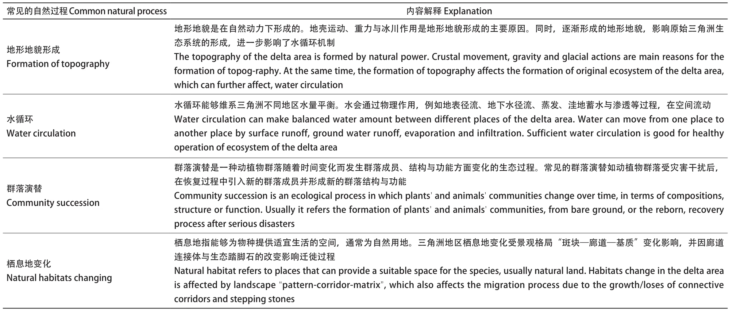
表1 三角洲地区常见自然过程Tab. 1 Common natural process in delta areas
3.2 协同性
三角洲空间的适应性体现在与其赖以生存的环境相适应,达到人与人、自然、环境的和谐,提高空间韧性,增强空间发展活力。当前,由于发展阶段、发展条件不同使得地域之间存在巨大差异,系统内各种要素互相交叠,利益多元,因此,区域间协调性显得更加必要。三角洲地区韧性规划只有运用协同的方法,才能促使系统产生空间、时间、功能上的协同。
系统与协同理念可体现在跨尺度多功能的防灾网络规划中,例如BIG 事务所系统地考虑海平面上升、气候变化及城市发展中的不确定因素,提出针对曼哈顿主岛滨水区 “U”形保护系统,对防灾网络加以优化,重塑场地,并高度适应生存、社会、经济环境(图2)。从系统多功能的结构与功能出发,既解决当前防灾问题,又统筹考虑平时作用的发挥。打造多样化的景观空间,为该区域的未来韧性海岸建设和城市发展描绘出崭新的图景,不仅回应了三角洲地区的防洪需求,也满足使用者对于自然环境的当前需求和未来期许。
3.3 底线性
保障三角洲地区在面临未来扰动时具有维持核心功能的系统底线。韧性规划要立足于底线保障。主动适应未来气候变化, 确保地区在面对风险时能够抵御扰动,保障系统核心功能地正常运转。
底线辨识可分为静态式底线保障和基于自然的动态式演进的解决方案(图3)[10-11]。静态式底线保障强调对以生存敏感性、生态系统服务功能为核心的自然基底格局进行多因子叠加分析,构建能够保障自然承载力的、具有稳定性的自然基底格局。例如“千层饼”式自然底线评估方法、现今的景观生态安全格局,都属于静态式底线保护。但静态式底线保障不利于各类信息、能量的交互。近年来欧盟等提出的基于自然的动态式解决方案,在规划中引入自然要素,增强动态性,充分利用自然过程的优势,不仅保障了自然底线,而且塑造了一种新的自然基底[12]。可综合利用潮汐、沙、风等自然过程实现规划与自然动力的结合,形成稳态基底。
3.4 预判性
预判性是韧性规划的重要属性。在面对未来不确定的扰动、特别是强扰动时,需要防患于未然。预判性的实现需要通过构建与评估可能的远期情景,作为近期规划方案的线索,并比选方案。评估未来面临的各种发展情景、风险可能造成的破坏程度,重视灰、绿色基础建设结合, 将三角洲地区韧性规划作为持续的行动,注重承前启后和发展整体性。例如,三角洲地区协同化规划与设计项目(Integral Planning and Design in the Delta,IPDD),根据对荷兰三角洲的历史演进、现状和对未来预测,通过对自然风险高、城市化增强与自然风险低、城市化减弱2种情景背景的模拟、分析,制定了相应的空间布局方案,以期为区域发展路径提供不同可能性(图 4,表 2)[13]。
3.5 韧性原则的应用
结合上述4种思维特性,韧性规划在三角洲地区的实现需要基于不同场所、不同景观特征,运用相应的规划策略。积极应用多功能性、冗余性、网络化、模块化等空间布局原则。图5显示了荷兰若干基于上述原则的典型项目。鹿特丹水广场项目(Rotterdam Watersquare)在实现对雨水冲击的缓冲、吸纳、储存的同时,提高了场地的多种功能,提升了公共活力[14];还河流以空间项目奈梅亨节点(Room for Rivers-Nijmegen)通过适度冗余策略,增加人工支流,设置溢流堤,扩大泛洪区,后退原有堤岸,打造具有休闲游憩价值的滨水公共空间[15];还河流以空间项目诺德伍德节点(Room for Rivers-Noorward)适应自然,通过网络化策略,还田于水,成功实现对河流水位的控制[16];补沙引擎项目(Sand motor)充分发挥地域性优势,让自然做功固沙,防止岸线沙土被海浪侵蚀[17];马肯湖—瓦登海人工岛项目(Marker Waddern)增加生态网络连通性,不仅吸收了周边环境的污染物,同时创造了栖息地的多样性,为候鸟迁徙、 鱼群回游提供生态踏脚石,增加生态网络连通性,同时创造了生物多样性[18];马斯弗拉克特二号码头项目(Maasvlakte II)根据地域性特点,将港口外轮廓线设计与洋流动态紧密结合,确定了预发展深水航道, 引入零污染和零地下水开采的产业,带动港口工业地区的能源转型[19]。

1 不同类型三角洲演进Delta evolution of different dominated natural powers1-1 河控型三角洲演进——以美国密西西比三角洲为例Fluvial-dominated delta evolution — Mississippi River Delta1-2 浪控型三角洲演进——以越南湄公河三角洲为例Wave- dominated delta evolution — Mekong River Delta1-3 潮控型三角洲演进——以荷兰三角洲为例Tidal-dominated delta evolution — Dutch Delta
4 构建跨尺度的“格局—连通—关键点”三角洲地区韧性规划框架
4.1 土地利用格局
以提升城市空间韧性能力为出发点,系统地研究整体格局。将基于机理驱动预测、地理空间形态模拟与水文生态模拟相结合,预测空间结构可能的演变趋势与风险场所。通过情景分析,利用已知的不确定性, 减少“未知不确定性”,从多个可能性中寻找空间发展的潜力,探索应对不同情景规划的可行性。加强区域合作和协同, 应基于综合自然边界的划定,综合生态安全格局和全域基础设施,将自然要素落实到土地利用总体规划中。重视项目对系统整体功能实现的支撑性作用,在尊重景观格局的前提下,让自然要素成为重要的设计语言, 合理选择开发与保护用地。
4.2 空间连通性
构建“流动性”载体。蓝绿网络具有不可替代的作用,是实现“流动性”的重要载体。特别是水系、绿廊,更是成为塑造城市空间形态的重要因子。当前,快速城市化过程中存在的一个突出问题是由于土地粗放利用、缺少统筹,导致空间完整度低,原本有强烈自然肌理的三角洲自然基底几乎消失殆尽,造成了严重的生境损失。由于交通系统的发展,蓝绿廊道被渠化、切断,导致原有自然径流被大幅度改变。因此,蓝绿网络建设的主要目标是将空间中现存的、潜在的生态斑块、生态踏脚石连接起来,利用自然自我修复的机制,逐步形成新的生态格局,提供更多的生态系统服务,以起到防灾作用。同时,交通网络要富有韧性,具有较强的抗干扰、抗冲击能力,要协同交通网络与蓝绿网络、灰色网络, 在软硬件方面具有足够的适应能力,增加市民使用的可选择性,保持不同空间组团之间的畅通。
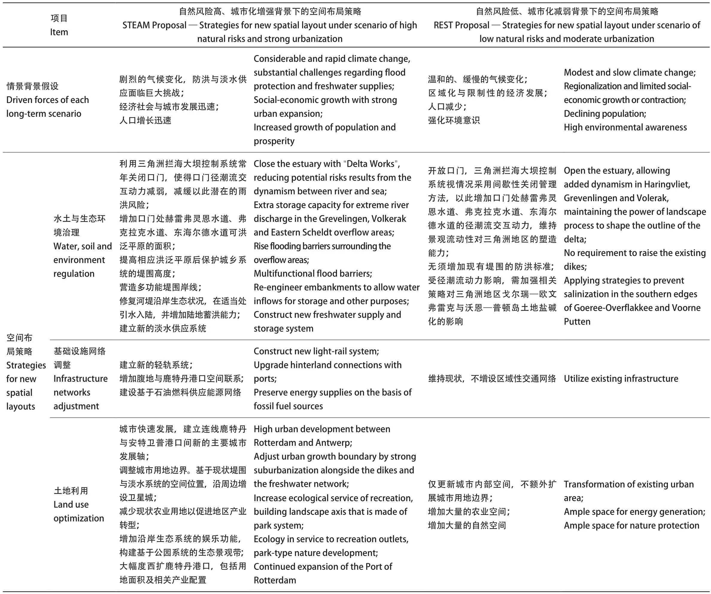
表2 不同远期情景假设条件下荷兰三角洲地区空间布局解决方案策略解析Tab. 2 Analysis of applied spatial strategies of sub-systems in planning proposals under different background of long-term scenarios
4.3 关键点策略
加强对韧性技术在各类空间节点的研究和应用。针对三角洲敏感性高、经济发展迅速、雨洪—生态韧性低、易受外部扰动的特点,从空间、时间和功能3个维度开展韧性技术系统研究,探讨关键性要素及其组合方式对系统目标实现的驱动机理,研究不同控制要素间的耦合机制及对系统目标的集成影响。需要结合场地的实际情况,编制相应的规划内容。要将有利于提高系统韧性的一些原则,如地域性、多样性、多功能性、冗余性、网络化、模块化等规划原则应用到三角洲地区各关键点的工程实践中。结合空间网络, 打造关键点“海绵体”。
4.4 集成应用传统生态智慧与现代技术
合理利用人工介入和生态智慧,使得三角洲地区跨尺度空间形成一个整体,协同应对未来气候与发展情景的变化。例如,圩田区域地势平缓、泥沙极易沉降。顺水而为、适度改造是圩田类空间规划的核心理念。在充分尊重自然汇水过程的基础上,将低洼处无序的水流塑造成自然的水网,实现疏浚排水,尽可能将圩田河渠连通形成网络。利用现代技术将圩田水渠贯通,使其具有排水、调蓄、航运、灌溉、景观等综合功能。定期疏浚河道,将淤泥用于垫高圩堤和戗岸,修复被破坏的圩田。需要设置多重防灾体系,形成一定的防灾冗余条件, 实现分级防灾体系,分区排涝。
4.5 跨尺度协同与管理措施
生态规划管理、防洪规划管理、智能化预警系统、应急调度管理等方面,建立跨尺度、跨部门的统一协调机制。改变仅以局部视觉美学和空间构成学为依据的传统城市规划的评价标准。
5 小结与展望
韧性规划作为三角洲地区规划转型的新理念,通过对自然基底的保护,对自然过程的引入,对空间格局的重塑,应对未来“社会—经济—生态”三者的挑战,形成更加合理的“生产、生活、生态” 的城市空间,并能够与国土空间规划“三区三线”技术性指南划定形成有机联系,迎合生态文明建设发展的要求。
尽管目前关于三角洲地区韧性规划的研究尚处于起步阶段,但从“抵抗自然”走向“与自然合作”的趋势已经显现。当前在实践中要特别注意以下4点。
1)高度重视三角洲地区自然基底的脆弱性,深刻认识韧性思维的系统性、协同性、底线性和预判性,从一味依赖技术力量这一现象转变为将传统生态智慧与现代技术相结合。
2)基于预判式过程。以情景作为线索,构建更加合理的规划方案。未来环境变化具有不确定性。对情景的展望可以减少“不确定性”情景发生的概率,为构建合理的近期规划方案提供科学依据。要结合地域特点,积极探索土地利用方式和空间格局,合理设置土地扩展的阈值。
3)兼顾鲁棒性与适应性的功能分区管控体系。鲁棒性分区指该分区在外力作用下不易发生形态和功能上形变的空间分区。适应性分区指该分区在外力作用下发生形变、但不损坏空间的分区。在鲁棒性空间分区,主要采用以静态式的底线保障方案,以“千层饼”式自然底线评估方法绘制景观生态安全格局。在适应性空间分区,可以采用基于自然的动态式演进的解决方案,确保景观要素的“流动性”。在近期规划中采用兼容鲁棒性与适应性的规划导则,保证空间结构自身的稳定性,以适当手段吸收和缓冲外界变化导致的形变。
设计导向,基于自然过程的动态性原则,优化生态系统,应拿捏好规划中自然、农田、城市等多种重要的环境系统,通过整合人工与自然力量,塑造海陆统筹的三角洲地区空间景观格局,适应未来动态变化以及发展需要。
致谢:
感谢华南理工大学建筑学院林广思教授、荷兰代尔夫特理工大学斯特芬·奈豪斯副教授、Taneha Bacchin 对本文的指导。
图表来源:
图 1-1、1-2 来自参考文献 [5];图 1-3 来自参考文献[6];图 2 来自 Rebuild by Design (http://www.rebuildbydesign.org/);图 3 翻译自参考文献[10];图 4 来自参考文献 [13];图 5 为作者自绘;表1、3 为作者自绘;表2 改绘自参考文献 [10]。
With rapid urbanization process in the world,delta areas have made remarkable achievements in urban construction, as a result of rapid development in recent decades. However, the ecological problems accumulated over the years have also become more prominent, especially for the increasing spatial vulnerability. Extensive land use and reclamation caused scarce land resource, lowering environmental carrying capability. On the one hand, ecological system services were declining, as a consequence of the destructive original natural basement. On the other hand, various natural disasters, such as heavy precipitation, river flooding and tidal invasion,geological hazard, environmental pollution, etc.occurred frequently in recent years. For instance,in 1994, 1998, and 2008, several major floods hit the Pearl River Delta[1-2]. More than 10 times storm tides and 40 times heavy red tides have invaded since 2006. Land subsidence, as secondary disasters also happened for several times between 1994 and 2009, causing significant property losses in the Pearl River Delta. New Orleans suffered from Hurricane Katrina in 2005[3], leaving the city almost in ruins, as a result of the flooding and land subsidence. In 1993 and 1995, the Netherlands suffered from two severe flooding, which resulted in heavy losses in both human life and properties,and made the Dutch government reconsider spatial planning strategies for the future[4].
Due to weaker environmental carrying capacity and frequently challenging natural disasters, delta areas have become ecological sensitive places that seem hard to be developed, with constant pressures of increasing population growth social-economic requirements. Current planning theory and methodolgy in delta areas are required to be shifted to enhance resilient capacity. When looking back our experience, the traditional economic-oriented pathways with deterministic blueprint planning outcomes seems not enough to adapt to potential future challenges either in macro strategies or local practices. Uncertain disturbances such as natural disasters caused by climate change urge planners to change their thinking mode, by making advantages of dynamic landscape and preparing for future risks. Only in this way can delta areas withstand the destabilization and have abilities to quickly return to stable states after disasters.
1 Characters of Delta Landscape
The delta area has a special landscape composition with dynamic mechanism. The natural basement, being the carrier of the formation and development of other spatial elements, provides space, materials and acts for shaping infrastructure networks and urban-rural occupations. Green-blue systems are not only important spatial networks of generating stable landscape in delta areas, but also are main indicators to guide actions for urban-rural patterns’ development, protection or remove. The complex landscape of delta area can be classified into three categories according to their dominated natural power, namely fluvial dominated delta,wave-dominated delta and tidal-dominated delta[5],representing the shaping processes of delta areas dominated by sediment input, wave energy and tidal energy (Fig.1)[6]. Delta areas are constrained by themselves’ natural laws, and thus, different natural processes in delta areas vary between each other according to specific rhythms. The speed of these processes can be fast or slow, with quite different operational scales and principles (Tab.1), which can greatly affect shaping and reshaping spatial layout for the future. Therefore, it is necessary to first have an in-depth exploration of the spatialtemporal evolution of the delta area, to understand the dynamic operation of the system in natural basement, infrastructure networks and urban-rural occupations, and then to transform our value from“resisting disasters” to “adapting nature”, in order to optimize the situation of existing site.
2 Core Capabilities and Characteristics of Resilient Planning
Based on the above understanding, we believe that the resilient planning in delta areas can be applied as a new concept for the transformation of planning paradigm in response to the special landscape composition with dynamic mechanism, meanwhile overcoming conflicts between urban-rural expansion and insufficient environmental capacity.
The term “resilience” , originated from Latin word “resilio”, often appears in regional or urban planning in recent years, which means “returning to its original state after an object is disturbed”and evolves into “resile” in modern English. Since Holling[7]first proposed it in 1970s, the concept of resilience has been widely used. Many famous international research institutions have elaborated the meaning of resilience during their practices. For instance, International Intergovernmental Panel on Climate Change (IPCC) described that“resilience is the ability of absorbing interference and maintaining the core structure and function of system”[8].
The concept of resilience has experienced several development stages from engineering resilience, ecological resilience to evolutional resilience, in pursuit of concept from single steady state to a more emphasis on continuous adaptation, by shifting the research objective from linear to nonlinear system. Evolution resilience reflects the process from recovering and maintaining ability to adaptive and learning/transforming ability[9]. It is believed that recovery and maintenance ability reflects from the system’s robustness of its baseline, while adaptive ability reflects the prediction of system when it comes to the ability to cope with the sudden disturbances and to adapt to the surrounding environments.learning ability from the experience of dealing with disturbances and transforming these lessons into planning actions, in order to guide next planning actions. Shortly, the capabilities of robustness,adaptability, and learning/transformation can be regarded as core competencies of resilience planning in delta areas.
Compared with the other current planning methods, resilient planning in delta areas has five distinctive characters, together with the necessary knowledge inputs of complex system. Resilient planning aims to constantly organize with natural and unnatural elements, scales, short and long term spatial visions, exploring balanced relationship between each of them. First, resilient planning highlights the principles of natural basement.When there are conflicts between natural and unnatural areas, it is important to leave space for nature according to its self-organization functions.That means, the better way to develop in delta areas should emphasize the baseline combining with the nature, especially water and green system. Second,resilient planning should comprehensively evaluate various impact factors of future uncertainties. The overall evaluation factors including the disaster frequency, defensiveness, affected regions, losses,the secondary disasters as well as the recovery time of the catastrophe in history needs to combine with the layer of current states, in order to make predictions for challenging places in space by mapping technologies. Third, resilient planning requires to consider about possible scenarios,as background but important information for planning “No-regret” strategies. Scenarios can provide tendencies to be thought about. Then different spatial strategies with related spatial layouts to respond to these scenarios can be used to present different possibilities for the long-term future. “No-regret” strategies for spatial layouts can take a series of distinctive principles for improving the robustness, adaptability, and learning/transformation capabilities, such as diversity, multifunctionality, redundancy, modularity, multi-scale networking and connectivity. Fourth, resilient planning is not the opposite of other planning theories and methodologies. Resilient planning relies on the comprehensive master of the baseline and trend highlighting the further understanding of natural condition, social and economic-driven factors. The concept of resilience should shift from the resisting the disturbance to allowing the disturbance, taking the uncertain disturbance as normality to work with. With new planning techniques such as “big data” introduced, the opportunities for realizing these resilient criteria with well-prepared scientific spatial layouts and typical sections can be achieved.
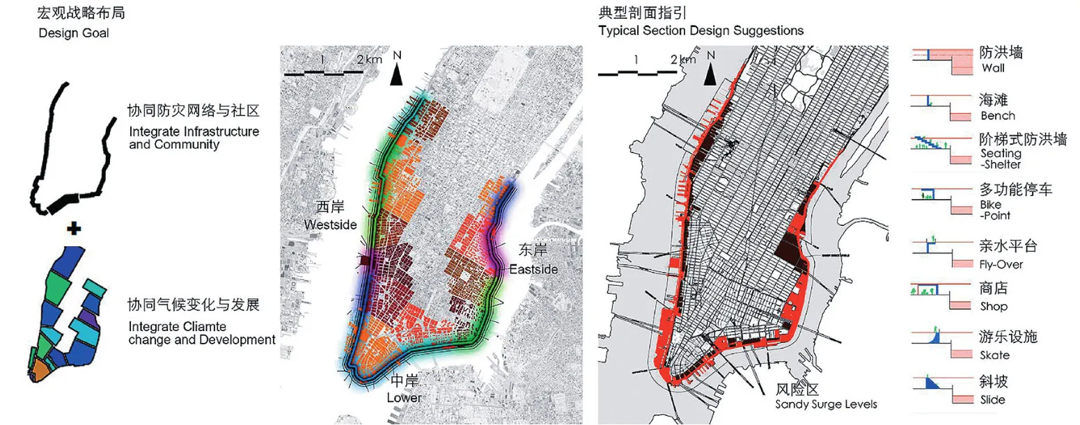
2 “BIG U”方案体现系统性、多尺度协同规划设计的观念Systematic, multi-scale collaborative planning and design— Example of “BIG U”
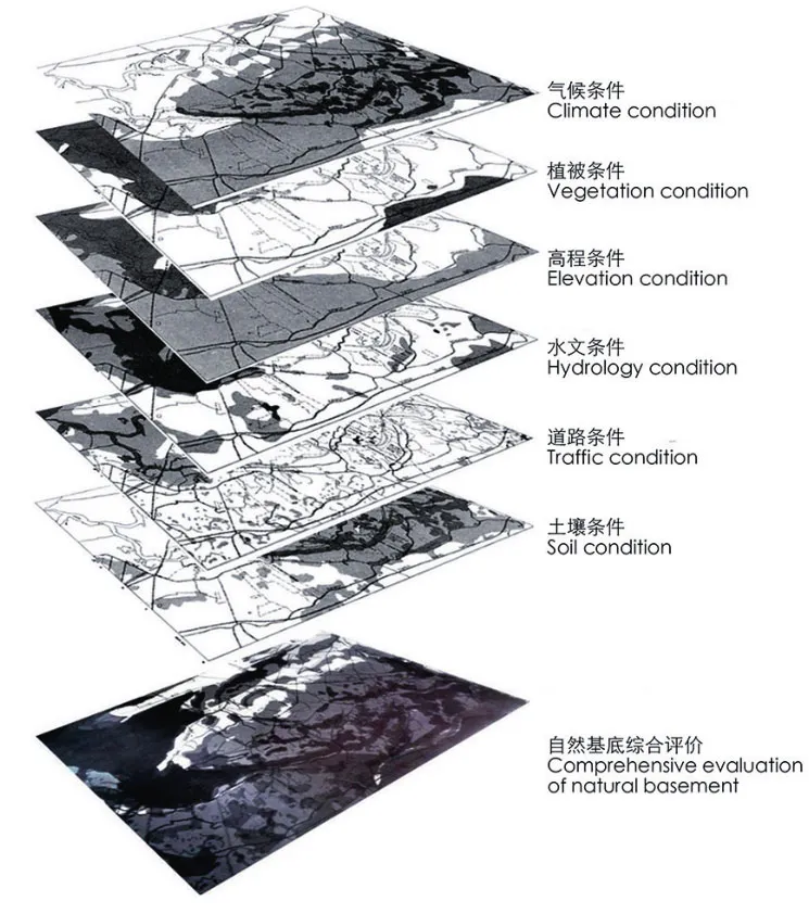
3 传统的“千层饼”底线格局研判方法Research and judgment method of the traditional “multilayer steamed bread” bottom line pattern

4 不同远期情景下的荷兰南三角洲方案:STEAM(左)与REST(右)Scenarios thinking in South Dutch Delta:STEAM (Left)and REST (Right)
3 Thinking Characters of Resilience
3.1 Systematic Thinking
The delta area is a complex system involved in scales with strong uncertainty, which coexists with nature and unnatural actions. Planning outcomes,such as new spatial layouts with typical sections are required to include the information of multi-scale spatial researches, such as multi-scale water, green system understanding, etc. Planners should build up their understandings, by reduction drawings of different specific subsystems and elements, then to reconstruct new understanding of relationships based on studying the interactions among whole system, subsystem, elements, outside environments.
3.2 Integrative Thinking
Integration reflects harmonious relationship between human and nature to improve space resilience. Due to the overlapping of various elements of system and the diversity of different interests, integration is necessary. Integrative thinking also means that the different subsystems have their own freedom to develop within the limits of whole system interest.
A famous practical example can be learned is in New York, deriving from competition outcomes of “Rebuild by design” with several planning proposals for multi-scale and multi-functional disaster prevention networks. For instance, “U-shaped”system of 14 km Manhattan waterfront boundary proposed by BIG team is of great interests to the resilient concept (Fig.2). Their proposals was made by systematically considering the climate change and uncertain surrounding communities’ development,with technic prediction of spatial mappings to find out both opportunities and challenges for future.Based on those, their proposal optimizes the disaster prevention networks, from a bare hard-surface dyke system to vivid public waterfront areas, by making the highly adaptive framework with three key parks and several suggestions for both roads and waterfront sections. Their proposal solves both the current spatial issues and provides strategies for future disaster prevention, by transforming high risk waterfront areas to a multi-function public area that citizens can involve. Furthermore, different typical sections’ models are suggested to complete with this new “U-shaped” spatial layout. Like guidelines, the selection of these sections will be decided by different users’ of surrounding communities.
3.3 Baseline Thinking
The resilient planning is based on baseline thinking in order to keep system stable even if system is subjected to great disturbance, by understanding the self-organization characters of delta natural landscape. It should be based on natural basement by actively adapting to future climate change, with making advantages of landscape and introducing natural language into new spatial layout.
In planning practice, there are two ways to identify sensitive natural baseline based on the theory of landscape ecology. One is based on static layer-based perspective and the other is natural-based solution based on dynamic evolution perspective, which means that dynamics of natural power can also be applied for planning languages (Fig.3)[10-11]. The static method emphasizes on the analysis of layering of multiple spatial factors for the evolution of comprehensive maps to find challenges and opportunities, however, the static method is not conducive to coping with dynamic changing of the environment and the interaction of various types of material, information and energy transformation. In recent years, the natural-based solution introduced the processes of natural elements in planning process by utilizing the advantages of natural processes, which can use the power of nature to replace the artificial technology[12]. An example in the coastline shows how the concept of “natural-based solution” can work in practice.
3.4 Scenarios Thinking
It is essential to prepare strategies aiming at different future possibilities. In scenario thinking,“No-regret” strategies should be established based on the understanding of existing situations as well as different possibilities of long-term scenarios,where the green, blue and grey infrastructures will be combined under the background of the sustained action. For example, Integral Planning and Design for the Delta (IPDD) project has simulated 2 scenarios(High natural risk with high urbanization; Low natural risk with low urbanization) and corresponding 2 spatial solutions in Dutch Delta based on the knowledge of historical evolution, current status and future projections. (Fig.4, Tab.2)[13]. They are useful to establish more comprehensive “No-regret” strategies with process-based spatial layout, with the feedback evaluation in finding both similar and changeable places in both scenarios.
3.5 Adapting to Local Conditions, Based on Above Four Thinking Characters
Apart from traditional planning principles,resilient planning needs to apply special principles to distribute a new spatial layout, Fig.5 show typical projects with related landscape features in the Netherlands. Project “Rotterdam Watersquare”enhanced the public vitality of the site by buffering,absorbing and storing rainwater impacts[14]; Project“Room for Rivers - Nijmegen” reduced peak water discharge through creating a by-pass channel. Related strategies like expanding floodplain, retreating the original embankment, and creating a waterfront public space with leisure recreation value[15]. Project“Room for Rivers - Noorward” adapted to nature,through depoldering technologies by returning agriculture land to the water body[16]; Project “Sand Motor” made use of advantage of regional natural processes to fix sand and prevent coastline sand from being eroded by waves[17]; Project “Marker Waddern” not only absorbed pollutants from surrounding environment, but also created habitat diversity by providing ecological stepping stones for bird and fish migration and increasing the surrounding biodiversity[18]; Project “Maasvlakte II” was based on regional characteristics. The outer contour of the port was closely integrated with the dynamics of ocean currents, which defined the deep water channel and introduces zero pollution and zero groundwater mining industries[19].
4 Research Framework of “Pattern-Connectivity-Strategic points”
4.1 Land Use Pattern
It is important to systematically study overall landscape pattern to make balance between protection and development of land use by highlighting the ability of resilience. It is necessary to combine techniques like geographic big data simulation, GIS database, and spatial hydrological simulation to predict the backbone of spatial structures. The natural elements are used as important language for planning,with selected strategic points.
During this process, the corresponding spatial evaluations, such as environmental carrying capacity evaluation, land suitability evaluation, and space risk assessment, can provide a reference for delineating the final scientific land use pattern.They are essentially systematic and scientific spatial mapping outcomes, which are basis for guiding the final spatial layout into the right direction. When there is a contradiction in the space demarcation, it is necessary to abide by the principle of ecological priority and reserve buffer space for future growth.
4.2 Increasing Connectivity for Flowspace
Connectivity can be achieved by building“flowspace” carriers. The blue-green networks are important carriers for generating flowspace. Blue corridors and green corridors are elements for shaping new spatial structures. At present, a serious problem is that green-blue networks are fragmented,which causes runoffs blocked and habitat loss.Therefore, the main goal of blue-green network reconstruction is to connect potential green spaces,water bodies and wetlands to form large context.
4.3 Strategic Points for Resilience
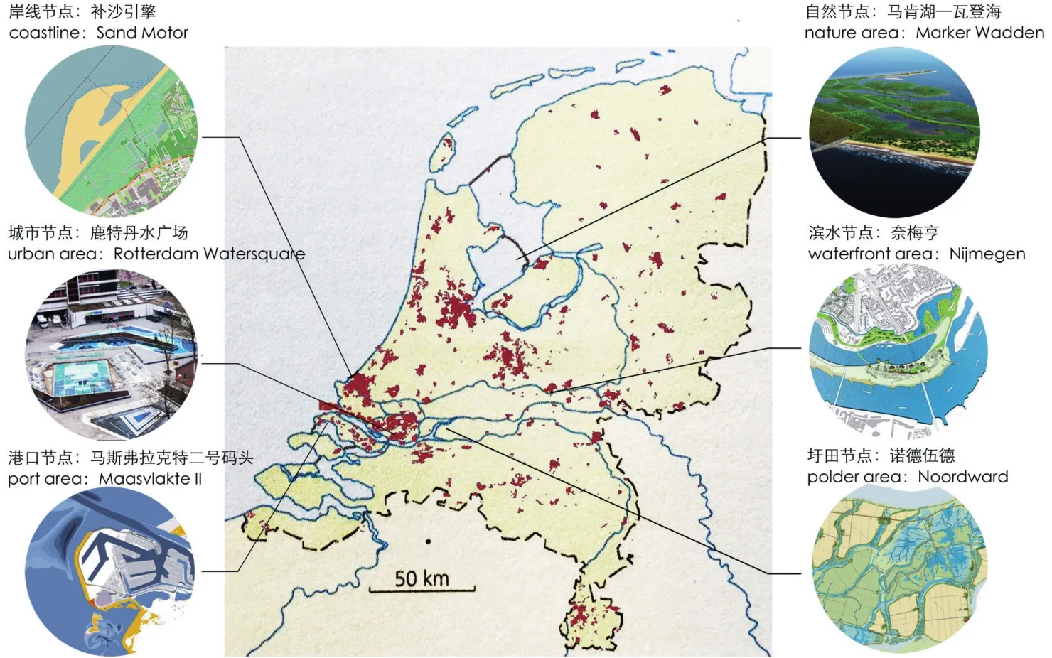
5 典型节点项目分布Spatial distribution of typical projects
Strengthen the research and application of resilient technology in various strategic points. In view of the high sensitive delta areas, the researches for various strategies which adapt to local scale should be carried out from three dimensions of space, time and element. It is necessary to integrate the actual situation of each strategic point to compile whole planning. At the same time, some technologies such as regionality, diversity, redundancy, network,and modularity, etc. are helpful to improve systematic resilience should be applied in practices.
4.4 Collaboration with Management Measures
In the aspects of infrastructure construction,ecological planning management, flood control management, intelligent warning system,emergency dispatch management etc., unified coordination mechanism between cross-scale and multi-sector should be built. Planners should pay attention to the coordination of the project with the regional environment and urban landscape.The evaluation criteria of planning based on visual aesthetics should be changed into “social-economicecological” comprehensive goals.
4.5 Robust and Adaptive Zones
Resilient planning of the delta area should take into account both robust and adaptive zones for different ways of guidelines. Robust zone refers to the spatial zone that is not easily deformed in structure and function under external disturbances.Adaptive zone refers to the spatial zone that can be changed in structure and function under external disturbances, but it still keeps abilities of selforganization. They can be set in high risk areas with high ecological vulnerability. We believe that in robust zones, the static methods for generating baseline can be used to draw the landscape ecological security pattern with the “layer model”. In adaptive zones, natural-based solutions can be used to ensure the “flowspace” of landscape elements. At the same time, it is possible to take into account the phase setting to connect the behavior of adaptive zones with long-term scenarios. Appropriate means can be applied to absorb external disturbances.
5 Conclusions
The new concept of resilient planning has been proposed for delta areas recently, which has developed a more rational delta space characterized with harmonious relationship of “production, living,ecology” zones in accordance with the requirement of ecological civilization construction by protecting natural baseline, connecting the natural processes,reshaping the spatial pattern in the face of the“society-economy-ecology” challenges.
The resilient planning of delta areas helps to promote the implementations of Substitutability.First, the problem is compounded by its fragility of natural baseline to delta areas, and it is necessary to deeply understand the systematic, integrative, baseline and scenarios thinking, and to combine the traditional ecological wisdom with modern technologies instead of relying on the data and techniques blindly.Scenarios can help to build “No-regret” spatial strategies and corresponding spatial layouts. The increasing expectations of long-term scenarios are good for reducing the probabilities of uncertainty and providing a scientific basis for scientific planning in the short-term. Second, it is important to provide spatial principles of both robustness and adaptation into a comprehensive spatial layout map. Robust zone refers to the spatial zone that is not easily deformed in structure and function under external disturbances. Adaptive zone refers to the spatial zone that can be changed in structure and function under external disturbances, but it still keeps abilities of selforganization. Third, manipulating landscape pattern with dynamic mechanism can be shaped to adapt the dynamic change and development need accompanied by integrating the artificial and nature power in the important environmental systems such as nature,rural, urban areas.
Although the characteristics of resilient planning are still in cognitive stage, the trend has emerged. The guiding value has shifted from“Resisting against disaster” to “working with nature”. It is time to combine traditional ecological wisdom with modern technologies for resilient development of delta area.
Acknowledgements:
We would like to thank Prof. Lin Guangsi, the School of Architecture, South China University of Technology;Associate Professor Steffen Nijhuis and Taneha Bacchin,the faculty of architecture and build environment, Delft University of Technology, for their help to this paper.
Sources of Figures and Tables:
Fig. 1-1, 1-2 from reference [5]; Fig. 1-3 from reference [6];Fig. 2 from Rebuild by Design(http://www.rebuildbydesign.org/); Fig. 3 translated from reference [10]; Fig. 4 from reference [13]; Fig. 5 is made by author; Tab.1 are made by author; Tab. 2 is revised from reference [10].

