澳大利亚新南威尔士州蓝山海泽布鲁克纪念公园
科可里咨询私人有限公司
海泽布鲁克是地处大西部高速公路沿线上的村庄之一,它横跨蓝山,连接了悉尼与新南威尔士州西部广阔的农业景观。位于海泽布鲁克北部的大蓝山世界遗址壮观而粗犷,具有重要的国际意义。但由于高速公路廊道的物理限制与其所包含的丰富历史遗产和风景价值,这成为新南威尔士州道路和海事服务机构(RMS)对大西部公路升级改造过程中最大的挑战。
纪念公园位于海泽布鲁克村,是一个地方公园,由于它在高速公路升级工程期间被用作工厂仓库和储存区,而受到严重的影响。因此,在伍德福德村和海泽布鲁克村之间进行“纪念公园”的恢复成为升级大西部高速公路的重要任务。公园的恢复工程于2014年成功完成,并为道路基础设施项目如何通过创建高质量的公共开放空间而使当地居民受益提供了一个很好的范例。
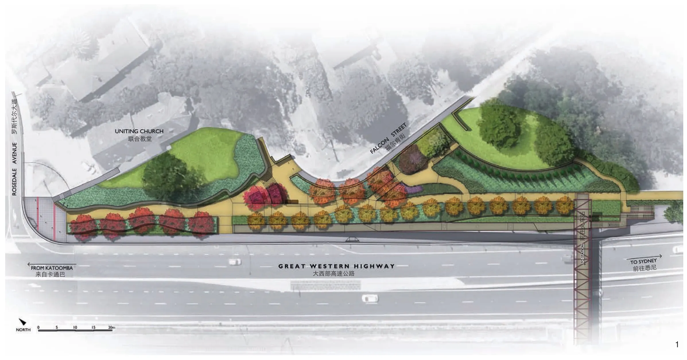
1 纪念公园概念规划图Memory park concept plan
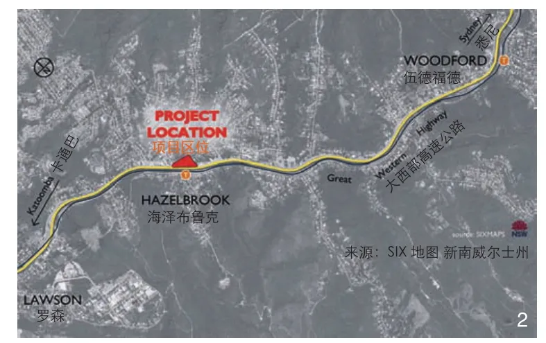
2 项目区位图,显示其地处蓝山,在悉尼的西边Location plan showing Memory Park in Blue Mountains west of Sydney
纪念公园占地约3 300m2,是当地一个富有吸引力且令人放松的公园,拥有重要的文化遗产和景观价值。它实现了海泽布鲁克村中心与相邻的住宅区及学校间安全便捷的连接。公园外沿的自行车道与人行道连接到高速公路上一座新建的桥,为村中心和火车站、商店与铁道南部的居住区间构建了一条安全的通路。
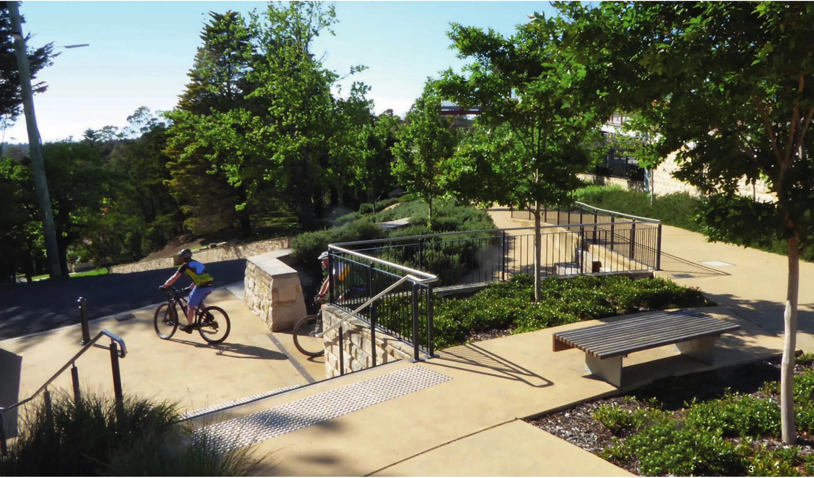
3 纪念公园内部的台地高程变化Terraces address level changes within Memory Park
美国优斯集团(URS)代表新南威尔士洲道路和海事服务机构(RMS)聘请了科可里咨询公司为公园修复工作准备详细的城市和景观设计资料,以及伍德福德村和海泽布鲁克村之间大西部公路升级所需的景观设计资料。
纪念公园曾承办每年的澳新军团纪念日典礼,这是它所拥有的文化遗产价值之一。虽然原来的战争纪念馆已经搬迁到附近的另一个公园里,但纪念公园的文化价值已通过公园恢复设计时所包含的讲解图而获得了公众的认同。
科可里咨询公司与URS的工程师合作,通过精心的城市设计应对陡峭地形带来的挑战。为了处理陡峭的斜坡并开拓道路,设计采用了一套包括坡道、楼梯、挡土墙和露台的综合体系,将公园的道路和坡道设计成一条居民和学生进入海泽布鲁克村的重要路线,同时也是穿过高速公路到海泽布鲁克火车站的人行道。园路与坡道下方大量贯穿公园的地下设施使得场地规划变得更加复杂,因此挡土墙基础和雨水排放系统的设计避免了与它们发生冲突。
设计保留了场地现有的成熟树木,并种植了新的乔木、灌木和地被植物,以着重突出蓝山典型的文化景观特征。公园种植的新树种选择是在与蓝山委员会和当地社区进行协商后决定的。帚状北美鹅掌楸(Liriodendron tulipifera ‘Fastigiatum’)被选为行道树,沿人行斜坡的基础成行种植,连接至人行天桥。它柱状的树形非常适合种植在桥面一侧狭窄的空间中,同时还可以保留从纪念公园望向蓝山国家公园的视野,在秋天时浓郁的金黄色树叶能营造出令人难忘的公园特色。其他的树种还包括观赏梨树和紫薇,它们会在春季、夏季开花,营造出季节性景观。
对公园遗产价值的研究还包括从州立图书馆获取的图像,和当地专家对遗址解释性标识提供的建议。同时,通过设计一个砂岩墙纪念弧并沿墙列植18棵柏树,来纪念在战争中牺牲的当地士兵。
随着景观的日益成熟,新种植的树木开始在整个公园内围合并定义空间,加强了穿行公园时或坐下来感受全新景观环境时的体验感。 同时,露台、坡道和楼梯的连接系统提供了丰富多样的观景体验。此外,连接高速公路的人行天桥坡道为公园提供了有趣的鸟瞰视角。游客可以在穿越公园时体验各种不断变化的景观,还可以从坡道和桥上的瞭望台中观赏全景。
当负责高速公路升级工程的承包商进行清算时,发现纪念公园恢复工程完成的时间延长了。 当地居民渴望确保纪念公园能尽快完工。公园的设计圆满地回应了与当地社区和蓝山市议会协商的结果。议会的支持信证实了当地居民对公园升级设计时所抱期望已成功实现,如信中提到的 “它巧妙地解决了连接性、便利性、实质性和地方特性等会相互影响的问题,为资产所有者——理事会提供了强有力的财富”。
高速公路上方新建的人行天桥替代了原来的平交路口,通过一个入口坡道连通了海泽布鲁克村和火车站,避免了机动车与骑行者、行人在此发生交通事故的可能。
在进行场地的综合分析时,我们特别创建了一个三维计算机模型,在设计过程中用它来协助处理具有挑战性的地形,以及在社区咨询期间向人们讲解公园设计。作为主要道路基础设施项目的一部分,这个公共开放空间的可视化和设计,成为风景园林设计师日常工作领域中一个日益重要方向的案例。
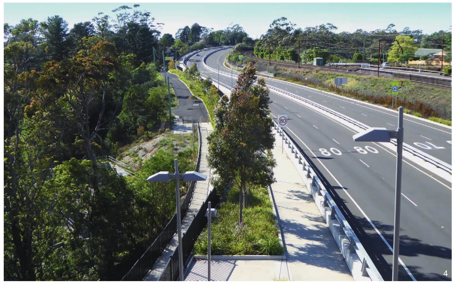
4 从人行桥上沿大西部高速公路眺望的景观(纪念公园位于图片左侧)View from pedestrian bridge along Great Western Highway with Memory Park on left
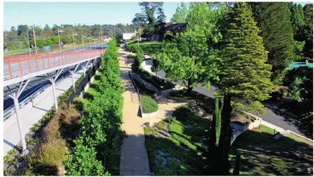
5 从人行桥的观景台上看到的公园景色View of Memory Park from pedestrian bridge lookout
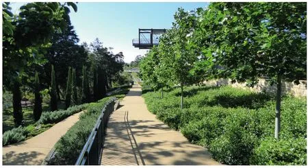
6 在中央园路上可以看见人行桥的瞭望台Central path with pedestrian bridge lookout visible above
纪念公园的恢复正在为建设一个健康、包容和强大的海泽布鲁克社区而做出重大贡献,它连接了海泽布鲁克村中心与火车站,通过新的人行天桥为当地居民和学生提供安全便捷的步道和自行车道。同时,公园还为使用者提供了亲近自然、沉思及与人社交等调节情绪的机会。
如今,纪念公园通过在海泽布鲁克商业中心、火车站和相邻住宅区之间提供安全便捷的连接,为当地经济做出了重大贡献。
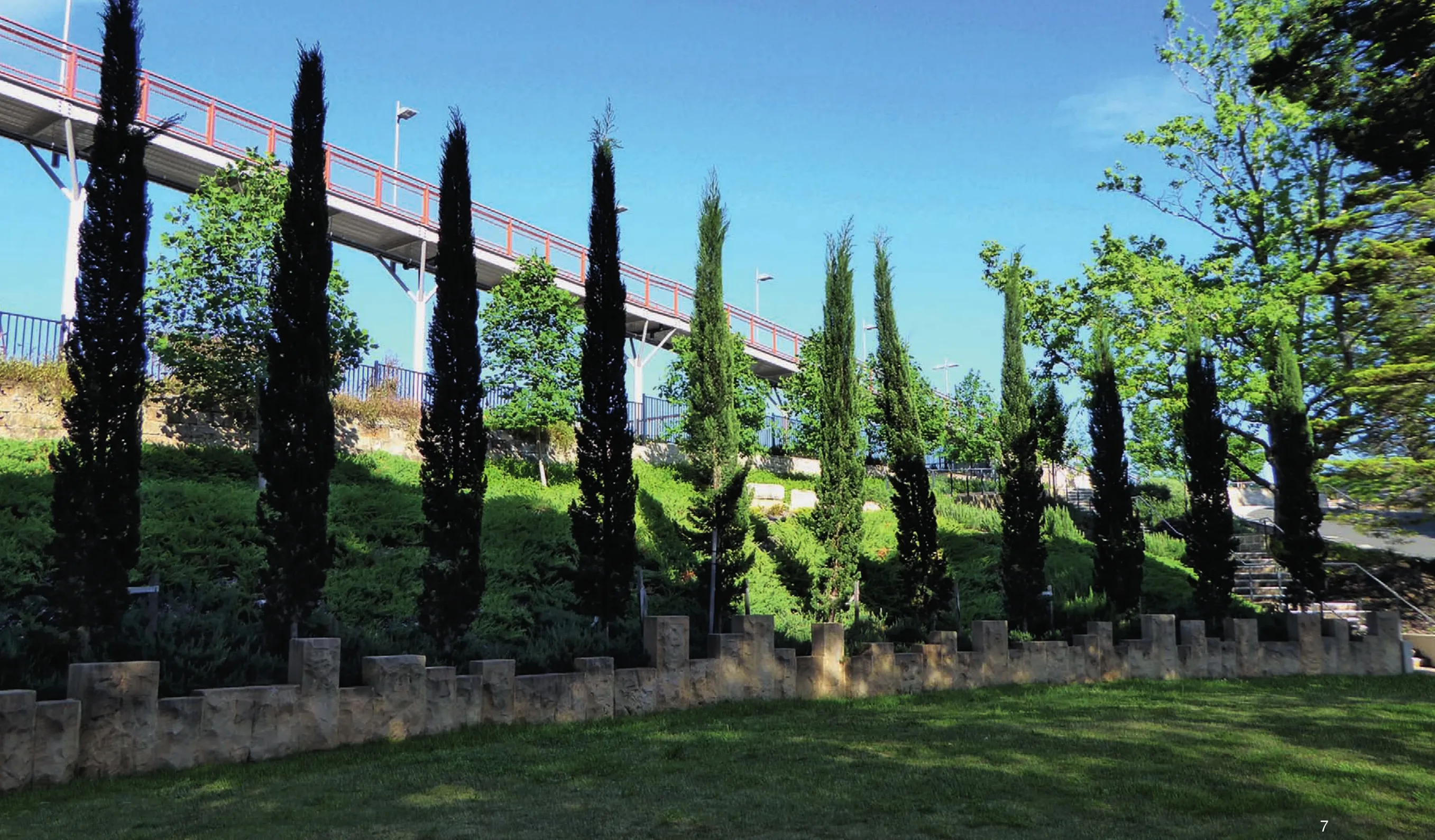
7 纪念当地士兵的柏树和砂岩墙Cypress pines & sandstone wall form memorial to local soldiers
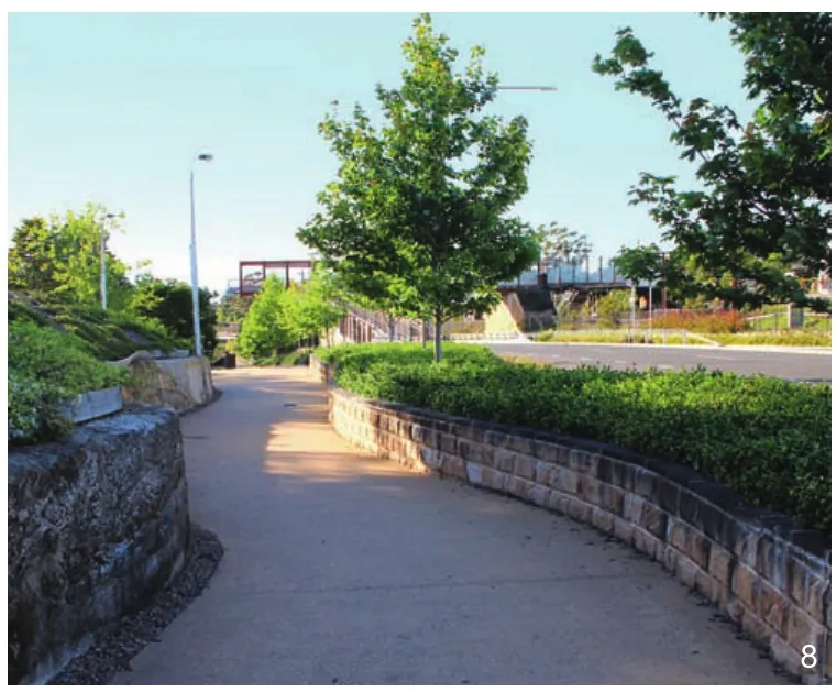
8 从海泽布鲁克村中心进入纪念公园的道路Entry path in to Memory Park from Hazelbrook village centre
(编辑/王一兰)
项目区位:海泽布鲁克村,蓝山,新南威尔士州,澳大利亚
项目面积:3 300m2
业主单位:美国优斯集团(URS)& 新南威尔士州道路和海事服务机构(RMS)
合作公司:美国优斯集团(URS)& 蓝山市议会
设计团队:科可里咨询私人有限公司
设计时间:2013年
竣工时间:2014年
图片来源:诺埃尔 科可里
翻译:钱蕾西
校对:孙越
Hazelbrook is one of a series of villages located along the Great Western Highway that runs across the Blue Mountains and connects Sydney with the broad agricultural landscapes of western NSW.The Greater Blue Mountains World Heritage Area located to the north of Hazelbrook is a spectacular and rugged landscape of international significance.
Upgrading of the Great Western Highway presented NSW Roads and Maritime Services(RMS) with one of its greatest challenges due to the physical limitations of the highway corridor and the rich heritage and scenic values it contains.
Memory Park at Hazelbrook village is a local park that was severely impacted by the highway upgrade works during which the park was used as a works depot and storage area.Restoration of Memory Park therefore formed a significant part of the Great Western Highway upgrade between the villages of Woodford and Hazelbrook.The very successful outcome of the park restoration completed in 2014 provides an excellent example of how road infrastructure projects can benefit local communities through the creation of high quality public open space.
Memory Park provides an attractive and relaxing local park covering some 3,300m2with significant cultural heritage and landscape values.The park allows safe and convenient connectivity between Hazelbrook village centre and adjoining residential areas and schools.A pedestrian and cycle ramp along the edge of Memory Park connects to a new pedestrian bridge over the Highway that provides safe access between Hazelbrook village centre and railway station as well as shops and residences located south of the railway.
Corkery Consulting was engaged by URS on behalf of RMS to prepare detailed urban and landscape design documentation for the Park restoration in addition to landscape design documentation of the Great Western Highway upgrade between Woodford and Hazelbrook.
The cultural heritage values associated with Memory Park include its historic role as the site for annual Anzac Day ceremonies.Although the original war memorial has been relocated to another nearby park the cultural values are acknowledged by interpretive graphics that were included in the park upgrade design.
Challenges created by steep topography were addressed through careful urban design by Corkery Consulting working in collaboration with URS engineers.To deal with the steeply sloping site and provide for universal access the design incorporates an integrated system of ramps,stairs,retaining walls and terraces.Paths and ramps through the park form essential routes for residents and school students accessing Hazelbrook village and the pedestrian cycle ramp across the highway to Hazelbrook railway station.Site planning was further complicated by extensive underground services that were accommodated below the paths and ramps running through the park.Retaining wall footings and stormwater drainage systems were designed to avoid conflicts with the underground services.
Existing mature trees were retained and new plantings of trees,shrubs and groundcover carried out which is focused on the cultural landscapes character typical of the Blue Mountains.The species of new trees planted in the park were selected in consultation with Blue Mountains Council and the local community.Tulip tree Liriodendron tulipifera ‘Fastigiatum’ was selected as a feature tree planted as a row along the base of the pedestrian ramp connected to the pedestrian bridge.The columnar form fits the narrow space adjoining the bridge ramp while maintaining views over the park to the Blue Mountains National Park.The rich golden yellow foliage in autumn creates a memorable feature of the park.Other species include Ornamental Pear and Crepe Myrtle,which provide seasonal blossom flowers in spring and summer.
Research on the heritage values of the park included the acquisition of images from the State Library and heritage advice from a local expert to provide content for interpretive signage.A curving sandstone wall was constructed to form a memorial arc and a row of 18 Cypress Pines were planted alongside the wall to commemorate local soldiers who died in war.
As the landscape matures the newly planted trees are beginning to define spaces throughout the park and reinforce the experience of moving through the park or sitting to enjoy the new landscape setting.The connected system of terraces,ramps and stairs provide a diverse range of view opportunities.In addition the pedestrian ramp connected to a new pedestrian bridge over the highway provides an interesting aerial perspective of the park.Visitors can experience diverse and constantly changing views as they move through the park and enjoy panoramic views from the ramp and bridge lookout.
The time taken to complete the restoration of Memory Park was extended when the contractor responsible for the highway upgrade went in to liquidation.Local residents were understandably anxious to ensure that Memory Park was completed as soon as possible.The park design successfully responded to the outcome of consultation with the local community and Blue Mountains City Council.The letter of support from Council confirmed that the expectations of the local community have been successfully met as indicated by the following quote from the letter,“its clever resolution of the competing issues of access,amenity,materiality and local identity provides Council—the asset owner—with a robust legacy.”
Replacement of pedestrian level crossing with new pedestrian bridge over the Great Western Highway connects Hazelbrook village to the railway station by a universal access ramp that has eliminated traffic accidents involving pedestrians and cyclists with highway traffic.
A feature of the comprehensive site analysis was the creation of a 3-D computer model that was used to assist the design process to deal with the challenging topography and assist in explaining the park design during community consultation.Visualisation and design of this public open space as part of a major road infrastructure project is an example of the increasingly important area of work for landscape architects.
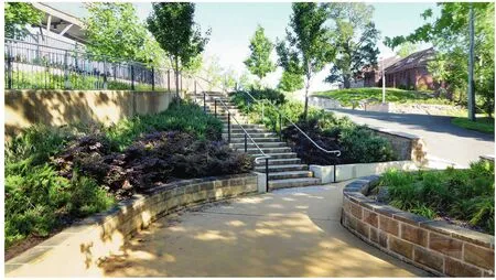
9 楼梯连接了公园内的台地与道路Stairs provide access between terraces & paths within Memory Park
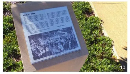
10 纪念公园内部的历史文化遗址解说牌Heritage interpretation panel in Memory Park
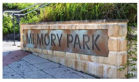
11 纪念公园的入口标识Entry sign to Memory Park
Restoration of Memory Park is making a significant contribution to a healthy,inclusive and robust Hazelbrook community by providing safe and convenient pedestrian and cycle connectivity through the park for residents and local school students linking to Hazelbrook village centre and railway station via the new pedestrian bridge over the highway.The park also provides emotional benefits for users though connection to nature and the opportunity to site and contemplate or socialise.
Memory Park now benefits the local economy by providing safe and convenient connectivity between Hazelbrook commercial centre,the railway station and adjoining residential areas.

