
A landscapem anagementanalysis framework and its prelim inary app lication in Ejina Oasis,Northwest China
2019-07-10 09:53:22YouHuaRanYanZhao
YouHua Ran,Yan Zhao
1.Key Laboratory ofRemote Sensing ofGansu Province,Heihe Remote Sensing Experimental Research Station,Northwest Institute ofEco-Environment and Resources,Chinese Academy of Sciences,Lanzhou,Gansu 730000,China
2.SchoolofEarth and EnvironmentalSciences,The University ofQueensland,Brisbane 4072,Australia
3.University ofChinese Academy of Sciences,Beijing 100049,China
ABSTRACT The implementation of integrated landscapemanagement to support localand regionalhuman well-being is crucial in arid regions,but itsapplication to date is very lim ited.A lthough analytical frameworks have been established tomaxim ize ecosystem services via trade-offs between different landscape configurations,consumption factors such aswater resourcesare rarely and weakly considered in such frameworks.In this paper,an improved integrated landscape-management analysis framework,called the Consumption-integrated Landscape Management to Ecosystem Service(CLMES),is proposed.In this framework,consumption factors are integrated at the same level as ecosystem services.The improved analytical framework is then used to assess and optim ize landscape design in the Ejina Oasis,an extremely arid region in western China.Three landscape conditions(past,current,and future)are evaluated,based on the CLMES.Our results indicate that the Heihe Riverwater-allocation program effectively promoted ecosystem services in the Ejina Oasis from 2000 to 2011.However,the excessive expansion of cropland led to a slight decline in habitatquality.An optim ized landscape configuration and policy suggestions are proposed,whichmay be beneficial to the improvementof totalwater-use efficiency,oasis stability,and resilience of the ecological-socialsystem in the Ejina Oasis.
Keywords:ecosystem services;arid region;water resources;land-use planning;remote sensing
1 Introduction
Humans benefit from ecosystems in amultitude of ways(De etal.,2002;Irw in etal.,2007).Mostmaterial resources and conditions necessary for human social and econom ic development and cultural life are provided by ecosystems(Ehrlich and Ehrlich,1981;Costanza et al.,1997;Daily,1997;M illennium Ecosystem Assessment,2005).The M illennium Ecosystem Assessment(MA)grouped ecosystem services into four broad categories:supporting,such as nutrient cycles and crop pollination;provisioning,such as the production of food and water;regulating,such as the control of climatic patterns and disease;and cultural,such as tourism and recreational benefits(M illennium Ecosystem Assessment,2005).
Humans tend to damage overall ecosystem services(in particular,provisioning services)to maxim ize local,short-term benefits by changing the land use,i.e.,landscape structures.Therefore,ecosystem services can be improved through landscape management and planning.Currently,ecosystem services are increasingly considered to be critical to resource-management decision-making based on a well-established analytical framework.In general,the framework includes four components that correspond to the following four steps:(1)landscape-scenario definition;(2)ecosystem-function analysis and mapping of the ecosystem services;(3)valuation of the ecosystem services;and(4)trade-off analysis(De 2006;Howe et al.,2014;Martín-López etal.,2014).A lthough the analytical framework for landscapemanagement iswell established,many barriers to the integration of ecosystem services into landscape-management practices remain(De Groot etal.,2010;Setten et al.,2012;Bieling et al.,2014).There are at least two aspects of these barriers.The first is that ecosystem services are not sufficiently considered in the respective analyses.For example,the cultural services of ecosystems are conventionally neglected due to the lim ited and challenging methods that can be used to quantify changing cultural services(Daniel etal.,2012;Plieninger et al.,2014,2015).Another issue is that the cost items,such as resource consumption and social influence,are often not given enough weight in the trade-off between different landscape configurations.A lthough cost-benefit analysis is well regarded in ecosystemservices-based land-use planning,it is usually considered in the final rather than in the function-analysis or function-valuation stage(De Groot,2006).The first possible reason for this approach is the theoretical and practical challenges involved in mapping resource consumption.These challenges hinder its application because resources are generally related to dynam ic and changing social values,which also have a complex interaction with the benefits of ecosystem services on different scales(Cash et al.,2006;Goldstein et al.,2012).Another potential reasonmay be thatpeople naturally pay excessive attention to the benefits and ignore the consumption of resources.
As a lim ited resource,water is very important for arid regions;but it is rarely considered in an integrated manner in ecosystem-services analyses.Three aspects of sustainable development(society,the economy,and the environment)are restricted by lim ited and typically fragile water resources.Scientific water-resourcemanagement lies at the core of sustainable development,especially in arid regions(United Nations World Water Assessment Programme,2015)such as the Hexi Corridor of China.As part of the Silk Road Econom ic Belt,the Hexi Corridor is a very important channel for the opening up of China to theWest.Limited water resources from precipitation and glacial runoff along the Qilian Mountains support the oasis ecosystem of the HexiCorridor.Themanagementand use of lim ited water resources in support of local and regional sustainable development and human well-being are thusa central issue.
The spatial and temporal dynam ics of water-resource consumption are strongly related to landscape configuration(Lüet al.,2014).However,due to the complexities of human-natural systems,the integration of ecosystem services into the landscape-management process is a critical issue in this field(Boumans etal.,2015).Despite the grow ing literature on ecosystem services,studies on integrated ecosystem services in cases of landscapemanagementare still lim ited,especially in developing countries(Fisher et al.,2014;Sitas et al.,2014).The objective of this study is to propose an improved analytical framework that emphasizes cost factors to support landscape-management decision-making and water-resources management to maxim ize net ecosystem services.The improved framework is then used to assess and optim ize the landscape design in the Ejina Oasis,an extremely arid region in northwestern China.
2 CLM ES framework
As mentioned above,although the analytical framework for the landscapemanagement of ecosystem services has been well established,the input factors in the framework have rarely been considered on an equal level with ecosystem services.Therefore,a new framework is needed to improve the practical planning and management of landscapes.In this work,a Consumption-integrated Landscape Management to Ecosystem Service(CLMES)analysis framework is proposed,as shown in Figure 1.Based on the commonly used scenario-based analytical framework,input factors such aswater,human resources,material consumption,and even social effects brought about by landscape changes are explicitly integrated into the CLMES framework.The first stage of the CLMES framework involves landscape configuration and scenario definition,which refer to policies,resource constraints,population grow th,and climate change.The second step involvesmapping the ecosystem services and the corresponding consumption from a biophysical model or consumption investigation.The"function-analysis"defined by De Groot(2006)is the basis of mapping the ecosystem services in this step.Its goal is to translate ecological complexity into a lim ited number of ecosystem functions that provide a range of ecosystem services(De Groot,2006).Mapping consumption allows for quantification of the spatial distribution of the resources input.The last step is the trade-off analysis,which can be implemented on either a value-basis or a physical-basis.The valuebased trade-off analysis requires an econom ic model to standardize ecosystem services and consumption.This approach should be preferred because it ismore likely to be accepted by stakeholders and landscape managers.However,ithas greater uncertainty in valuing current ecosystem services,as mentioned in the previous section.Thus,physical-based trade-off analysis can be used asan alternative one.
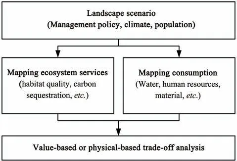
Figure 1 Consumption-integrated LandscapeManagement to Ecosystem Service(CLMES)analysis framework
3 A case study
In this section,we apply the CLMES framework to a case study of the Ejina Oasis,an arid region in western China.Three ecosystem services are considered:habitat quality,carbon sequestration,and sandfixing services.These services are vitally important in the arid regions of western China.Ecological water consumption is integrated into this analysis.Physicalbased trade-off analysis is considered,to discuss the optim ized landscape configuration.
3.1 Description of the Ejina Oasis
The Ejina Oasis is located north of the HexiCorridor and downstream from the Heihe River Basin between 100°58′E-101°21′E and 41°51′N-42°24′N(Figure 2),and it covers an area of approximately 1,800 km2.The Ejina Oasis is positioned atan altitude of approximately 900meters.The annualmean air temperature of the area is approximately 8.3°C.The extrememaximum air temperature of the area is 40°C and the extremem inimum air temperature is-37.6°C.The localmean annual precipitation levels reach approximately 42mm,and themean annual pan evaporation levels reach approximately 3,800 mm.The mean annualw ind speed is approximately 4.5m/s,with an annual maximum speed of 24 m/s(Han et al.,2011).The Ejina Oasis has a population of approximately 20,000.
The Ejina Oasis is surrounded by the GobiDesert,one of the fourmain sources of sand and dust in eastern China.Oasis vegetation plays an important role in w indbreak and sand-fixation patterns and in weakening sand dust storms.Thus,the Ejina Oasis is one of the fifty protected ecologicalareas of China(Fu etal.,2009).Themain soil texture in the area is sandy loam,with a thick soil layer and dom inant forms of vegetation that include shrubland(tamarisk)(5.77%),forest(Populus diversifolia)(6.22%),cropland(3.83%),and low-covered grassland(22.04%)(Figure 3b).Vegetation in the areamainly depends on Heihe water from the Qilian Mountains,but it is also heavily dependent on water in them iddle reaches,i.e.,Zhangye,where an irrigation system is now well-developed.Over the last twenty years,competition between Zhangye and Ejina for water has becomemore intense due to population grow th and the rapid econom ic developmentof the city of Zhangye(Jia etal.,2011).
To maintain the ecological functions of the Ejina Oasis,the Heihe River water-allocation program has been in operation since August2000.According to this program,the Zhangye City should discharge 0.95 billionm3ofwater to the lower reacheswhen the Yingluo Gorge,which forms the outletof the Heihe River from the Qilian Mountains,discharging 1.58 billion m3of water in normal years(Cheng et al.,2014).As a result,the ecological environment of the Ejina Oasis hasbeen restored.The East Juyan Lake coversamaximum area of approximately 42.8 km2.The average groundwater table has risen by 0.56 m(Niu et al.,2011).
3.2 Landscape configuration
Three landscape conditions were used in this study:the actual landscapes of the Ejina Oasis in 2000 and 2011 and a planning scenario.The historical landscapes were used to evaluate the effect of Heihe water allocation,which began in August 2000,as mentioned above.The planning scenario is designed to seek a better landscape configuration.
Land use in 2000(Figure 3a)represents the landscape prior to introduction of the Heihe water allocation,and land use in 2011(Figure 3b)represents the landscape after introduction of the Heihewater allocation.Based on the land-use conditions in 2011,landuse planning(Figure 3c)represents the future landscape configuration generated by changing land uses to reflect amanagement alternative.A comparison of the landscapes in 2000 and 2011 can be used to determ ine the efficacy of the Heihewater allocation,and a comparison of the landscape in 2011 with the planning landscape indicates that an optimal landscape configuration can be used to improve ecosystem servicesand conservewater resources.
Land use in 2000 and 2011 is represented by the actual landscapes of the study area,derived from Landsat TM/ETM imagery using the artificial interpretation method.The planning landscape was proposed by us based on comprehensive consideration of local econom ic development,im provement of the local people's quality of life,key ecological functions at the national level,and usable water resources.We assume thatwater resources from the central stream(i.e.,Zhangye)are constant.Some water from Juyan Lake was used to support grassland around the lake;and an artificial reservoir was built close to the Ejina Banner(a county town)to support tourism and leisure activities for urban residents,to supply water to natural ecosystems by regulating water flows,and to improve water-use efficiency levels.Furthermore,expanded cropland areas southeast of this area from 2000 to 2011 have been restored to shrubland,as shown in Figure 3c.

Figure 2 Location of the study area
3.3 Ecosystem-services modeling
InVEST,an open-source software model developed by Natural Capital Project at Stanford University(Nelson et al.,2009),was used to model habitat quality and carbon sequestration.The sand-fixing services were calculated based on the results of Han et al.(2011)by land-use type(6,603.5 t/km2for grassland,9,494 t/km2for shrubland,and 9,532 t/km2for forest)for the same area;and the sand-fixingmass per unitof areawas estimated using the sand-fixing function proposed by Dong(1998).
3.4 Ecological water-consumption m odel
Evapotranspiration(ET)levels are used to representecologicalwater consumption.An annual ET datasetwith a 1-km spatial resolution for the Heihe River Basin was derived from ETWatch,a remote-sensingbased evapotranspiration model,for use in this study(Wu et al.,2012).Based on these datasets,the annual ET for each land-use type for 2010 in the Ejina Oasis was obtained by Liu et al.(2015).The annual ET values for water bodies,cropland,natural vegetation(forest,shrubland,and grassland),barren land,and built-up areaswere 816mm,143mm,103mm,56mm,and 62 mm,respectively.These statistics were simply applied to the three landscape-configuration scenarios.

Figure 3 Landscape configuration(a)2000;(b)2011;and(c)future
4 Results and discussion
4.1 Optim ized landscape in the Ejina Oasis
The simulated ecosystem services and water-consumption levels in the Ejina Oasis(e.g.,habitatquality shown in Figure 4)show that different landscape configurations offer different ecosystem services at different levels of water consumption in this case.A lthough to some extentmore ecosystem services could be provided in 2011 than in 2000,water-consumption increases were more significant than ecosystem-services increases(Table 1).Even habitat-quality levels were not improved by changes in the landscape configuration from 2000 to 2011,despite an increase in water-resource-consumption levels of approximately 30%.The restoration of Juyan Lake greatly improved habitat-quality levels,but expanded cropland areas in the southeasthave detracted from this trend(Figure 4).Optim ized landscape configurations(i.e.,future scenarios)can improve ecosystem services while lim iting water consumption.As shown in Table 1,habitatquality,carbon sequestration,and sand-fixing services were all largely improved through changes in landscape configuration.The reduction in water consumptionwas significant.
Overall,the Heihewater-allocation program effectively promoted ecological restoration in the Ejina Oasis from 2000 to 2011.Ecosystem services improved sand-fixing and carbon-sequestration levels,with an increase in ecological water consumption(ET)levels from 2000 to 2011,although with a slight decrease in habitat quality due to the expansion of cropland(Table 1).However,the landscape configuration in 2011 was not optimal for maxim ization of ecosystem services and water-use efficiency.The planned land-use scenario effectively enhanced key ecosystem services in the Ejina Oasis while consum ing less water than under currentconditions.
4.2 Implications for landscape management
Based on the CLMES framework presented in this study,an optim ized landscape configuration was proposed for the Ejina Oasis.The promotion of ecosystem servicesmay be beneficialnotonly for localenvironments but also for the environment on a larger scale.For example,sand-fixing servicesmay be beneficial for most parts of eastern China(Yang et al.,2014).The case study may also enrich the application of ecosystem-services trade-offs in water-resourcesmanagement decision-making in arid regions,where their application is traditionally sparse(Seppelt et al.,2011;Cook and Spray,2012;Howe et al.,2014).These results also confirm the usefulness of the CLMES framework,and they provide a new perspective for the implementation of integrated water-resources management(Cook and Spray,2012).
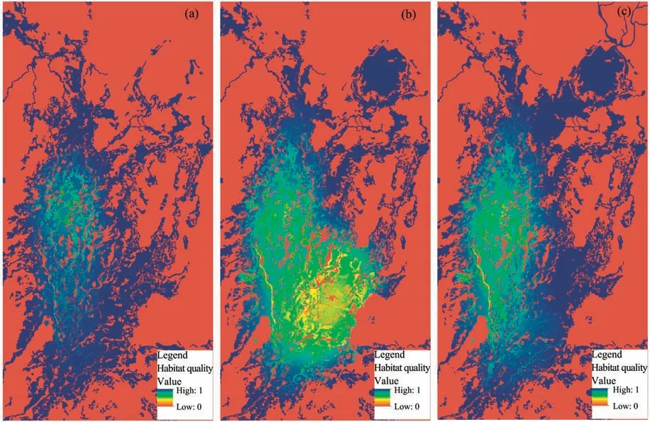
Figure 4 Distribution of habitatquality corresponding to the three landscape scenarios(a)2000;(b)2011;and(c)future
Specifically,the landscape configuration in Ejina Oasis should be optim ized to accommodate potential risk of water-resources reduction in the future and to increase the resilience of the ecological-social system.First,the cultivated land area should be reduced,especially in areas farther away from waterways.Second,from the perspective of increasing oasis stability,the area,species,and fraction cover of natural vegetation should be increased,which is beneficial for increasing habitat quality and biodiversity.Third,the connectivity among different ecosystems can be enhanced.For example,the vegetation corridors between Juyan Lake and the core oasis should be strengthened and broadened.A ll of these possibilities depend on effective water-resources management.The realization of the optim ized landscape needs technical and policy-level support.One of the technical approaches is reservoir construction.An artificial reservoir near the Ejina Banner is also suggested to support tourism and leisure activities for urban residents,to supply water to natural ecosystems by regulating water flows,and to improve water-use-efficiency levels.Groundwater and surface water should be managed together.The function of the groundwater reservoir should be restored against future water-resources risks.Fundamental policy approachesmay include increasing of the proportion of ecological industries,controlling totalpopulation,and building capacity.
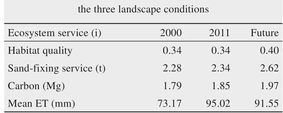
Table 1 Ecosystem servicesand water consumption under
4.3 Challenges for implementation of the CLMES framework
Due to the complexity of valuing resource consumption and ecosystem services,value-based analyses are not considered in this application of the CLMES framework in the Ejina Oasis.The physical-based analysismay be unattractive for local adm inistrations.However,the attractive aspects can be improved when comparing the beneficial effects of the planning condition with the effects of Heihewater allocation in the past.The prelim inary results indicate that the beneficial effects of Heihe water allocation can be partly achieved by adjusting the landscape configuration.
Although the valuation process is ignored in this study,wemust clearly understand the key challenges to the implementation of the CLMES framework.The most significant challenge is likely the approach to mapping and valuing resource consumption and its corresponding ecosystem services.Specifically,three likely aspects must be included.The first is valuing ecosystem services and consumption.In the CLMES framework,all inputs and benefits should generally be taken into account,including ecological,sociocultural,and econom ic values.These inputs and benefits may be calculated repeatedly due to themultiple functions of landscapes.The relevance of these functions generally shows temporal-spatial heterogeneity and is also closely related to the long-term evolution of people's values(Daily et al.,2000).The second aspect is the ubiquitous issue of scale.This issue is related to determ ination of the total benefits and different sectional interests of different stakeholders.Due to the different perceptions of benefits among different stakeholders at wide scales,their values are often inconsistent and dependent on each other(scale dependent)in practice.Therefore,when determ ining consumption inputs and ecosystem services,the stakeholders should be kept as consistent as possible.In this case,the input benefit is discussed only on a regional scale,and the optim ized landscape configuration ismeaningful on a regional scale for the public interest.However,itmay conflict with smaller-scale interests,such as reduced cropland for farmers.Nevertheless,such a loss could be compensated in the new opportunities or positions brought by new land-use patterns.The realization of such compensation would require skills training for the affected farmers.These interactions or conflicts among stakeholders at different scales are also related to the degree ofmarketization.Value and monetization are derived from econom ic theory and market theory(Gómez-Baggethun et al.,2010).The different degrees of marketization among stakeholders at different scales naturally produce inconsistencies.In practice,some markets are built only on a regional or national scale.Therefore,many measures,such as ecological compensation mechanisms and the building of water-and carbontradingmarkets,can be used to improve themarketization of certain elements of ecosystem services.Stakeholders at different scales have become gradually involved in trade-off analyses.The third aspect is the nexus and dynamic interactions among landscape characteristics,ecosystem services,inputs,and their values.These relationships are extremely complex and depend on the development of human-natural system models in the near future(Liu et al.,2007;Wagener et al.,2010).It is gratifying that the development of such an integratedmodelhasmade significantprogress.For example,Boumans etal.(2015)proposed aM ultiscale Integrated Model of Ecosystem Services(M IMES)analytical framework to assess the dynam ics of ecosystemservices functions and human activities.More substantial progress has beenmade in developing a watershed water-ecosystem-economy integrated model in the Heihe River Basin of western China(Cheng et al.,2014).However,the modeling of sociocultural-related inputs and benefits is still a challenge and requires further investigation.Spatial big data include geographical information from various sources and remote-sensing images,which have a promising future for the quantification of these sociocultural factors(Deville et al.,2014;Craw ford and Finn,2015).
Overall,system innovation and a series of scientific breakthroughs in several of the challengesmentioned above are needed both to improve the tradeoffs between the environment and development and to create a w in-w in situation that can generate substantial ecological,social,and econom ic benefits(De Groot et al.,2002;Howe et al.,2014).Until then,the proposed CLMES framework may be useful in practical landscape-planning and-management applications.
5 Summ ary and conclusions
An improved integrated landscape-management analysis framework,called the CLMES,is proposed to support landscape planning to maxim ize ecosystem services and deplete fewer resources.In this framework,consumption factors are integrated at the same levelasecosystem services.
A preliminary application in the Ejina Oasis,an extremely arid region of western China,indicates that CLMES can support landscape design that fosters human well-being in arid areas of China.Three landscape configurations were evaluated based on CLMES.The results indicate that the Heihe water-allocation program effectively promoted ecosystem services in the Ejina Oasis from 2000 to 2011.However,the excessive expansion of cropland led to a slight decline in habitat quality.An optim ized landscape configuration is proposed to improvewater-use efficiency.Our results indicate that Juyan Lake in the Ejina Oasis can be partially reduced to support the formation of more grassland and shrubland for sand-fixing services and urban resident recreation,while optim izing natural ecosystem water supplies by regulating water flows.Cropland area can be reduced to the levels in 2000 to improve habitat quality.An artificial reservoir close to the Ejina Banner can help support tourism and leisure activities for urban residents,supply water to natural ecosystems by regulating water flows,and improvewater-use efficiency.The function of the groundwater reservoir should be restored during the period of abundantwater through the cooperativemanagement of surface water and groundwater against the potentialwater-resources risks and restoring groundwater-dependent degraded ecosystems.Policy strategy such as increasing of the proportion of ecological industries,controlling total population,and capacity building are also fundamental.A ll of these factorsmay contribute to the stability of the oasis and the resilience of the ecological-social system.Several challenges,including the valuation of ecosystem services and resource consumption,issues of scale,and the landscape-ecosystem services-econom ic nexus,are also discussed.
Acknow ledgments:
This study was jointly supported by the National Natural Science Foundation of China projects(Grant No.41471359)and the Youth Innovation Promotion Association of the Chinese Academy of Sciences(Grant No.2016375).
 Sciences in Cold and Arid Regions2019年3期
- Sciences in Cold and Arid Regions的其它文章
- Vice p resident Zhang visited Cryosphere Research Station in A laska,Northwest Institute of Eco-Environment and Resource,Chinese Academ y of Sciences
- Risk prevention and controlstrategies for the severely affected areasof snow disaster in the Three Rivers Source Region(TRSR),China
- Stem radialgrow th indicate the optionsof species,topography and stand management for artificial forests in thewestern Loess Plateau,China
- MODISobserved snow cover variations in theAksu River Basin,Northwest China
- Assessing the im pactsof ecological-living-productive land changeson eco-environm entalquality in Xining City on Qinghai-Tibet Plateau,China
- Variation and relationship between soilm oisture and environm ental factors in the source region of the Yangtze River from 2005 to 2016