
A palaeoearthquake event and its age revealed by the travertine layer along the Litang fault in the southeastern margin of the Qinghai-Tibetan plateau
2023-11-08 02:22:50YoYngMingjinLingChoJunLiHulingShenFngDuSongLuoShoLiuXuelinRui
Earthquake Research Advances 2023年3期
Yo Yng ,Mingjin Ling ,Cho M* ,Jun Li ,Huling Shen ,Fng Du ,Song Luo,Sho Liu,Xuelin Rui
a Sichuan Earthquake Agency,Chengdu,610041,China
b College of Earth Sciences,Chengdu University of Technology,Chengdu,610059,China
c Zhejiang Earthquake Agency,Hangzhou,310013,China
d Chengdu Geological Survey Center,China Geological Survey,Chengdu,610081,China
Keywords:Travertine Paleoearthquake Soft-sediment deformation U-series dating Litang fault
ABSTRACT The Litang fault (LTF),located in the southeast of the Qinghai-Tibetan Plateau,is known for its high level of present-day seismicity,whereas its Pleistocene activity has been scarcely documented.This study focused on a tract of banded travertine deposits precipitated from thermal waters along the NW–SE-trending LTF trace.The role of travertine deposits in recording neotectonic activity has been studied by identifying their internal structure.Typical soft-sediment deformation structures observed within the banded travertines include micro folds,liquefied breccia,and liquefied diapirs.These deformed structures,which are restricted to a single unit separated unconformably by undeformed layers,can be traced for tens of meters,indicating that they were formed by seismic shaking triggered by LTF activity.The deformation of the banded travertine layers is attributed to the combined effects of seismic shaking,liquefaction,and fluidization,and it can be related to a paleo earthquake event with a magnitude of MS >5.The U-series ages obtained from the banded travertine deposits perturbed by the earthquakes are in the range of 130.59–112.94 ka,indicating an important fault-assisted neotectonic activity that occurred during the Middle–Late Pleistocene.Analysis of such structures,in combination with the use of U-series dating methods,can yield a reliable timing of neotectonic activity and provide new evidence for under-standing the seismotectonic setting of the Litang area.
1.Introduction
Travertines are calcareous,terrestrial deposits with hard and compact characteristics,mainly precipitate from thermal waters that are saturated or supersaturated with calcium carbonate (Ford and Pedley,1996;Hancock et al.,1999;Pedley et al.,2009;Wang et al.,2016).On the basis of the source from which the CO2can be derived,travertine can be divided into two classes: meteogene travertine whose carrier CO2is derived mainly from the soil and atmosphere,and thermogene travertine whose carrier CO2originates predominantly from thermal activity(Pentecost and Viles,1994;Pentecost,2005;Croci et al.,2016).Thermogene travertines distributed in active regions are neotectonic archives of the period in which they formed(Andrews and Brasier,2005;Temiz and Eikenberg,2011;De Filippis and Billi,2012;De Filippis et al.,2012;2013);thus,they are considered important sources of information for investigation of tectonic activity (Hancock et al.,1999;Brogi et al.,2018).
The fractures and cracks typifying the fault damage zone enhance the crust permeability and provide an efficient path for the migration and upwelling of geothermal fluids.Consequently,the thermal springs that are sources of travertines are generally aligned along some active extensional structures,e.g.,transtensional and normal faults (Hancock et al.,1999;Nelson et al.,2009;Selim and Yanik,2009;Pola et al.,2014;Smeraglia et al.,2020).The situation and morphology of travertine deposits can be strictly controlled by the kinematics of active faults (Martinez-Diaz and Hernandez-Enrile,2001;De Filippis and Billi,2012).Notably,microtectonic and mesotectonic structures can be used to detect neotectonic activity of faults (Martinez-Diaz and Hernandez-Enrile,2001;Brogi et al.,2018),and some of these small structures can be ascribed to paleoseismic events (Silva et al.,1997).Additionally,application of the U-series method offers considerable opportunity for accurate dating of travertine ages younger than 500 ka (Martinez-Diaz and Hernandez-Enrile,2001;Altunel and Karabacak,2005;Piper et al.,2007;Uysal et al.,2007;Mesci et al.,2008;Brogi et al.,2010;Temiz and Eikenberg,2011;Nishikawa et al.,2012).It can also provide a valuable contribution to the solution of tectonic problems because diagenetic deformation of travertines preserve important information on the chronology of tectonic activity (Uysal et al.,2009;Selim et al.,2016).For these reasons,interest in travertines has increased since the 1990s.In particular,the relationship between travertine deposits and neotectonic activity has been the subject of earlier studies that focused mainly on the morphology,macrostructure,geochemistry,petrography,and chronology of travertines,especially those of fissure-ridge travertine formations(Altunel and Hancock,1993;Uysal et al.,2007;Temiz and Eikenberg,2011;De Filippis et al.,2012;Nishikawa et al.,2012;Gao et al.,2013;Van Noten et al.,2013,2019;Pola et al.,2014;Shiraishi et al.,2020;Brogi et al.,2021).Nevertheless,the influence on the internal structures of travertine deposits related to seismicity has rarely been reported.The deformations of the internal structures caused by seismic activity are called “seismites,” a term initially proposed by Seilacher (1969).Such structures are mainly formed in unconsolidated sediments and are less frequently the result of brittle deformation (Gradzi′nski et al.,2014).Martinez-Diaz and Hernandez-Enrile (2001) described the structures(such as fractures,asymmetric folds,and micro unconformities) of travertines exposed on the Alhama de Murcia fault (Spain) and concluded that they are the result of tectonic activity.Gradzi′nski et al.(2014)unraveled the influence of seismic shocks on travertine mounds and pointed to the internal structures of the travertines as an imprinted record of paleoseismic activity.Brogi and Capezzuoli (2014) described the coseismic and postseismic effects of an earthquake event (M=3.6) on fluid flow and travertine deposition in a geothermal area of Tuscany(Italy).Subsequently,Brogi et al.(2018) reported on deformed earthquake-related soft-sediment deformations in travertine deposits located in southern Tuscany (Italy),and suggested that these seismites are evidence of an important seismic event that occurred between 84 and 48 ka.
In Chinese mainland,travertine deposits are widely exposed in tectonically active regions,such as the Huanglong travertines distributed near the Huya active fault (Liu et al.,1995;Wang et al.,2018),Kangding travertines exposed along the Xianshuihe active fault zone (Shi et al.,2014),Mounigou travertines deposited near the Songpan active fault(Shi et al.,2014),travertine deposits located in the northern Tianshan Mountains (Wang et al.,2020),Rongma travertines exposed in northern Tibet (Gao et al.,2013),Chusang travertine deposits emerged in southern Tibet (Wang et al.,2016),Baishuitai travertines exposed near the Jin-shajiang active fault (Yan et al.,2016),and Tengchong travertines located near the Nujiang active fault (Luo et al.,2021).Earlier studies on these travertines focused mainly on the influence of the climate and hydrology rather than on their morphology,isotopic characteristics,and chronology.In this study,for the first time,a comprehensive investiga-tion was performed on the travertines exposed in the Litang geothermal field in the southeast of the Tibetan Plateau.Travertines deformed by fault activity were identified during the fieldwork.The research objec-tives were to explicate and characterize the properties of the internal structures of the travertines related to neotectonic activity,and to investigate the paleoearthquakes of the Litang fault (LTF) based on age data of the travertine samples obtained using the U-series method.
2.Geological setting
The study area is located in the Litang Basin (China),which is a typical medium–high-temperature geothermal system in the Himalayan Geothermal Belt.Tectonically,it is situated in the southeastern margins of the Chinese Tibetan Plateau,which is the result of the tectonic collision be-tween the Indian Plate and the Asian Plate since 50–60 Ma (Fig.1),forming intensive structural deformations at high temperature and pressure (Tapponnier et al.,2001;Peltzer and Tapponnier,1988).The Litang Basin is a NW–SE-aligned depression with a width of 1–10 km,a length of 25 km,and an elevation of~4000 m above sea level.Active fault systems widely developed within the study area have a high level of seismicity (Fig.1).The LTF zone (LTFZ),Jinshajiang fault zone (JSFZ),Ganzi–Litang fault (GZ-LTF),Daocheng–Xiangcheng fault (DC-XCF),and Batang fault (BTF) are the major features of active tectonics within the area.The LTFZ is broadly parallel to the highly active Xianshuihe fault,and it extends from the JSFZ in the northwest to Litang and Dewu in the southeast.It has a total length of~190 km (Chevalier et al.,2016) and consists of four subordinate faults (from northwest to southeast): the Cuopu fault (F1),Maoya fault(F2),LTF (F3),and Dewu fault (F4).All the subordinate faults,except the Maoya fault with normal components,are characterized by left-lateral strike-slip with a reverse component on different segments,which is expressed by subsidence of the southwestern wall and elevation of the northeastern wall,and an average left-lateral slip rate of approximately 4 mm/a (Xu et al.,2005;Chevalier et al.,2016).The LTFZ is an intraplate active fault with a medium–low slip rate and low recurrence frequency of strong earthquakes.The largest known LTFZ earthquake(MS7.3) occurred in the southern section in 1948 and the most recent earthquake (MS5.1) occurred in 2016 (Fig.1;Xu et al.,2005;Zhou et al.,2015).Morphologic and tectonic evidence linked to the neotectonic activity of the LTFZ is well preserved,e.g.,offset geomorphic markers,fault scarps,shutter ridges,displaced channels and alluvial fans,beheaded gullies,and triangular facets.Moreover,a linear seismic surface rupture attributed to a large earthquake (MS71/2) in 1890 remains clearly visible in the northwest of the Litang Basin (Xu et al.,2005;Zhang et al.,2015).
The exposed strata (from oldest to newest) within the study area include Upper Triassic,Tertiary,and Quaternary (Fig.2).The Upper Triassic strata are most widespread and include the Tumugou Formation,Waduo Formation,Qugasi Formation,and Zhuwo Formation,which comprise mainly a set of flysch deposits with lithology of mainly metamorphic quartz sandstone,sand slate,limestone,and siliceous rock.Tertiary strata,which comprise conglomerate and glutenite of allu-vial–proluvial origin,are narrowly exposed on the eastern side of the western branch of the nearly NS-trending GZ-LTF (Fig.2).Quaternary sediments that consist of Pleistocene lacustrine sediments,Pleistocene alluvial sediments,Holocene alluvial sediments,and travertines are predominantly distributed in the Litang Basin (Fig.3;Long et al.,2006;Chevalier et al.,2016).
The studied travertines deposited from thermal springs are located in the northwestern part of the Litang Basin along the prominent lineament of the NW–SE-trending LTF,which lies at the intersection of the NW–SEtrending LTF and the nearly NS–trending GZ-LTF,approximately 3 km west of Litang County (Fig.2).The networks of intersecting structures enhanced crustal permeability and facilitated movement of the thermal fluid that resulted in the deposition of the spring-fed travertines.More than 10 thermal springs with temperatures in the range of 21–90°C are aligned along the trace of the LTF in the Litang geothermal field.The thermal water is characterized as Na–HCO3type (Long et al.,2006).One of the springs has been used for seismic precursor monitoring in recent years.
3.Methodology

Fig.1.Geological and tectonic map of the Litang area and its surroundings.(a) Topographic map of the Qinghai-Tibetan Plateau showing the location of Fig.1.(b)Tectonic map showing the active faults and historical earthquakes in the Litang area,and the location of the Litang travertines.LTFZ: Litang fault zone,XSHF:Xianshuihe fault,YLXF: Yulongxi fault,GZ-LTF: Ganzi–Litang fault,DG-XCF: Dege–Xiangcheng fault,JSJF: Jinshajiang fault.
A sampling of the banded travertines for U-series dating was conducted by us in March 2018.When sampling in the field,we selected relatively pure,dense travertine layers without recrystallization,thereby avoiding the introduction of detrital impurities and clay materials to ensure high-precision dating.To define the age of tectonic or seismic events,we sampled the marker layers of the banded travertines affected by earthquakes.As shown in Fig.4,the travertine layers used for U-series age determination analysis were divided into five microlayers: U1–U5.Layer U2 with a brown color was evidently strongly disturbed by earthquakes with obvious deformation shown as box-like folding.Layer U3 with alternating brown and off-white microlayers showed slight disturbance by earthquakes,evidenced as small gentle folds.Layers U4 and U5 represent undisturbed bedding overlying the deformed travertine layers,and layer U1 is the underlying undeformed layer.Using a chisel and hammer,four samples were carefully collected from layers U1–U4(labeled LT-01,LT-02,LT-03,and LT-04,respectively)for U-series dating analysis.
The U-series dating method was employed to constrain the age of neotectonic activity of the LTF.The method is based on the radioactive decay of nuclides within the238U,232Th,and235U decay series.U isotopes characterized by solubility and mobility can be easily leached from aquifers,migrate to the surface,and then be precipitated into CaCO3crystals in travertines (Ivanovich and Harmon,1983),whereas it is difficult for the radioactive daughter product230Th to be coprecipitated with CaCO3crystals because of its insolubility.However,230Th can be produced in travertine deposits by radioactive decay of234U following the initial formation of the travertine.Therefore,the230Th/234U activity ratio and the230Th/238U activity ratio,which can be assumed zero at the time of deposition during the formation of travertine crystals,increase with the prolongation of the precipitation time (Temiz et al.,2013).If travertines remain a closed geochemical system after precipitation,the radioactive disequilibrium in the238U–234U–230Th nuclides can be regarded as a chronometer with which to determine the age of travertine deposition(Cheng et al.,2013).Normally,samples with neither detritic impurities nor recrystallization can be considered a closed system(Martinez-Diaz and Hernandez-Enrile,2001).The index of the230Th/232Th ratio is used as an isotopic purity indicator of sample contamination (Luque and Julı‵a,2007).Samples for which the index value exceeds 17 are regarded as free of impurities.The230Th/232Th values measured in the samples obtained in this study were in the range of 6.98–71.49.Sample LT-01 yielded a230Th/232Th value of 6.98,indicating that impurities or inclusions might be present in the sample.The U-series dating analyses for the present study were performed at Nanjing Normal University (China).The U–Th chemical separation was undertaken in accordance with standard chemical procedures outlined in Shao et al.(2017).Subsequently,U and Th isotopic measurements were conducted using a Neptune MC-ICP-MS,similar to the method described by Shao et al.(2019).The U-series ages and age uncertainty were processed using Monte Carlo simulations (Shao et al.,2019).
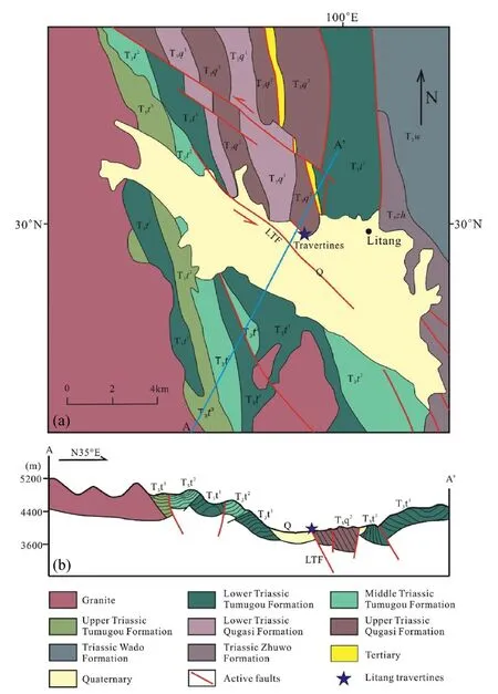
Fig.2.Geological map of the study area and surrounding regions.(a) Geological map of the study area showing the location of geological profile A–A′,modified after Long et al.(2006).(b) Geological profile A–A’.
4.Results
4.1. Travertine features
The Litang travertine deposits,which occupy an area of approximately 1 km2and hide a NW-trending fault belonging to the Litang active system,lie on Quaternary sediments exposed on the western bank slope of the Wuliang River in the northern margin of the Litang Basin.The morphotectonic feature is approximately 1600 m long,600 m wide,with a maximum height of 100 m,and it strikes N140°–145°(Fig.3),approximately parallel to the LTF.According to the morphological classification of travertine deposits proposed in previous research (Hancock et al.,1999),two typical types are recognized (Fig.5a): banded fissure-ridge travertines that straddle the central fissure (Fig.5b),and layered travertine mounds (Fig.5c) that begin from the margin of the banded travertines,which are related to the banded calcite veins associated with the fissure ridge developed within the travertines (Altunel and Hancock,1993).The fissure-ridge travertines give rise to asymmetric bodies up to approximately 200 m long,5–20 m wide,and 1–3 m high,with thicknesses ranging from a few centimeters to 150 cm.The central fissures have been closed,possibly because of the continuous filling of calcite veins attributable to ascending thermal fluids.The fissure-ridge travertines are characterized by crystalline onyx-like,millimeter–centimeter-thick,parallel and/or subparallel vertically banded layers that are oyster white to reddish-brownish in color (Fig.5b).The contact between rows within the color bands is usually marked by a color transition zone with variable thickness,and it is composed of microcrystalline and unequal calcite or opaque dark red material.These syntaxial banded travertines consist of dense and slender crystals that have grown from the walls toward the central fissure,almost perpendicular to the trace of the NW-trending fissure.Calcite crystals are present in three different types of structure:(1)a columnar/palisade structure composed of bladed,prismatic crystals(Fig.6a),(2)a radial fibrous structure made of fan-like splays of acicular crystals(Fig.6b),and(3)a crumb structure composed of a series of compact and nondirectional crystals with characteristic oyster white color(Fig.6c),representative of abiotic and rapid calcite mineralization by nearby active thermal springs.Usually,the bands are isopachous and the original layers are slightly wavy,which might reflect discharge by laminar–turbulent flows of thermal water.The lithology of fissure-ridge travertines is mainly composed of crystalline calcite with minor accumulations of clay distributed within cracks and fissures (Fig.6d).The layered travertine mounds consist of thin,horizontal,off-white,well-bedded,or laminated travertine and thick layers of crystalline calcite.While these internal morphologies might be well preserved,the surface of the travertine mounds is generally eroded and is characterized by a gray-black color (Fig.5c).The contact between the banded travertines and the layered travertines is blurred,and most of it has been replaced by alluvial sediments from gullies.
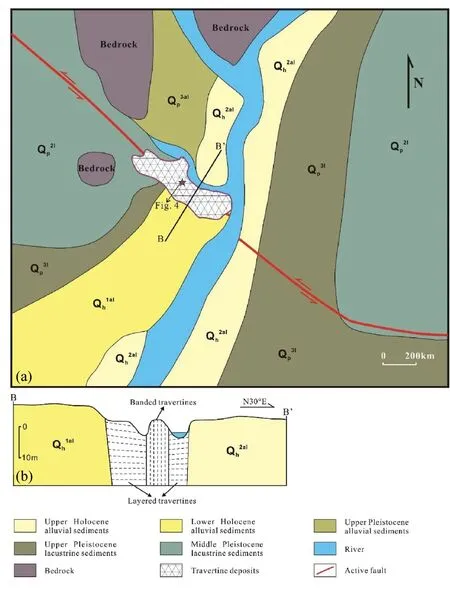
Fig.3.Quaternary geological map of the study area.(a) Quaternary geological map showing the location of the travertine deposits and location of geological–topographical profile B–B’.(b) Geological–topographical profile B–B’.
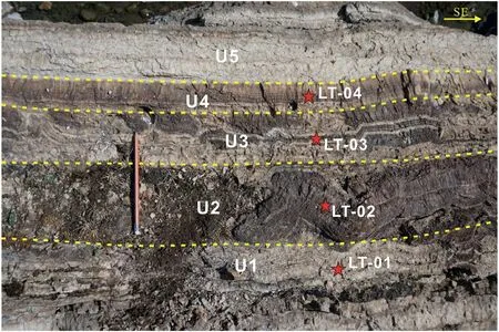
Fig.4.A typical section of banded travertines hosting the soft-sediment deformation structures.The photograph shows the units (U1–U5) with different deformation features and the locations of the samples taken for U-series dating (red pentagrams: LT-01 to LT-04).The location of Fig.4 is shown in Fig.5b.
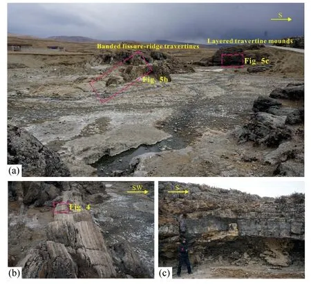
Fig.5.Field images of travertine deposits in the Litang area.(a) Panoramic view of the travertine deposits,(b) banded fissure-ridge travertines and (c)horizontal layered travertine mounds.
Petrographic analyses of the travertines deposited at Litang were performed using a polarizing microscope to detect their depositional facies along segments of the LTF (Fig.7).Microscopic analysis results revealed that the travertine is dominated by calcite with the characteristic of coarse giant crystals (size: 0.1–5.5 mm),most of which are >1 mm.Additionally,a small amount of clay is distributed within the cracks.The microscopic study results also enabled us to select travertine crystals free of detritic impurities for U-series age dating.
4.2.Soft-sediment deformation structures
The term seismic refers to redeposited layers of soft sediments disturbed by earthquakes (Seilacher,1969),and it has been widely applied to soft-sediment deformation structures,including micro folds(micro convoluted lamination),load structures,slump and collapse structures,water-escape structures,and synsedimentary microfractures,which result from modification induced by vibration,compaction,liquefaction,and fluidization (Du et al.,2001;Owen and Moretti,2011;He and Qiao,2015).Typically,three types of soft-sediment deformation structures (micro folds,liquefied breccia,and liquefied diapirs) are evident within the Litang banded travertine deposits.
4.2.1.Microfolds
A microfold (micro convoluted lamination) is a synsedimentary deformation structure formed by seismic waves acting on soft or unconsolidated sediment;if liquefaction occurs during the process of vibration,it is also referred to as liquefied convoluted lamination(Du et al.,2001;He and Qiao,2015).A microfold is a typical and common seismite structure that is mainly caused by the vibration and liquefaction of unconsolidated sediments with plasticity controlled by seismic activity to produce twisted and curled deformed bedding.A microfold is an intralayer deformation,the extent of which is limited to within the beds experiencing seismic disturbance.Owing to the small dimension and minimal directivity,a microfold differs from a structural fold in terms of its inconsistent and irregular configuration.
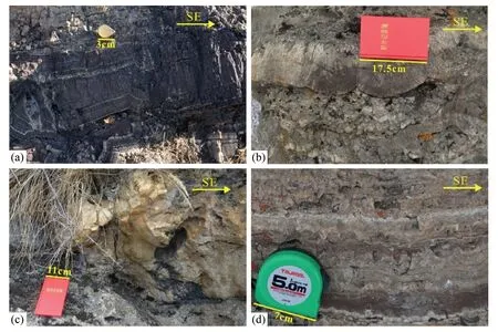
Fig.6.Structural features of the banded travertines.(a)Columnar structure composed of bladed,prismatic crystals,(b)radial fibrous structure made of fan-like splays of acicular crystals,(c) crumb structure composed of a series of compact and nondirectional crystals,and (d) crystalline calcite with minor accumulations of clay distributed in cracks and fissures.
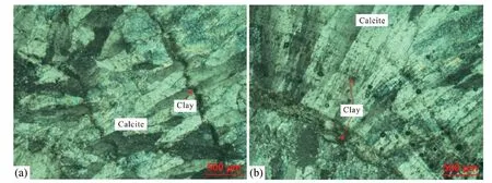
Fig.7.Thin-section photomicrographs of banded travertines showing mineral components.(a) Columnar calcite arranged in parallel,and (b) fan-shaped columnar calcite.
The micro folds in the studied deposits are centimeter-scale small folds that have different colors and thicknesses.The micro convoluted lamination does not cross into the upper and lower bedding and it generally has a thickness of 3–10 cm.The folds have different shapes and the fold axis can be upright and oblique.The length of a single buckle ranges from 1 to 10 cm,but is predominantly in the range of 1–5 cm.Micro convoluted lamination is characterized by small arcual folds,chevron folds,box folds,and flexures between the layers(Fig.8).These micro folds are different from folds that originate as post-sedimentary structures.The attitude of the fold axial planes as well as the fold vergence and facing are variable and uncoordinated in the two-dimensional saw cut,whereas folds affected by regional stresses are evident in all layers and are usually continuous and coordinated with large dimensions.In Fig.8a,the light brown layers with argillaceous material are characterized by small box folds and accompanied by seismic microfractures.In Fig.8b,the brown travertine layers are strongly deformed,resulting in the formation of arcual folds and chevron folds.In some places,collapsed spaces containing some argillaceous material are formed because of interlayer dislocation.In Figs.4,8c and 8d,the layers of brown travertine with mud interbedded with pure/off-white thin layers are manifested as liquefied convoluted lamination deformation that is the result of sediment particle movement controlled by earthquakes.
4.2.2.Liquefied breccia
Liquefied breccia is formed by earthquake-induced oscillation and cracking of unconsolidated depositional layers.When the pore fluid pressure exceeds the static pressure,sediments can experience strong liquefaction that induces travertine particles to penetrate into the underlying and overlying rock layers.These layers are destroyed,resulting in anisotropic and heterogeneous travertine fragments embedded within the sandy silt and migrated along the cracks.Liquefied breccias usually occur in terrigenous carbonate rocks and clastic rocks.In the study area,a typical example of liquefied breccia was recognized.The liquefaction breccia identified in Fig.9 is characterized by the feature that the overlying and underlying travertine layers are less disturbed rocks with relatively horizontal bedding.The breccia is mainly composed of muddy dark travertine,forming an irregular ellipse with a length of 3–5 cm and height of 2–3 cm,separated by off-white travertine veins in the middle,and the bedding plane of the protolith can still be identified as an entity(Fig.9a and b).The characteristics of the liquefied breccia identified in Fig.9b are similar to those shown in Fig.9a.The difference is that the overlying travertine layer still has clear horizontal layering,whereas the underlying thick brown travertine layers have been subjected to more severe disturbance but without liquefaction,resulting in arc-shaped folds.Because the brown travertine layer is generally formed in the rainy season,it contains a large amount of argillaceous material with high cohesion.The fact that water-saturated strata with certain amounts of argillaceous material are not liquefied or are difficult to liquefy under the effects of strong earthquakes (Zhao,2003),might explain why the underlying brown travertine layer was not liquefied.
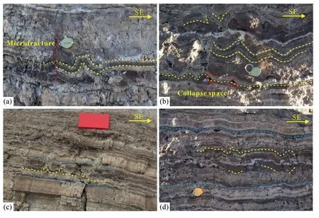
Fig.8.Photographs of microfold structures.(a)Arcual folds and chevron folds,(b)box fold accompanied by seismic microfractures,(c)and(d)liquefied convoluted lamination deformation interbedded with undeformed layers.
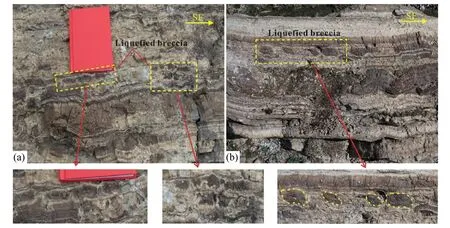
Fig.9.Photographs of liquefied breccia structures.(a) Breccias underlain and overlain by undeformed layers,and (b) breccias underlain by undeformed layer and overlain by deformed layer characterized by the development of microfold structures.
4.2.3.Liquefied diapirs
A liquefied diapir is formed by the intrusion of liquefied sediments upward into the overlying bedding,making a wedge-shaped anticline,because the upward fluid pressure is prominently greater than the weight of the travertine particles under the influence of strong vibration.A typical example of a liquefied diapir is found in the Litang banded travertine layers.As shown in Fig.10,travertine layers (approximately 5–10 cm thick) comprising alternating off-white and brown layers arch upward and pierce the overlying bedding,forming a narrow anticlinal fold that gradually transitions to the original horizontal bedding in the upward direction.Obvious cracks on the axial surfaces of the fold suggest that the travertine layers were compressed once liquefication ceased,thereby reducing the volume and resulting in fractures formed by shrinkage of the rock.
4.3.U-series dating
The results of the U-series dating of the samples collected from the banded travertine affected by fault activity or seismicity in Litang are presented in Table 1.The uncertainties of the U-series ages,U and Th concentrations,and U–Th activity ratios are given at the 2σ level.Reliable dating results were obtained for samples LT-02,LT-03,and LT-04 because the230Th/232Th activity ratios of these samples are >17,and the corrected ages are 133.31±1.60,130.59±1.82,and 112.94±2.80 ka,respectively.Sample LT-01 yielded an age of 122.26±4.94 ka,which was discounted because the low value of the230Th/232Th ratio (6.98)indicates that the sample might be contaminated or mixed with inclusions.Generally,the ages of the samples taken from U2 to U4 layers are in the range of 133.31–112.94 ka.
5.Discussion
The occurrence of travertine deposits,especially banded travertine,is closely related to tectonic structures (Hancock et al.,1999;Brogi et al.,2010).Active faults provide channels for the upward migration of hydrothermal fluids (Curewitz and Karson,1997) that are deposited as travertine on the surface.Thermogene travertine deposits can be used as fundamental records of tectonic events and earthquake occurrences owing to their geochemical characteristics and potential for U-series dating(Uysal et al.,2007,2009;Faccenna et al.,2008;De Filippis et al.,2013).Therefore,studying the architecture of travertine deposits in combination with the use of dating methods can provide important information on historic seismicity and the kinematics of active faults(Hancock et al.,1999;Piper et al.,2007;Uysal et al.,2007;Brogi et al.,2018).
The NW-striking LTFZ is an active left-lateral strike-slip fault crossing the Litang Basin,which starts from the JSFZ in the northwest and extends to Dewu in the southeast,with an overall length of approximately 190 km(Chevalier et al.,2016).The LTFZ is an important active fault system of the southeastern Tibetan Plateau(Xu et al.,2005),and it acts as a channel for the migration of the mantle fluids upward through the crust and to the surface,which plays an important role in seismic activity (Zhou et al.,2017).The travertines are deposited near the junction of two active faults belonging to the LTFZ,which is generally considered a stress-sensitive area.The tectonic activities of the LTFZ substantially affect the development of thermal springs and the accompanying travertine deposits.Earthquakes are triggered by fault activity,and the occurrence of strong seismic activity inevitably affects the physicochemical characteristics of travertine,resulting in changes to its facies and internal structures(Nishikawa et al.,2012;Gradzi′nski et al.,2014).
In this study,a set of deformed internal structures caused by earthquakes was observed in the banded travertines located in the Litang basin(Fig.4).The deformation structures attributed to seismic activity (also known as seismites) denoted as layers U2 and U3,are underlain and overlain unconformably by undeformed layers,i.e.,U1 and U4,respectively.This sandwich-like structure is often considered of seismic origin(Anand and Jain,1987;Cojan and Thiry,1992).The principal deformed section is approximately 30-cm thick and can be traced for tens of meters along the banded travertine.Characteristics typical of seismites such as microfolds,liquefied breccia,and liquefied diapirs are clearly identifiable.The deformed layers (U2 and U3) show different deformation characteristics.Layer U2 is characterized as a brown travertine layer with argillaceous material,and its deformation is the result of the combined effects of undulatory motion and shear stress resulting from the passage of seismic waves.Microfolds,as examples of intrabed deformation,are of irregular wavelength and different amplitude.Different from layer U2,layer U3 obviously experienced liquefaction processes,and is characterized by the development of liquefication products such as liquefied breccia and liquefied diapirs(Fig.9).In the liquefaction process,the high pore pressure of the fluidized travertine particles,caused by seismic shaking,forced the unconsolidated particles to penetrate into weak areas of the overlying strata.The liquefaction process did not affect layer U2,which might reflect the presence of a certain amount of argillaceous material that is difficult to liquefy(Zhao,2003).Deformations recorded from the banded travertine indicate that the internal structures of travertine deposits can reflect the kinematics of fault growth,and they provide strong evidence of important neotectonic activity in the Litang area.Owing to the absence of superposition of the deformed layers within the travertines,we deduced that the deformation structures were produced by a single triggering earthquake event.The size and type of these deformation structures reflect the influence of various factors such as the earthquake magnitude,epicentral distance,and sediment type(Allen,1986;Rodrìguez-Pascua et al.,2000).Several earlier studies considered the relationship between earthquake-induced deformation structures and earthquake magnitude.For example,Allen (1986) proposed a theoretical method for the characterization of the occurrence of seismites,earthquake magnitude,and epicentral distance at the basin scale.Atkinson (1984) and Audemard and De Santis (1991) both indicated that an earthquake with a magnitude of at leastMS5.0 is required to trigger the liquefaction process in the vicinity of the epicenter because earthquakes of lesser magnitude have insufficient duration to cause liquefaction.Galli(2000)reported that liquefaction can be produced by moderate–strong earthquakes and that 90%of cases occur within 50 km of the epicenter.Monecke et al.(2004) considered that disturbed and convolute structures are generated by earthquakes ofMS=5–5.5.Therefore,we deduced that the magnitude of the earthquake that produced the soft-deformation structures within the Litang banded travertines was ≥MS5.0.
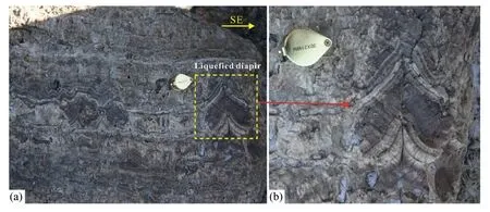
Fig.10.Photographs of liquefied diapir structures.(a) General view of liquefied diapir and convoluted lamination,and (b) detailed view of a diapir and the surrounding rock.

Table 1MC-ICPMS U-series dating results for the travertine samples.
Dating of syndepositional deformed layers triggered by seismicity helped us both determine the absolute age of the triggering earthquake and analyze the frequency and intensity of neotectonic activity (Allen and Banks,1972;He and Qiao,2015).According to our dating results,the ages of samples LT-01,LT-02,and LT-03,taken from travertine layers U2,U3,and U4,respectively,decreased successively,indicating that layer U2 was deposited earliest and layer U4 was deposited latest.The deformed layers (U2 and U3) affected by earthquakes were dated to approximately 133.31–130.59 ka.Thus,we can infer that the paleoearthquake occurred later than 130.59 ka because the travertine layers experienced synsedimentary deformation when the deposition was completed but not consolidated.The overlying undeformed layer yielded an age of 112.94 ka,which indicates that the deformed layers were perturbed by an earthquake event that occurred earlier than 112.94 ka.Our data led us to conclude that an important seismic event,which produced the seismites within the banded travertine,occurred between 130.59 and 112.94 ka,but that it was more likely closer to 130.59 ka because the time of the seismic event was close to the sedimentary age of the sediments.
The LTF is an active fault with a high level of present-day seismicity and it has the potential to breed strong earthquakes(Zhou et al.,2017).Nevertheless,the determination of historical or prehistorical seismic episodes cannot be achieved effectively owing to the difficulty in identifying paleoearthquakes that occurred before 1700.Previous research results indicate that three neotectonic movements occurred in Litang and the surrounding area(Wang,2004;Wang et al.,2004):the first started at 200 ka and ended at 120 ka,the second began at 50 ka and ended at 30 ka,and the third occurred at approximately 10 ka.The seismic event in the period 130.59–112.94 ka,evidenced by the deformed structures of the banded travertine,agrees with the proposed neotectonic movement in the interval 200–120 ka,occurring at the end of this period.This indicates that the LTFZ has been active since the Middle–Late Pleistocene,and such activity might have been accompanied by moderately–strong earthquakes.Our data documented from the deformed structures in the banded travertines provide valuable information on the seismotectonic setting of the Litang area in the southeastern Tibetan Plateau.
6.Conclusions
This study investigates the travertines deposited from thermal springs,which are located in the northwestern part of the Litang Basin along the prominent lineament of the NW–SE-trending LTF,focusing mainly on the internal deformation structures related to seismic activity.A series of earthquake-induced soft-sediment deformation structures,including microfolds,liquefied breccia,and liquefied diapirs,were recognized within the banded travertines,which coexist with each other and constitute soft-deformation structures considered typical of seismic origin.These structures can be interpreted as the result of the combined effects of seismic shaking,liquefaction,and fluidization triggered by a single seismic event ofMS>5.0.
The results of U-series dating of samples collected from the banded travertines perturbed by an earthquake event indicated that the earthquake occurred between 130.59 ka and 112.94 ka,and that it was more likely closer to 130.59 ka.This provides strong evidence of an important neotectonic activity during the Middle–Late Pleistocene in the Litang area,which was related to the activity of the LTFZ.These findings highlight the potential role of the internal structures of travertine in analyzing seismic episodes and tectonic activity.
Declaration of competing interest
The authors declare that they have no known competing financial interests or personal relationships that could have appeared to influence the work reported in this paper.
Author agreement and Acknowledgements
The authors declare that the work described was original research that has not been published previously and is not under consideration for publication elsewhere,in whole or in part.All the authors listed have approved the manuscript that is enclosed.This work is supported financially by Spark Program of Earthquake Sciences,China Earthquake Administration (XH202301Y and XH23048C),State Key Laboratory of Earthquake Dynamics,Institute of Geology,CEA (LED2020B02),Lhasa National Geophysical Observation and Research Station (NORSLS21-04),Earthquake Science and Technology Special Project of Sichuan Earthquake Agency(LY2205 and LY2206).
 Earthquake Research Advances2023年3期
- Earthquake Research Advances的其它文章
- Research progress in geophysical exploration of the Antarctic ice sheet
- Advances in experiments and numerical simulations on the effects of stress perturbations on fault slip
- Indian plate blocked by the thickened Eurasian crust in the middle of the continental collision zone of southern Tibet
- Influences of across-strike heterogeneous viscosity on the earthquake cycle in a three-dimensional strike-slip fault model
- Detailed sedimentary structure of the Mianning segment of the Anninghe fault zone revealed by H/V spectral ratio
- Freely accessible inventory and spatial distribution of large-scale landslides in Xianyang City,Shaanxi Province,China