
In-situ Lunar Penetrating Radar Experiments on the Moon of CE-3 and CE-4 Missions
2022-01-18 00:40:06XUYiZHANGLingLAIJialong
Aerospace China 2021年3期
XU Yi,ZHANG Ling,2,LAI Jialong
1 State Key Laboratory of Lunar and Planetary Sciences,Macau University of Science and Technology,Macau 999078
2 College of Geo-exploration Science and Technology,Jilin University,Changchun 130026
3 School of Science,Jiangxi University of Science and Technology,Ganzhou 341000
Abstract:China’s Chang’e 3 (CE-3) and Chang’e 4 (CE-3) missions made historic progress by sending rovers equipped with scientific instruments to the new sites on the nearside and farside of the moon,respectively.The same lunar penetrating radar (LPR) that uses pulses of electromagnetic energy to reveal the underground structure and properties of the lunar soil“regolith”covering most of the lunar surface was carried by the rovers.It provided for the first time the opportunity for in situ LPR measurements of the subsurface substrate in two geologically different places on the moon.At present,the Yutu rover of CE-3 mission traveled along a path of total length of about 114 m while the Yutu 2 rover of CE-4 has traversed over 1000 m and keeps going.This paper summarizes the fruitful results so far obtained by LPRs,including the physical properties and layered structure of the lunar regolith and shallow crust beneath the two landing sites.The regolith layer thickness at the CE-3 site is thinner than that at the CE-4 site due to its relatively young age.The penetration depth below CE-4 site is about 2.85 times (in terms of the forward and return path delay) deeper than CE-3 as indicated by their different loss tangent values (0.0039 ± 0.0002 vs.0.013),which is probably due to the differences in abundance of ilmenite and rocks in the regolith.Other physical parameters including dielectric permittivity vs.depth profile,bulk density and electrical conductivity have been estimated using various methods.Thanks to the low signal loss,CE-4 LPR is able to present clear cross section views of two buried craters and the paleo-surface(ancient surface) of the landing site.The multiple stratums observed by the low frequency channel of LPRs indicate several episodes of lava eruptions occurred in the late stage of the formation of the nearside Imbrium Basin and the farside Von Kármán crater despite the asymmetric volcanisms distributed on two sides.The discoveries revealed by LPRs advance our knowledges on the formation process and properties of lunar regolith,thickness of ejecta deposits caused by lunar impact events,the evolution of the nearside and farside volcanisms,etc.They also demonstrate the feasibility of applying ground penetrating radar for non-terrestrial explorations such as China’s first Martian mission,Tianwen 1 mission.
Key words:ground penetrating radar,Chang’e,moon,regolith,permittivity
1 INTRODUCTION
In December 2013,the Chang’e 3 (CE-3) spacecraft touched down on the northern Mare Imbrium of the lunar nearside (340.49°E,44.12°N).It was the first soft landing on the moon since the Soviet Union’s Luna 24 mission in 1976 and visited a new landing site.Later in January 2019,the Chang’e 4 (CE-4) spacecraft made a historic achievement by being the first probe soft landing on the lunar farside (177.588° E,45.457°S),in the Von Kármán crater on the floor of the South Pole-Aitken basin.The rovers of both missions were equipped with a dual-frequency ground penetrating radar,respectively (Lunar Penetrating Radar,LPR).
The first channel of LPR (CH-1) has antennas with a center frequency of 60 MHz and bandwidth of 41 MHz,which is mainly used to detect the geological structure of the upper,shallow crust.Its vertical resolution is 1 — 2 m in the mare basalt and can penetrate more than 100 m deep.The second channel(CH-2) contains high-frequency antennas with a center frequency of 500 MHz and bandwidth of 500 MHz,which is used to detect the thickness and structure of the lunar regolith layer.Its vertical resolution is 0.3 m in vacuum and can detect tens of meters deep.Compared to radar sounders onboard orbiting spacecraft such as Apollo 17 Lunar Sounder Experiment (ALSE),LPR can perform in-situ experiments with a much higher range resolution,thus offering a unique opportunity to survey in greater detail the shallow subsurface of both the lunar nearside and farside.
Based on the LPR data of CE-3 and CE-4 missions,scientists have successfully detected multiple subsurface lava layersand revealed the near-surface lunar regolith structure.The energy amplitude,the hyperbolic shaped signals caused by the diffraction of the buried boulders,and the reflection time differences extracted from the radar data were used to calculate the parameters of the regolith at the landing sites,including the dielectric constant,bulk density,electrical conductivity,and an estimate for the FeO+TiOfraction,etc.This paper aims to provide a review of the fruitful results obtained by LPRs so far.
2 CE-3 AND CE-4 LANDING SITES
The CE-3 probe landed in the Imbrium basin on the basalts inferred as Eratosthenian in age.These represent some of the youngest units on the moon at about 2.35 — 2.5 billion years (Gy) old compared with samples returned by the Apollo and Luna missions.The mafic components are TiO=4.0 wt% and FeO=20.7 wt% (data from the Active Particle X-ray Spectrometer (APXS) instruments on the CE-3 rover).The titanium dioxide abundance at the geological unit Im 1,~15 km to the north,is lower at~1.4 wt%,also suggested by the low albedo (see Figure 1(a)).
The CE-4 landing site located in the Von Kármán crater lying to the northwestern of the SPA basin,as shown in Figure 1(b),is the largest and oldest impact basin on the moon and may contain materials originating from deep in the crust or the upper mantle that would provide insights into early planetary differentiation.The Von Kármán crater formed in the pre-Nectarian era,was infilled with mare basalts during the Imbrian period.Subsequently,countless impact events both within and from outside the area infilled the crater with ejecta.Hence,the two landing sites vary greatly in terms of the surface age,geologic processes,and material compositions,etc.
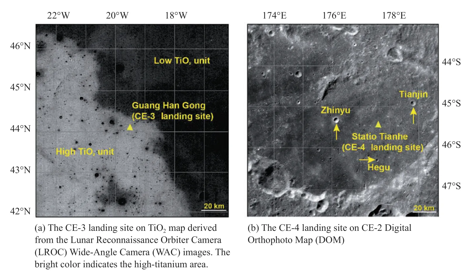
Figure 1 The landing sites of CE-3 and CE-4 [11]
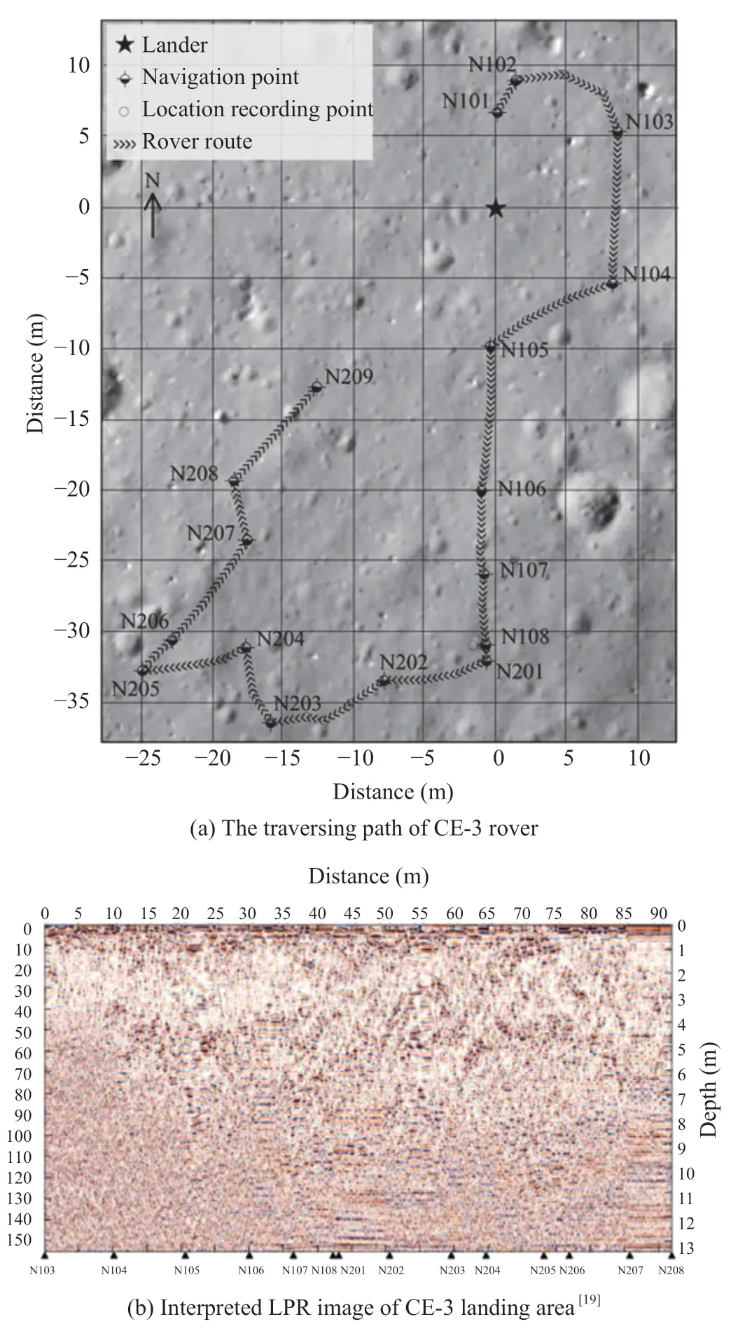
Figure 2 LPR results of the near-surface structure of CE-3 landing site
3 STRATIGRAPHICAL STRUCTURE
LPR data requires a series of processes before interpretation,including amplitude compensation,direct current removing,background removing,filtering.The processed LPR images are shown in the following sections.
3.1 Shallow Subsurface (Depth < 40 m)
CH-2 of LPR reveals the detailed near-surface structure.Figure 2 shows the scanning result under the exploration area of the Yutu rover.Roughly speaking,it contains three layers from top to the bottom:(1) the ejecta layer (at the depth of 2 — 6 m) of the~450 m sized crater that is~50 m away from CE-3 lander;(2)the paleo-regolith formed upon the Eratosthenian basalt layer (at the depth of~4 — 11 m);and (3) the bedrock layer.About 1 m thick weathering layer has developed on the top of ejecta deposits delivered from the CE-3 neighboring crater with an modeling age of~27 — 80 million years (My).The boundaries between different layers are not clearly displayed in the radargram due to high noise level caused by numerous scatters buried in the regolith.DING et al.found a cavity with height of~3 m in the ejecta layer of the nearby crater,suggesting that LPR is capable of detecting subsurface cavities such as lava tubes.Compared to the CE-3 landing site,the regolith layer at the CE-4 landing site is much thicker,~7 — 20 m as shown in Figure 3 as the surface age of CE-4 (~3.1 — 3.6 Ga) is much older than that of CE-3.Interestingly,the bottom of the regolith layer at the CE-4 landing site was also the ancient surface (paleo-surface) of the surveying area,which was indicated by the presence of two buried craters,meaning that most materials in the surface layer have been smashed,overturned,mixed,altered,and homogenized by the impacting and space weathering events during the period of 3.1 Ga.The first discovered paleo-crater is located along the track at a distance between 200 m and 350 m (blue rectangle in Figure 3(b)).It displays a bowlshaped outline with a width of 150±30 m and depth of 10±5 m and disrupts the continuity of the subsurface thin ejecta layers.The second one is still visible on the surface as a large circular depression as shown in Figure 3(a).Its size is 270 ± 10 m and the radial gradient of the slope is 29°.
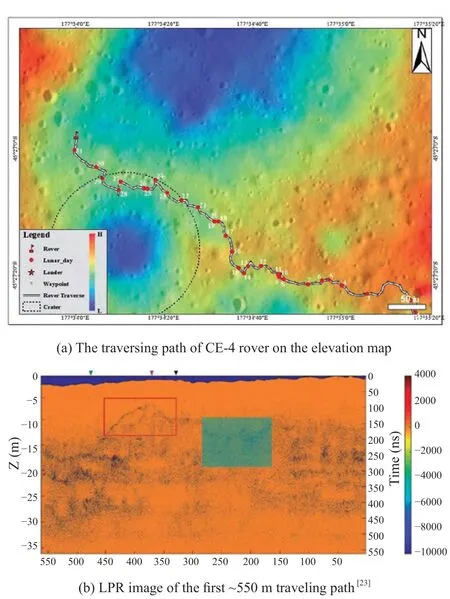
Figure 3 LPR results of the near-surface structure of CE-4 landing site
Beneath the thick regolith layer of the CE-4 landing site,well-defined reflectors in radar image (Figure 3(b)) have been interpreted as discrete depositional layers.Each layer went through a geologically brief time interval of weathering process.Clusters of rocks located at the bottom of each ejecta stratum are revealed,probably sorted by size due to the statistically less frequent occurrence of larger impact events admixing the deeper-seated materials.The horizontal reflector underlying the thin ejecta layers represents a paleo-regolith layer that developed on the surface of the exposed basalts.
3.2 Deep Subsurface (Depth ≥ 40 m)
The low frequency (CH-1) LPR data can be used to infer the relatively deep part of subsurface structure.CE-3 LPR detected more than nine subsurface layers indicating at least five distinct episodes of pyroclastic/lava filling events within the upper approximate 400 m depth .Although people argue that those reflectors obtained by CE-3 LPR CH-1 data might be system artifacts as ground experiments also observed reflectors at similar depth,a weak signal extracting method was proposed to avoid region with suspected system noises (Figure 4).Based on the interpreted stratigraphy structure,a 3-D geological model around CE-3 landing site was built to point the direction of the lava sources.An ultra-thick paleoregolith layer (~5 — 9 m)between the Eratosthenian unit and the Imbrian unit was identifiedon the migrated CH-1 radar image and its permittivity was confirmed from the reversed polarities of reflectors and forward modeling of LPR signals.
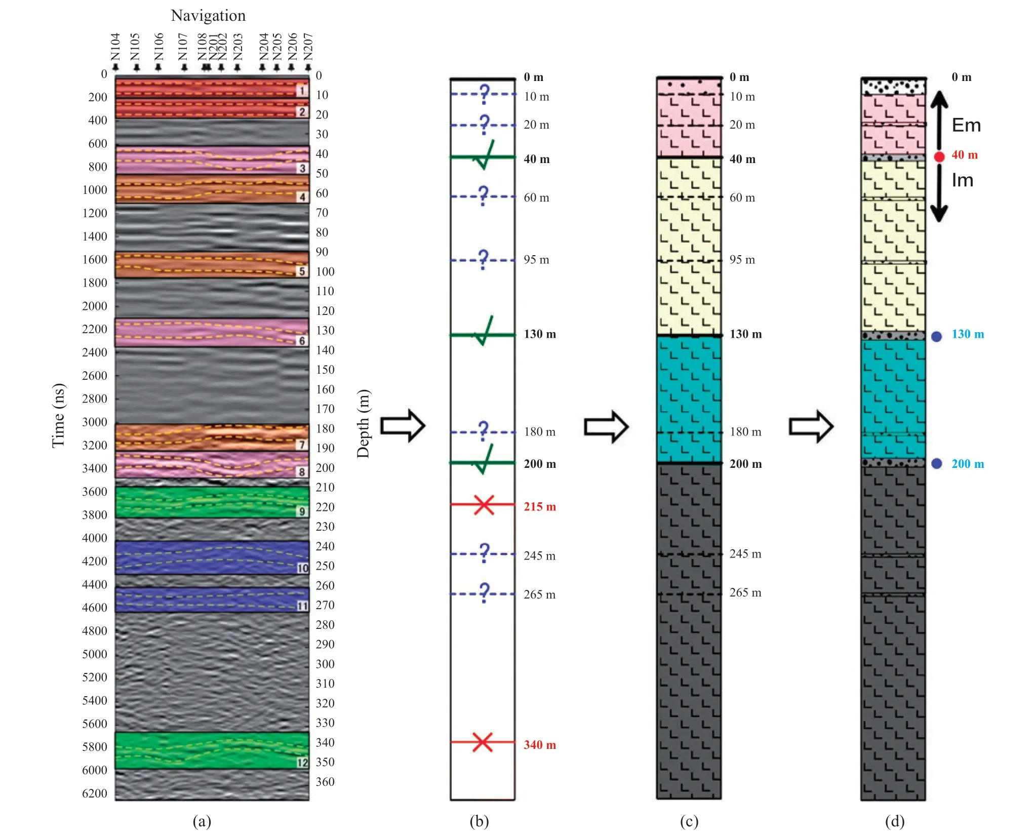
Figure 4 CE-3 CH-1 radar image [27]
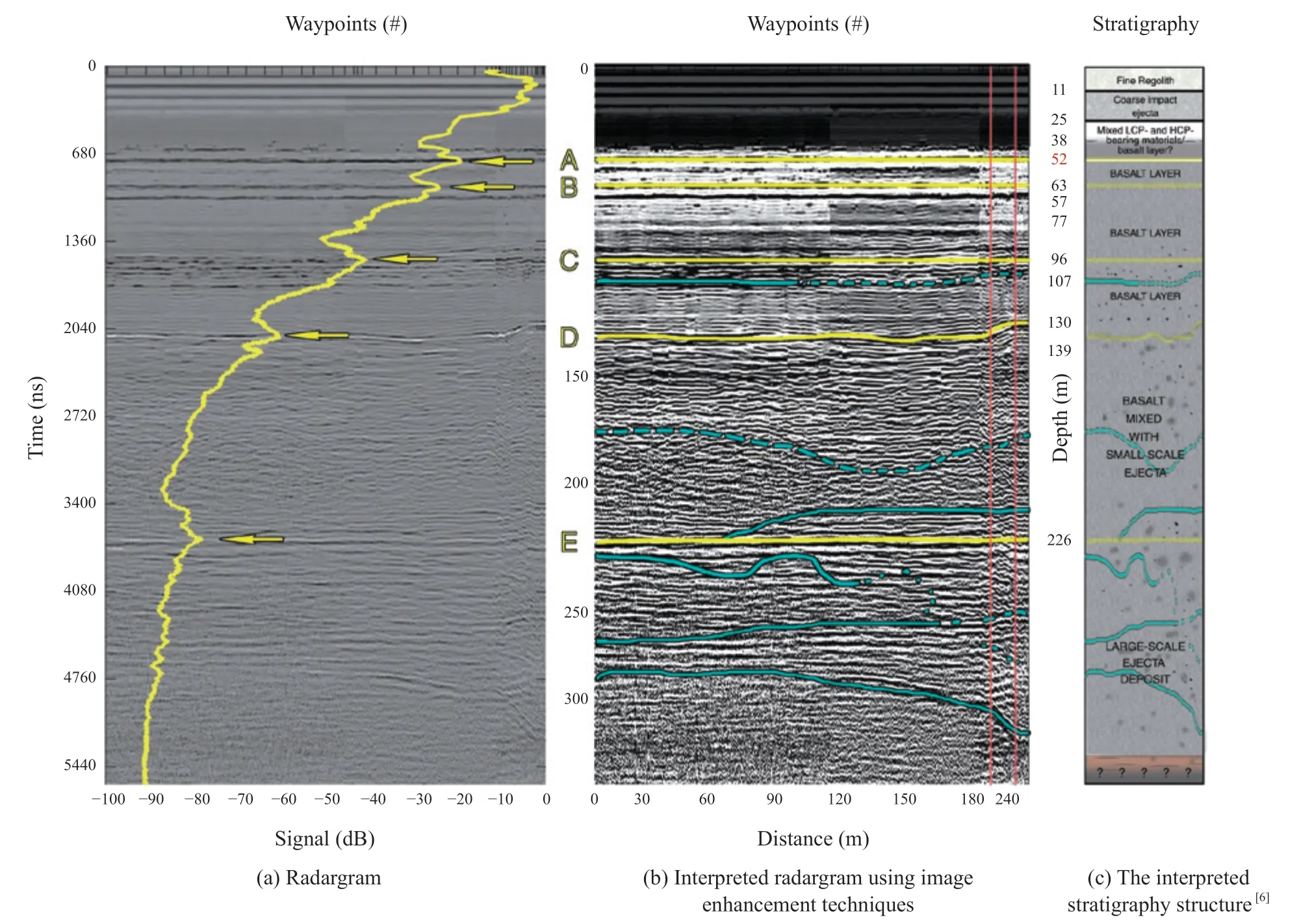
Figure 5 The CE-4 CH-1 radar image [6]
The radargram of the CE-4 landing site displays clear reflectors that can be separated from pitfallsand reveals several strata interfaces beneath the surveying path:buried ejecta is overlaid by at least four layers of distinct lava flows that probably occurred during the Imbrium Epoch,with thicknesses ranging from 12 m up to about 100 m,providing direct evidence of multiple lava-infilling events that occurred within the VK crater.However,ZHANG et al.provided a different interpretation by considering the surface 130 m thick layer as the ejecta and brecciated bedrocks,and the following 110 m thick layer as mare basalt.Pettinelli et al.raised doubts on the low frequency LPR data such as if a sequence of perfectly horizontal band in the first 2,000 ns is a real subsurface reflector or system noise and if the similarity between CE-3 and CE-4 data profile is caused by electromagnetic disturbances,etc.ZHANG et al.argued that the background removal and bandpass filtering processes could largely reduce the systematic noises.
4 DIELECTRIC PROPERTIES OF LUNAR REGOLITH
The loss tangent and the permittivity of the materials are important indicators for the composition of materials on the moon,which can be further used to speculate on the source of the substance beneath the traversing path of the rovers and acquire a better understanding of the geological structure and history around the landing sites.
The diffraction of the buried rocks results in the hyperbolic shaped signals in the radargram,which can be used to infer the permittivity values and the depth profile.At the CE-3 landing site,hyperbolae fitting method suggests that there might be two subsurface interfaces because of the dramatic change of permittivity value from~3 to~6(Figure 6(a)).The surface,subsurface reflections and the incident pulse amplitude can be used to obtain the relative dielectric constant of the lunar surface regolith,which is 2.9±0.4 corresponding to the bulk density of 1.63±0.19 (g/cm).The derived conductivity and FeO+TiOcontent of the lunar regolith are 0.0016±0.0006(S/m) and 26.4±3.4 wt%,respectively.The ilmenite content is consistent with estimations of the gamma ray spectrometer data onboard Lunar Prospector (TiO=5 ± 1 wt% and FeO=20± 2 wt%).
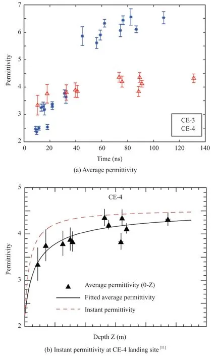
Figure 6 Permittivity vs.depth profile at CE-3 and CE-4 landing sites
At the CE-4 landing site,the permittivity and density of the subsurface fine regolith was also estimated with the hyperbola fitting method.The average permittivity value of the regolith layer is estimated to be~4.LAI et al.(2019) used signal loss to calculate the loss tangent of the fine-grained regolith layer,which is about 0.0039.LI et al.(2020) determined the average loss tangent of the fine-grained material under the CE-4 landing site to be (5±2)×10,based on the shifting of the centroid frequency with the depth.Using two empirical models,FeO+TiOcontent was estimated as 9 ± 4 wt% and 11 ±4 wt%,which are within the range of 11.4 to 15.9% obtained from Kaguya Multiband Imager (MI) data.DONG et al.(2021) utilized surface and subsurface pulse amplitude to infer the permittivity and density of the fine-grained regolith layer as 2.35±0.2.They also proposed a new empirical equation between permittivity and depth.The loss tangent value of the coarse materials beneath the lunar regolith at CE-4 landing site is~0.01,much higher than the overlying fine-grained regolith,indicating different sources.The comparisons of derived parameters at CE-3 site and CE-4 site via different approaches are summarized in Table 1.
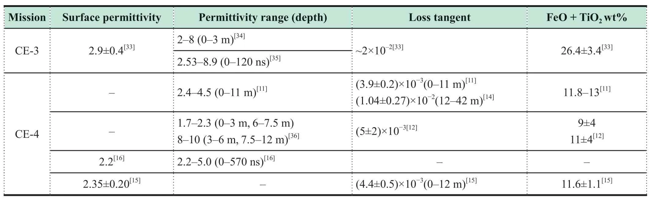
Table 1 Dielectric parameters derived from LPR datar
5 CONCLUSIONS
The similar LPRs equipped on the Yutu and Yutu 2 rovers provide a precious opportunity to reveal the shallow subsurface structure and substance properties at two sites on the nearside and farside of the moon,respectively.Based on the data of dual-frequency LPR,scientists have obtained the stratigraphy structure of the near-surface part and shallow crust,and derived physical parameters of lunar regolith including permittivity depth profile,surface permittivity,loss tangent,bulk density,electrical conductivity.The discoveries of LPR have advanced our understanding on important scientific questions regarding the lunar regolith formation speed,impact flux history,late-stage and farside volcanisms,etc.In addition,the lander of Chang’e 5 mission equipped with array-based ground penetrating radar (GPR),which helped obtain lunar samples successfully for the first time since 1972.The China’s first Martian mission Tianwen 1 will also employ GPR on the rover to search for subsurface water ice.In the future,we expect in-situ radar experiments will continue to be performed on lunar surface and terrestrial planets to investigate the subsurface structure and resources.

- Aerospace China的其它文章
- Artist’s Concept of Tianwen 1’s Brake and Captured by Mars
- Acoustic and Vibration Environment Prediction Technology of Instrument Cabin Based on Multi-Source Data
- Kinetic Laws of Heating Initiated Reactions for Materials in Aerospace Applications
- Design and Kinematics Analysis of Support Structure for Multi-Configuration Rigid-Flexible Coupled Modular Deployable Antenna
- Design of Optical System for Small Long-Life Star Sensor
- Principle Prototype of a Recovery Launch Vehicle with Vertical Take-Off and Landing