
Lessonsfrom construction and health condition evaluation of high-grade highway in permafrost regions
2021-12-29 03:14JianHongFangQingZhiWangKeJinWang
JianHong Fang ,QingZhi Wang ,KeJin Wang
1.Qinghai Research Institute of Transportation,Xining,Qinghai 810016,China
2.Qinghai Research and Observation Base,Key Laboratory of Highway Construction&Maintenance Technology in Permafrost Region,Ministry of Transport,Xining,Qinghai810016,China
3.School of Civil Engineering,Qinghai University,Xining,Qinghai810016,China
4.Qinghai Transportation Holding Group Co.LTD,Xining,Qinghai810016,China
ABSTRACT Located in the eastern margin of the Tibetan Plateau,the Gonghe-Yushu high-grade highway was the first of its kind in plateau permafrost regions.Most of the road sections along the high-grade highway are unstable or extremely unstable warm permafrost with an average annual ground temperature above−1°C,which is vulnerable to global warming and hu‐man engineering activities.This paper describes permafrost characteristics,roadbed design,and operation of the Gonghe-Yushu high-grade highway in detail.It is found that thaw settlement of warm and ice-rich permafrost is the main cause of subgrade subsidence in permafrost sections of this highway due to insufficient permafrost survey and drainage de‐sign.It is recommended that the interception and drainage system's design be optimized,and the permafrost upper limit and the variation of ground temperature be further investigated to provide essential data for the treatment of highway dis‐tress.It should be emphasized that protecting permafrost soil environment and optimized engineering design are crucial to successful high-grade highway engineering in permafrost regions.
Keywords:permafrost;high-grade highway;active cooling measure;distress
1 Construction of the Gonghe-Yushu high-grade highway
On April 14,2010,Yushu Prefecture,Qinghai Province,was struck by a 7.1-magnitude earth‐quake.To support the development of Tibetan areas and the reconstruction of Yushu,China had built a high-grade highway parallel to the Gonghe-Yushu section of National Highway 214.This is the first high-grade highway constructed in the Qinghai-Ti‐bet Plateau permafrost region(Feng,2014).After the Yushu earthquake,the State Council's General plan for recovery and reconstruction recommends to speed up the recovery and reconstruction of the trunk roads,improve the technical level and di‐saster resistance capacity of the national and provin‐cial trunk highways,construct one vertical,one horizontal,two connection lifeline road passage‐ways,and improve the construction grade and guar‐antee the passage of Xining to Yushu highway.The Gonghe-Yushu highway is not only one of the hori‐zontals of the eight verticals and eight horizontals in the western corridor per the Ministry of Communica‐tions and Transport's blueprint,but also an essential section of the golden tourist route in the Tibet areas of Western China provinces,including Qinghai,Tibet,Sichuan,and Yunnan.
As shown in Figure 1,The Gonghe-Yushu highgrade highway starts from the Chabucha Town,Gong‐he County,Hainan Tibetan Autonomous Prefecture,Qinghai Province,connecting with the Gonghe to Ca‐ka Highway from Beijing to Tibet High-grade highway(G6)under construction,and passing through three Ti‐betan autonomous prefectures,including Hainan,Guoluo and Yushu.Notably,its route traverses through Heka,Wenquan,Huashi Gorge,Maduo,Bayankala Mountain,Chalapin,Qingshui River,Zhenqin,and Xiewu,before ending in Jiegu Town(east of Xinzai),Yushu County,with a total length of 635.61 km.
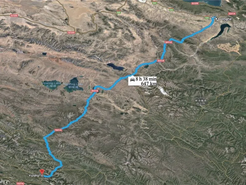
Figure 1 The route of the Gonghe-Yushu High-grade Highway(Map from Google)
The design speed limit of the Gonghe-Yushu highgrade highway is 80 km/h and drops to 60 km/h in the mountainous sections.The width of the separated sub‐grade is 10 m,and the total width of the highway sub‐grade is 21.5 m.The construction was divided into stages and sections.The first phase began in May 2011,the second phase in September 2013,and the entire highway opened to traffic in August 2017.The average elevation of the highway is above 4,100 m,with thin air and an oxygen pressure of only 60%that at sea level.The construction environment and condi‐tions are extremely poor,with cold air temperature and a large daily difference.It is windy and dry in all four seasons,with intense solar radiation and ultraviolet rays and hail and thunderstorms in the warm seasons.
Compared with the existing roadbeds in permafrost regions,the width of high-grade highway pavements in‐creases,and the heat absorption of asphalt pavement in‐creases exponentially.It has a more significant influ‐ence on permafrost extent and its thermal status,result‐ing in a greater potential of uneven settlement and de‐formation in the roadbed(Sheng,2002;Wu,2010;Luo,2012;Mu,2014).In addition,the technical stan‐dards of high-grade highways are more demanding,and the design service life is longer.This means that the construction of high-grade highways in the perma‐frost area of the Qinghai-Tibet Plateau is facing more complex and severe problems than the construction of Qinghai-Tibet Highway and Qinghai-Tibet Railway(Li,1998;Liu,2000;Liu,2013;Chen,2014).At pres‐ent,our country and even the whole world lack the technologies and experience to construct high-grade highways in the plateau permafrost region.The differ‐ence in pavement forms makes it difficult to directly apply existing research results of the Qinghai-Tibet Railway in high-grade highways.
According to the plan of the Transportation Depart‐ment of Qinghai Province,several high-grade highways will be constructed,including the ones from Yushu to Shiqu County in Sichuan Province and from Yushu to Changdu,which will traverse through permafrost re‐gions.With the acceleration of high-grade highway con‐struction in permafrost regions,it isurgent to set the stan‐dards for subgrade design and normal operation of the high-gradehighwaysin permafrost regions(Fang,2016).
2 Permafrost along the highway
The Gonghe-Yushu high-grade highway located on the eastern edge of the Qinghai-Tibet Plateau is a ma‐jor traffic route in Qinghai Province.Its overall path as‐sumes the NE-SW direction,spanning two degrees of latitude from south to north(33.5°N and 35.5°N).The highway crosses several main rivers in the region,in‐cluding the Yellow River,the Heihe river,the Longgen‐qu River,the Chaqu River,and the Tongtian River,and traverses through mountains such as the Heka Moun‐tain,the Erla Mountain,the Jianglu Mountain,the Changshitou Mountain,and the Bayankera Mountain.The elevation gradually increases from north to south to reach its highest point at Yakou(4,824 m)of Bayan‐kara Mountain,then descends slowly to Yushu.Accord‐ing to the survey data along the National Highway 214 and the construction of this high-grade highway,per‐mafrost is mainly developed in the high altitude section above 4,000 m,from the northern slope of the Ela Mountain to the Qingshui River Town.The mountains along the route tend to follow NW-SE direction,per‐pendicular to the highway.The highway longitudinal section shows the distribution of mountains and valleys interlaced with each other.Under the control of inter‐nal forces in plateau uplift,the different areas along the route are subjected to external forces such as flowing water,glacier,wind,and freeze-thaw.The topography and landforms are complex and diverse,including mountains,hills,valleys,intermountain basins,high plains,etc.,resulting in complicated permafrost condi‐tions and a difficult task to evaluate the thermal stabili‐ty of roadbedsalong this highway.
Among the 360 km of the highway crossing fro‐zen soil regions,227.77 km is in permafrost regions and 132.23 km seasonally frozen soils,as listed in Table 1.As shown in Table 2 and Figure 2,the cumulative length of ice-rich permafrost sections is 100.01 km,including subgrade section of 92.45 km and tunnel section of 7.56 km,and the total length of the ice-poor permafrost is 127.76 km.
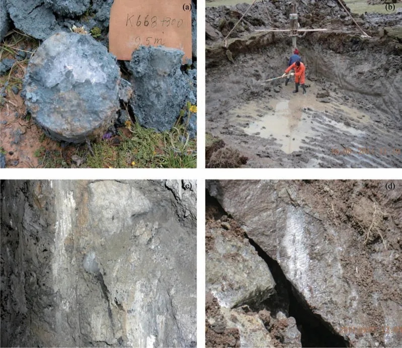
Figure 2 Challenging geological conditions of the Gonghe-Yushu high-grade highway.(a)Permafrost core near Bayankara Mountain;(b)Exposed ice-rich permafrost near Changshi Mountain;(c)Ice course in the surrounding rock of Jiangluling Tunnel;(d)Soil ice course exposed by foundation excavation near the Charaping Bridge
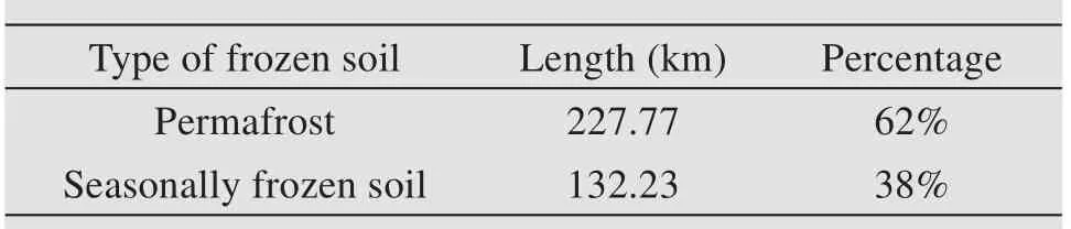
Table 1 Distribution of frozen soil along the Gonghe-Yushu high-grade highway
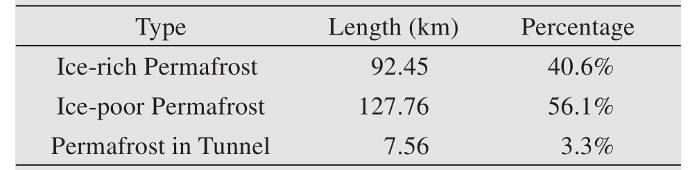
Table 2 Permafrost distribution along the Gonghe-Yushu high-grade highway
Permafrost temperature on the Eastern Qinghai-Tibet Plateau began to increase from 1982,with a warm‐ing rate of about 0.069℃/a.In the permafrost regions along the Gonghe-Yushu highway,the cli‐mate continues to warm,raising the ground tempera‐ture,thawing shallow permafrost,and lowering the permafrost table.There are also many challenging permafrost-related geological phenomena in this ar‐ea,posing a significant threat to the stability of the Gonghe-Yushu highway.The permafrost occurrences along the Gonghe-Yushu highway are dominated by warm unstable and warm extremely unstable perma‐frost,with poor thermal stability.Most of the perma‐frost sections along the route have high groundwater tables with abundant water grass and experience strong seasonal frost heave effects.The permafrost along the road is generally in the degradation stage under poor engineering geological conditions,as illustrated by the permafrost cores and excavation pit during site exploration in Figure 3.
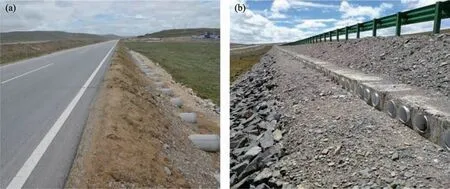
Figure 3 Examples of adopted embankment cooling measures along the Gonghe-Yushu high-grade highway
3 Design of subgrade
The design of the Gonghe-Yushe high-grade high‐way benefitted greatly from the lessons and experienc‐es learned from past road engineering in permafrost regions.For the permafrost sections with an annual mean ground temperature lower than−1.5°C or natu‐ral upper limit within 2 m of the ground surface and a thickness greater than 10 m,the design scheme was to preserve the permafrost.For the sections with low ice content,less than 5-m thick,and competent underly‐ing geological conditions,and for the sections with sporadic permafrost islands that are in a degraded state and for which thermal preservation measures are difficult to achieve results,the design philosophy was to control the thawing rate.
The engineering measures adopted for preserving permafrost include specially structured-subgrade with cooling or insulation devices(such as ventilation pipe,sheetrock,heat pipe,insulation board,etc.),fill‐ing or replacing with coarse granular soil,setting in‐tercepting drainage system,and so on.Specifically,a combination of cooling devices and insulation was often used for the specially structured subgrade,such as ventilation pipe and sheetrock,heat pipe and insula‐tion board,heat pipe and water-resistant insulation,and so on.
The main design measures for slowing perma‐frost thaw rate included controlling the elevation of subgrade filling,filling with coarse granular soil,soil retaining roadbeds,geotechnical materials,and adopting intercepting and drainage systems,etc.,For example,for the ice-rich sections,the insulated embankment was used when the subgrade height was less than 2.5 m.A total of 11 km of subgrade with XPS insulation was constructed along this highway.When the roadbed was taller than 2.5 m,the embankment with a 0.9−1.5 m thick layer of crushed rock ranging from 15 cm to 30 cm was ad‐opted.Most of the warm-temperature and ice-richpermafrost sections along the Gonghe-Yushu high‐way adopt crushed-rock embankment,with a total length of 72.0 km.A composite embankment with a combination of heat pipes and insulation was adopt‐ed for the section underlain by ice-rich permafrost.The XPS insulation board was laid at 30 cm below the pavement,and L-shaped heat pipes were in‐stalled at both sides of the shoulder.The heat pipes were laid at an interval of 4 along the route direc‐tion,with a total length of 4.8 km.It is worth noting that tunnels with a total length of 1,180 m in the Erla mountain and Jiangluling Ridge are located in ice-rich permafrost with a shallow cover.A threelayer lining system with heat insulation was adopt‐ed to ensure the tunnels'structural and thermal sta‐bility.Additionally,groups of heat pipes were in‐stalled in the shallow permafrost cover for active thermal protection.
4 Observed distress
Since the operation,there have been various de‐grees of subgrade subsidence and other distress in cer‐tain segments along the Gonghe-Yushu highway,as shown in Figure 4 including Zuima Beach,Changshi‐tou Mountain,Gobi Salt Beach,Chalaping,Bayanka‐ra Mountain,and Qingshui River.Thaw settlement of warm,ice-rich permafrost is the main cause of sub‐grade subsidence in the permafrost section of the Gonghe-Yushu highway.Through site inspection and comparison,the subgrade subsidence sections are mostly located in permafrost areas with ice wedges,rich segregation ice,and soil-bearing ice course.The settlement along the adjacent National highway 214 is also severe.
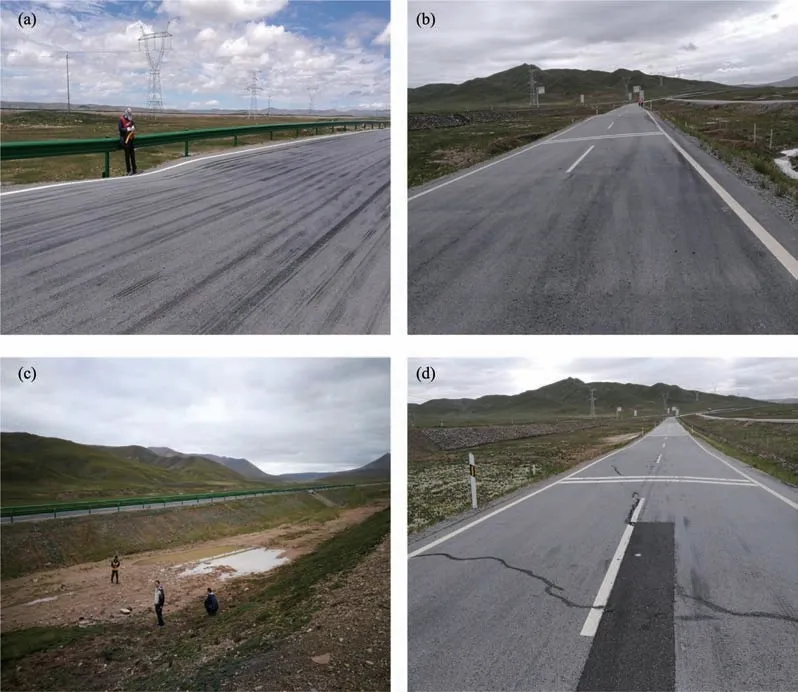
Figure 4 Distress observed along the Gonghe-Yushe high-grade highway.(a)Local subgrade settlement;(b)Differential subgrade settlement;(c)Water accumulation along the highway;(d)Longitudinal and transverse cracking in the pavement
The lack of experience in design,construction,and management leads to distress along the Gonghe-Yushu highway.Some specific issues are identified below:
(1)Insufficient permafrost survey in some sec‐tions of road.There was no necessary supplementary exploration for the sections with complex geological conditions,which resulted in the inaccurate assess‐ment of geological conditions and the types of perma‐frost soil,thus affecting the design.
(2)The subgrade drainage design was not ideal,or the drainage on both sides of the subgrade was not effective.Significant water accumulates at the embankment slope toe and side ditches of excavated subgrade sections.Infiltration of accumulated water in the drainage and intercepting ditches into the icerich subgrade permafrost leads to thaw collapses in the lower area of Bayankara Mountain and constant settlement.
(3)Both the construction and maintenance units are inexperienced in permafrost construction and man‐agement,and site management and control are not in place.Lack of coordination between culvert founda‐tion pit and roadbed excavation,reinforced side ditch lining construction,and embankment construction of‐ten resulted in long-time exposure of permafrost and thaw settlement in the subgrade and side ditch and other issues.
5 Standard for evaluating health conditions of subgrade of high-grade highway in permafrost regions
The intense thermal disturbance caused by climate warming and construction of high-grade highways re‐sults in a series of freeze-thaw related issues to the highway subgrade in permafrost regions,including the newly constructed Gonghe-Yushu high-grade highway.However,there was no unified standard for determining and evaluating the health conditions of high-grade highways in permafrost regions,which can truly reflect the service level of the highways.Thus,a health-condition evaluation system is estab‐lished to provide a scientific basis for the normal oper‐ation and daily maintenance of the high-grade high‐way.The evaluation system includes eight types of common highway distress in permafrost regions,in‐cluding subgrade frost heave and thawing settlement,subgrade slope collapse,subgrade structure damage,poor drainage,waterlogging gully,shoulder damage,and kerbstone damage.The details of damage-level definition,the calculation method of health condition index,detection and investigation of various distress,etc.,could be found in the local standards DT63/T 1886-2021(Fang,2021).
A subgrade health condition index,termed as PHSCI,can be evaluated based on subgrade condition detection and investigation according to JTG 5210,ac‐cording to the following equation:

where GDiPHSCIis the global damage deduction,wiis the weight assigned to a type of damage.PHSCI in‐dex ranges from 0 to 100.According to the values,the health status is divided into five grades:excellent,good,medium,inferior,and poor,according to the standards in Table 3.
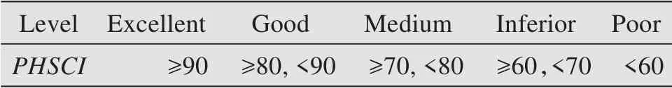
Table 3 Health conditions of the high-grade highway sub‐grade in permafrost regions
6 Summary
The construction of highways in permafrost re‐gions is still a challenging task.The stability of per‐mafrost is closely related to its surrounding environ‐ment.The design should take into account the temper‐ature,precipitation,other climate factors,and future trends.Placement of asphalt pavement for highways should be carried out after the completion of subgrade filling and two to three freeze-thaw cycles.
The existing drainage works in permafrost regions take various forms.Still,generally,there are problems such as poor durability,severe damage,poor drainage effect,and even the formation of catchment contain‐ers.Optimization of drainage ditch structures in permafrost regionsneeds further study.
Affected by the existing highway construction technology and complex permafrost conditions,some subgrade problems and pavement deformation have inevitably appeared since the operation of the Gonghe-Yushu high-grade highway.And the pro‐posed standard for evaluating the subgrade health condition will provide a scientific basis for the nor‐mal operation and daily maintenance of high-grade highways in permafrost regions.
Acknowledgments:
This work was supported by the National Natural Sci‐ence Foundation of China (Nos. 41801046,42161026),the Natural Science Foundation of Qing‐hai Province(No.2021-ZJ-716),and the Transporta‐tion Science and Technology Project of Qinghai Province(No.2019-06&No.2018-02).
 Sciences in Cold and Arid Regions2021年5期
- Sciences in Cold and Arid Regions的其它文章
- Review and prospect of the effectsof freeze-thaw on soil geotechnical properties
- Stabilizing subgradesof transport structures by injecting solidifying solutionsin cold regions
- Rationale for creation of capillary breaking layersin cold regions subgrade by pressure injection of waterproofing compounds
- Study on tensile damage characteristicsof sandstone under freeze-thaw cycles
- Numerical simulation of electroosmosis in unsaturated compacted clay
- Field monitoring of differential frost heave in widened highway subgrade