
Possible controlling factorsin the development of seasonal sand wedgeson the Ordos Plateau,North China
2021-05-31 08:09:18HughFrenchJefVandenbergheHuiJunJinRuiXiaHe
Hugh M.French ,Jef Vandenberghe,HuiJun Jin 3,,RuiXia He
1.Departments of Geography and Earth Sciences,University of Ottawa,Ontario,Canada,Department of Geography,University of Victoria,British Columbia,Canada
2.Institute of Earth Sciences,Vrije Universiteit Amsterdam,The Netherlands
3.School of Civil Engineering,Institute of Cold‐Regions Engineering,Science and Technology,Northeast‐China Observa‐tory and Research‐Station of Permafrost Geo‐Environment‐Ministry of Education,Northeast Forestry University,Harbin,Heilongjiang150040,China
4.State Key Laboratory of Frozen Soils Engineering and Northwest Institute of Eco‐Environment and Resources,Chinese Academy of Sciences,Lanzhou,Gansu 730000,China
ABSTRACT Wedge‐like structures filled with silty sand penetrate Quaternary fluvial and aeolian sediments and,in places,Tertiary bed‐rock on the Ordos Plateau,North China.The wedges reflect thermal contraction cracking of either permafrost or seasonal frost during the Late Pleistocene and early Holocene.Wedges of about 1 m in depth form polygonal nets of 2−3 m in diameter(type B).They contrast with wedges of 3−4 m in depth that form polygons of 10−15 m in diameter(type A).This review focuses upon the highly variable size of the inferred polygon nets and discusses the problem of differentiating between seasonally and perennially frozen ground,or between seasonal frost and permafrost.
Keywords:frozen ground;sand‐wedge casts;frost fissures;thermal contraction cracking;seasonal frost cracking;desiccation cracking
Preface
This paper was originally conceived by Hugh French in reviewing the often complex and controver‐sial origins of sand wedges and fissures.Ultimately,Hugh was not capable of finishing the revision of the original manuscript himself.However,the issue is highly relevant and fundamental to paleo‐climatic and‐environmental reconstructions.The co‐authors feel that the paper fully typifies both Hugh's profound knowledge in geocryology and in the periglacial envi‐ronment and processes and his provocative thinking in paleo‐reconstruction.Thus,they tried to credit Hugh's original opinions while not avoiding the many caveats that must be considered in this topic.The co‐authors will take responsibility for any comment on the paper.As such,it is thought that the paper high‐lights Hugh's inspiring significance for paleo‐perma‐frost research.At the end of the article,a brief summa‐ry of Hugh's contribution to the periglacial environ‐ment and permafrost sciences is presented.
1 Introduction
Ⅰn general,cracking occurs when the internal strength of a material is exceeded by an external stress(Lachenbruch,1962;Price and Cosgrove,1990;Hales and Roering,2007;Péronet al.,2009a,2009b).This can be caused in soils by,amongst other mecha‐nisms,declining temperature or progressive desicca‐tion,or both(Leffingwell,1915;Washburn,1956;Péwé,1959;Kerfoot,1972;Yershov,1990;French,2018;Bordoloiet al.,2020).Cracking by declining temperature can only happen in solid material,for instance,either frozen soil or rock.With regard to paleo‐temperature reconstructions,it is obvious that it is of primordial importance to define the former mecha‐nism(desiccation or thermal contraction)and condi‐tions(perennial or seasonal frost in case of thermal contraction)(Meyeret al.,2015).This is especially rel‐evant to the paleoclimatic reconstruction of northern China since many researchers reported the existence of thermal contraction cracks for inferring former perma‐frost(e.g.,Yanget al.,1983;Donget al.,1985;Cuiet al.,2004;Jinet al.,2007,2016,2019,2020;Zhaoet al.,2014;Heet al.,2020).Here,we re‐consider obser‐vations upon the size of sand wedges and the associat‐ed polygonal network dimensions,as seen in roadside exposures and gravel pits on the Ordos Plateau largely described before(Cui and Xie,1984;Vandenbergheet al.,2004,2019,2020).Based on this review,it aims to initiate a discussion on the origins of the different kinds of sand wedgesand their frozen‐ground significance.
There is a fundamental difference between"sand‐wedges"and"sand‐fissures(veins)".Ⅰn princi‐ple,they differ by their original formation conditions:sand fissures develop as single contraction events in seasonally frozen ground,while wedges develop by multiple contraction events in perennially frozen sub‐stratum.As a result,their outlooks(dimensions)dif‐fer:fissures(=cracks,veins)are narrow and usually ex‐tend no deeper than about 1 m,while wedges are gener‐ally wider than 15 cm(but often much wider,e.g.,Berg and Black,1966;Péwé,1966;Murtonet al.,2000;Van‐denbergheet al.,2004,2019,2020;Heet al.,2020)at their top and may extend down to several meters.From a genetic point of view,cracks form as a result of single contraction events after which the opening is closed.Ⅰn contrast,wedges are formed by successive,multiple cracking events and filling of the split with allochthonous(mostly aeolian)sediment after each splitting event.
Ⅰt is traditionally thought that sand wedges are ap‐propriate environmental indicators.Based on present‐day analogues,they were supposed to form in semi‐ar‐id and cold conditions(e.g.,Berg and Black,1966;Péwé,1966;Black,1976;Romanovskii,1977,1985;Murtonet al.,2000;Murton and Kolstrup,2003).As such,they were used as reliable and significant prox‐ies in paleoclimatic reconstructions(e.g.,Karte,1979;Vandenberghe,1983;Vandenbergheet al.,2004).Of‐ten used as proofs for permafrost conditions,this in‐terpretation was challenged by their potential occur‐rence on local,not perennially frozen,vegetation‐free and snow‐free surfaces,already by Jahn(1975)and Fisher(1996)and confirmed by Bertranet al.(2014),Andrieuxet al.(2016)and Wolfeet al.(2018).
Occasionally,thermal contractions can result in frost‐cracking fissures,such as during severe cold spells and resultant intense seasonal frost,but there is no indication at all for a perennially frozen ground(French,2018).That is to say,it cannot be used for in‐dicating the occurrence of permafrost.Ⅰn addition,fis‐sures(or veins)have often been reported from a clayey‐silty substrate(e.g.,Péronet al.,2009a,2009b).Ⅰn the latter cases,the origin of cracks may also be attributed to desiccation of the substrate in which they developed instead of thermal contraction(e.g.,Vandenbergheet al.,2004).The latter cracks are not further discussed.
Ⅰn this paper,we highlight the important difference between seasonally‐and perennially‐frozen ground for sand‐wedge formation.Ⅰn seasonally‐frozen ground,the thermally‐induced split does not extend deeper than the depth of seasonal frost;in contrast,in perennially‐frozen ground,thermal stresses may extend to greater depths and thus the related splits may be deeper(French,2007,2018;Wolfeet al.,2018).Ⅰn general,the horizontal stress relieved by material splitting is proportional to the depth of the split(Shiet al.,2014;Milleret al.,2015).As a result,deeper cracks/wedges occur farther apart while smaller cracks and wedges are more closely spaced.This principle is of course val‐id for both thermal and desiccation contraction(Milleret al.,2015;Yinet al.,2016).Obviously,the distance between splits is also a function of the soil/rock proper‐ties because different materials have different hydra‐tion properties.The coefficients of thermal expansion vary according to the nature of the involved mineral(Hales and Roering,2007;Wang and Zhou,2018).For example,the absence of clay from sandy and gravelly sediments makes desiccation cracking in such material less likely(e.g.,Molet al.,1993).Finally,cracks of small dimensions may be formed by subdivision of pre‐vious,primary large polygons to further reduce origi‐nal stresses(e.g.,Luschet al.,2009).
Ⅰn recent years,continued construction,such as road building and city expansion activities,in the vi‐cinity of the city of Dongsheng(now Dongsheng Dis‐trict of the Ordos City),Ⅰnner Mongolia Autonomous Region(ⅠMAR),China,has created new opportuni‐ties to further examine the different kinds of wedges and fissures in recently exposed walls or roadcuts.Fieldwork was undertaken in June 2015 and June 2018(Vandenbergheet al.,2019;Heet al.,2020)as a follow‐up to previous research(Vandenbergheet al.,2004). The Optically Stimulated Luminescence(OSL)‐ages used in this paper were obtained on fine sand‐sized(90−150µm)quartz grains using conven‐tional preparation procedures at Nanjing University(details described in Vandenbergheet al.,2019).
2 The Ordos Plateau
The Ordos Plateau(OP)is located between lati‐tudes 38°N−39°N and north of the Loess Plateau of North‐Central China(Figure 1).Surrounded by the Yellow River in the west,north and east,the OP is located in the southwest‐centralⅠMAR,China,on the southernⅠnner Mongolia Plateau.Ⅰt is a desert‐steppe region with the substratum consisting of Me‐sozoic‐Cenozoic terrigenous clastic sediments(Van‐denbergheet al.,2019).The OPgently slopes south‐eastward over about 130,000 km2at 1,000−1,500 m a.s.l..The eastern OP consists of alternating hills and valleys,and the western OP,sand dunes.The northern and southern parts are the Kubuqi(Hobq)and Mu Us deserts,respectively.The central OP comprises undulating hilly deserts.On the northern margin of the OP,the Hetao Plain extends along the Yellow River valley.
The Salawusu River Basin on the southern OP is at the edge of the monsoonal climate zone and in a transition zone among several deserts and the Loess Plateau in North China.The OPhas a typical temper‐ate continental climate at present,with mean annual air temperatures(MAATs)of approximately 5.5 to 6°C.Based on the data from 1961−2016,the coldest monthly mean air temperature(January)is−13 to−10°C,and the hottest(July)is approximately 21 to 25°C.The daily and annual ranges of air temperature are 11−15°C and 45−50°C,respectively.The precipita‐tion in the eastern part is 300−400 mm,and that in the western part is 190−350 mm.The precipitation is con‐centrated in summer from July to September,and the annual evaporation is 2,000−3,000 mm(National Cli‐mate Center of China Meteorological Administration)(http://cdc.cma.gov.cn/home.do)(Heet al.,2020).
After several uplifts during the Miocene,these sediments were eroded and leveled,resulting in a pla‐nation surface aged at ca.3.7 Ma B.P..(Panet al.,2010),which dips gently eastward and northward from 1,500 to 1,000 m a.s.l.(Yueet al.,2007;Vanden‐bergheet al.,2020).During the Pliocene‐Pleistocene and subsequently,the Yellow River and its tributaries have become incised within the OP(Panet al.,2010).The lacustrine sediments of the Salawusu Group,rich in mammalian and ancient human fossils,were depos‐ited during the Late Pleistocene(Yan,1982;Liet al.,2000,2004).Therefore,the OPis one of the appropri‐ate regions for investigating the environmental chang‐es and permafrost evolution during and after the Late Pleistocene.Sand wedges occur in the near‐surface sediments of the cold deserts of Central Asia and West China(e.g.,Owenet al.,1998;Wanget al.,2003;Vandenbergheet al.,2020).On the OP,they were thought to indicate a period of continuous per‐mafrost between 26 and 20 ka B.P.(Cui and Xie,1984;Donget al.,1985;Vandenbergheet al.,2004).MAATs are thought to have been at least 13°C low‐er during that timespan than at present(Vandenber‐gheet al.,2004;Heet al.,2020).The climate would also have been more continental than today(Zhaoet al.,2014;Jinet al.,2019,2020).To judge from in‐ferred mid‐winter temperatures during the Late Pleistocene in Central Siberia(Vasil'chuk and Va‐sil'chuk,2014),the OP would have been an arid,cold desert with mean temperatures of the coldest month<-20°C.
3 Late Pleistocene and Holocene wedges and cracks on the Ordos Plateau
Ⅰn the vicinity of Dongsheng District,Ordos City,Ⅰnner Mongolia,dark grey silty aeolian sand has accu‐mulated in wedges(type A)at some 10−15 m separa‐tion distance penetrating as much as 2.5−2.8 m,occa‐sionally 4 m,beneath the ground surface(Figure 2a).Sometimes,they can be traced downwards in the weathered bedrock(Figure 2b).A different category of wedges(type B),also filled with silty aeolian sand,occurs near the plateau surface at approximately the same elevation.They are much smaller,usually be‐tween about 0.5 and 1.0 m deep(Figures 3a and 3b),while their separation distances are on average about 6 m.The widths of both wedge types are similar,up to 0.5 m,and in both cases,the adjacent sediment of‐ten shows upturned sedimentary structures.Type B wedges are often superposed on top of type A wedges.Ⅰn such cases,the upper part of the combined type A‐B wedges is considerably thickened(Vandenbergheet al.,2004,2019;Heet al.,2020).There are no signs that any of the fissures are currently active.
Based upon our field observations,Figure 4 sum‐marises the general lithostratigraphy and cryostratigra‐phy of near‐surface sediments on the northern OP.The wedges were produced by thermal contraction cracking when either permafrost or deep seasonal‐frost conditions prevailed(French,2018).Numerous OSL dates of the filling sediment of type A wedges concentrate in a narrow window between 23 and 19 ka B.P.,i.e.,during the local Last Permafrost Maxi‐mum(LPM),while ages obtained for the smaller type B wedges are between 15 and 5 ka B.P.(Vandenber‐gheet al.,2004,2019;Zhaoet al.,2014;Heet al.,2020).Rejuvenation of the fill of wedges B by sec‐ondary falling of adjacent sediment into the wedge can be rejected since such a contamination would in‐crease the age of the wedge instead of decreasing it.More detailed descriptions of the sand wedges,their OSL ages,and their paleo‐environmental significance are provided in the aforementioned papers.
Ⅰn addition to the wedges of types A and B,often very narrow cracks were observed in North China by various authors(Yanget al.,1983;Cuiet al.,2002,2004;Harris and Jin,2012;Zhaoet al.,2014).They ex‐tend no deeper than 0.6 to 1.0 m and are typically nar‐rower than 5−8 cm.They also form polygons,with an apparent diameter between 1 and 6 m.Very tiny cracks may extend upward up to the surface,proving that the cracking process may be contemporary.The OSL‐dat‐ing of the filling sediment ranges from about 30 to 8 ka B.P..Characteristically,they were usually formed in clay‐enriched soils with prismatic structures due to weathering.The filling sediments are structureless.These cracks were interpreted by the latter authors ei‐ther as sand wedges or ice‐wedge casts(Yanget al.,1983;Cuiet al.,2002).However,an interpretation for ice‐wedge casts is problematic as there is no allochtho‐nous infill,and the filling sediment originates from the host material in which the wedge formed.A sand‐wedge interpretation is also problematic as there is no upturning structure in the adjacent host sediment,and wedges are usually much wider.The recent activity ex‐cludes a periglacial origin.All evidence points to desic‐cation asthe forming mechanism.

Figure 3 Examples of Early Holocene seasonal‐frost cracks(wedges)of type B in the vicinity of Dongsheng,Ordos Plateaua)A silt wedge,about 1.5 m deep.Thewidth isvariable,remarkably wider near thesurfacebut abruptly changing to about 15 cm at depths below 60 cm.Thespadeis 150 cm long.Notetheclear upturning structuresat the right sideof thewedge.Photo by Jef Vandenberghe;b)A silt wedge,viewed in an obliquesection,abruptly terminatesat a depth of about 100 cm.Photo by Hugh M.French on 16 June2015
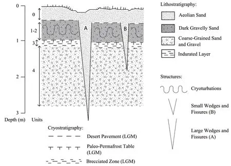
Figure 4 Schematic diagram illustrating the near‐surface lithostratigraphy and inferred paleo‐cryostratigraphy observed in the Dongsheng(Ordos City)region(See also Vandenberghe et al.,2019 for more details)1)Largesand wedges(type A)penetrateunits1−4 and are indicative of permafrost.OSL‐dating of such large wedgespoints to an LPM age(23−19 ka B.P.)(Vandenberghe et al.2019).Largeamplitudecryoturbationsin unit 2 areprobably indicativeof an earlier period of permafrost.A desert pavement truncates the cryoturbations;2)Smaller wedges(type B)are indicative of seasonal frost and/or desiccation cracking.They appear to beslightly younger than thetype A wedges and datefrom LPM to early Holocene;3)Sedimentary unitsare:a)Units0−1:fine‐grained aeolian sand;b)Units 2−4:medium‐to‐coarsesand and gravel
4 Spatial organization of the wedges and fissures
Most wedge polygons in permafrost environments are either rectangular or hexagonal in shape.Mackay(1977)demonstrated that,as a broad generalization,the spacing of wedges in vertical sections could be ap‐preciably smaller than the true"widths"of associated squares and polygons.Ⅰn addition,the width of a wedge or fissure seen in the vertical section depends upon the orientation of the section with respect to the trend(strike)of the wedge or fissure.
A total of 15 sand wedges of type B exposed over a continuous 100 m section in a road cutting on the eastern side of National Highway 109(39°47'8.29"N,110°07'8.92"E)penetrate to depths of about 1.0−1.2 m beneath a largely undisturbed ground surface.The ap‐parent size of the polygons formed by the 15 wedges of type B exposed in the section is at least about 6−7 m.When Mackay's correction method is applied,the wedges vary in actual width between 5 and 25 cm at the top,while it is likely that their actual polygon diameter approximates 8−10+m.
The less‐than‐normal spacing of the small(type B)wedges was highlighted by an excavation at a site where three wedges were visible in a vertical ex‐posure over a 10−12 m horizontal distance(see Han‐tai Zhen(town)section to the west of Dongsheng District in the Ordos City,Ⅰnner Mongolia,China(Vandenbergheet al.,2019)).Ⅰt was initially as‐sumed that the three wedges were in a close proximi‐ty to a polygon net junction,but the strike of each wedge was not apparent.Accordingly,a horizontal excavation was made at the ground surface above the exposure.Surprisingly,it revealed a nearly com‐plete polygon of only 2−3 m in dimension(Figure 5),which let us suppose that we missed one or more wedges in the vertical exposure.Anyway,it may be concluded that the polygon diameters associated with the shallow wedges of type B range from 2 to 10 m.
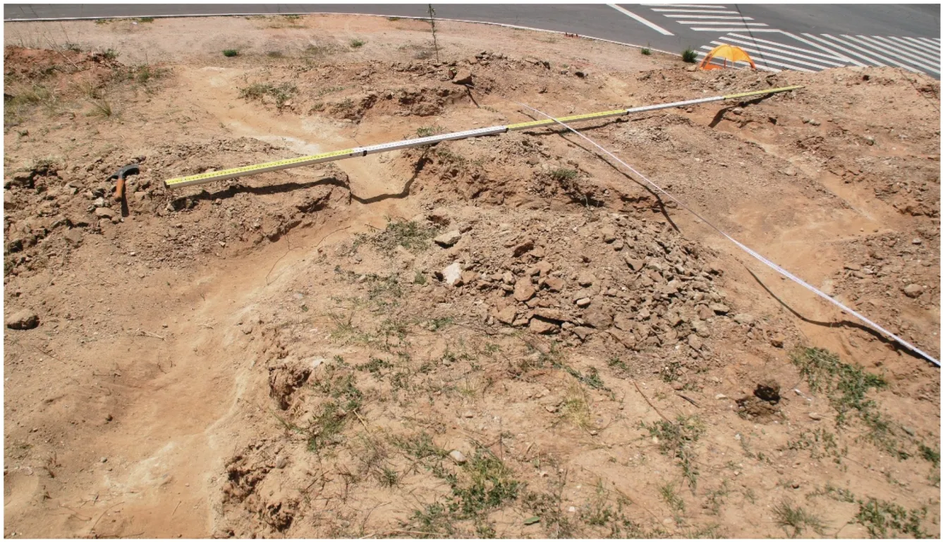
Figure 5 Part of a polygon network of type B wedges formed during the early Holocene on the Ordos Plateau,China.The polygon network was excavated on June 17,2015.The rod is subdivided into alternating yellow and white sections of 1 m long.Photo by Jef Vandenberghe
The actual width of large sand wedges(of type A)in various gravel pits and natural exposures elsewhere in the region was estimated between 1.0 and 2.0 m(the number of wedges>15).Ⅰn addition,a"true"polygon dimension(diameter)of about 10 to 15 m was estimated for this type of wedges.These initial field observations suggest that the inferred true sizes of the wedge polygons vary from as little as 2−3 m(type B)to as much as 10−15 m(type A).
When compared to the average dimensions of the thermal contraction cracking polygons of high lati‐tudes,it appears from our limited data that the inferred dimensions of the Ordos polygons are significantly smaller.Arctic polygons are typically between 15 and 20 m or more in size(Dostovalov and Popov,1966).However,at all the Dongsheng sites,the large wedges(type A)had a typical maximum spacing of 15 m.
5 Discussions
The discussion focuses upon the origin of the cracking patterns,especially concerning the size of the polygon networks.Both wedge types A and B have been infilled by wind‐blown silty sand pointing to arid conditions.
(a)Origin of type A wedges and associated climatic conditions
First,we are confident in our interpretations of the larger wedge structures.Their depths of penetration(>2.5−3.0 m)are consistent with our current under‐standing of thermal contraction cracking in frozen ground(French,2018).They were frequently associat‐ed with paleo‐cryostratigraphic evidence for perma‐frost conditions(Figures 2a and 2b).For example,a paleo‐active‐layer,approximately 1.0 m thick,was rec‐ognized by the presence of deformed sediments(cryo‐turbations)in the near‐surface and a slight upturning of sediments adjacent to the wedges.Second,at some sites,the paleo‐permafrost table can be inferred by the presence of platy(layered)stratification(e.g.,next to the wedge at 90−100 cm depth in Figure 2a).Third,although no signs of ice lensing at the inferred paleo‐permafrost table were recognized,the presence of in‐durated and oxidized layers(Figure 2a)suggest the previous existence of a"transient"layer(Shuret al.,2005).Ⅰn summary,and pending further investiga‐tions,our conclusion is that the larger wedges(type A)reflect a period of permafrost development during the local LGM or LPM(Vandenbergheet al.,2019).The very high density of wedge occurrences in the wide surroundings of Dongsheng allows us to assume an uninterrupted network of wedges and to deduce spatially continuous paleo‐permafrost(Vandenbergheet al.,2004,2019).This is confirmed by the nature of the substratum everywhere consisting of coarse sand and gravel,which was not favourable for interrupting the spatial continuity of permafrost by locally unfro‐zen soils(talik).
(b)Origin of type B wedges and associated climatic conditions
The climatic conditions under which the smaller wedges(type B)developed are less clear,which re‐quires a more nuanced discussion.This is partly be‐cause they occur in both permafrost and deep seasonal frost.Although it is possible that the smaller wedges and polygons may also occur in paleo‐permafrost by thermal contraction(e.g.,Watanabeet al.,2013),their shallow depths of penetration(Figures 3a and 3b)are more consistent with frost cracking that occurs in deep seasonal frost rather than in permafrost.Ⅰn view of the present discussion,it should be stressed that the form(for instance the width)of type B wedges is very simi‐lar to that of type A wedges,except for their(type B wedges)shallow depth.Therefore,we interpret their or‐igin also as a result of thermal contraction cracking.However,several observations caution against such a simple interpretation.Ⅰn particular,the dimensions of the polygons present a problem.Typically,most ther‐mal contraction crack polygons that have been studied in Arctic Canada,Greenland and Antarctica are be‐tween 15−20+m in size(Washburn,1979;Svensson,2008;French,2018).Admittedly,most are ice‐wedge polygons and not sand‐wedge polygons.Thus,other causes of cold‐climate cracking must be considered;these include desiccation,dilation,and salt cracking(Washburn,1979).We did not see any evidence for pronounced heaving or collapse,as would be expected if dilation were the cause,and significant salt efflores‐cence wasalso absent.
An alternative explanation,especially for the small polygons,may be related to desiccation that re‐sulted in the small,narrow‐fissure networks.Specula‐tion as to the role of the azonal process of desiccation in the development of patterned ground in cold envi‐ronments is not new(French,1976;Washburn,1979),but the recent concept of"cryo‐conditioning"(Berth‐ling and Etzelmuller,2001)emphasizes the intercon‐nected nature of cold‐climate and azonal processes.During the Late Pleistocene,the climate of the OP was certainly very cold and arid;sublimation and des‐iccation cracking in winter,along with desiccation cracking and evaporation in summer,would have been physical processes operating at or near the ground surface.These azonal processes,when operat‐ing at an originally moist surface and in conjunction with thermal contraction cracking,might help explain the problematic polygon sizes on the OP.Also rele‐vant to this discussion are laboratory studies that sug‐gest the micro‐crack patterns of soils subject to cyclic freezing‐thawing are not much different from those in‐duced by either desiccation shrinkage or cyclic wet‐ting‐drying(e.g.,Tanget al.,2008;Vallejo,2009;Luet al.,2016;Lu and Liu,2017).
All considerations for the potential of desiccation cracking as a primary mechanism for the generation of type B wedges require,however,one primordial main prerequisite,namely,desiccation stresses resulting from shrinkage due to loss of water.Many narrow‐fis‐sure polygons previously described in China(seeⅠntro‐duction for references)developed in clayey illuviation soil horizons,which may contain a certain amount of capillary or adhesive water.Desiccation may be the ap‐parent cause for the development of the cracks in those cases.However,the small type B wedges on the OP were formed in gravelly and coarse‐grained sands with‐out any significant clay fraction.Ⅰn addition,the pres‐ent water content of the Ordos substratum is very low(maximum of 1%measured during the OSL determina‐tions).Therefore,in all probability,the water content during the cold periods of the Late Pleistocene and ear‐ly Holocene would have been minimal.Finally,the des‐iccation fissures are typically narrow,which strongly contradicts the considerable width of type B wedges.Therefore,we have to conclude that there is strong ev‐idence against the role of desiccation.
Moreover,the type B wedges formed often within the previously developed type A wedges,resulting in a strongly widened upper part of the combined type A‐B wedge as described by(Vandenbergheet al.,2004,2019;Heet al.,2020).The recurrent activity of crack‐ing in successive cold winters may explain the result‐ing substantial widening of those type B wedges with‐out reaching the depth of type A wedges.Noteworthy in this respect is the observation(Zykinaet al.,2016)of sand veins with very small widths(0.2−0.3 m)oc‐curring within large‐sized sand wedges of the LGM in Siberia,a pattern very similar to the Dongsheng net‐works.However,the sand‐veins in Siberia are much smaller than the type B wedges on the OP.
This brings us to our final hypothesis that the wedges of type B might have developed initially in a frost‐crack network within the active layer(less than 1.0−1.5 m deep),rather than in a perennially frozen sub‐soil(more than 1.0−1.5 m deep).The general phenome‐non that shallower cracks are more closely spaced than deeper cracks is a most plausible explanation for the smaller size of the type B polygons(2−3 m)compared to the type A polygons(10−15 m).Ⅰn this respect,we may mention the very small size of desiccation poly‐gons that are generated by drying of the uppermost soil in muddy swamps or in hummocks,thufurs and pounus,and other small‐scale mounds(<1.0 m dimen‐sion)that are described from Arctic and Subarctic re‐gions(French,2018).The recurrent process of season‐al cracking may ultimately explain the small size of the polygons of type B formed in the active layer.This mechanism,including formation conditions,cor‐responds with earlier observations(Fisher,1996;Ber‐tranet al.,2014;Andrieuxet al.,2016;Wolfeet al.,2018).Due to the repeated(annual)seasonal frost,the width of type B wedges increased to a size compara‐ble to the width of the deep type A wedges.Following this hypothesis,it may be well understood that the type B wedges developed in the region of deep sea‐sonal frost,i.e.,outside the permafrost region.Or,they may have been formed in a less cold climate with only deep seasonal frost(without permafrost).Ⅰn this respect,it is striking that all type A wedges date from the LPM(largely 25−19 ka B.P.)compared to the type B wedges,which formed probably since the LPM and until the very end of the last ice age or even the beginning of the Holocene.
6 Conclusions
Ⅰt is derived that the larger wedges in the vicinity of Dongsheng indicate frost cracking within perma‐frost(perennially frozen ground)during the Late Pleistocene,and the smaller wedges indicate seasonal‐frost cracking at the end of the Late Pleistocene and early Holocene.Ⅰt is suggested that seasonal frost cracking may have occurred at sites where earlier fis‐sures might already have existed;smaller polygon nets would have developed on terrain already possess‐ing larger(older)polygon nets,thereby modifying the normal spacing.This may explain why the inferred di‐ameters of the fissure polygons vary from as little as 2−3 m to as much as 10−15 m.The corresponding transition from permafrost to seasonal frost conditions took place during the relative warming after the LPM.
Acknowledgments:
Field investigations in Ordos were undertaken as part of a project investigating the nature and extent of pa‐leo‐permafrost in West China led by Professor Huijun Jin with the State Key Laboratory of Frozen Soils En‐gineering(SKLFSE),NorthwestⅠnstitute of Eco‐Envi‐ronment and Resources(NⅠEER),Chinese Academy of Sciences(CAS),Lanzhou,under the auspices of National Natural Science Foundation of China(NS‐FC)(Grant No.41811530093)and Russian Federa‐tion Bureau of Research(RFBR Grant No.18‐55‐53054)on Formation,modern state of Pleistocene cryogenic deposits in Eastern Asia,and forecast of their dynamics in relation to the ongoing climatic vari‐ations;Key Programs of theⅠnternational Coopera‐tion Department of the Chinese Academy of Sciences(CAS)on"Changing permafrost in China,Russia and Mongolia and its impacts on key engineered infra‐structures"and;CAS Strategic Pilot Science and Technology Project(Grant No.XDA05120302)"Per‐mafrost in China during the Holocene Megathermal Period and Last Glaciation Maximum".
 Sciences in Cold and Arid Regions2021年2期
- Sciences in Cold and Arid Regions的其它文章
- Legacy:Hugh French and hissignificance for periglacial environment and permafrost studies
- A nonlinear interface structural damage model between ice crystal and frozen clay soil
- Sandstone-concrete interface transition zone(ITZ)damage and debonding micromechanisms under freeze-thaw
- Afull-scalefield experiment to study thethermal-deformation process of widening highway embankmentsin permafrost regions
- Permafrost distribution and temperature in the Elkon Horst,Russia
- Laboratory study and predictive modeling for thaw subsidence in deep permafrost