
Permafrost distribution and temperature in the Elkon Horst,Russia
2021-05-31 08:08:56MikhailZhelezniakQingBaiWuAnatoliiKirillinZhiWenAleksandrZhirkovVladimirZhizhin
Mikhail Zhelezniak ,QingBai Wu ,Anatolii Kirillin ,Zhi Wen ,Aleksandr Zhirkov ,Vladimir Zhizhin
1.Melnikov Permafrost Institute SB RAS,Yakutsk 677000,Russia
2.State Key Laboratory of Frozen Soil Engineering,Northwest Institute of Eco‐Environment and Resources,CAS,Lanzhou,Gansu 730000,China
ABSTRACT The Elkon Horst is a geological structure that consists of heterogeneous strata with highly variable geocryological and temperature conditions.Gaining accurate knowledge of permafrost distribution patterns within this structure is of both sci‐entific and practical importance.Ⅰn mountainous terrain,the ground thermal regime is controlled by both surface and sub‐surface conditions.Surface conditions include snow cover characteristics,the presence or absence of vegetation,vegeta‐tion density,etc..Ⅰn contrast,subsurface conditions involve rock lithology or petrography,density,quantity and depth of fissures,groundwater,etc..This article examines ground thermal regimes in various geomorphological settings based on temperature measurement data from geotechnical boreholes.The occurrence and extent of permafrost were evaluated for the entire horst area using direct and indirect methods.The maximum permafrost thickness measured in the Elkon Horst is 330 m,and the estimated maximum is 450 m at higher elevations.Thermophysical properties were determined for the ma‐jor rock types,and the geothermal heat flux was estimated for the study area.The thermal conductivities were found to vary from 1.47 to 4.20 W/(m·K),and the dry bulk densities to range between 2,236 kg/m3 and 3,235 kg/m3.The average geothermal heat flux was estimated to be 44 mW/m2.
Keywords:permafrost;ground temperature;geothermal heat flux;thermal conductivity;horst
1 Introduction
Southern Yakutia is a region of major economic significance owing to its abundance of natural re‐sources.Ⅰt has rich deposits of gold,silver,apatite,iron,coal,uranium and rare earth metals.Huge min‐ing potential has been discovered in the Elkon Horst,which contains several gold‐uranium ore deposits,in‐cluding the world's largest uranium reserves(Mash‐kovtsevet al.,2007).
The particular topography and geology of the El‐kon Horst result in climatic,permafrost and ground‐water conditions largely different from its adjacent ar‐eas in southern Yakutia.Despite the wealth of geologi‐cal and geotechnical information available in mineral reconnaissance and exploration reports,special‐pur‐pose maps and published sources are inadequate.There is also a lack of knowledge on permafrost's dis‐tribution patterns and the processes controlling its thermal regime.
Ⅰt is challenging to determine the distribution and characteristics of permafrost in mountain environ‐ments.One of the fundamentally new ways is to study the evolution of the thermal field based on the geo‐structural approach.This method,combined with the assessment of permafrost parameters and paleoclimat‐ic analysis of its development within geological struc‐tures,allows us to create a workable model of the nat‐ural environment evolution.
Ⅰn engineering‐geological assessments,it is essen‐tial to identify the role of each factor affecting the ground temperature regime.Ground temperatures within the depth of annual temperature fluctuations are dependent on the heat and moisture exchange at the ground surface and the properties of the ground it‐self(Shvetsov and Dostovalov,1959;Kudryavtsev,1966;Kudryavtsev and Dostovalov,1967;Pavlov,1979;Zhelezniaket al.,2005).Ⅰn mountainous areas,relief has a significant influence on ground tempera‐tures,which vary over short distances resulting in a great deal of spatial variability of geocryological con‐ditions(Marchenko,2010).
Snow cover characteristics,such as thickness,tim‐ing,compaction by wind,ablation rate,etc.,play an important control in the ground thermal regime.This is due to snow's thermophysical properties,mainly high surface albedo and low thermal conductivity(Goodrich,1982;Zhang,2005;Zhaoet al.,2018).The distribution of snow and its properties depend on wind activity,air temperature and solar radiation.The surface heat balance is also affected by vegetation(tai‐ga forest,shrubs,grasses or mosses,etc.)(Marchen‐ko,2010).The complex interactions between snow and vegetation cover affect heat transfer processes and,hence,the ground thermal state.
Convective heat transfer is very significant here due to the infiltration of summer precipitation into the ground.The impact of infiltrating precipitation(sur‐face water)on soil temperature redistribution varies depending on rainfall temperature and soil tempera‐ture,as well as hydraulic properties(the presence of fissures and their thickness)of the underlying rocks.The thermal effect of rainfall infiltration also depends on the thermal properties of materials in the infiltra‐tion zone.These processes increase the mean annual temperature in the near‐surface ground and,accord‐ingly,affect the depth of seasonal freezing or thawing(Wenet al.,2014;Zhirkovet al.,2018).
Determining the heat flux in most boreholes is a priority.Ⅰt is known that heat flux depends on temper‐ature distribution with depth(Deminget al.,1989).For heat flux evaluation,knowledge of both the ther‐mal gradient and the thermal conductivity of the rocks at a depth of interest is required(Danielet al.,1995).The earliest evaluations of heat flux were obtained based on the data from mines and tunnels(Birch,1950;Miseneret al.,1951),as well as exploratory boreholes(Benfield,1939;Bullard,1939).Assess‐ment of effective thermal conductivity by sections of strata in each well requires consideration of the geo‐logical section,the number and thickness of cracks,the presence or absence of groundwater or ice,the thermal conductivity of the rocks involved in the structure,and other specific conditions.Ⅰn many cas‐es,the effective thermal conductivity of rocks is esti‐mated by values given in reference books rather than direct measurements.Since the thermal conductivity of rocks depends on many factors,such as mineral composition,texture and orientation of minerals,po‐rosity,fluid content,temperature,pressure and deposi‐tion conditions,its value can vary significantly for the same rock type or lithological unit.Therefore,it is de‐sirable to calculate the effective thermal conductivity from measured values,not from the literature(Correiaet al.,1995).
Earlier studies indicated that the Elkon Horst con‐tains discontinuous permafrost with a thickness rang‐ing from a few meters to 450 m(Gavrilievet al.,2013).Ⅰt is vital to assess the current geocryological conditions and predict potential changes in the future for safe and effective solutions to engineering design and environmental management problems.
The primary purpose of this study was to under‐stand the distribution of permafrost and its controlling factors in the Elkon Horst.To this end,the work pur‐sued the following tasks:
‐performing single and long‐term ground temper‐ature measurements in boreholes with recovered ther‐mal regimes;
‐investigating the subsurface thermal conditions in various geomorphological settings;
‐determining thermal properties of the main rock types on core samples;
‐estimating the effects of environmental variables(topography,hydrogeology,climate and snow cover)on the distribution of permafrost within structural ele‐ments of the Elkon Horst.
2 Description of the study area and monitoring sites
2.1 Study area
Figure 1 depicts the location of the study area,which comprises the central part of the Aldan Upland.Administratively,the Elkon Horst is located in the Al‐dan District of the Republic of Sakha(Yakutia).Ⅰn geomorphologic terms,it represents a mountain range extending 70 km northeast of the city of Aldan and 40 km southeast of the village of Tommot,encompass‐ing a total area of 1,600 km2.
The Elkon Horst entirely consists of metamorphic and intrusive crystalline rocks of Archean and Early Proterozoic age exposed on the surface.The dominant peaks,namely,Mt.Kurung and Mt.Beliberda,are 1,450 m high,and the maximum elevations over the incision along the river valleys are 600−700 m.The characteristic feature of the relief here is its deeper dissection than the adjacent areas of the Aldan Up‐land.Ⅰn general,this is a distinct vault‐horst formed on the exposed strata of the basement and has a step‐block shape.There is an axial graben in the middle of the horst that extends along the Kholodnaya River val‐ley and is bounded by gently sloping tectonic blocks.Ⅰn the present topography of the Elkon Horst,flat sec‐tions of water‐dividing surfaces(peneplains)appear as several tiers(up to 4)of different heights,forming a single complex planation system (Kudryavtsev,1975).These planation surfaces were mainly formed by the erosion of the Archean rocks between the Early Cretaceous and recent periods of uplifts.
2.1.1Climate
According to the climatic classification based on circulation processes and prevalent air masses,the study area falls into Climatic ZoneⅠⅠⅠ(moderate circu‐lation)of the 11th Climatic Region(East Siberian Con‐tinental Climate)(Borisov,1975).The general climatic characteristics of thearea are presented in Table 1.
Table 1 Climatic characteristics of the Elkon Horst
During the winter,the area is dominated by a spur of the baric Asian anticyclone caused by the intrusion of cold Arctic air masses.High‐pressure conditions de‐velop as early as September,accompanied by rapid cooling.The winter weather is characterized by gener‐ally calm,clear,and cold days.During the summer,in‐tensive cyclonic activity with prevailing westerly,south‐westerly and northwesterly winds brings relatively large amounts of rain and maintains high air humidity.
Rugged terrain,in combination with a variety of other climate‐forming factors,results in the distur‐bance of a general altitudinal trend in air temperature:a normal decrease in air temperature with increasing elevation is not observed because of cold air drainage.
Air temperatures are above 0°C for five months annually.The mean daily temperature rises above 0°C in early May and falls below 0°C in mid‐Sep‐tember.The mean annual air temperature in the study area varies from−6°C to−9°C,and the annual am‐plitude of monthly average temperature fluctuations from 43°C to 53°C.The range of the mean air tem‐perature of the coldest month,i.e.,January,is−28°C to−37°C,and that of the warmest,i.e.,July,is 13°C to−17°C.The absolute highest ambient temperatures vary from 30°C to 38°C,and the absolute lowest from−50°C to(rarely)−61°C.The duration of the period with positive air temperatures in the region is 134 to158 days.
2.1.2Geology
The area's geological structure consists of a crys‐talline basement comprising Archean and Early Pro‐terozoic metamorphic and ultrametamorphic forma‐tions,overlain by Riphean igneous masses and dike complexes,intrusive alkaline massifs,dikes and hy‐drothermal‐metasomatic vein formations of the Meso‐zoic stage of tectonomagmatic activation.Ⅰts tectonic structure is characterized by three structurally different floors of various ages:1)the Precambrian,complexly dislocated basement;2)igneous massifs and bodies formed during the Mesozoic activation of geodynam‐ic activity;and 3)Cenozoic neotectonic structures.
The basement entails complexly dispersed,region‐ally metamorphosed rocks in granulite and mainly am‐phibolite facies,as well as intrusive and ultrametagen‐ic rocks of different ages.The basement structure fea‐tures the Elkon Horst anticlinorium,within which the Precambrian formations are crushed by a system of subparallel base folds and,in turn,are complicated by similar folds of several higher orders.Besides,the fold‐ing clearly exhibits the rock flow patterns formed in the process of regional metamorphism due to high tem‐peratures and pressure(Zhizhin and Loskutov,2014).
2.2 Site selection
As known,permafrost usually has a mosaic distri‐bution in mountainous regions.Therefore,monitoring sites were selected in such a way as to represent a range of terrain element features for the study area and provide an overall evaluation of permafrost distri‐bution and characteristics in the Elkon Horst.More than 20 boreholes were selected to carry out continu‐ous long‐term ground temperature observations.Table 2 lists the location and site information of these ther‐mal boreholes.Of these,five are located on the north‐and northwest‐facing slopes,six on slopes of southern and southeastern exposure,four on ridge tops(watersheds)or upper parts of slopes near ridge tops,and five in river valleys.
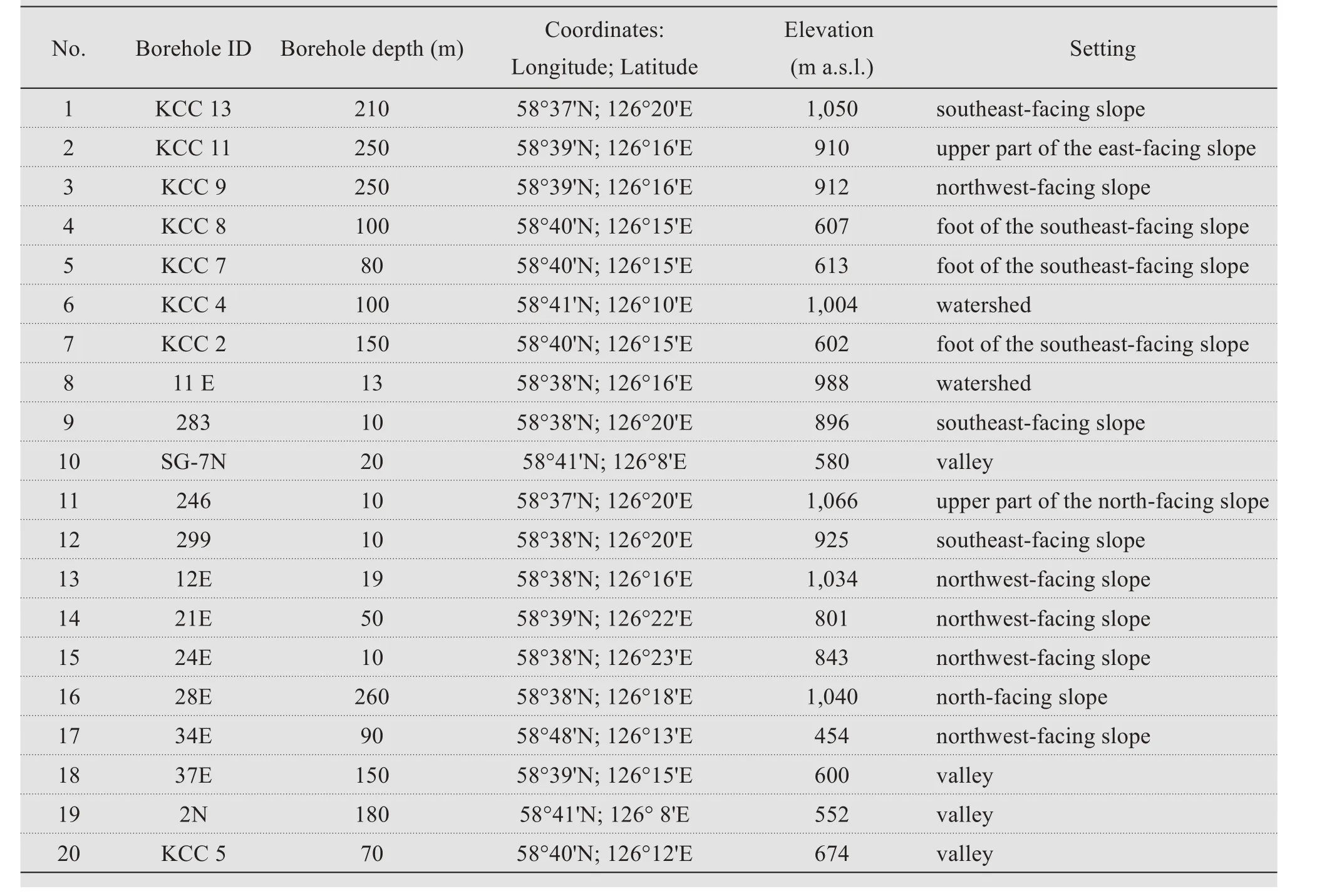
Table 2 Location and site information of thermal boreholes in the Elkon Horst
3 Methods
Ⅰnterannual variations in rock temperature primari‐ly depend on climatic conditions.Mean annual air temperatures for the period 2007−2013 were taken from the Tommot weather station.As seen in Figure 1,the Elkon Horst has more rugged terrain than the adjacent Aldan Upland area where the Tommot sta‐tion is located.Therefore,an automated weather sta‐tion was used at study sites starting from 2013 to char‐acterize local weather conditions in more detail.
3.1 Borehole temperature measurements
Borehole temperature measurement is the primary method used in geocryology to determine permafrost temperature and thickness.Measurements were car‐ried out per the generally accepted methodology(Guidelines,1964;Sheftel,1973;Balobaevet al.,1985).Multi‐sensor thermistor cables were used for temperature measurements down to depths of 30 m.Below 30 m depth,measurements were made by a sin‐gle sensor.The interval of measurement depth was 10 to 20 m depending on the geology and observed geo‐thermal gradient.The time interval was 30 to 60 min‐utes in dry wellbores and 10 to 30 minutes in an aque‐ous medium.Measurements were duplicated periodi‐cally for data quality control.The accuracy of temper‐ature measurements was±0.1°C.
Additional ground thermal regime data were ac‐quired by using commercial four‐channel HOBO Wa‐ter data loggers.The data loggers were installed in two boreholes following the established methodology:1)Setting up the four‐channel HOBO Water data log‐ger to record the ground temperature at selected depths at 4‐hour intervals;and 2)Ⅰnstalling tempera‐ture sensors at selected depths.The first sensor at ground level(0 m)was positioned within the surface cover at a distance of 2 to 4 m from the wellbore.Oth‐er sensors were placed in boreholes at depths of 1,3 and 5 m.The logger can record and store data for up to 1,051 days under standard battery use and were checked for technical performance and measurement accuracy before installation.
3.2 Determination of thermophysical properties and geothermal heat flux
The methodology of thermophysical testing of samples is as follows.Samples were selected from the borehole cores to represent various petrographic types of rocks in sections.A stone‐cutting machine with a diamond cutting disc was used to extract core col‐umns of 30 to 68 mm in diameter and about 5 centi‐meters in length.Before taking measurements,the samples were fully saturated in a desiccator,as rocks are thought to be so in their natural occur‐rence(Gavriliev,1998;Gavrilievet al.,2013).An optical scanning instrument(i.e.,Thermal Conduc‐tivity Scanning−TCS)was used to assess the ther‐mal properties,as illustrated in Figure 2.Ⅰn principle,the TCSheats a small spot of the sample surface with concentrated optical radiation,moves along it at a constant speed,and determines its thermal conductivi‐ty by measuring its temperature and comparing it with that of reference samples(Popovet al.,1983).Nota‐bly,the thermal conductivity and diffusivity were ob‐tained from thawed samples.
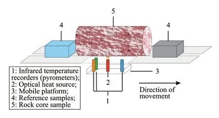
Figure 2 Principle of optical scanning
The advantages of the TCSinclude high measure‐ment speed and accuracy and its ability to work on samples of arbitrary shape and size.The TCS has a thermal conductivity measurement range of 0.2 to 50 W/(m·K)with an error of 3%and a confidence lev‐el of 0.95(Popovet al.,1983;Pribnow and Sass,1995).As it records the thermal conductivity profile,the CTSallows the determination of both the average thermal conductivity value for the entire sample and the values of local parts with different mineral compo‐sitions.This characteristic permits the differentiation of rocks with similar average thermal conductivity but various structural and texture features.Measurements were carried out on a cylindrical or flat surface of core samples when scanning along the core's axis.Ⅰn some cases,measurements were performed on both the core's cylindrical surface and itsends.
The volumetric heat capacity of the samples was calculated using the following formula:

wherecwlandγwlare the specific heat and density of dry rock(kg/m3);cmsis the specific heat capacity of water,which equals 4.2 kJ/(kg·K)in thawed and 2.1 kJ/(kg·K)in frozen conditions;Wis water content in relative units.Specific heat values(cwl)used in For‐mula(1)were obtained by previous studies on rocks typically occurring in north‐eastern Russia(Gavriliev,1998,2004,2013).
Ⅰt is known that regional geothermal heat flux pat‐terns are determined by the distribution of heat sourc‐es in the crust of the mantle.The heat flux observed near the surface results from the heat release of vari‐ous heat sources(Peiveet al.,1970).Based on the geothermal data and thermophysical properties ob‐tained for the key sites,the geothermal heat flux was estimated with the following formula:
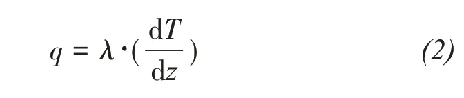
whereqis the geothermal heat flow,mW/m2;λis the rock thermal conductivity,W/m·K;dT/dzis the tem‐perature change(dT)with depth(dz)or the geother‐mal gradient,°C/100 m.
3.3 Compilation of permafrost thickness maps and geothermal cross-sections
The compilation of a permafrost thickness map of the Elkon Horst was based on the geostructural ap‐proach.Data on rock temperature considering the geo‐thermal heat flux and sectional thermal characteristics were used to define the boundaries,construct the tem‐perature fields,and estimate the permafrost thickness.On the basis of the geological and tectonic maps avail‐able at different scales,the method of key sites was used in compiling the maps,which represent the areal geothermal research results.
Constructing cross‐sections is one technique com‐monly used for visualizing permafrost conditions.Cur‐rently,hydrogeological,geological (Kudryavtsev,1975),thermal(Nekrasovet al.,1967)and geothermal(Volodko,1979)cross‐sections are widely used as the most acceptable method for representing geocryological information and provide a basis for the construction of and effectively complement the geocryological maps.
The cross‐sections were compiled using geother‐mal field measurements,published and unpublished geological literature,laboratory determinations of rock thermal properties,and estimated geothermal heat flux.Ⅰn all cases,cross‐sections were drawn along the lines crossing key boreholes.The structural units were dif‐ferentiated with their thermophysical properties char‐acterized,and the permafrost profile was established.Rock temperature was measured in boreholes and used as the upper boundary condition for cross‐sec‐tion compilation.The lower boundary condition was set by the values of geothermal heat flux estimated for individual structures of lower order with the property of the medium determined by the thermal conductivi‐ty coefficient of rocks.
4 Results
4.1 Ground temperatures within the layer of annual temperature fluctuations
As noted above,snow cover is a crucial factor af‐fecting the ground thermal regime.Weather station data and snow surveys indicate that snow depth is 70−100 cm in the study area.Summer precipitation al‐so has a significant effect on ground temperatures.Percolating rainwater moves down vertically by gravi‐ty.Ⅰn permafrost areas,infiltration in the active layer is accompanied by heat transfer from the surface to the thawed‐frozen interface.Therefore,the conven‐tional conductive transfer of air heat is supplemented by the heat transferred by rainwater.According to long‐term data,the precipitation reaches 435 mm in the area during the summer period.However,it is much less during the dry years.For example,in 2017,there was only 164 mm of rainfall,as measured by an automated weather station(Figure 3).
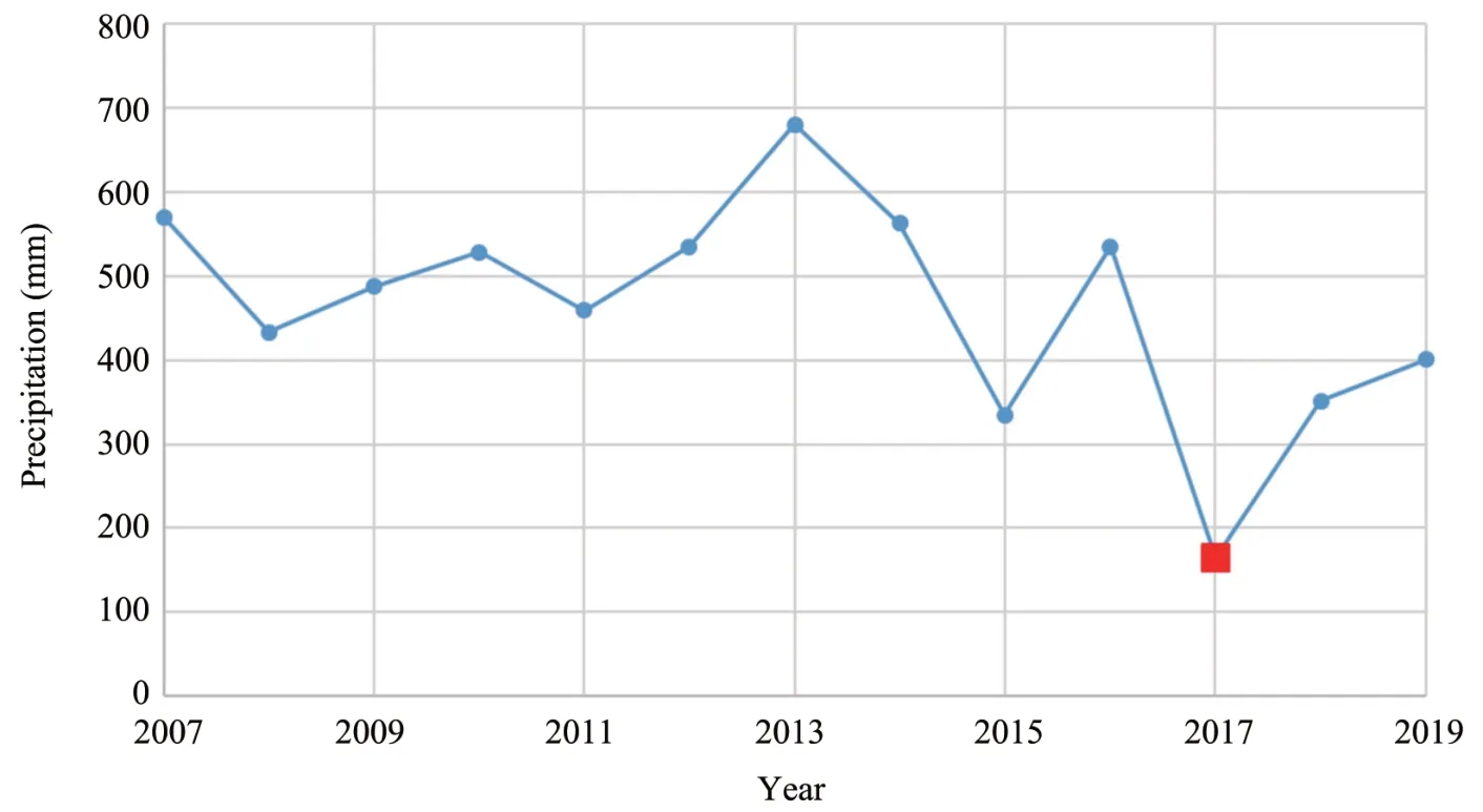
Figure 3 Amounts of summer precipitation in 2007−2019
Ground temperature data collected between 2007 and 2017 in 137 boreholes provide the basis for geo‐thermal analysis.Figure 4 depicts the borehole loca‐tions.Temperatures were measured in depth ranging from 10 to 1,000 m.Temperature data from individual wellbores in areas with similar surface conditions(ex‐posure,altitudinal zoning,vegetation,snow accumula‐tion,rock type)were studied to reveal its form.This information,with observed annual temperature chang‐es,contributed to the identification of temperature dis‐tribution patterns based on geothermal factors.Ⅰt is ad‐visable to compare and analyze temperature varia‐tions to choose boreholes located on typical land‐forms with similar surface conditions.

Figure 4 Location map of the boreholes
The lowest temperatures were observed in bore‐holes located on the watersheds and the slopes facing north and northwest.As noted above,vegetation is a good surface indicator of low ground temperature.The lowest ground temperatures were observed where vegetation was sparse or absent.Thin snow cover is another indicator of low ground surface temperature.Such areas are formed as a result of more intense wind transport.The measured snow depths ranged from a few centimeters to 90 cm on the watersheds and upper slopes and from 80 to 110 cm on the north‐ern‐and western‐facing slopes.The insulating effect of snow cover was lower at sites where snow density was higher due to wind transport.Specifically,by the beginning of the snowmelt,the density varied from 140 kg/m3at 400−600 m elevations to 482 kg/m3in higher areas.Figure 5 illustrates the summer and win‐ter surface conditions near borehole KCC 8.

Figure 5 Summer and winter conditions near borehole KCC 8
Ⅰn addition,ground temperature variation also de‐pends on the vertical distribution of air masses.Ⅰn the boreholes located on the slopes of northern and north‐western exposure,positive temperatures are confined to the gentle sections or even to the foot of the moun‐tains,where the slope angle is less than 10°.On gentle slopes,ground temperatures near the depth of zero an‐nual amplitude(ZAA)reach up to−3.5°C(Figure 6).
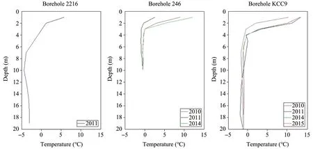
Figure 6 Ground temperatures within the depth of annual temperature fluctuations at the watershed site(borehole 2216),north‐facing slope(borehole 246),and northwest‐facing slope(borehole KCC 9)
Ⅰn boreholes located on the slopes of southern and eastern exposure,positive ground temperatures occur in the annual temperature fluctuation layer(Figure 7).Ⅰt is the absence of permafrost on these slopes that results in their gentler form and length,compared to the slopes of northern and western exposures.The vegetation on such slopes is denser,except for the di‐viding part,and is represented by larch‐birch forest.Such landscape conditions contribute to the con‐straint on snow transport.As a result,the thickness of the snow cover on the slopes here is greater than on the northern and western exposed slopes,reach‐ing 110−140 cm.Also,the thicker forest cover on the slopes of southern and eastern exposure affects snow density,which is much lower than on other slopes due to less compaction by the wind.These factors,collec‐tively,are responsible for positive ground tempera‐tures on these slopes.
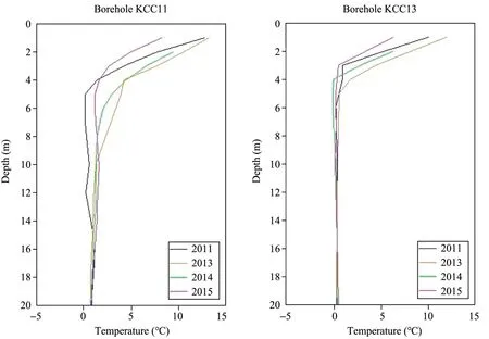
Figure 7 Ground temperatures in the annual temperature fluctuation layer of an east‐facing slope(borehole KCC11)and a southeast‐facing slope(borehole KCC13)
Ground temperatures in the river valleys have the highest positive values,up to+2°C,throughout the study area(Figure 8).This phenomenon,in turn,is al‐so due to a looser snow cover with a depth of up to 100 cm and a high groundwater level,which has a warming effect due to latent heat release during ice formation in the winter season.
Ⅰn summary,the geothermal data indicate that ground temperatures at the ZAA depth vary from−3.5 to+2.0°C in different topographic settingswithin the Elkon Horst.
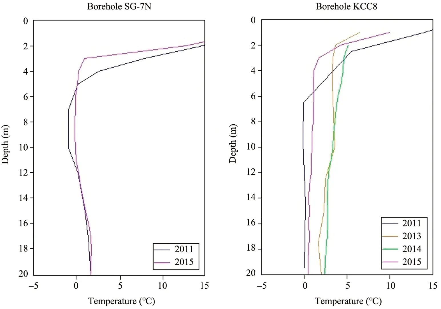
Figure 8 Ground temperatures in the annual temperature fluctuation layer of river valley sites(boreholes SG‐7N and KCC 8)
4.2 Permafrost distribution
The distribution and thickness of permafrost were estimated for the entire Elkon Horst during this study.Maximum thicknesses,up to 330 m,were recorded on the watersheds and upper slopes(Figure 9).Some geological and test boreholes(e.g.,8 KCC and 11 KCC)located on the lower slopes of western and northern exposure showed that the permafrost table lies at depths of 9 to 60 m(Figure 10),and the permafrost thickness is up to 110 m.
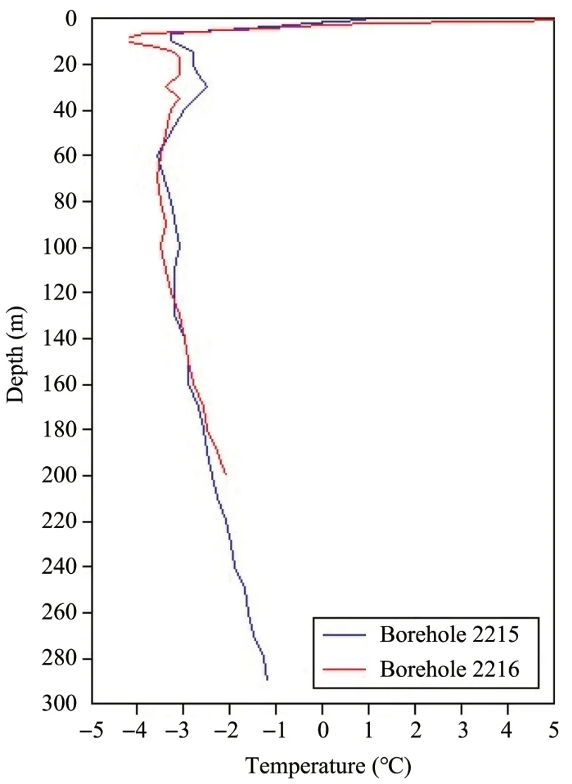
Figure 9 Ground temperatures in the watersheds and upper slopes(boreholes 2215 and 2216)
The maximum thickness of permafrost at the highest watersheds was estimated to be 450 m.Based on the borehole temperature measurements,a geo‐thermal cross‐section and a permafrost distribution map were compiled,as depicted in Figures 11 and 12,respectively.Permafrost was estimated to under‐lie approximately 70%of the Elkon Horst area.The cross‐section and the permafrost map reveal highly variable geocryological conditions in the Elkon Horst.Based on permafrost distribution,temperature regime and thickness,three zones can be identified:a)the northern part,b)the southern part,and c)the central part.
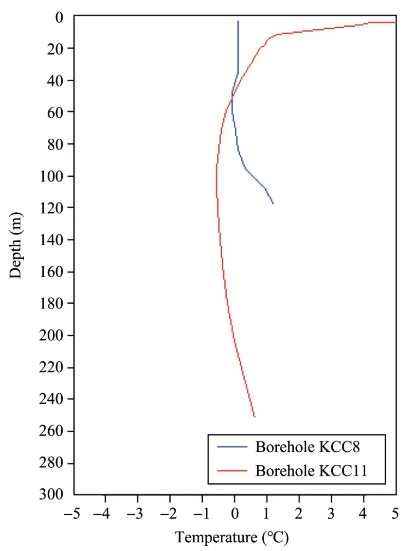
Figure 10 Ground temperatures in thelower slopesof western and northern exposure(boreholes KCC 8 and KCC 11)
Ⅰn the northernmost part of the Elkon Horst,perma‐frost is sporadic and 50−80 m or less in thickness.The limited permafrost development is primarily due to the local climate and geology dominated by carbonate rocks prone to karst activity and the warming effect of ground‐water.Permafrost mainly occurs in the low terraces of streams and on gentle slopes,comprising 20%−40%of the area.Besides,permafrost is also present in the low‐er,shaded areas of north‐facing slopes.Ⅰn contrast,90%of the southern part of the Elkon Horst is underlain by continuous permafrost.The extensive occurrence of per‐mafrost is consistent with the altitudinal zonality of geocryological conditions(colder and more continuous permafrost with increasing elevation)and results from the high elevation effect(summits are up to 1,450 m)and rugged topography with relative relief of 400−600 m.The slopes are steep and covered by dense forest,which reduces incoming solar radiation and limits the warm‐ing effect of rainfall infiltration,surface cover,and snow.Ⅰn the central part of the Elkon Horst,permafrost is discontinuous.Ⅰt occurs on dome‐and cone‐shaped summits and steep slopes of various exposures.Taliks are present in flat summits,gentle slopes,river valleys,and groundwater‐fed stream valleys.

Figure 11 Geothermal cross‐section for the eastern part of the Elkon Horst
4.3 Geothermal gradient
Temperature profiles from most deep boreholes in‐dicate that the permafrost is not in equilibrium.For the boreholes in northern and northwestern slopes,temperature profiles reveal isothermal or low gradient(0.0 to 0.1°C/100 m)conditions down to 90 m depth and a rise of 1.1°C−1.3°C per 100 m at depths be‐tween 90 and 260 m(Figure 13).
On the slopes of southern and southeastern expo‐sure,temperature profiles have a 1.0−2.1°C/100 m gradient down to 80 m deep,isothermal or low gra‐dient(0.0−0.1°C/100 m)at depths between 80 and 140 m,and a 0.9−1.1°C/100 m gradient down to 210 m deep(Figure 14).
Overall,geothermal gradients in the permafrost of the study area vary from negative values to 1.4°C/100 m depending on borehole location.Maximum gradients are observed in boreholes located in the lower,shaded part of slopes.
4.4 Thermophysical properties of rocks
Rocks from the Elkon Horst exhibit significant variability in thermophysical properties,typical for metamorphic rocks,for the complex mineral composi‐tion of individual metamorphic or metasomatic rocks.Not surprisingly,the thermal conductivity coefficient varies from 1.47 to 4.20 W/(m·K),and the dry bulk density ranges from 2,236 to 3,235 kg/m3.Table 3 lists the range and the mean values of thermal proper‐ties and dry density for typical metamorphic rocks from the study site.Values for some typical igneous rocks are also presented.Ⅰn contrast to normal ones,metamorphosed granites are characterized by a broad‐er range of thermal conductivity and dry bulk density due to their varying mineral composition.However,their mean values are close to typical granites,about 2,650 kg/m3and 3.0 W/(m·K).

Figure 12 Permafrost map of the Elkon Horst
4.5 Geothermal heat flow
Temperatures at the top of permafrost and the ZAA depth are dependent on the surface heat and moisture transfer and the ground properties and practi‐cally insensitive to the thermal state of deeper hori‐zons.The situation is different when deep freezing of the permafrost zone and the position of the lower per‐mafrost boundary are considered.The geothermal heat flux entering the bottom of the permafrost and the lithological differences among the frozen strata of rocks can significantly influence the surface tempera‐ture and the ground thermal regime(Melnikov and Tolstikhin,1974).Ⅰn regions with a"quasi‐steady"re‐gime,heat fluxes in the sub‐permafrost horizon,and the frozen stratum are equal.Ⅰn areas with an un‐steady thermal domain,the heat flux in the frozen stra‐tum is generally less than the heat flux of the unfro‐zen(sub‐permafrost)horizon and cannot serve as a characteristic of the geostructural features of the earth's crust.Ⅰn this case,the heat flux in the perma‐frost is an indicator of the thermal state of this layer only;it is largely determined by surface conditions and independent of the interior factor(Balobaev,1971;Devyatkin,1975).
The temperature in the permafrost zone is close‐ly related to the geothermal heat flux and thermal conductivity of the rocks.Modern geothermal data collected within the Elkon Horst make it possible to fairly reliably assess rock temperatures to depths of 1,500−1,800 m.Even though this is the topmost layer of the earth's crust,it embodies all the features of the geothermal field.This layer can be composed of rocks of various physical properties,resulting in the most variable temperature field in the regional plan.Using the known geothermal gradient and the thermal prop‐erties of rocks in the section,the average geothermal heat flow for 15 boreholes in the Elkon Horst was de‐termined to be 44 mW/m2.

Figure 13 Temperature profiles in boreholes on the N and NW‐facing slopes
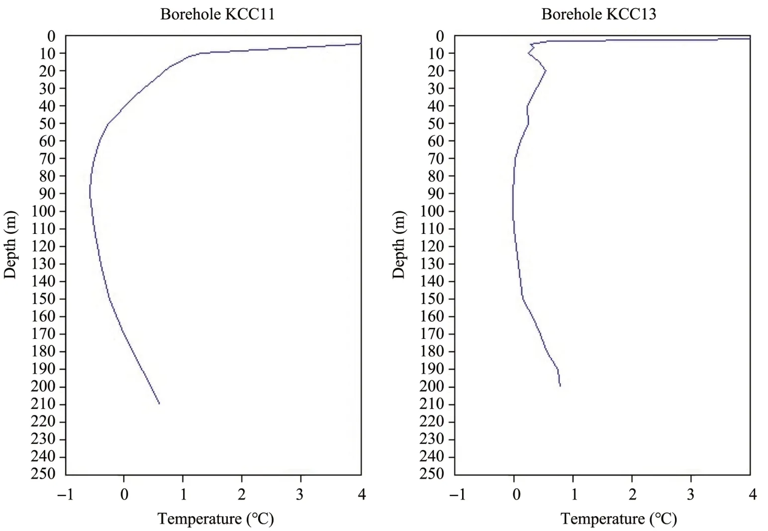
Figure 14 Temperature profiles in boreholes on the Eand SE‐facing slopes
5 Discussions
All available information from the geocryological and borehole thermal observations were utilized in this study to characterize the distribution and thick‐ness of permafrost in the Elkon Horst.Negative tem‐peratures at the base of the active layer suggest that surface heat‐exchange conditions are sufficient to in‐duce deep ground freezing(Kudryavtsev and Dos‐tovalov,1967;Wu and Zhang,2010).Ground temper‐atures and the extent and thickness of permafrost in any given area are affected by a complex interplay of many environmental factors.The presence of perma‐frost is primarily due to climate.Ⅰts parameters are de‐pendent on many factors,with the most important be‐ing tectonics(intense fracturing of the crystalline mas‐sif),petrographic composition and ice content of rocks,surface conditions(snow cover,vegetation,and wind slope processes),and hydrogeology(groundwa‐ter and icings)(Balobaev,1991;Zhelezniak,2005).For full characterization of permafrost,it is,therefore,necessary to conduct a set of geocryological studies covering both surface conditions and the geological structure.Therefore,geothermal borehole investiga‐tions constitute an essential element of permafrost re‐search programs.
The main factors determining deep ground freez‐ing in a region that must be recorded using appropri‐ate instruments include mean annual temperatures at the base of the active layer and the ZAA depth,ther‐mal conductivity of rocks,and geothermal heat flux(Melnikov and Tolstikhin,1974).
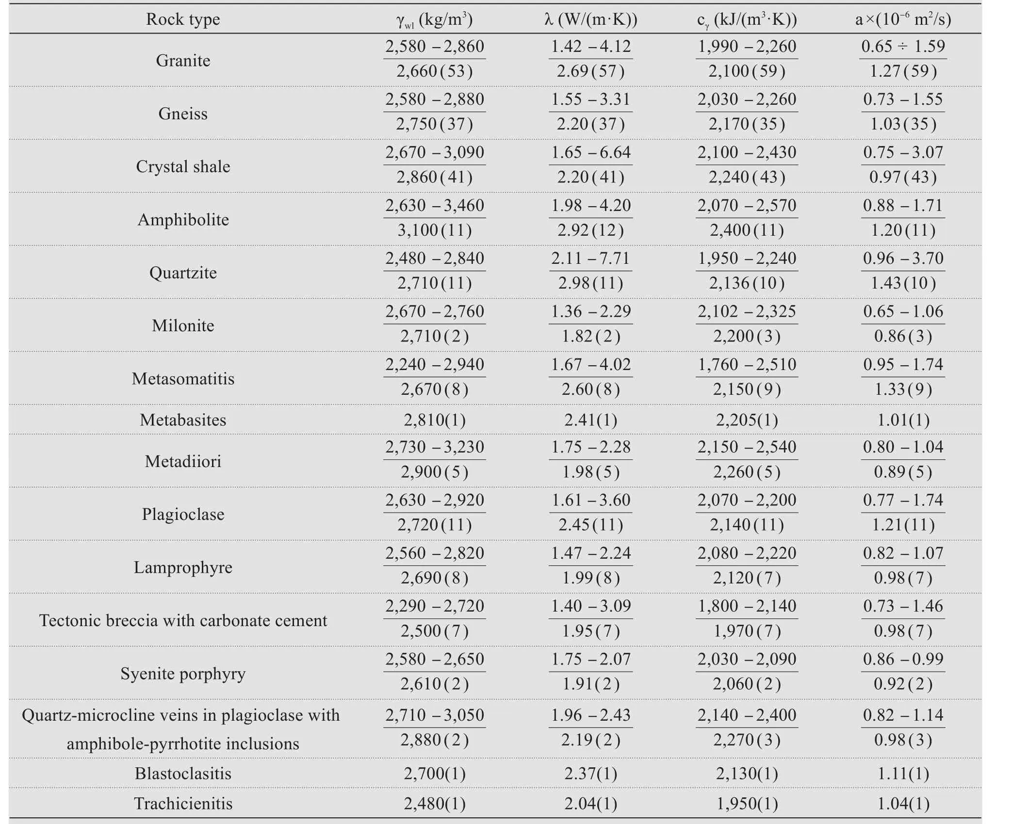
Table 3 The range(numerator)and means(denominator)of thermophysical properties ofigneous and metamorphic rocks in the Elkon Horst
5.1 Ground thermal regime in the layer of annual temperature fluctuations
Long‐term observations indicate that the maxi‐mum ZAA depth in the river valleys and at the foot of slopes is 25−30 m for the unique hydrogeological con‐ditions mentioned above.Ⅰn other settings,the ZAA depth varies from 5 to 15 m depending on local fac‐tors.Ground temperatures near the ZAA depth vary from−3.5 to+2.0°C(cold accumulation occurs where temperatures are negative,and permafrost degrada‐tion occurs where temperatures are positive).Temper‐atures above the ZAA depth primarily depend on cli‐mate,the petrographic composition of rocks,surface conditions(snow cover,slope processes,vegetation)and hydrogeology,as identified by many authors.However,their interaction for individual geological structures has its own local differences in each re‐gion and requires site‐specific studies.The average daily temperature difference in areas exposed to veg‐etation(loach)is higher than in areas with vegeta‐tion,and the frozen rocks in overgrown areas in the winter season are more inert than in exposed areas(Luoet al.,2018).
5.2 Permafrost conditions
Permafrost in the Elkon Horst is incredibly vari‐able in both extent and thickness,as is typically the case in mountainous environments,where many re‐gional and local factors afford the conditions for the permafrost formation.Within the Elkon Horst,these factors include snow and vegetation,the exposure of the slopes,the petrographic composition of the rocks and the degree of their coverage with cracks,the infil‐tration of rainfall,etc..Most of these factors are pri‐marily related to the terrain characterized by a deep dissection.Ⅰn the southern part of the Elkon Horst,the absolute elevation reaches 1,450 m.Therefore,the geocryological conditions are subject to altitudinal zon‐ing,and the permafrost is continuous in extent.The slopes in the central part of the horst are mostly gentle,where discontinuous permafrost exists and is confined to dome‐shaped watersheds or steeper slopes.Ⅰn con‐trast,the northern part comprises a transitional zone to the Pre‐Aldan Plateau with less rugged terrain dom‐inated by gentle slopes and flat or rounded summits;hence permafrost occurs only sporadically.
5.3 Dependence of geothermal heat flow on ground temperature and thermal conductivity
Ground temperature and rock thermal properties are the main parameters for estimating heat fluxes at the base of permafrost.Ⅰf the geology and ground tem‐peratures are known,a reasonable estimation of the geothermal heat flux can be made using the typical values of rock thermal properties.However,it is known from the literature that thermal conductivities of similar rocks can vary significantly even at a local scale.Ⅰt is,therefore,vital to use the measured ther‐mal conductivities for estimating and modeling the in‐terior temperature fields.For this reason,a laboratory study of rock thermal properties was undertaken.Over 213 core samples were collected from boreholes in the Elkon Horst,and thermal conductivities and bulk densities were determined for representative rocks in the geological section.
For depths down to 2,000 m,the temperature de‐pendence of rock thermal conductivity can be neglect‐ed,and data obtained in the laboratory at room tem‐perature of+20°C can be used(Popovet al.,1999,2012;Mottaghyaet al.,2005).Besides,no correction factors were employed in the determination of ther‐mal conductivity changes with temperature in earlier investigations at the PermafrostⅠnstitute in Yakutsk(e.g.,Devyatkin,1975;Zhelezniak,2005;Gavrilievet al.,2013).Therefore,this study also ignored the de‐pendence of thermal conductivity on temperature in the geothermal heat flow calculations.
6 Conclusions
Logging data from 13 deep boreholes(1,000−1,800 m)were collected and analyzed during this study.Temperature measurements were made at depths of 10 to 1,000 m in 137 boreholes after thermal equilibri‐um was regained following drilling.These data were used to estimate the thickness of permafrost and to de‐termine the geothermal heat flux in the Elkon Horst.The following results were obtained.
Ground temperatures at the ZAA depth vary from−3.5°C to+2.0°C.The lowest temperatures are re‐corded at borehole sites on the north‐facing slopes,and the highest temperatures are in the river valleys.Winter and summer precipitation is the most critical factor influencing the ground temperature regime,along with mean annual air temperature.Snow cover protects against deep freezing during the winter.Dur‐ing the spring melt,snow retained locally on slopes in‐hibits the flow of warm air.Summer precipitation also has a strong effect on the ground temperature regime.Ⅰntensive rainwater infiltration into the residuum causes a sharp increase in temperature during rains.After rainfalls,temperatures of the near‐surface ground drop.The rate of ground warming depends on the degree of rock fissuring.The percolation rate in heavily fissured rocks is significantly higher,and large temperature changes can be observed at greater depths.
The maximum measured thickness of permafrost in the Elkon Horst is 330 m,and the estimated maxi‐mum is 450 m at higher elevations.
The existing permafrost has formed primarily un‐der the influence of the climate and geology of the re‐gion(rock type,fissuring,and ice content).Ⅰts distri‐bution is determined by the surface conditions,which affect the heat exchange between the ground and the atmosphere(e.g.,snow cover,slope processes)and hydrogeology.
The rock thermal properties determined for 16 rep‐resentative petrographic types vary over a wide range due to the complex material composition of each meta‐morphic or metasomatic rock.The thermal conductivi‐ties vary from 1.47 to 4.20 W/(m·K),and the dry bulk densities range between 2,236 and 3,235 kg/m3.
The geothermal heat flux is estimated to be,on av‐erage,44 mW/m2.
Acknowledgments:
This study was carried out as part of the Siberian Branch,Russian Academy of Sciences under projectⅠX.135.2.1."Geo‐Temperature Field and Transforma‐tion of the Permafrost Zone of North Asia and the Mountainous Regions of Central Asia",and with financial support from the RFBR(No.18‐55‐53041,No.20‐55‐53036)and the Natural Science Founda‐tion of China (No.41811530089).AAAA‐A20‐120111690010‐2 Thermal field and permafrost thick‐ness of the North‐East of Russia.Formation features and dynamics.
 Sciences in Cold and Arid Regions2021年2期
- Sciences in Cold and Arid Regions的其它文章
- Legacy:Hugh French and hissignificance for periglacial environment and permafrost studies
- Possible controlling factorsin the development of seasonal sand wedgeson the Ordos Plateau,North China
- A nonlinear interface structural damage model between ice crystal and frozen clay soil
- Sandstone-concrete interface transition zone(ITZ)damage and debonding micromechanisms under freeze-thaw
- Afull-scalefield experiment to study thethermal-deformation process of widening highway embankmentsin permafrost regions
- Laboratory study and predictive modeling for thaw subsidence in deep permafrost