
Aeolian processes on sandy desertification of an alpine meadow:A wind tunnel experiment
2020-06-02 02:54ZhiShanAnKeCunZhangLiHaiTanBaiChengNiuYanPingYu
ZhiShan An ,KeCun Zhang ,LiHai Tan ,BaiCheng Niu ,YanPing Yu
1.Northwest Institute of Eco-Environment and Resources,Chinese Academy of Sciences,Lanzhou,Gansu 730000,China
2.Dunhuang Gobi and Desert Research Station,Northwest Institute of Eco-Environment and Resources,Chinese Academy of Sciences,Lanzhou,Gansu 730000,China
3.Key Laboratory of Desert and Desertification,Chinese Academy of Sciences,Lanzhou,Gansu 730000,China
4.University of Chinese Academy of Sciences,Beijing 100049,China
ABSTRACT In recent years,the desertification of alpine meadows has become a serious ecological problem and has gradually become a threat to regional economic activities in Maqu County.To reveal the mechanism for sandy desertification of alpine mead‐ows,we conducted wind tunnel experiments on aeolian processes over sandy alpine meadows.Results show that the sandflux profile of mix-sized sediment decays exponentially with increasing height.However,the profile pattern of a group of uniform-sized particles depends on the experimental wind speeds.The profile pattern of all the groups studied can be ex‐pressed by exponential decay functions when the wind speed is less than or equal to 16 m/s.while that for all the groups studied can be expressed by a Gaussian distribution function when the wind speed is above 16 m/s.The average saltation heights of mixed sands at wind speeds of 12 m/s,16 m/s,20 m/s,and 24 m/s were 2.74,4.19,5.28,and 6.12 cm,respec‐tively.The mean grain size basically first decreases and then increases with increasing height under different wind speeds.The sorting improves with increasing wind speed,while the kurtosis and skewness show relationships with only the char‐acteristics of the parent soil.
Keywords:alpine meadow;sandy desertification;aeolian erosion;aeolian transport
1 Introduction
Desertification is a process of deterioration in eco‐systems of arid and semiarid areas,resulting from in‐terplay between climatic variations and human activi‐ties(Dregne,1985;UNEP,1992).Desertification not only leads to a reduction of vegetative cover,regional biodiversity,and deterioration of the ecological envi‐ronment but also causes a variety of natural disasters,including sandstorms.In the process of soil desertifi‐cation,the original fine matter of the soil is blown away by wind or immersed in water, leaving the coarser sand;and a large amount of nutrients such as N,P,and K are lost(Boet al.,2013;Zhenget al.,2013).After that,the soil fertility is seriously re‐duced; and then soil productivity is also reduced.Thus,the natural environment of the region is natural‐ly restored very slowly,as compared with that of natu‐ral grassland(Dlamini,2014).
Grassland accounts for approximately one-quarter of the earth's land area.It is an indispensable part of the earth's ecosystem.Its stored carbon accounts for about 10%of global carbon sinks(Liet al.,2000),and it has a great impact on the regional atmospheric environment(Ojiamaet al.,1993).Besides,grassland can effectively prevent regional soil erosion by in‐creasing surface roughness,conserving water sources,and improving the physical and chemical properties of surface soil(Reeves,1997;Franzluebbers,2002).However,with the increase of global temperature and total population in recent years,the human demand for food,land,and meat has increased,leading to ex‐cessive reclamation or grazing of grasslands or forests and resulting in severe desertification of the grass‐land.The desertification of grassland and its impact on the ecological environment has always been a re‐search hotspot,drawing the interest of many scholars.The results of Manabe and Wetherald(1986)indicat‐ed that global warming will likely exacerbate the deg‐radation in arid and semiarid zones of northern China,as was true on a large scale in North America.In the process of grassland desertification, the dominant plant species in the grassland change.The high-quali‐ty pastures dominated by grasses are transformed into low-quality pastures dominated by poisonous weeds and weeds.At the same time,the number of vegeta‐tion types and the extent of surface vegetation in the pastures reduces.A series of environmental problems has been coming,such as the erosion of soil fines and the loss of nutrients(Manabe and Wetherald,1986;Chenet al.,1992;Linet al.,1993).In addition to the influence of natural factors on grassland desertifica‐tion,human activities are also important causes of de‐sertification.Excessive grazing and unreasonable land use are important causes of grassland desertification(Rusch and Oesterheld,1997;Sheng,2000).Longterm overgrazing leads to changes in plant communi‐ties on the pasture and loss of nutrients in the soil,re‐ducing forage yield and then creating a vicious circle.Unreasonable land-use methods include over grazing or cultivation.Because the land after tillage can grow crops only in summer,the cultivated land turf lacks the protection of vegetation in autumn and winter,both of which are windy seasons.The wind can direct‐ly act on the exposed surface,which provides conve‐nient conditions for the occurrence and development of desertification.
Most of the research areas mentioned above are concentrated in arid and semiarid regions (Wang,2004),in which the average annual precipitation is less than 400 mm(Ci and Wu,1997);but there is less research on grassland desertification in semi-humid or humid regions with an annual precipitation of more than 400 mm.The reason is that the precipitation in the semi-humid or humid area is great enough to meet the physiological needs for most vegetation.The selfrepairing ability of the ecosystem in the region is in‐comparable to that in semiarid and arid regional eco‐systems.The species,quantity,and coverage of the vegetation and the self-recovery ability of the ecosys‐tem can effectively prevent soil erosion and desertifi‐cation in the region.However,the results of the study indicate that the desertification of alpine meadows in humid areas has become a serious ecological problem in the region and has gradually threatened regional economic activities.Although there are research re‐sults on alpine meadow desertification—such as the desert-sand environment evolution;change of deserti‐fication area and reasons;plant species;community and soil microbial,physical,and chemical properties(Donget al.,2010)—few studies have focused on the process and desertification mechanism on the alpine meadow.The resolution of this problem is not only beneficial to understanding the desertification process in high-altitude and sub humid regions,but also to en‐vironmental scientists and land managers,who can take pertinent action to prevent the worsening deserti‐fication of alpine meadows.
2 Material and methods
2.1 Study area
Maqu County is located on the eastern edge of the Qinghai-Tibet Plateau at the junction of Gansu,Qing‐hai,and Sichuan provinces.It lies between the longi‐tudes of 100°45′45″E and 102°29′00″E and the lati‐tudes of 33°06′30″N and 34°30′15″N(Figure 1).The altitude of the territory is between 3,300 and 4,800 m.The geographical coordinates of the sampling point are 33°54′58.53″N and 102°09′06.62″E.The vegeta‐tive coverage at the point is about 30%.The main plant species is grass,with a height about 5 cm.There is a dune nearby that is about 3 meters high;its length and width are about 300 m and 170 m,respectively.
2.2 Wind tunnel tests
We obtained meadow soil for the experiment by means of manual excavation.First,we dug up the sur‐rounding soil and inverted the container on the sam‐ple.Finally,we cut each sample directly from the bot‐tom and brought them back to the laboratory.The ex‐periment was carried out in the indoor environmental wind tunnel in the Key Laboratory of Desert and De‐sertification of the Cold and Arid Regions Environ‐mental and Engineering Research Institute of the Chi‐nese Academy of Sciences.The non-circulating,blowtype wind tunnel has a total length of 37.78 m,includ‐ing the experimental section,which is 16.23 m long;and the cross-sectional area of the experimental sec‐tion is 0.6m×1.0m.The wind speed is 1-40 m/s,con‐tinuously adjustable.

Figure 1 Location map(data from Google Earth)for the study site in Maqu County
In this experiment,the wind speed was set to be,12 m/s,16 m/s,20 m/s,and 24 m/s.The wind-speed profile was measured by the pitot tube.The measured heights were 0.3 cm,0.6 cm,1.2 cm,2.4 cm,4 cm,8 cm,12 cm,16 cm,20 cm,and 25 cm.The wind speed da‐ta were recorded using a portable computer(Figure 2).
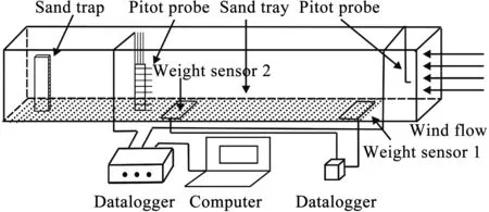
Figure 2 Layout of the test apparatus
To measure the wind-erosion rate,two weighing platforms were set up in this experiment.Each plat‐form area was 30cm×30cm,and the power supply was 24 V direct current.The measuring range was 0 g to 25,000 g,with a precision of 1 g;and the data-col‐lection interval was 1 s.Data recording was performed by a paperless recorder.Weighing platform 1(No.1)was placed at the front of the test section,recording the wind-erosion rate of the bed surface without the sand supply.Weighing platform 2(No.2)was placed in the middle of the test section,recording the winderosion rate of the bed surface under natural conditions.
In the experiment,the width of the gap between the periphery of the weighing sensor area and the bed surface was less than 2 mm.We quantified the impact of wind speed on the weighing sensor.The calculation methods were as follows.First,we placed a 500-g weight on the sensor and started the experiment.Dur‐ing the experiment run time,the weighing sensor con‐tinuously recorded data.Second,after the end of each group of experiments,we calculated the average val‐ue for this group according to the recorded data.We did three repetitions under each wind speed.After‐wards,we calculated the average value of the three tri‐als;and the average value indicated the influence of wind speed on the sensor.Third,we subtracted this value in the later data processing to eliminate the ef‐fects of wind speed on weight measurement.
The sand-transport rate was calculated according to the sand trap,which was invented at the Key Labo‐ratory of Desert and Desertification of the Cold and Arid Regions Environmental and Engineering Re‐search Institute of the Chinese Academy of Sciences.The sand trap had 50 nozzle orifices connected to 50 sand chambers.Each orifice was 1cm×1cm.The col‐lection efficiency of the sand collector ranged from 0.87 to 0.96 under different wind speeds,and the aver‐age value was 0.91(Donget al.,2004).The sand trap was placed at the end of the experimental section.At the end of the experiment,we weighed sand samples at each height,one by one,using an electronic bal‐ance.The accuracy of the electronic balance was with‐in 0.01 g.The original bed surface for the experiment was laid 6-m long,10-cm thick,and 1-m wide;and the original soil samples were refreshed after finish‐ing each experimental run to ensure the same initial conditions.
2.3 Data processing
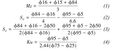
The particle sizes of samples were analyzed by a Mastersizer 2000(Malvern Co,Ltd.,UK;sample di‐ameter range,0.02-2,000 μm).The calculation for‐mula of average particle size(Mz),sorting(Sd),skew‐ness(Sk),and kurtosis(Ku)parameters of particles was according to Logarithmic Folk and Ward(1957)graphical measures.The calculation formulas were as follows.
3 Result
3.1 Aeolian transport characteristics
Table 1 shows the grain-size distribution of the natural surface.The mean diameter was 0.172 mm,standard deviation was 0.96 (moderately sorted),skewness was 0.34(very finely skewed),and kurtosis was 2.04(very leptokurtic).The surface was covered with medium sand,fine sand,very fine sand,and silt;and their volume percentages were 23.40%,35.85%,17.38%,and 12.18%,respectively.
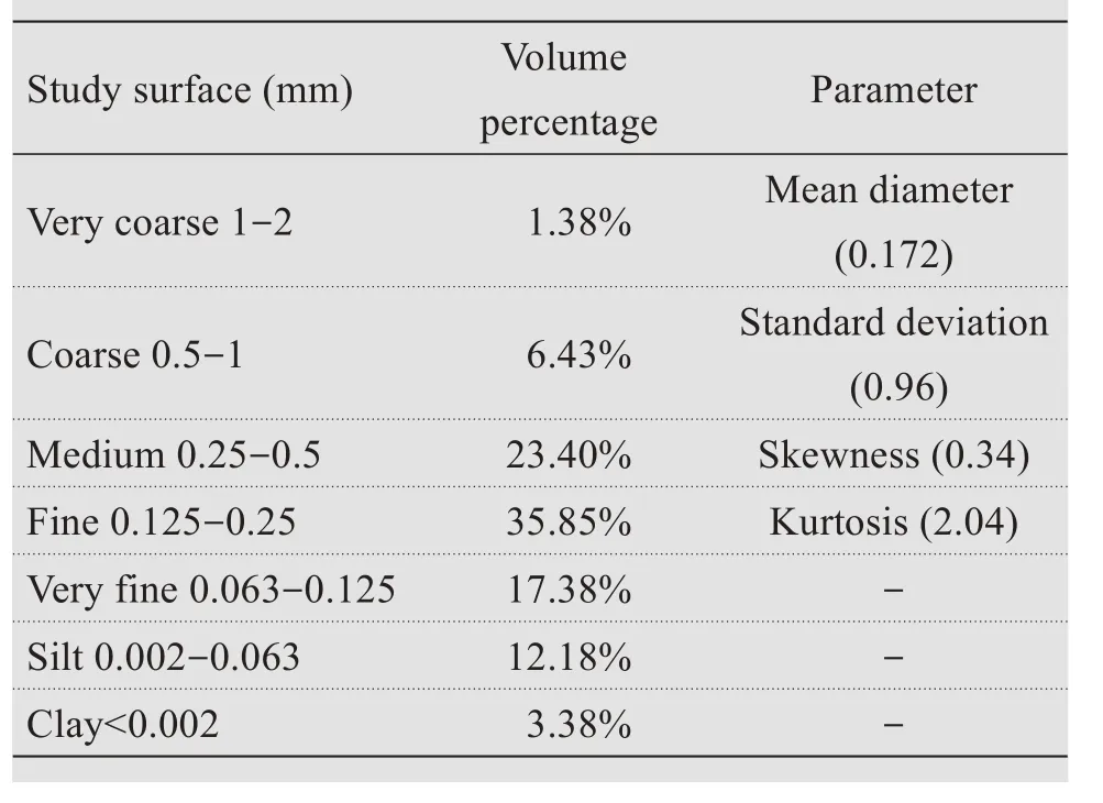
Table 1 Composition and parameters of the study surface and their volume percentages
Figure 3 and Table 2 are the fitting map and pa‐rameter table of sand transport rate and height,respec‐tively.Similar to previous research results(Donget al.,2004;Tanet al.,2014),an exponential relation‐ship between sand-transport rate and height presented,and the exponential relationship was not affected by wind speed.Further analysis showed that parameter A increased with wind speed,and parameter B decreased with wind speed(Equation(1)):

At height z,qzis the sand-transport rate;the unit is g/(cm·min).Zis the height,and the unit is mm.A and B are constants related to the initial wind speed.Table 2 shows that the regression relationship between sandtransport rate and height was very obvious,and the correlation coefficientR2was greater than 0.959.

Figure 3 The sand-flux profiles under different experimental wind speeds
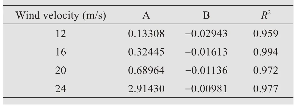
Table 2 Values of regression coefficients in Equation(1)
Three characteristic heights(h50,h75,and h90)cor‐responding to 50%,75%,and 90%of the cumulative percentage of the total transport rate were derived from the cumulative-percentage diagram(Figure 4).All three of the characteristic heights showed the ten‐dency of increasing with wind speed:for example,the heights ofh75at 12 m/s,16 m/s,20 m/s,and 24 m/s were 5.91,8.29,9.91,and 11.25 cm,respectively.Usually, the characteristic heighth50, representing the 50%cumulative percentage,was defined as the average saltation heightha(Zing,1953;Wu,1987).Figure 4 shows the heights ofh50at 12 m/s,16 m/s,20 m/s,and 24 m/s were 2.74,4.19,5.28,and 6.12 cm,respectively,implying that the blown sand particles reached higher above the surface as the wind velocity increased.
3.2 The processes of aeolian erosion over the alpine meadow
Figure 5 shows the process of aeolian erosion over the alpine meadows at wind speeds of 12 m/s,16 m/s,20 m/s and 24 m/s.The results reveal that the quantity of aeolian erosion increased linearly with the increasing experimental time and wind speed.For example,the quantities of aeolian erosion without sand supply over the alpine meadow ranged from 0 g to 60 g,and the aeolian erosion rate was 5.22 g/(m2·min)at a wind speed of 12 m/s(Figure 5a).The quantities of aeolian erosion were 120 g,300 g,and 550 g at wind speeds of 16 m/s,20 m/s,and 24 m/s,respectively.The corresponding aeolian ero‐sion rates were 10.67 g/(m2·min),148.63 g/(m2·min),and 833.41 g/(m2·min).This pattern indicates that the greater the wind speed and experimental time,the larger the amount of soil erosion and the aeolian rate.A summary of wind-erosion intensity and sand flux is shown in Figure 6.The results indicate close positive correlation between wind-erosion intensity and sand flux.At a relatively low wind speed(12-16 m/s),the average wind-erosion intensity of the two speeds is 7.95 g/(m2·min),with a mean sand flux of 1.12 g/(cm·min);whereas at the high wind velocities(20-24 m/s),these values increase to 491.02 g/(m2·min)and 15.92 g/(cm·min).
Combining the above results of erosion intensity and total mass sand flux under different wind speeds,we found that aeolian erosion intensity and sand flux were relatively low between 12 m/s and 16 m/s,while the above mentioned parameters ramped up very quickly between 20 m/s and 24 m/s,indicating strong aeolian erosion.

Figure 4 Selected cumulative-percentage diagram illustrating characteristic heights
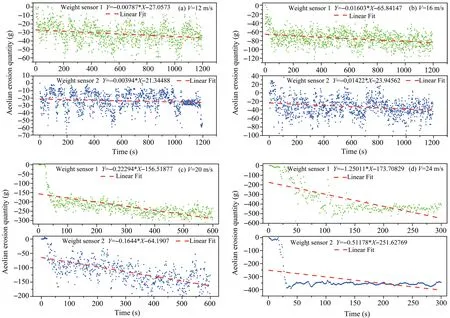
Figure 5 The process of aeolian erosion and deposition over the alpine meadow
3.3 Grain-size distribution with height
3.3.1 Grain-size frequency distribution
The sand-flux profiles of different grain-size groups with different wind speeds are shown in Fig‐ure 7.Results show that the mass flux of coarse sand,medium sand,fine sand,very fine sand,silt,and clay decayed exponentially with height at wind speeds of 12 m/s and 16 m/s,exhibiting the same curve shape as the total sand-flux profile in Figure 3.And the curve shape of medium sand could be fitted by an exponen‐tial equation with height at speed of 20 m/s,which proved that the sand flux decreased with height.But other size-grading curve shapes were evidently differ‐ent from the exponential decay distribution and could be expressed by Gaussian distribution functions,indi‐cating that the sand flux declined near the surface with increasing height.The inflection points in the profiles occurred at heights of 20-30 mm.Besides,at the speed of 24 m/s,all the profiles can be expressed by Gaussian distribution,too.The inflection points in the profiles occurred at heights of 30 mm except that for medium sand,which showed an inflection point of 20 mm.The height of the inflection point increased with increasing wind speed.
Figure 7c and Figure 7d show that the sand-flux profile could be divided into three sections:The first part(I)represents the near-surface layer,in which the saltating flux increased with height;the second part (II) represents an inflection point where the peak sand flux occurred,ranging from 20 to 30 mm in height,in which the height of inflection point de‐creased with the increase of sand-particle size and wind speed;the third part(III)refers to the layer where the flux mass density decayed exponentially with increasing height.

Figure 7 Sand-flux profiles of different grain-size groups under wind speeds of 12 m/s(a),16 m/s(b),20 m/s(c),and 24 m/s(d)
A summary of weight percentages of different grain sizes under different wind speeds is shown in Table 3.The results indicate that the fine-sediment fraction accounted for the maximum weight percent‐age without having a relationship with increasing wind speed,which was the same as the weight per‐centage of parent grain sizes.But the percentage was not the same as that for the natural surface sand,for example,the weight percentage of fine sand under 20 m/s was 41.46%.The others were 35.96%,41.06%,and 40.49%under 12 m/s,16 m/s,and 24 m/s,which gave more weight to the sand flux than the natural surface sand.The weight percentages of very fine sand and silt were both more than that for the natural surface sand,but the weight percentages of medium sand and coarse sand were smaller than for the natu‐ral surface sand.The reason was that the smaller the particle size,the more easily the particle was affect‐ed by the wind speed.The above statistical analyses indicated no significant positive correlation between wind velocity and the weight percentages of differ‐ent grain sizes,but they were dependent mainly on the composition of the natural surface materials at wind velocities between 12 m/s and 24 m/s.Further‐more,the particle-size fractions of the eroded materi‐als show that the aeolian process of alpine meadows not only transports the fine fractions from the crushed surface but also transports large quantities of the medium fractions.In addition,as surfaces are eroded,the fine sand,medium sand,and very fine sand might accumulate downwind to form sand sheets or dunes that would threaten human survival.Furthermore,the silt and clay might be involved in dust storms (Wang, 2004). Both outcomes could form the sand disaster and affected regional ecosys‐tems at the study site.
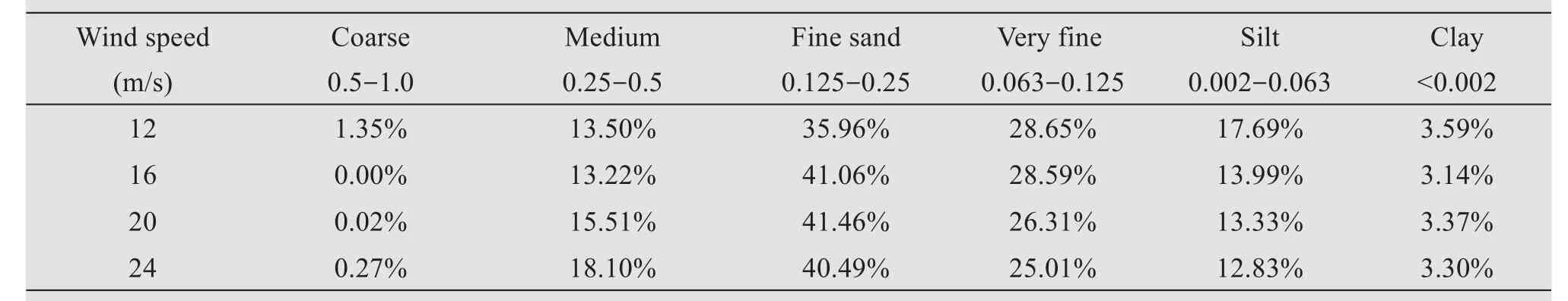
Table 3 The weight percentages of different grain sizes(in mm)under different wind speeds
3.3.2 Grain-size statistics
Figures 8a-8d show the calculated mean grain size,sorting,skewness,and kurtosis,respectively,in relation to transport height under different speeds.Grain-size parameters were determined using the geometric meth‐od of moments in gradistat software(Boltt and Pye,2001).Figure 8a reveals that the mean grain size de‐creased from a maximum value close to the surface un‐til a reversal trend in grain-size occurred,and the mean grain sizes then increased with height above the sur‐face.The inflection points in the mean grain-size pro‐file for 12 m/s,16 m/s,20 m/s,and 24 m/s occurred at heights of 80 mm,70 mm,70 mm,and 50 mm,respec‐tively.And with increasing wind velocity,the mean grain size increased.For example,the mean grain sizes were 0.102 mm,0.115 mm,0.125 mm,and 0.150 mm at the 70-mm height under 12 m/s,16 m/s,20 m/s,and 24 m/s,respectively.The variation tendency was con‐sistent with the result obtained by Tan(2014).With the protection of vegetation,the sand grain could not move easily with wind,so the wind-sand flow structure was in an unsaturated state.But the moving sand could get more energy and jump higher when colliding with veg‐etation;so the mean grain size increased with height,within limits.The sand samples collected at different heights ranged from moderately well sorted to moder‐ately sorted,except at the height of 10 mm under 12 m/s,according to the categorization of Blott and Pye(2001).There were no obvious changing trends be‐tween sorting and height(Figure 8b),which might be in relation to the character of the parent soil.But the sorting improved under the influence of wind.Figure 8c shows the relation between the skewness and height.All the sand samples at different heights be‐longed to the category of very finely skewed,which was similar to the natural surface sand.Meanwhile,the sand skewness at different heights increased with height at different wind speeds,except at 12 m/s.The variation trend of kurtosis with height was also analo‐gous to that of the natural surface sand and the varia‐tion tendency of skewness.All the samples collected at different heights belonged to the category of very lep‐tokurtic(Figure 8d),according to the categorization of Blott and Pye(2001).
In summary,the mean grain size was basically de‐creasing and then increasing with height under differ‐ent wind speeds.The sorting,kurtosis,and skewness fall into alignment with the characteristic of natural surface sand and had no relation with increasing height except that the sorting was better with increas‐ing height under different wind speeds.
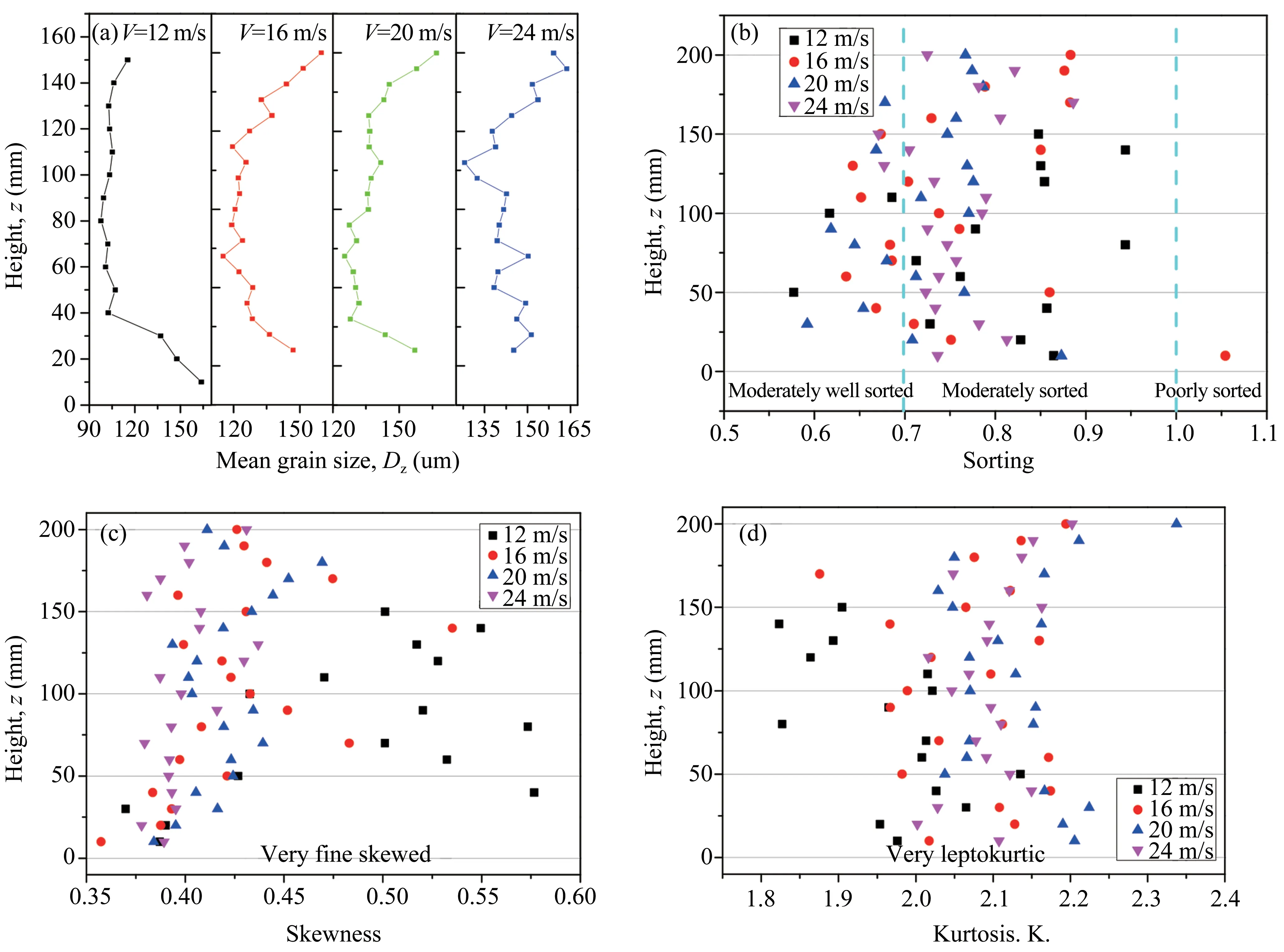
Figure 8 Mean grain size,sorting,skewness,and kurtosis changes with height at wind speeds of 12 m/s,16 m/s,20 m/s,and 24 m/s
4 Discussion
4.1 Sand-flux profile patterns
The blown-sand-flux profile over an alpine mead‐ow in this study has the same form as the exponential decay function proposed by Dong(2004)and Tan(2014)for the near-surface layer of particles of mixed sizes,based on wind tunnel tests and field observa‐tions.From our study,the percentage of sands finer than 0.1 mm in diameter is less,so that transport in suspension is negligible, according to Bagnold(1941).But there is a little difference between our re‐sults and those of Dong(2004).For a single-size grain group,our study suggests that the sand-flux pro‐file shows the exponential decay pattern or the peakflux-profile one.The Gaussian distribution is a better fitting curve than exponential distribution at wind speeds of 20 m/s and 24 m/s.The profiles of mass flux for fine sand,very fine sand,silt,and clay with increasing height have apparent inflection points.The profile pattern is similar to that of the sand-flux pro‐file over a gravel surface,which is also confirmed by previous field observations(Tan,2014)and numerical simulations(Shao,2005).From the results of previ‐ous studies such as Shao(2005),Tan(2014),Feng(2007;2009),and Bo(2013),the particle liftoff veloc‐ity and angle have obvious influence on the sand-flux profiles(Boet al.,2013).Modeling results of Shao(2005)and Feng(2007;2009)indicated that the simu‐lated vertical mass flux decayed exponentially with in‐creasing height for uniform-sized particles if the distri‐butions of liftoff velocity and angle are exponential and Gaussian distributions,respectively,while the pro‐file conforms to Gaussian distribution when the liftoff velocity and angle are Gaussian and exponential distri‐butions,respectively.Our wind tunnel experiment com‐bining these modeling results suggests that the liftoff velocity and angle for the wind speed of 12 m/s and 16 m/s for particles of different sizes are in exponential and Gaussian distributions,respectively;but for wind speeds of 20 m/s and 24 m/s,the particles'liftoff veloc‐ity and angle were in Gaussian and exponential distri‐butions,except for the medium sand.
4.2 The reason for sandy desertification of alpine meadows
Over past decades,temperature has increased ob‐viously and resulted in regional climate warming in high-latitude areas. According to Dong's results(Donget al.,2010),the mean annual temperature trend is 0.47°C per decade in Maqu County.Temperature in‐creases accelerated the regional desertification process(Xieet al.,2017a).The reasons are as follows.First,the temperature increases cause melting of the glaciers and increasing of air humidity,which enhances the physical weathering of the rocks.At night,the tempera‐ture drops,a large amount of water vapor condenses on the surface of the rock to form a muddy flow,and the rock near the crack is crushed into a block stone;and due to pressure,a finer substance is generated by the freezing expansion.During the daytime,the tempera‐ture rises;and the mud flow dissolves the debris mate‐rial.At last,the rocks fall apart.After the fissures form,the material finally merges into the river.Secondly,with the temperature increases,the glaciers begin to melt and cause the river runoff to increase,which en‐hances the erosion to the surface.So a large amount of weathered material and loose material is taken into the river and dissolved by wind and water flow,which in‐creases the sand source.Again,the faster the rate the temperature rises,the stronger the freeze-thaw effect is(Anet al.,2014).
In addition,unreasonable land-use patterns and overgrazing in the region are also important reasons for regional desertification(Donget al.,2010).In the process of land use,a large amount of turf is de‐stroyed;and the grassland becomes bare land,which is directly exposed to the wind.Excessive grazing causes the number of animals in the area to exceed the capacity of the grassland,causing grassland degra‐dation,reduced vegetation coverage,and ultimately desertification.
According to previous research results,air densi‐ty,sand-particle size,a sandy environment,soil-water content,and so on all have an impact on grassland de‐sertification(Donget al.,2010).Compared with lowaltitude grasslands,the elevation of alpine meadows is high,with lower air density and weaker carrying ca‐pacity and overall sand-transport rate (Hanet al.,2014). But the saltating sand grains reach greater heights at a high altitude than at a low altitude,and the kinetic energy of the sand is greater.So the colli‐sion and abrasion are strong.During the jump pro‐cess,collision and abrasion accelerate the physical de‐composition;and the density of the sand per unit of air increases,having a stronger destructive ability to alpine meadows(Zhanget al.,2010).Second,windy weather is frequent in the area;and the wind power is strong.When the sand leaps off the surfaces,its kinet‐ic energy gradually transforms into gravitational po‐tential energy;and the velocity gradually decreases(Chenget al.,2014).However,under the action of wind,the stagnating sand regains enough kinetic ener‐gy.So the energy carried by the sand itself increases during the jump process and releases when it falls to the ground again,which greatly enhances its ability to destroy meadows(Zhanget al.,2010).Third,the aver‐age particle size of the mixed sand is firstly reduced and then increased at high altitudes with increasing height.Under the same wind speed,the height of the coarse-grained component is higher than that of the low-altitude region;and the air-storage time is pro‐longed,allowing the particles to obtain more energy.When particles land on the table,the impact and de‐structive power to the surface are stronger.Moreover,the above-mentioned causes can produce a severe chain reaction and accelerate the desertification process of al‐pine meadows.Therefore,compared with effects upon meadows in low-altitude areas,the desertification of meadows in high-altitude areas is faster and more diffi‐cult to control(Xieet al.,2017b).
5 Conclusion
Wind tunnel data are provided on profiles of aeoli‐an sand flux and grain-size distribution under differ‐ent wind speeds over an alpine meadow to reveal its sandy desertification processes and mechanisms.The following conclusions can be drawn:
(1) In terms of sand-flux profiles of mix-sized sand,the sand flux of different heights at all the test speeds decreases exponentially with the increasing height.However,the sand flux of various uniformgrain-size groups and the distribution of the sand flux at different heights are different.Under the speeds of 12 m/s and 16 m/s,the sand flux of all uniform-grainsize groups can be expressed by exponential distribu‐tion.With the speed increasing,the distribution of finegrain sand can be better expressed by Gaussian func‐tion than by the exponential functions;and for various uniform-grain-size groups,the distribution changes to Gaussian function under the speed of 24 m/s.From the study results,the distribution can be divided into three layers with the increasing height.Within the first layer,the sand flux increases with the height.The second lay‐er is the inflection point,where peak sand flux occurs.The third layer is where the flux mass density decays exponentially with increasing height.
(2)The average saltation height has a relationship not only to sand size and wind speed but also to liftoff velocity and angle.The greater the speed,the higher the saltation height reaches.The saltation heights of mixed sand at speeds of 12 m/s,16 m/s,20 m/s,and 24 m/s are 2.74,4.19,5.28,and 6.12 cm,respectively.Therefore,the sand-protective engineering measures must be higher than 6.12 cm in the study area.But ae‐olian erosion is very strong if the wind speed is over 16 m/s.In light of this conclusion,the reinforcing pro‐tective engineering measures of an alpine meadow must be strengthened.
(3)The mean grain size of different heights basi‐cally decreases and then increases with increasing height under different wind speeds,and its distribu‐tion with height follows a Gaussian function.But the sorting,kurtosis,and skewness fall into alignment with the characteristics of natural surface sand and have no obvious relationship to increasing height ex‐cept that the sorting improves with increasing height,which is impacted by the wind.
Acknowledgments:
This research was supported by the national key re‐search and development project of China(Grant No.2017YFC0504801), the National Natural Sciences Foundation of China (Grant No. 41871016), and Opening Fund of Key Laboratory of Desert and De‐sertification, Chinese Academy of Sciences (Grant No.KLDD-2017-007).
 Sciences in Cold and Arid Regions2020年1期
- Sciences in Cold and Arid Regions的其它文章
- Characteristics of permafrost degradation in Northeast China and its ecological effects:A review
- A case study on Landscape Component Niche based on Landscape Pattern Indices:Yanchi,Ningxia Province,China
- Soil-moisture dynamics and tree-water status in a Picea crassifolia forest,Qilian Mountains,China
- Culturable bacterial diversity in hypolithic and peripheral soils in the west of the Hexi Corridor desert and its influencing factors