良渚古城,是怎样一座城

反山墓地。
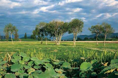
这片山林环绕之地,依山傍水,和中国江南水乡的风貌没有什么不同。
然而,一个实证中华五千年文明史的圣地,就掩埋于这片山林之下,华夏历史在这里改变。
它有一个动听的名字——良渚。
五千年前的良渚古城被称作“中华第一城”,内城面积近300万平方米,相当于4个故宫。她代表的不仅仅是一座城,而是一个古代王国。遥远的良渚时代,有一支训练有素的队伍,夜以继日地协力建设家国。
格局:三重向心式

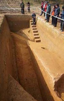
老虎岭水坝,专家在观察地层叠压关系。
良渚古城由4个相对独立的遗址片区组成,完整包含了良渚先民建造的规模宏大的城址、功能复杂的外围水利系统、层级复杂的分等级墓地和祭坛、以具有信仰与制度象征的系列玉器为代表的出土器物等人工遗存,以及与人工遗存具有直接关联的自然山水等历史环境要素。
古城采用三重向心式布局,最中心的是莫角山宫殿区,是整个古城的核心区;宫殿区外面是内城和外城。良渚古城的这一布局,与后世都城“宫城、皇城、郭城”的三重结构体系十分类似,是早期都城规划的典范。
古城是一座水城,由城墙围合而成,面积约3平方公里。城墙上发现9座城门,其中8座为水门。水门是城墙被河道隔开的地方。四通八达的水门,将城墙内外纵横交错的古河道串联起来,人员物资通过这里往来于城内城外。古城南部,这条今天被称为良渚港的主要河道,在这片土地上已经静静流淌了5000年。
在南城墙中部位置,墙体有一处明显的缺口,这里没有发现垫石和古河道的遗迹,是良渚古城的一处陆地城门。
除南城墙无外城河外,其余三面城墙均有内、外城河,形成夹河筑城的模式。城内、外河道经过水门相接,构成内外水网与水路交通体系。
内城:权力的中心
莫角山的宫殿
宫殿区位居古城中央,包括莫角山及其南侧的皇坟山、池中寺三处台地。面积约39公顷。

良渚古城遗址水门图。
莫角山台地呈矩形覆斗状,东西长670米、南北宽450米,面积约30公顷,是古城内体量最大的人工台地。
相对高度9米的台地顶面上建有大莫角山、小莫角山、乌龟山三座独立的宫殿台基,大面积夯筑而成的沙土广场,以及35座房屋基址,是良渚古国最高统治者的居住和活动场所。
考古发现,在莫角山宫殿区东面的钟家港古河道内,数根用于莫角山宫殿建造的大型木构件,可以想见当年那些建筑的宏大规模。
莫角山宫殿区位于整个古城的正中心,占据了古城1/10的面积,堪称中国最早的宫城,也是规模最大的史前宫殿区。
今天,站在大莫角山上,古城内外尽收眼底。天目山的余脉大雄山和大遮山,为古城提供了南北两道天然的屏障。大莫角山是整个宫殿区地势最高的地方,是城内的制高点,总面积有2万平方米,君临天下之感,扑面而来,这是王者或权贵才能拥有的统治者的视野,体现了王者居中居高的特点。
你可以把它想象成故宫的太和殿,太和殿的面积为1200多平方米。但5000年前,良渚人就已经能建造这么大的宫殿建筑。
遗憾的是,木结构建筑不易保存,辉煌的宫殿已经灰飞烟灭,但我们依旧可以感受到一个存在于5300年前到4300年前的古代王国,曾经何等辉煌。
莫角山西南的池中寺台地,经考古发现有超过10万公斤的炭化稻谷遗存,是良渚古城内大型粮仓的所在,反映出良渚古城的粮食储备和管理能力,以及当时城市的人口规模。
反山的王陵
古城内外分布着一些分等级墓地,其中最具代表性的有5处,它们分别是代表最高等级的反山、瑶山墓地,较高等级的姜家山墓地,中等级的文家山墓地和低等级的卞家山墓地。
这些分等级墓地与历年来环太湖地区陆续发现的其它良渚文化分等级墓地一起,构成了良渚社会高低悬殊、层级复杂的阶层分化,为良渚古国的出现,提供了社会分化方面的證据。
反山墓地是迄今所见良渚文化乃至整个中国史前文化中出土玉器数量最多、种类最为齐全的高等级墓地。它位于内城的西北部,东侧与莫角山宫殿区相邻,是一处依托其西部自然岗地人工特意堆筑形成的独立的高台墓地。墓地平面略呈椭圆形,人工堆筑的高度超过7米,面积约2公顷。
其中,反山12号墓位于墓地中央位置,该墓地出土的 “琮王”、“钺王” 、玉璧、豪华权杖的玉端饰、成组锥形器、三叉形器、环镯、管珠……等玉器,显露出墓主人的特殊身份。这是良渚文化等级规格最高的一处墓地,是良渚王的陵墓。王陵内现已发掘的11座墓葬规划有序,出土了1200余件玉、石、陶、象牙、漆器,其中玉器占90%。

瑶山祭坛垒石包边的拐角,整齐,结实。土台以下的山体也以石坎修整,呈阶梯状。当年的良渚人便从这里拾阶而上。
外城:平民的日常
古城的发展是动态的。随着人口的增加,城内的生活空间不够用了,为了扩大居住用地,人们在淤塞的河道上和城外的沼泽地继续堆筑黄土,形成新的生活区。
在内城的外围,17处长条形人工台地,断续链接,共同构成了“C形”的外城郭,构成了面积约351公顷的半封闭形态,今天称为外城。外城台地上分布着许多普通村落,有平民墓地、手工作坊和生活居住址等不同功能分区。
美人地遗址位于外城西面,地势低平。先民在下层堆筑青灰色淤泥,上层堆筑细密的黄土,其上再建筑房屋。这里发现的一排木板护坡遗迹,底部放置了垫木,防止下陷,再在垫木上竖立木板。
良渚先民临水而居,当时的河道两岸分布着成排房屋和临水码头,先民乘独木舟、竹筏穿梭其间。这种五千年前的江南景观,一直传承至今。
外城南部卞家山村落,是一处带有水岸码头的聚落,南部为生活居址。村落南侧临水,水岸边发现木桩140余个,分三排沿河岸有序排列,是栈桥的木桩。另一排木桩径直向水面伸展,是码头遗址的木桩基础。还发现有木桨,由此得知此处为良渚晚期的水埠及木构码头。
北部的卞家山墓地是典型的良渚平民墓地,共发现了墓葬 66 座,墓中随葬品平均不超过10件。文家山墓地,是一处不同等级墓葬同存的中等级家族墓地,遗址中还出土有不少石器制作过程中产生的废弃物,表明附近应有石器加工作坊。
城郊的祭坛
古城东北部的郊区约5公里处是瑶山墓地。这是一处高等级墓地,具有坛墓一体的结构特征。
在现存的瑶山顶部,没有发现生活遗迹或遗物,红土台、灰土围沟、砾石面等遗迹边壁平齐,转角方正,布局规整,连围沟内的灰色填土,也是特意从山外搬运来的。可见,这是一项经过精心设计、认真施工、具有特定用途的建筑。瑶山遗址,比古城、水坝营建的时间都要早。
实测发现,日出的方向与祭坛四角所指方位惊人一致。可见,当年良渚人在这里进行庄严的仪式,也观测星象。
祭坛废弃之后,变成了埋葬贵族的高等级墓地,13座大墓,C位11号墓葬的是良渚王的女人——良渚王后。
在瑶山墓葬的玉器中,发现了完整的神人兽面像,这是良渚人唯一的LOGO。图案上部,是头戴“介”字形羽冠的人的形象,下部是圆圆的眼睛、露出獠牙的猛兽的面目,下肢作蹲踞状,还有飞禽的利爪。这是良渚部族崇拜的“神徽”。
另外,在良渚古城郊区,还有许多建在水边低地的普通聚落,体现了当时社会已出现了明显的城乡分界,庙前遗址就是其中之一。这里发现了多处房址、墓葬、窖穴、木构水井等遗迹。
水利:中国第一坝
中华文明几千年的历史,从某种意义上说就是一部治水史。

良渚古城反山王陵。
据记载,新中国成立前2155年间,中国发生较大洪水灾害1092次;黄河在历史上曾决口泛滥1500多次。
先于“大禹治水”近千年,良渚水利系统是中国迄今发现的最早的大型水利工程遗址,也是世界上迄今发现的最早的堤坝系统之一。
良渚地处太湖平原,位于暴雨中心,海拔仅2米多高,易发洪涝灾害。良渚古城外围有大型多功能水利系统,是古城规划的重要组成部分。
水利系统位于古城西北,由谷口高坝、平原低坝、山前长堤与自然丘陵围合而成,规划有致,规模宏大,叹为观止。
谷口高坝发现的6条水坝,分东西两组,东组包括岗公岭、老虎岭、周家畈,西组包括秋坞、石坞、蜜蜂垄,每组各自封堵一个较高山体中的较大谷口。
平原低壩发现狮子山、鲤鱼山、官山、梧桐弄4条堤坝,并通过自然岗地与山前长堤连接成一体。山前长堤长约5公里,是水利系统中最大的单体遗存。
整个水利系统东西两端相距11公里,南北相距5.5公里,总占地面积76.2公顷。
堤坝有效保护良渚古城及周边稻田不受直接冲击。防洪的同时,能够在山谷高地和平原低地内进行蓄水。
大量水资源的存蓄,形成连接多个山谷的水运网络,起到调节河道水位的作用,为古城的水运交通和日常用水提供保障。同时,来自于天目山的丰富石料、木材,以及动植物等资源,可以通过水路运输到达古城。
Liangzhu:Chinas Number One City 5,000 Years Ago
The ancient Liangzhu City is now considered Chinas number once city five thousand years ago. The Inner City which includes the palace area measures nearly 3 million square meters, four times the Forbidden City, the magnificent palace complex of the Ming and the Qing dynasties in Beijing. The Liangzhu City is more than an urban center. It represents an ancient state. Archaeological evidences indicate that the grand city was constructed on the basis of a well-conceived plan over a long time and by a large number of people well trained and well coordinated.

良渚古城區域分布图。
1.City Layout:
Centripetal Triple Format
The Liangzhu City comprises four relatively separate sites, which combine to the city site, the peripheral water conservancy system, graded cemeteries and altars, a system of jade artifacts that present power and faith, and the environment of river networks and adjacent mountains which were closely associated with the city itself.
The city adopts a centripetal triple format. In the very heart of the city is the palace complex. The Inner City encircles the palace complex and the Outer City surrounds the Inner City. As this centripetal triple format can be seen in many subsequent capital cities of dynasties in Chinese history, the ancient Liangzhu City can be considered the prototype of early urban planning for construction of a capital.
The walled Liangzhu City is protected by water. The city is accessed by eight water gates and one land gate. The water gates connect a complex of watercourses within and without, conducive to the transportation of people and goods. Liangzhugang, a local river to the south of the site of the ancient city, has existed for more than 5,000 years. In the center of the southern section of the city wall is an opening where no trace of foundation rocks and ancient watercourse can be detected. Apparently the opening is a land gate. The southern city wall doesnt stand in water. The other three sides of the city wall are all flanked by rivers on the either side. The rivers form a network that connects the inside and the outside.
2.Inner City: Center of Power
The palace complex is in the very center of the ancient city including Mojiaoshan, Huangfenshan and Chizhongsi, three terraces that add up to about 390,000 square meters in area. The Mojiaoshan terrace accounts for the one tenth of the ancient city. It is Chinas most ancient palace site and biggest prehistoric palace complex.
To the north and the south stands Daxiong Mountain and Dazhe Mountain, part of the Tianmu Mountain Range. The two mountains form a natural protection to shelter the capital city of Liangzhu. The 20,000-square-meter Big Mojiaoshan is the tallest place in the city from where the supreme ruler could have a commanding view of his state. From this place one could imagine the magnificent ancient state that flourished for ten centuries from 5,300 to 4,300 years ago.
The Chizhongsi Terrace, to the southwest of Mojiaoshan, is home to a large-scale granary, as evidenced by 100,000 kilograms of charred rice found there by archaeologists. The granary and its scale enable people of today to take a look at the cereal storage and administration and the population within the city of that time.
Fanshan Royal Cemetery

紅土台。
There are graded cemeteries within and without the ancient capital city of Liangzhu. Five cemeteries are singled out of the cemeteries to represent the social hierarchy of the Liangzhu society. The Fanshan and Yaoshan cemeteries are sacred places for the highest class of the society. The Jiangjiashan cemetery is for nobles. The Wenjiashan cemetery and the Bianjiashan cemetery respectively cater to the middle and low classes of the Liangzhu society.
These cemeteries as well as those unearthed in recent years around the Taihu Lake area combine to constitute a social hierarchy of the Liangzhu state. The cemeteries are material evidence of the social differentiation five thousand years ago.
The Fanshan cemetery is a top-class graveyard which yielded the largest quantity of jade artifacts, which can be categorized into a complete system. Such a large quantity of jades in such a complete system has never been seen anywhere else in prehistoric China. Located in the northwest of the Inner City and next to the Mojiaoshan Palace Complex, the cemetery spread on a 7-meter-tall and 20,000-square-meter manmade terrace. The royal status of the dead buried in Tomb 12 is corroborated by a large galaxy of top jade artifacts. No other tombs unearthed so far in Liangzhu yielded such supremely-made grave goods. Archaeologists agree that buried in the tomb is the supreme ruler of Liangzhu State.
3.Outer City:
Commoners Everyday Life
The Outer City is composed of 17 manmade long terraces which are arrayed in the shape of C. The semi-closed area is now known as the Outer City, home to many settlements with cemeteries, handicraft workshops and living quarters. All the settlements are located by rivers. Rows of houses and docks flank a river and local residents move around by canoe. Such a lifestyle can still be seen today in Jiangnan, a vast region in the south of the Yangtze River Delta.
The settlement at Bianjiashan in the south of the Outer City is typical of the living arrangement. The south of the settlement borders the river. Three rows of wood piles stand orderly along the riverside. The wooden piles support a trestle bridge. One row of wood piles extends into the river. This row of wood piles supports a pier where goods are loaded and unloaded. The cemetery attached to this settlement has 66 tombs. Burial objects from these tombs average fewer than 10 per tomb and the burial objects differentiate men and women. It was a cemetery of low-class commoners. The Wenjiashan cemetery is a middle-class cemetery where people from different classes are somewhat mixed.
4.Suburban Altars
At the Yaoshan Site, 5 kilometers northeast of the city, is a top-class cemetery. The site holds a cemetery and an altar. The top of Yaoshan shows no sign of anybody ever living there. A truncated-pyramid-shaped altar formed of three earthen circles varied in color and surrounded by a stone revetment. Atop the altar are 12 large-sized Liangzhu Culture tombs similar to those discovered at Fanshan. The Yaoshan Site is a manmade structure, which is much older than the capital city and the dam system. When it was first made, it served as an altar. It probably also served as an astronomical observation platform. After the site was scrapped as an altar, it became a cemetery. Of the unearthed jade objects is a piece adorned with a sacred human and animal face motif, which is considered the logo of the Liangzhu Culture.
In relatively remote suburbs of Liangzhu City are many settlements in riverside lowlands, portraying the distinct urban-rural divide of the society. The Miaoqian Site is such a low-grade settlement where houses, tombs, underground storages and wood-structured wells are found.
5.The Water Conservancy System: Number One Dam of ancient China
It is said that the history of China of several thousand years is a history of water control. Historical records show that during 2,155 years before 1949, flood disasters on large scale occurred 1,092 times and that the dikes of the Yellow River burst more than 1,500 times. The water conservancy system excavated in Liangzhu is about 1,000 years older than the flood control project carried out by the legendary Yu the Great. The water control system of the Liangzhu Culture is Chinas earliest large-scale water conservancy engineering undertaking and one of the worlds earliest dam systems.
Located in the Taihu Lake Plain and just 2 meters above sea level, Liangzhu could easily fall a victim to floods. The capital city of Liangzhu is surrounded by a large-scale multifunctional water conservancy system, which is a key component of the urban planning of Liangzhu.

莫角山宮殿区。
Situated to the northwest of the city, the system comprises high-dams at the mouth of the valley, low-dams on the plain, causeways in front of mountains, and the natural foothills. They form a closed water-control system, presenting an elaborate and amazing planning and engineering.
There are six high-dams at the mouth of the valley. The six dams are in two separate sets, each blocking a valley. On the plain are four low dams connected with causeways. The total length is 5 kilometers, the largest single structure in the system.
The water conservancy system stretches 11 kilometers from east to west and 5.5 kilometers from south to north. The dams effectively protect the city and the rice farmlands from the direct onslaught of floods issued from the mountains. The water conservancy system also functions as a reservoir, which in turn adjusts the water level of the river network. The system ensures daily water supply for the city and makes it possible for stone and timber and other mountain resources shipped out to the city from the Tianmu Mountain Range.

