
Vulnerability and adaptation of an oasis social–ecological system affected by glacier change in an arid region of northwestern China
2019-03-14 01:49:58JianPingYangManLiChunPingTanHongJuChenQinJi
JianPing Yang, Man Li, ChunPing Tan, HongJu Chen, Qin Ji
1. State Key Laboratory of Cryospheric Sciences, Cold and Arid Regions Environmental and Engineering Research Institute, Chinese Academy of Sciences, Lanzhou, Gansu 730000, China
2. School of Geography Sciences, Shanxi Normal University, Linfen, Shanxi 041000, China
3. Institute for Disaster Management and Reconstruction, Sichuan University, Chengdu, Sichuan 610200, China
4. Key Laboratory of Mountain Hazards and Earth Surface Process, Institute of Mountain Hazards and Environment,Chinese Academy of Sciences, Chengdu, Sichuan 610041, China
5. University of Chinese Academy of Sciences, Beijing 100049, China
ABSTRACT The Hexi Inland River Basin in an arid region of northwestern China was chosen as the study area for this research. The authors define the vulnerability of an oasis social-ecological system to glacier change; select 16 indicators from natural and socioeconomic systems according to exposure, sensitivity, and adaptive capacity; and construct a vulnerability-assessment indicator system aimed at an inland river basin in the arid region of Northwestern China. Vulnerability of the oasis socialecological system affected by glacier change in the study area is evaluated by Spatial Principal Component Analysis(SPCA) under the circumstance of glacier change. The key factors affecting the vulnerability are analyzed. The vulnerability of the oasis social-ecological system in the Hexi Inland River Basin affected by glacier change is of more than medium grade, accounting for about 48.0% of the total number of counties in the study area. In terms of the spatial pattern of the vulnerability, the oasis economic belt is the most vulnerable. With the rapid development of the area's society and economy, the exposure of the system to glacial changes is significantly increased; and an increase in glacial meltwater is not enough to overcome the impact of increased exposure, which is the main reason for the high vulnerability. Based on the result of the vulnerability analysis and combined with the present industrial structure in the Hexi Inland River Basin, near-,medium-, and long-term adaptation initiatives are put forward in the article.
Keywords: oasis social-ecological system; Hexi Inland river basins; glacier change; vulnerability; adaptation
1 Introduction
Mountain glaciers and ice caps cover 734,400 km2on Earth (Gardner et al., 2013). Glacierized mountains are often referred to as our world's water towers because glaciers both store water over time and regulate seasonal streamflow, releasing runoff during dry seasons when societies most need water (Carey et al.,2017). Glacier retreat generates far-reaching concerns about water supplies for communities in and around the world's glacierized mountains (Intergovernmental Panel on Climate Change, 2014). In the near term,glacier melting can give rise to an increase in river flow, which is generally beneficial. The flow,however, will decrease rapidly with further loss of glacial ice (e.g., Braun et al., 2000; Jansson et al.,2003; Radić and Hock, 2014). The ongoing glacier retreat has important implications for downstream river flows, regional water supplies, sustainability of aquatic ecosystems, and hydropower generation (e.g., Immerzeel et al., 2010; Kaser et al., 2010; Huss, 2011).Despite the possible human impacts from shrinking glaciers, most studies focus primarily on the hydrological effects of glacier changes on downstream societies; and the studies on the people and societies in glacierized watersheds is still very limited (Carey et al.,2017). At present, all over the world, study of the impacts of glacial changes on human society is mainly concentrated in the Andes, Alps, Great Himalayas,North Cascade, and Alaska. The existing research efforts mainly include these aspects: (1) socioeconomic impacts on local livelihoods, urban water supplies,mountain tourism, etc. (e.g., Vergara et al., 2007;Beniston, 2012; French et al., 2015; Konchar et al.,2015); (2) hydropower (e.g., Terrier et al., 2011;Bavay et al., 2013; Beniston and Stoffel, 2014), (3) irrigation, agriculture, and food security (e.g., Immerzeel et al., 2010; Nolin et al., 2010; Carey et al.,2014); and (4) cultural impacts (e.g., Paerregaard,2013; Boelens, 2014; Allison, 2015; Konchar et al.,2015). The four above-mentioned aspects study human impacts of glacier change from the perspective of the glacier and its runoff change. At present, assessment of the vulnerability of socioeconomic systems affected by glacier change and related adaptation are fewer in number.
In China, as early as 2007, scientists were acutely aware that the natural processes of cryospheric change would have a significant impact on regional social and economic development in the study of the cryosphere, which is primarily comprised of glaciers,frozen ground (including permafrost), and snow cover in China. How to link the natural processes of cryospheric change with its impact on sustainable social development has become a focus and core issue. So the projects "Cryospheric Processes in China and their Climatic, Hydrologic and Ecologic Effects and Adaptation (2007–2011)", "Cryosphere Change in the Northern Hemisphere and its Impacts on the Climate Environment and Adaptation (2010–2014)", and"Study on Cryosphere Change and its Impacts(2013–2017)" were launched, with successive grants since 2007 from the National Basic Research Program of China (973 Program) and the Major Scientific Research Program for Global Change. In the context of the ongoing warming of the global climate,natural processes, socioeconomic impacts, and risks and adaptation mechanisms of cryospheric changes have been developed, from theoretical exploration to practical research, in a comprehensive way in China(Qin and Ding, 2009; Ding and Xiao, 2013; Wang et al., 2015a,b; Yang et al., 2015a; Wang and Wang,2017; Qin et al., 2018).
The arid region, distributed in Northwestern China, covers 271×104km2, accounting for 28.2% of China's land area (Zhang et al., 2012). Though annual precipitation in the arid region is less than 250 mm,there are still many oases there, distributed in the middle and lower reaches of the inland river watershed. Some 22,086 glaciers and their meltwater in mountainous areas support the existence of these oases with their water supply (Zhang et al., 2012).Because the oasis socioeconomic development in the arid region is mainly dependent on mountain-glacier water resources, changes in the glaciers and their runoff have been of great concern to the Central and local governments, especially since the launch of "the Belt and Road (B&R)" initiative in 2013. Consequently, the inland river watersheds in the arid region of Northwestern China are one of the important study regions in the research field of the Chinese cryosphere. This article takes the Hexi Inland River watershed as a case area. In this study, the authors don't care about the changes of glaciers and their meltwater runoff in the study area, from the perspective of human society, they assess the vulnerability of the oasis socio-ecological system affected by glacier change, reveal key factors resulting in the vulnerability, and seek measures and approaches to adapt to glacier change.
2 Study area
2.1 Natural and socioeconomic situations
The Hexi Inland area is located in the eastern part of the arid region of northwestern China, between 37°17′N–42°48′N and 93°23′E–104°12′E in geography, with an area of 27.11×10⁴km2, accounting for 60% of the land area of China's Gansu Province(Lan et al., 2003). The climate is dry in this area. Annual precipitation ranges from 40 mm to 400 mm, and annual evaporation reaches 1,500 mm to 3,000 mm(Lin et al., 2014). Influenced by topography, the Hexi area is divided into three river systems: the Shiyang River, the Heihe River, and the Shule River systems in turn, from east to west; in total, 57 inland rivers,most of which originate in the Qilian Mountains(Figure 1). The climate in these three river basins is described in Table 1.
There are 2,444 glaciers in the Hexi Inland River area, with a total area of 1,596 km2, ice reserves of 785.18×10⁸m3, distributed in the Qilian Mountains in the south of the Hexi area (Yang, 1991). The number of glaciers is 141, 1,078, and 1,225 in the Shiyang,Heihe, and Shule rivers systems, respectively (Table 1).Glacier meltwater is a very important water supply in the Hexi Inland River watershed, on average accounting for 14.1% of the total river runoff in the entire Hexi area (Gao et al., 2011). In the three river systems, however, the ratio of glacier meltwater to river runoff is different: 3.76% in the Shiyang River system, 8.2% in the whole Heihe River system, and 32.8% in the Shule River system (Table 1). Administrative divisions in the Hexi region are the cities of Wuwei and Jinchang in the Shiyang River Basin; the cities of Zhangye and Jiayuguan in the Suzhou district of Jiuquan City in the Heihe River Basin; and Guazhou, Subei, and Akesai counties, and the cities of Yumen and Dunhuang in the Shule River Basin(Figure 1). The region is a densely populated oasis area, with a total population of 4.71 million people in 2012, based on the data of the Gansu provincial statistical yearbook (Table 1), accounting for 18.3% of the total population of Gansu Province. Among the three river basins, the population is 2.28, 2.00, and 0.43 million people in the Shiyang, Heihe, and Shule rivers areas, respectively. The majority of these inhabitants are distributed in Wuwei, Zhangye, Jiuquan,and Dunhuang oases. Oasis agriculture, mainly relying on irrigation by precipitation and glacial meltwater originating from the Qilian Mountains, is not only a staple industry in the Hexi area but also guarantees a source of food security in Gansu Province.The total agricultural value in this area is 33% that of the whole Gansu provincial agriculture. The Hexi area is also the main passageway of the "Land Silk Road Economic Belt", which is "One Belt" in "B&R". The area is being built into an important new energy base(wind and solar energy) and a characteristic economic corridor of dry farming and water-saving agriculture.
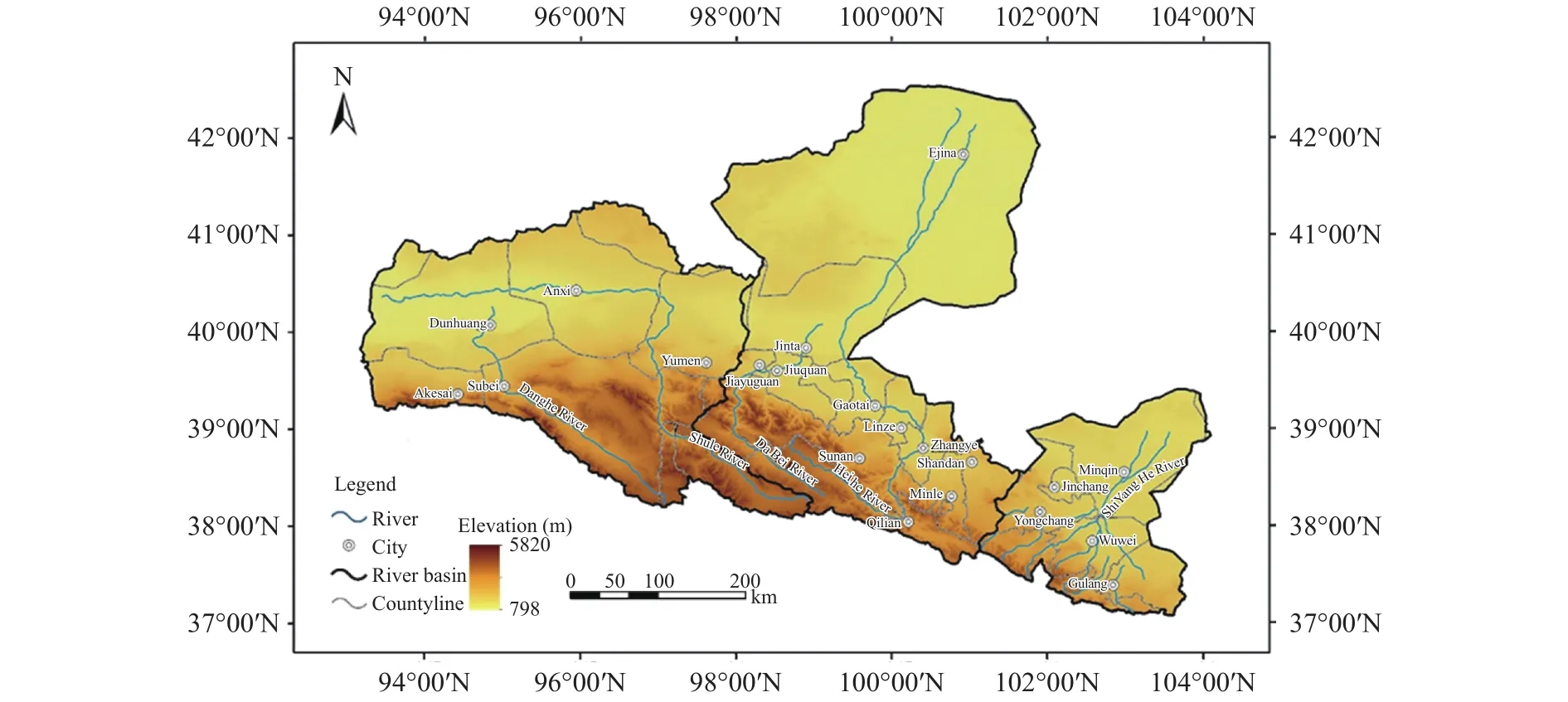
Figure 1 Geographical administrative divisions in the Hexi Inland River Basin and the distribution of its river systems
2.2 Changes in the glaciers and meltwater runoff in the Hexi Inland River Basin
The temperature in the Qilian Mountains increased significantly after the mid-1980s; and climatic warming has accelerated since the 1990s, with a rise of 0.27 °C/10a to 0.33 °C/10a for the annual mean air temperature, while precipitation increased slightly,in fluctuations, but not significantly (Jia et al., 2008).Because of the significant increase in temperature,glaciers in the Hexi Inland River Basin significantly shrank over the past decades (Gao et al., 2011; Wang et al., 2011). The total area of 335 glaciers studied declined about 29.6% in the Heihe River Basin from the 1950s/1970s to 2003 (Wang et al., 2011); and 866 glaciers studied decreased by 10.3% in the Shule River Basin during the period 1956–1990 (Liu et al.,2002). As a result, glacial meltwater runoff correspondingly increased in recent years. The annual average glacial meltwater in the whole Hexi Inland River Basin was 10.2×10⁸m3during the 1961–2006 period,reaching 14.8×10⁸m3between 2000 and 2006, 45.5%above the multi-annual average (Gao et al., 2011).The increase in glacier meltwater resulted in the marked increase of the river streamflow in the Heihe and Shule rivers basins (Lan et al., 2003; Yang et al.,2017). However, glacier meltwater runoff may not sustain the increase. It would be expected to fall after reaching an inflection point with the melting of glacier ice. Under RCP2.6 and RCP4.5 scenarios, the inflection point of glacier runoff has already appeared in the Shiyang Rivers Basin and will appear in the Heihe and Shule River basins in 2020–2030, based on the results simulated by the Cryosphere Basin Hydrology Model (CBHM), which is a hydrological model suitable for high-altitude cold regions in China (Chen et al., 2018). Mountain runoff has continuously decreased in the Shiyang River Basin since the 1950s(Lan et al., 2003); and the water supply is already critically low, but the demand could be intense. The glacier runoff will decrease sharply in the Heihe and Shule River basins after 2020–2030 (Chen et al.,2018). The glaciers' rapid retreat and people's longing for them has already resulted in a water crisis in the Hexi Inland River Basin, which is expected to intensify.
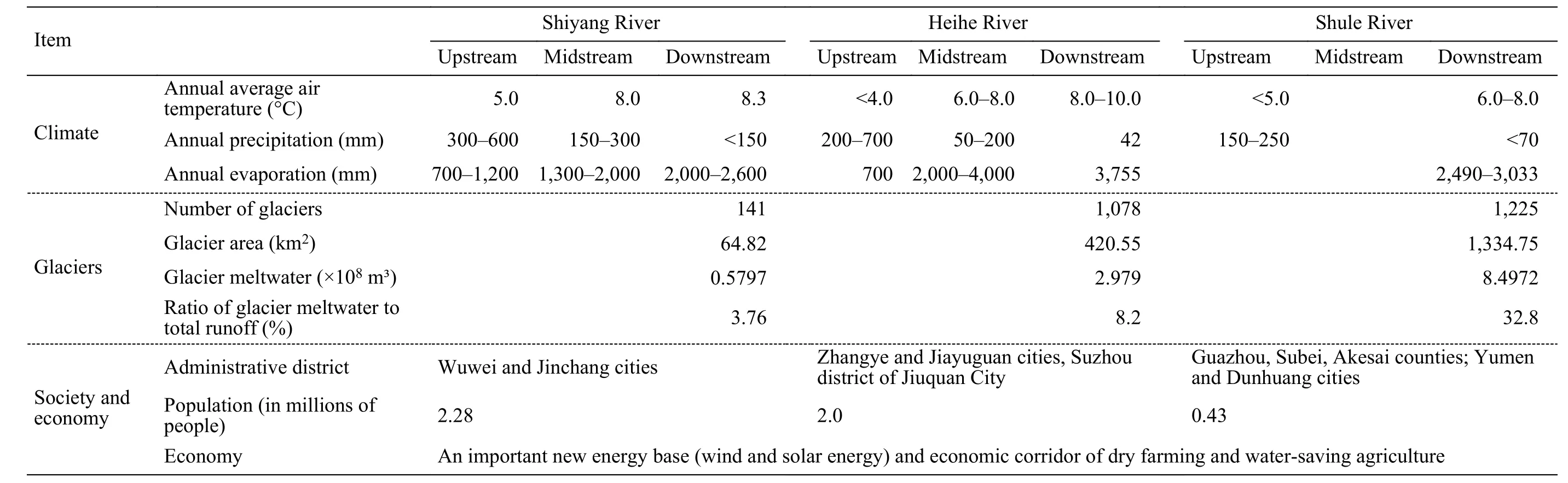
Table 1 General conditions in the Hexi Inland River watershed in the eastern part of the arid region of northwestern China
3 Data and methods
3.1 Data and its sources
3.1.1 Administrative division data
The data of the administrative divisions are based on the vector data set of 1:4,000,000 county-level administrative divisions in China. The geographical coordinate system is GCS-Klasovaky. The projection system is Albers projection, which comes from a surveying and mapping scientific database.
3.1.2 DEM data
DEM data is from the Western China Environmental and Ecological Science Data Center (http://westdc.westgis.ac.cn).
3.1.3 Meteorological data
The meteorological observational data, including annual evaporation and annual precipitation at 20 meteorological stations (Table 2); all come from the National Meteorological Information Center of the China Meteorological Administration. The time series are from 1995 to 2010.
3.1.4 Runoff data
Mountain runoff data are station observations from 1995 to 2010 (Table 3); the data of glacier meltwater in the same period are the simulated values of the VIC model from Gao (2010) in the Shiyang,Heihe and Shule rivers basins with an annual temporal resolution.

Table 2 Meteorological stations used and their details in the Hexi Inland area
3.1.5 Social and economic data
Social and economic data used in this article originated from all county and city statistical yearbooks in the Hexi Inland river basins during the period 1995–2010. In addition, the data of the water-resources bulletin, the annual report of water-conservancy management, the water-resources allocation scheme, etc., are also used in the study area.
3.1.6 Net Primary Productivity data
Net primary productivity (NPP) data is calculated by the BIOME-BGC model using the MOD17A3 product provided by the EOS/MODIS sensor of National Aeronautics and Space Administration/NASA.Its spatial resolution is 1 km, and the time-series is 2000–2010.
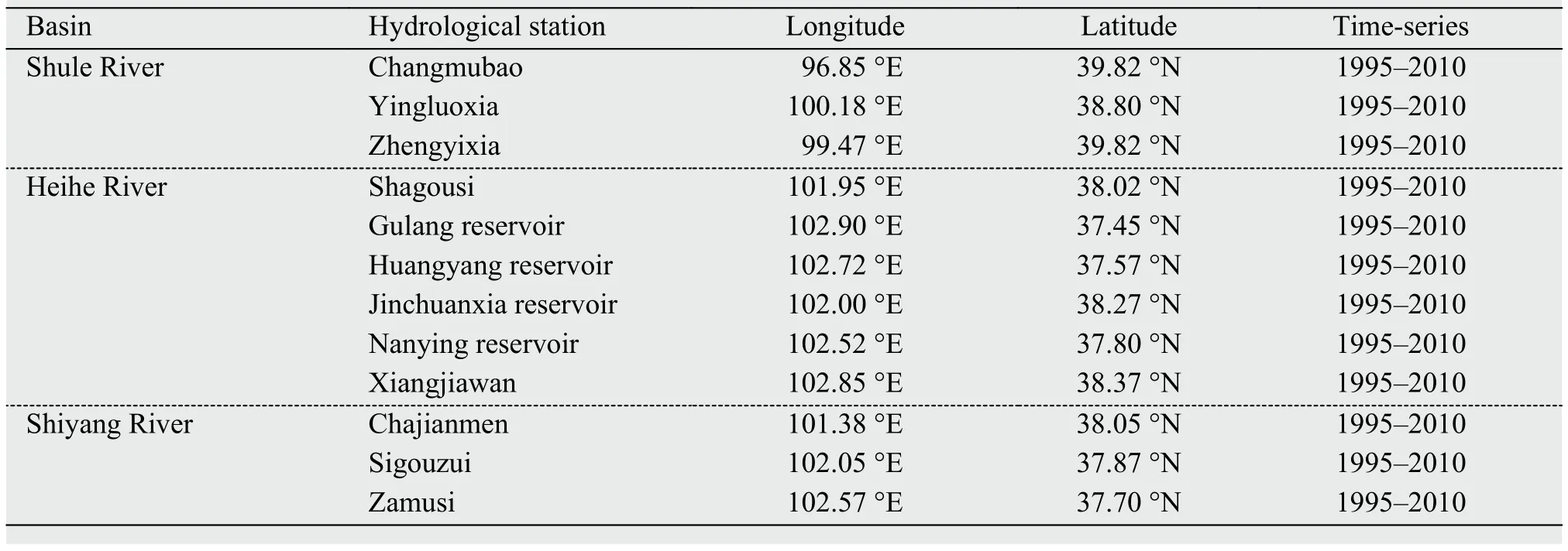
Table 3 Hydrological stations and their details in the Hexi Inland area
3.2 Data processing methods
3.2.1 Calculation method of aridity
Aridity index is an indicator of the degree of dryness and humidity in a region, expressed by water budget and heat balance in a certain area. It is calculated from (Meng et al., 2004; Wang et al., 2008):

where D is aridity index, PE is annual probable evaporation (Unit: mm), and P is annual precipitation(Unit: mm). The greater the aridity index in a certain area, the drier the climate is; conversely, the less the aridity, the wetter the climate is.
3.2.2 Processing method of NPP
The NPP grid maps of 2000 to 2010 covering the study area are first selected, and Modis Projection Tools (MPT) software is used to splice it year by year.At the same time, the output image-projection system is set up as Albers projection, and then the NPP data in each year are exported by HDFView software to generate the text files separately. The total annual NPP is calculated under the MATLAB language environment, and then the text files of the total annual NPP are imported to generate the raster data of 1-km resolution using conversion tools in ArcMap. Finally,the grid layer of the total annual NPP in the study area is cut out using the administrative boundary map and superimposed with the map of county administrative divisions; and the average annual NPP of each county is obtained statistically.
3.3 Construction of the vulnerability-evaluation index system in the inland river basin affected by glacier change
The vulnerability of the oasis social-ecological system to glacier change is the degree to which the oasis system is susceptible to adverse effects of glacier change. This vulnerability is a function of the character, magnitude, and rate of glacier change to which the oasis system is exposed, its sensitivity, and its adaptive capacity (Yang and Zhang, 2010). Exposure is the presence of people; livelihoods; environmental services and resources; infrastructure; or economic,social, or cultural assets in places that could be adversely affected by glacier change (Ding and Yang,2018). Sensitivity refers to the extent to which the oasis social-ecological system is affected by glacier changes (Ding and Yang, 2018). Adaptation capacity is the combination of the strengths, attributes, and resources available to an individual, community, society, or organization that can be used to prepare for and undertake actions to reduce adverse impacts of glacier change, moderate harm, or exploit beneficial opportunities (Ding and Yang, 2018). Based on the above concepts and the established vulnerability-assessment index system of the social and ecological systems affected by China's cryospheric change (Ding and Yang, 2018), combined with the actual situation in the Hexi Inland River Basin and data availability,the vulnerability-evaluation index system of the inland river basin affected by glacier change was constructed (Table 4). The system consists of an objective layer, standard layer, and indicator layer. Exposure, sensitivity, and adaptive capacity, which are the three elements of vulnerability, are regarded as the criteria for selecting indicators. The criteria are further subdivided into six aspects―the exposure of natural and socioeconomic systems; the sensitivity of the socioeconomic system to glacier-change impact; and ecological, economic, and social adaptive capacities(Table 4).
The runoff per unit oasis area, glacial meltwaterrecharge rate, aridity index, and area in oasis—these four indicators depict the natural exposure of the social-ecological system in the study area. Regional GDP (gross domestic product), population density,and urbanization rate are selected to characterize the social and economic exposure of the system. In the Hexi Inland River Basin, water resources are mainly used for agricultural production. Agricultural water use accounts for about 90% of the total water consumption of the basin. After the surface runoff comes out of the mountain, it is directly introduced into farmland through a main canal, branch canal, bucket canal, and sublateral canal. Therefore, the change in glacial meltwater runoff mainly influences agriculture, in turn affecting overall economic development.Based on the practical situation of water use in the basin, the change in glacial meltwater-recharge rate,total grain yield, and GDP output per unit of water is selected to characterize the sensitivity of the oasis system to glacier change. According to the regional characteristics of the Hexi Inland River Basin and data availability, the article selects net primary productivity (NPP), labor productivity, the proportion of high-water-consumption industry, the output value of the tertiary industry, the number of persons receiving nine-year compulsory education, and Engel's coefficient to reflect the ecological, economic, and social adaptive capacity of the oasis system (Table 4).
3.4 Data normalization method
There are considerable differences between the varying units of values for all the variables used;therefore, the variables cannot be used directly to evaluate the vulnerability. Their values must be standardized to reflect a uniform measurement system across all factors to enable an evaluation of the vulnerability of the oasis socioecosystem. To this end,the original values of each factor were standardized using the following equation:

where Yiis the standardized value of factor i, varying from 0 to 10; xiis the original value of factor i; xmaxand xminare the maximum and minimum values of factor i, respectively.
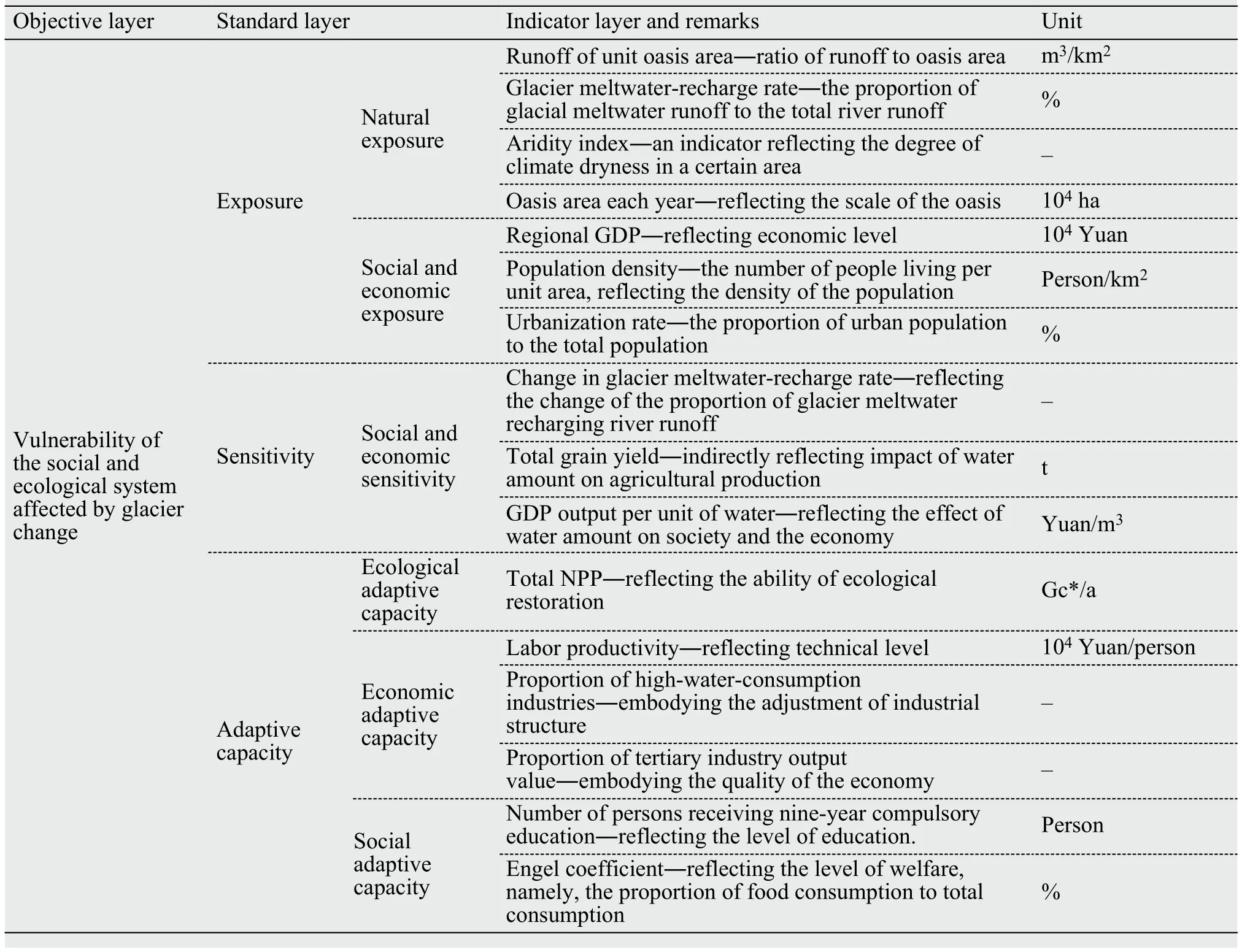
Table 4 The vulnerability-assessment indicator system of the Hexi Inland River Basin, as affected by glacier change in China
3.5 Evaluation method and gradation of vulnerability
Vulnerability-assessment methods are numerous in the community of climate-change research. The merits and shortcoming of some methods have been reviewed (Yang and Zhang, 2010; Yang et al.,2015b). The vulnerability of the oasis system affected by glacier change in the Hexi Inland River Basin is a kind of regional-scale vulnerability with comprehensive characteristics. For that reason, spatial principalcomponent analysis (SPCA), which is a modified PCA approach, is used in the article. The formula for SPCA evaluation is as follows:

where E is an integrated vulnerability-evaluation index, Yiis the ith principal component, and αiis its corresponding contribution. The process of vulnerability evaluation using the SPCA method is seen in the literature of Yang et al. (2015b) and is not restated in this article.
The 16 vulnerability variables standardized are analyzed using the SPAC method. According to the cumulative contribution of principal components, the number of components is affirmed as five; the corresponding results are shown in Table 5. Derived from Table 5 and Formula (3), the vulnerability linear formulae of the oasis social and ecological system affected by glacier change in the Hexi Inland River Basin are created as follows:

where VI is the vulnerability index, and V1–V5are 5 principal components established from 16 initial spatial variables over the period 1995–2010. The higher the VI value, the more vulnerable the oasis social-ecological system is to glacier change.
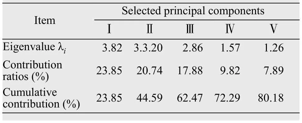
Table 5 Results of spatial principal-component analysis performed in this study
The result computed from the VI model gives a continuous value, and it thus needs to be classified into several levels to deliver various levels of oasis system vulnerability. In this study, we applied Natural Breaks Classification (NBC) to discrete computed values by analyzing the natural properties of the computed values and determining dividing points between clusters (Yang et al., 2015b). In this respect, the vulnerability of the oasis social-ecological system in the Hexi Inland River Basin was graded into five levels:slight, light, medium, heavy, and very heavy (Table 6 and Figure 2).
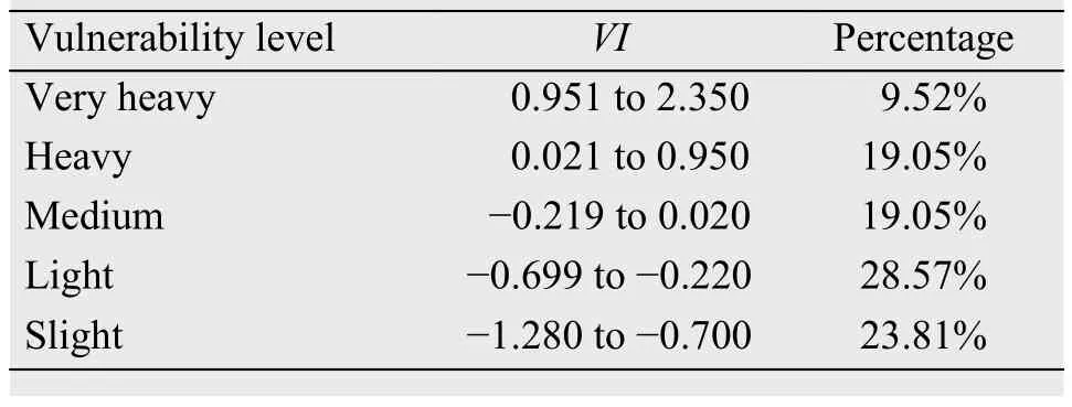
Table 6 Percentage levels of vulnerability of the oasis social-ecological system in the Hexi Inland River Basin
4 Vulnerability of oasis social-ecological system and affecting factors in the Hexi Inland River Basin
4.1 Grade of vulnerability 1995–2010
In the period of 1995–2010, 76.19% of the Hexi Inland River Basin was classified as having light vulnerability or higher (Table 6): 28.57% of areas were in the light-vulnerable zone, 19.05% in the heavy-vulnerable zone and the medium-vulnerable zone, each;and 9.52% in the very-heavy-vulnerable zone. Therefore, the percentage area classified into the heavy- and very-heavy vulnerable zones equals 28.57%; and if the medium vulnerable zone is also included in this calculation, the proportion would be approximately 48.0% of the Hexi Inland River Basin. Therefore these results indicate the oasis social-ecological system was very vulnerable to glacier change in parts of the Hexi Inland River Basin during the years 1995–2010 (Table 6).
4.2 Spatial change of vulnerability
The spatial distribution of the vulnerability of the oasis social-ecological system in the Hexi Inland River Basin was not uniform during 1995–2010(Figure 2); but on the whole, vulnerability had an increasing distribution pattern from the foothills area of the Qilian Mountains to the middle reaches. It is worth noting that urban areas with more socioeconomic development are very vulnerable to glacier change, at very-heavy- and heavy-vulnerable levels.These cities were Wuwei and Jinchang in the Shiyang River Basin; Zhangye, Jiuquan, and Jiayuguan in the Heihe River Basin; and Yumen in the Shule River Basin. The counties with a slight-vulnerability level were mainly distributed in the Heihe and the Shule river basins; and most of them are located in the upstream basin. Overall, cities are more vulnerable than counties in the Hexi Inland River Basin of arid region of northwestern China under the background of rapid glacier change.

Figure 2 Spatial distribution of the vulnerability of the oasis socioecosystem to glacier change in the Hexi Inland River Basin in China
4.3 Key factors affecting vulnerability
The vulnerability of an oasis's social-ecological system results from the combined influence of many factors. However, it is necessary to determine which are the key factors involved and which are the minor factors. To determine answers to these issues, weight analysis is used to test the vulnerability-evaluation indicators; and key factors affecting the oasis-system vulnerability are found and their influence on the oasis-system vulnerability determined.
Results show that during the period of 1995–2010,the key factors influencing the oasis-system vulnerability were the area in oasis, regional GDP, population density, total grain yield, GDP output per unit of water, and proportion of high-water-consumption industries (Table 7). According to the vulnerability-evaluation index system (Table 4), these six indicators belong to the first class index of exposure, sensitivity,and adaptive capacity. Area in the oasis is a natural system-exposure indicator; regional GDP and population density are socioeconomic system-exposure indicators. Total grain yield and GDP output per unit of water are sensitivity indicators, reflecting the degree of sensitivity of the oasis socio-economic system to glacier change. The proportion of high-water-consumption industries is an adaptive capacity indicator.This result shows the vulnerability of the oasis socialecological system in the Hexi Inland River Basin is jointly influenced by exposure, sensitivity, and adaptive capacity. Among the three elements, the contribution of exposure to the oasis system vulnerability is greatest, with the weight reaching 49.32%; sensitivity and adaptive capacity rank second and third, 32.19%and 18.49%, respectively. Overall, the vulnerability of the oasis social-ecological system influenced by glacier change is attributed to high exposure, great sensitivity, and low adaptive capacity in the Hexi Inland River Basin. Further, the expansion in the area of oasis, and the increase in regional GDP and population density have increased the natural scope and socioeconomic volume of the oasis system. As a result,the exposure degree of the oasis social-ecological system to glacier changes is significantly increased,which is the main reason for the high vulnerability of the oasis system. An increase of glacier meltwater induced by warming is not enough to overcome the influence of increased exposure.
5 Adaptation of the oasis social-ecological system to glacier change in the Hexi Inland River Basin
In the inland river watershed of the arid region of Northwestern China, adaptation is the process of adjustment of the oasis social-ecological system to actual or expected glacier change and its effects. Vulnerability is a function of exposure, sensitivity, and adaptive capacity (IPCC, 2001). Exposure is high, sensitivity is great, adaptive capacity is low, and then vulnerability is high; and vice versa. According to their logical relationship, it is necessary to reduce exposure and sensitivity, and heighten adaptive capacity for the oasis system's adaptation to glacier change and its impacts in the arid Hexi Inland River Basin. Based on the analysis results in Section 4.3, in the near-term,the coping countermeasures are to delineate a redline of oasis area to impede continuous oasis expansion,implement efficient water saving, and adjust industrial structure to reduce the proportion of agriculture.
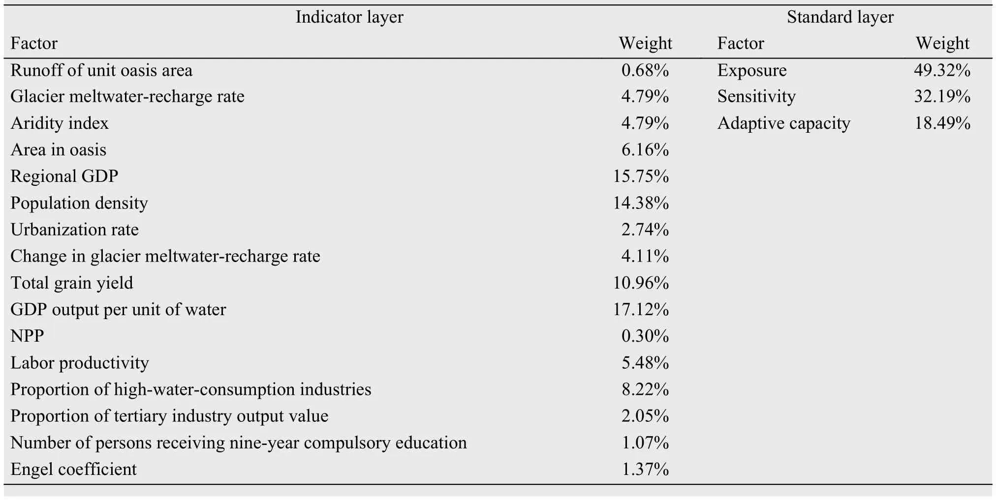
Table 7 Results of weight analysis of vulnerability evaluation indicators
In the inland river watershed of an arid region, adjustment of industrial structure has double functions.On the one hand, it can upgrade industrial structure and boost economic benefit; on the other hand, it may adapt to climate change. At present, however, industrial structure adjustment is mainly adjusting the structure of agricultural planting because the proportion of agriculture exceeds 80% of the area's industry.It can be said that oasis agriculture in the arid region,as a whole, has still at the primary level been dominated by planting over the past 60 years. Therefore, in the medium and long term, transformational adaptation should be implemented and the traditional mode of an agriculture-led oasis economy should be changed. The development of the oasis should be reexamined on the ecological function-value chain; that is, the development and utilization of the glacier service function should be improved in the upper reaches of inland river basins, and the ecological service function should be promoted in the oasis area.
6 Conclusions
The inland river watershed in the arid region is not only affected by climate change, but superimposed on that is glacier change and its effects. The impacts of glacier change on the people and societies in glacierized watersheds has been noted although the studies are very limited. In this article, the Hexi Inland River Basin was chosen as a typical-case area, where the vulnerability of the oasis social-ecological system is assessed by the SPAC method and adaption initiatives in the near, mid, and long terms are put forward.The vulnerability of the oasis system affected by glacier change is not uniform. The oasis economic belt is most vulnerable in the midstream of the Hexi Inland River Basin, accounting for about 30% of the number of the counties and cities studied. Expansion in the area of oasis and the rapid development of society and the economy significantly increased the degree of exposure of the oasis social-ecological system to glacier changes, while the increase of glacier meltwater is not enough to overcome the influence of increased exposure. That is the main reason for high vulnerability of the oasis system. The delineation of a redline of oasis area, the implementation of efficient water saving,and the adjustment of the industrial structure should be done to cope with the glacier-change impacts in the near-term. Transformational adaptation should be implemented and the traditional mode of agriculture-led oasis economy should be fully changed to adapt to a possible water crisis after the glacier runoff crosses the inflection point in the medium and long term.
Acknowledgments:
This work is supported by the Global Change Research Program of China (2013CBA01808) and the China National Natural Science Foundation(41271088). We thank the China Meteorological Data Service Center (CMDC) (http://data.cma.cn/en) and the Western China Environmental and Ecological Science data Center (http://westdc.westgis.ac.cn) for providing partial meteorological observation data and DEM data. We also thank Gao et al. for providing glacier meltwater runoff data.
 Sciences in Cold and Arid Regions2019年1期
- Sciences in Cold and Arid Regions的其它文章
- Increase in medium-size rainfall events will enhance the C-sequestration capacity of biological soil crusts
- How changes of groundwater level affect the desert riparian forest ecosystem in the Ejina Oasis,Northwest China
- Accumulation and geochemical evidence for the Little Ice Age episode in eastern Antarctica
- Primary investigation of statistical correlation between changes in ice volume and area of glaciers
- The analysis of heat and water fluxes in frozen silty soil
- The changing process and trend of ground temperature around tower foundations of Qinghai-Tibet Power Transmission line