新疆包头湖灌区农田土壤水盐热特性空间变异特征
王全九,毕 磊,张继红
新疆包头湖灌区农田土壤水盐热特性空间变异特征
王全九1,2,毕 磊1,张继红1
(1.西安理工大学,西北旱区生态水利工程国家重点实验室培育基地,西安 710048;2.中国科学院水利部水土保持研究所,黄土高原土壤侵蚀与旱地农业国家重点实验室,杨凌 712100)
土壤作为高度变异体,其大尺度下的土壤水盐热分布特征具有空间变异性。为了探究大尺度下的土壤水、盐、热的空间分布特征及空间变异性,以新疆包头湖区域为例,采用经典统计学和地统计学相结合的方法,对土壤水盐热参数的空间分布特征进行分析。结果表明:土壤含水率、导热率及热容量均属于中等偏弱变异程度,土壤含盐量为强变异程度;土壤含水率、含盐量、导热率的半方差函数均可用高斯模型进行拟合,热容量的半方差函数可用指数函数进行拟合;含水率、含盐量、导热率、热容量同一深度各自变量之间均具有较强的空间依赖性,随机因素占总变异程度较低,最大相关距离在2 600~3 900 m。该研究为当地农业灌溉及精细农业的生产提供一定参考。
土壤;水分;盐分;空间变异;热性质
0 引 言
土壤作为不均一变化的连续体,即使在同一个田块中,土壤的物理、化学、生物特性都有很大差异,这是因为受到自然因素(包括成土母质、气候、生物、地形和时间)以及人为因素共同作用,土壤的此特性被称为土壤的空间变异性[1]。随着科学技术的发展,人们逐渐认识到由于土壤空间变异所带来的问题,定量地分析和描述土壤中的各项变异逐渐成为学者们研究的热点[2]。土壤空间变异的复杂性定量化的研究,改进和创新了土壤分类系统,提高田间土壤的研究精度,更好地理解了空间作用与土壤、作物之间的关系,有利于推动精细化农业的发展[3]。而中国新疆地区地处欧亚大陆腹地,远离水汽源地,气候干旱,降雨稀少,水资源时空分布极不均衡,生态环境极度脆弱,新疆地区长期受到土壤盐渍化的影响,严重限制了农业开发和可持续发展[4]。
中国从20世纪80年代开始了对于各种土壤的物理属性变异性研究工作,所涉及的土壤包括黄土、紫色土、喀斯特土、盐碱土、黑土等,分别从水、肥、气、热、金属元素、颗粒组成等方面开展相关研究。土壤的研究尺度从田间尺度发展到流域尺度以及更大尺度。研究土壤空间变异性的方法归纳起来有地统计学、方差分析、自相关分析、谱分析小波分析和分形理论等[5]。目前地统计学是研究空间变异的主要方法,应用半方差函数对土壤空间特性进行描述,在土壤空间变异的研究中应用十分广泛[6-9]。
土壤水热耦合过程广泛存在于农业领域,土壤热性质不仅影响着土壤温度变化,也影响着作物的水分吸收和正常生长。土壤导热率是土壤水、热、溶质耦合数值模型的重要参数。在田间环境中土壤导热率会受到质地、含水率、容重、孔隙分布等因素的影响[10-12]。土壤热特性参数可以直接测定,也可以利用公式计算。而热参数的影响因素众多,国内外学者从不同角度出发建立了很多间接估算土壤导热率的模型[13-21]。由于土壤水分和热特性分布状况可调节水分供给以及改善田间小气候,进而提高作物产量[22]。而对于含盐土壤而言,盐分浓度与土壤热性质也有一定的关系[23]。
但不同地区的土壤性质空间特征不尽相同,并受到取样距离的影响。为了大面积指导农业生产。以新疆包头湖灌区为例,根据实测土壤水分、含盐量以及基本土壤物理参数,对大区域农田土壤导热率进行数值计算,并对土壤水分、含盐量以及导热率的空间分布特征进行分析,为该地区的农业生产提供一定的理论指导。
1 研究方法及数据处理
1.1 研究区概况
试验区域位于新疆巴音郭楞蒙古自治州库尔勒市西南方向35 km处的包头湖灌区。该农场位于孔雀河三角洲的冲积扇下部。地处86°08′~86°26′E,41°45′~41°56′N,东邻库尔勒市永丰渠,西邻孔雀河,北边接壤和什力克乡。该地区属温暖地带,年平均气温10.7 ℃,日照时间长,太阳辐射能量高,热量大,早晚温差大,昼夜气温差为12~17 ℃,特别适合棉花生长,积温平均为4 192.1 ℃,年日照时数为2886.8 h,无霜期为132~181 d,年均降水量为102 mm。主要风向为西北风,光照资源充沛,生长季节长,夏季炎热少雨,冬季严寒少雪。
1.2 采样点布设及样品采集
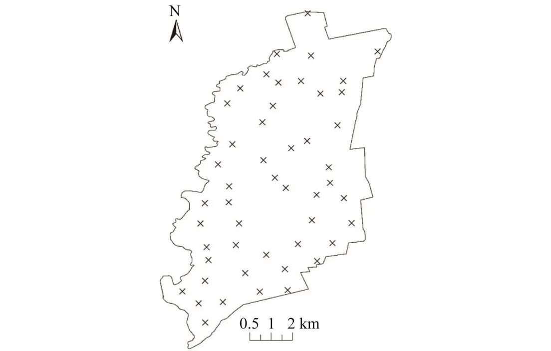
2017年4月春灌后1周取样,根据网格取样法,对包头湖整个农场面积(行政面积71.33 km2,耕地面积34.88 km2)进行划分,由于地形和人为因素(商业街道、居住村落、工厂等)对部分取样点进行了调整,在区域范围内布置50个测点,取样点间距在1.5 km左右,具体取样点分布如图1所示。由于棉田根系活动主要集中在0~60 cm,故各监测点分别监测0~20、20~40、40~60 cm共3个深度土层的土壤,0~20、>20~40、>40~60 cm土壤深度分别命名为1、2、3层度,下文一致。利用土钻法和环刀法进行取样,105 ℃烘箱内烘8~12 h,测定土壤容重及土壤含水率,根据容重换算为土壤体积含水率(土壤体积含水率=土壤质量含水率×土壤干容重)。同时,一部分采集土样风干,过2 mm的筛子后运用英国马尔文Mastersizer仪器有限公司的马尔文激光粒度分析仪2000测定土壤颗粒组成。另一部分风干土样,按照水土比5:1配置土壤溶液,电导率仪测定溶液的电导率(electrical conductivity,EC),拟合公式换算成含盐量。

图1 取样点分布图
1.3 数据分析方法
1.3.1 经典统计学方法
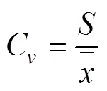
经典统计学以频率为基础、以置信推断为基本特征,通过统计研究变量的最大、最小值、均值、方差、标准差和变异系数来研究变量的变异性。公式如下:

1.3.2 空间变异理论方法
本文采用地统计学的方法对空间分布进行分析。地统计学以区域变化量为基础,以变异函数为核心,以克里格插值为手段研究区域空间变异问题[25-26]。通常以半方差函数表示其空间相关结构。半方差函数公式如下:


文中半方差函数主要采用高斯模型(式(3))和指数模型(式(4))进行拟合。


式中0为块金值;为拱高;为变程,km。
1.3.3 互相关函数
研究2个变量空间分布关系一般采用互相关函数法、交叉变异函数法进行分析[27-28]。本文采用互相关函数法,其公式按下式进行估计,通过MATLAB进行计算。


1.3.4 土壤导热率计算方法


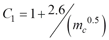
式中1、1、1、1、1为系数表达;ρ土壤的干容重g/cm3;m为表示黏粒含量,%;为体积含水率,%。
在一定容积的土壤中,土壤空气的质量很小,可以忽略不计,所以土壤体积热容量[30]可以表示为


1.4 数据统计
本文应用Excel和SPSS21.软件对土壤相关数据进行处理,应用GS+9.0及ARCGIS对各变量的空间变异特征进行分析并绘制空间分布图,应用Matlab软件对变量互相关性进行计算并绘制图形。
2 结果与分析
2.1 土壤基本理化性统计特征分析
容重与颗粒组成是土壤物理性质中的基本物理性状,同时也是热量方程、水力参数推求中的基本参数。对研究区不同深度的土壤基本物理参数进行统计分析,见表1。整个地区土壤容重较大,各层土壤容重在1.4g/cm3左右,自上而下变化幅度很小。从变异程度C来看,各层土壤容重属于弱变异程度,说明各个层度的土壤质地比较均匀,各层黏粒、粉粒、砂粒均属于中等变异程度。
根据取样分为0~20、>20~40、>40~60 cm共3个土层,每层50个土样,各层不同土壤类型所占比例见表2。按照美国农部制划分标准,该地区每层土壤由砂质壤土和粉砂壤土构成。50个土壤样本中,0~20、>20~40、>40~60 cm土层中34%、30%、22%的土样为砂质壤土,66%、70%、78%为粉砂壤土。
由表2可见,随着土层深度的增加,砂质壤土所占比例逐渐减小,粉砂壤土比例逐渐增加,土壤中粉粒含量增加。将同种土壤类型的颗粒组成进行统计,土壤颗粒组成测定均值见表2,2种土样容重相近,体积含水率粉砂壤土略高于砂质壤土,差距较小为4%。
2.2 土壤水盐热统计特征分析
2.2.1 土壤水盐热参数经典统计
土壤含水率和含盐量统计分析结果见表3。结果表示:0~60 cm土壤体积含水率均值在24.8%~30.3%之间。随着土层深度的增加,根据土壤颗粒组成分析土壤中粉粒含量逐渐增加,保水性能提升,土壤含水率均值也自上而下逐渐增加,且个灌区40~60 cm土层的土壤含水率最小值与最大值之间相差最大,为13.36倍。

表1 土壤物理参数统计表

表2 不同质地土壤样品颗粒含量、容重及含水率统计
由表3可知,土壤盐分含量较大,根据《新疆土壤》确定的盐碱化等级程度划分标准:土壤含盐量<3 g/kg,为非盐化土;3~6 g/kg,为轻度盐化土;6~10 g/kg,为中度盐化土;10~20 g/kg,为重度盐化土;大于20 g/kg,为盐土[31]。根据统计结果,平均含盐量为6.2 g/kg,属于中度盐化土,整个灌区40~60cm层度的土壤含盐量变化幅度最大,为21.33 g/kg。采用地统计学分析的前提是要参数变量服从正态分布,其中土壤含盐量不服从正态分布(渐进显著性值双侧为0.038~0.046,小于显著性水平0.05),其他变量均较符合正态分布,因此对土壤含盐量进行对数处理,结果显示土壤含盐量近似服从对数正态分布。各层土壤含水率C值在0.2左右,属于中等偏弱变异强度,土壤含盐量变异系数在1左右,属于强变异程度。

表3 土壤水盐热统计表
土壤热性质是土壤热状况的内在表现,合理控制土壤热状况,有利于作物生长发育。利用Campbell[29]提出的数学模型,根据土壤基本物理参数对土壤热参数进行计算,计算结果见表3。从地统计学角度来看,根据偏度、峰度以及-检验,各变量接近正态分布。导热率数值整体较低,最低值为0.134 W/(m·K),最大值为0.732 W/(m·K),并且每层最大值与最小值之间差异较大,但从每层的变异系数C来看,在0.1~0.2之间,属于中等偏弱变异程度,说明极大值与极小值点存在较少,变化幅度较为平稳。自上而下来看各层导热率均值在0.5 W/(m·K)左右,但最小值随着土层的增加在不断减小,导热程度不断较低。热容量与土壤干容重和体积含水率相关,土壤热容量随着土壤深度的增加而增加,最大值为3.004 J/(m·K),最小值为1.321 J/(m·K)。根据变异系数C来看,属于中等偏弱变异强度。
2.2.2 土壤水盐热参数空间变异特征
土壤水盐热空间结构性复杂,为了更好地反映该区域的土壤含水率、含盐量、导热率、热容量的空间结构性,以地统计学为基础,对0~60 cm深度的土壤含水率、含盐量以及导热率进行半方差分析,通过选择最优半方差函数模型对其数据进行拟合,半方差函数参数见表4。结果表明:3个土层从上到下含水率、含盐量均可用高斯模型进行较好的拟合。一般用0/(0+)表示空间变异相关性程度,即随机变异占总变异的大小,通常在0~1之间,如在0~25%属于较强的空间依赖性,在25%~75%属于中等强度的空间依赖性,在75%~100%属于较弱的空间依赖性。
空间相关性是由随机因素和土壤自身结构性因素共同作用的结果,其中随机因素(例如施肥量的不同、耕作方式的不同以及人为活动)的影响会使得同一层面的空间相关性减弱。而结构因素包括土壤母质、地形、土壤类型等会使土壤含盐量和含水率的空间相关性增强。各变量的空间相关度在0~25%之间,说明随机因素占总变异很小,自相关引起的空间变异性较强。

表4 土壤水盐热特性半方差函数参数
导热率和热容量半方差函数见表4,结果表明,导热率可用高斯模型进行拟合,热容量由指数模型进行拟合。土壤导热率的决定系数2要高于热容量,均大于0.8,表明可以较好地反映理论模型与实测数据变异函数之间的关系。根据空间相关性来看,各层土壤导热率、热容量具有较强的空间依赖性。
基于半方差函数的分形维数,分形维数越低,样本之间土壤特性值的的差异越大,即均一程度越差,表示变异函数曲率的大小。通过计算由上到下各层的含水率和导热率的分形维数在0.8~2.0之间,存在局部自相关性结构。各层含盐量的整体分形维数较小,分别为1.192、0.914、0.903(除0~20cm含水率分形维数低于含盐量)整体水平小于含水率和导热率,存在突变点,均一程度较差。


表5 最大相关距离统计表
2.3 土壤水盐含量和热特性空间分布特征
土壤含水率、含盐量及热特性空间分布如图2所示。由于采集数据点的有限性,对于未采取的区域进行插值估计,Kringing插值可以对没有采集数据的空间进行分析,给出最优的无偏估计值。在ArcGis10.2中采用Kringing插值法绘制土壤含水率分布图(图2a~图2c),结果显示土壤含水率由西向东在逐渐降低,土壤含水率较低值均在中部地区分布,从中部到东边,又逐渐升高。从斑块大小、颜色均可以反映出土壤含水率空间变异性的变化。图2a土壤含水率斑块化程度高,存在极干或极湿的地点中部较低;由图2b可同样的在中部地区含水率较低,并且含水率较低的斑块分布更广;图2c在较深层的土壤中含水率较低的斑块连接成为更大的区域,其分布主要是沿南北方向。

图2 不同土层土壤含水率、含盐量、导热率和热容量空间分布
各层土壤含盐量如图2d~图2f所示,结果显示图2d中0~20 cm土壤含盐量由北向南盐分呈条状增加,在春灌后,表层土壤中的盐分被淋洗下去,在中下部地区出现“圆形”区域的较高值,在地图上属于未开发地区,土壤返盐严重,表层土壤积盐严重,随着土层的增加,峰值在逐渐消减,最后成为条状。比较图2d、图2e、图2f发现,盐分的累积自北向南逐渐升高,虽然在春灌后将土壤中的盐分淋洗下去,但与灌水量具有一定关系,灌水量较少,盐分淋洗不充分,同时中下部地区远离水源,并且频繁的人为农业活动加快了该地区的盐分累积。极大值虽然在不断减小,但是高含盐量的区域在不断增加。对比含水率和含盐量的分布,中部靠近下侧区域,该地区土壤含水率较低,土壤含盐量偏大,对于农业的增产增收具有一定的影响。
土壤导热率空间分布如图2g~2i所示,0~20 cm土层沿东北-西南方向土壤导热率呈现较低的分布;而在>20~40 cm土层中,土壤导热率分布发生改变,此时南北方向数值较低;而在>40~60 cm土层中,较低值分布带的走向继续像西北方向发生偏移,此时沿西北-东南方向呈现较低分布。对比3土层可发现,土壤导热率较小值逐渐降低,并且分布带的面积自上而下有所增加。
土壤热容量空间分布如图2j~2l所示,结果显示,各层热容量与导热率出现相似分布,沿南北方向出现较低值的分布区域,土壤中盐分较高的地区热容量普遍较低。热容量与含水率相关,土壤含水率较高的区域热容量较大,与含水率分布图具有很强的相似性。
2.4 土壤水盐含量及热特性空间分布互相关性
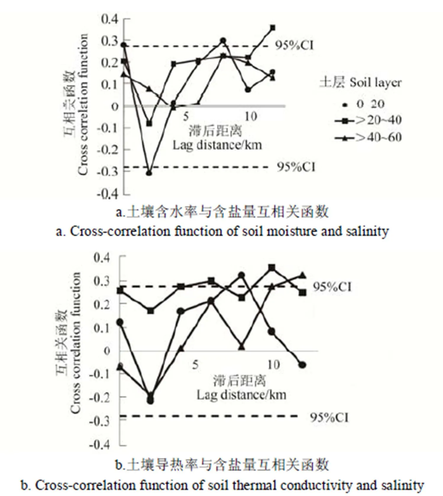
由于土壤中盐分的累积受多种因素作用,为了表达土壤水热与盐分之间的空间分布相关性,分别建立土壤含盐量、含水率以及导热率的空间互相关函数图(图3)。图中虚线为95%置信限,互相关函数超过置信限即为相关达到显著,否则为不显著。

图3 土壤水热与盐分互相关函数图
图3a为土壤含水率与含盐量的互相关函数图,>20~40 cm水分与盐分之间具有相对显著的正相关性,正相关范围在1 km左右;0~20 cm与>40~60 cm水分与盐分未达到显著相关。如图3b所示为土壤导热率与含盐量的互相关函数图,>20~40 cm导热率与盐分之间存在显著的正相关性;0~20 cm与>40~60 cm导热率与盐分未达到显著相关。土壤水热与含盐量空间分布相关性均较低。
3 结 论
对农田大尺度实测土壤水盐以及土壤质地,土壤热特性进行分析,结果显示:
1)土壤含水率、含盐量、容重(含盐量经对数转化)均较符合正态分布;容重属于弱变异程度,含水率属于中等偏弱变异程度,盐分属于强变异程度,经划分属于中度盐化土。
2)各层土壤导热率、热容量较符合正态分布,变异系数属于中等偏弱变异程度,各层导热率均值在0.5 W/(m·K)左右,土壤热容量随着土壤深度的增加而增加,最大值为3.004 J/(m·K),最小值为1.321 J/(m·K)。
3)土壤含水率、含盐量、导热率及热容量在一定范围内具有空间结构特征,半方差函数均可以高斯模型进行拟合(热容量用指数模型进行拟合),均表现出较强的空间依赖性,随机因素占总变异程度较小,同时采样点均小于最大相关距离,符合逻辑。
4)对不同层度的土壤含水率、含盐量以及导热率进行克里格插值,结果表明中部地区土壤含水率较低,并且自上而下土壤含水率较低的斑块逐渐连接形成区域;含盐量自北向南逐渐增高,“圆形”峰值自上而下逐渐降低形成带状分布;土壤导热率较低值的条状分布由开始东北-西南走向像西偏移,较低值的分布区域逐渐增加。热容量与含水率的分布具有相似性,较低值集中在南北方向。20~40 cm水分与盐分具有相对显著的正相关性,正相关范围在1 km左右,同时在在该土层深度导热率与盐分也具有正相关性。
[1] 华孟,王坚. 土壤物理学[M]. 北京农业大学出版社,1993.
[2] 郭丽俊. 农田土壤水盐特性的空间变异性研究[D]. 杨凌:西北农林科技大学,2011.
Guo Lijun. Study on Spatial Variability of the Field Soil Hydraulic and Saline Properties[D]. Yangling: Northwest A & F University, 2011. (in Chinese with English abstract)
[3] 杨玉玲,文启凯,田长彦,等. 土壤空间变异研究现状及展望[J]. 干旱区研究,2001,18(2):50-55.
Yang Yuling, Wen Qikai, Tian Changyan, et al. The status quo and prospect of spatial variability of soil [J]. Arid Zone Res,2001,18(2):50-55. (in Chinese with English abstract)
[4] 胡明芳,田长彦,赵振勇,等. 新疆盐碱地成因及改良措施研究进展[J]. 西北农林科技大学学报:自然科学版,2012,40(10):111-117.
Hu Mingfang, Tian Changyan, Zhao Zhenyong, et al. Salinization causes and research process of technologies improving saline-alkali soil in Xinjiang[J]. Journal of Northwest A & F University, 2012, 40(10):111-117. (in Chinese with English abstract)
[5] 杨卫中,王一鸣,李保国. 土壤含水量空间变异性的频域分析方法[J]. 水利学报,2011,42(5):580-587.
Yang Weizhong, Wang Yiming, Li Baoguo. Frequency-domain analysis of spatial variability of soil properties[J]. Journal of Hydraulic Engineering, 2011, 42(5):580-587. (in Chinese with English abstract)
[6] 栗现文,靳孟贵. 不同水质膜下滴灌棉田盐分空间变异特征[J]. 农业机械学报,2014,45(11):180-187.Li Xianwen, Jin Menggui. Spatial variability of cotton field salinity under mulched drip irrigation with brackish and fresh water[J].Transactions of the Chinese Society for Agricultural Machinery, 2014, 45(11): 180-187. (in Chinese with English abstract)
[7] 姚荣江,杨劲松,刘广明,等. 黄河三角洲地区典型地块土壤盐分空间变异特征研究[J]. 农业工程学报,2006,22(6):61-66.Yao Rongjiang, Yang Jinsong, Liu Guangming, et al, Spatial variability of soil salinity in characteristic field of the Yellow River Delta[J].Transactions of the Chinese Society of Agricultural Engineering (Transactions of the CSAE), 2006, 22(6): 61-66.(in Chinese with English abstract)
[8] 徐英,陈亚新,史海滨,等. 土壤水盐空间变异尺度效应的研究[J]. 农业工程学报,2004,20(2):1-5.Xu Ying, Chen Yaxin, Shi Haibin, et al. Scale effect of spatial variability of soil water-salt[J].Transactions of the Chinese Society of Agricultural Engineering (Transactions of the CSAE), 2004, 20(2): 1-5.(in Chinese with English abstract)
[9] 王卫华,王全九,武向博,等. 黑河中游绿洲麦田土壤水气热参数田间尺度空间分布特征[J]. 农业工程学报,2013,29(9):94-102.Wang Weihua, Wang Quanjiu, Wu Xiangbo, et al. Characteristics of spatial distribution of soil water-air-heat parameters in typical oasis croplands at middle reaches of Heihe River[J].Transactions of the Chinese Society of Agricultural Engineering (Transactions of the CSAE), 2013, 29(9): 94-102. (in Chinese with English abstract)
[10] 王卫华,王全九,王铄. 土石混合介质导气率变化特征试验[J]. 农业工程学报,2012,28(4):82-88.Wang Weihua, Wang Quanjiu, Wang Shuo. Experimental research on change characteristics of soil air permeability in stony soil medium[J].Transactions of the Chinese Society of Agricultural Engineering (Transactions of the CSAE), 2012, 28(4): 82-88. (in Chinese with English abstract)
[11] 苏李君,王全九,王铄,等. 基于土壤物理基本参数的土壤导热率模型[J]. 农业工程学报,2016,32(2):127-133.Su Lijun, Wang Quanjiu, Wang Shuo, et al. Soil thermal conductivity model based on soil physical basic parameters[J].Transactions of the Chinese Society of Agricultural Engineering (Transactions of the CSAE), 2016, 32(2): 127-133. (in Chinese with English abstract)
[12] Zhao P, Shao M, Wang T. Spatial distributions of soil surface-layer saturated hydraulic conductivity and controlling factors on dam farmlands[J]. Water Resources Management, 2010, 24(10): 2247-2266.
[13] Chung S O, Horton R. Soil heat and water flow with a partial surface mulch[J]. Water Resources Research, 1987, 23(12): 2175-2186.
[14] Campbell G S. Soil Physics with Basic. 1986[J]. Soil Science, 1986, 142(6):367-368.
[15] de Vries D A. Thermal properties of soils[M]//van Wjik W R. Physics of Plant Environment. Amsterdam: North-Holland Publishing Company, 1963: 210-235.
[16] Johansen O. Thermal Conductivity of soils[J]. Thermal Conductivity of Soils, 1977,10(5):637-643.
[17] Côté J, Konrad J M. A generalized thermal conductivity model for soils and construction . [J]. Canadian Geotechnical Journal, 2005, 42(42): 443-458.
[18] Lu Sen, Ren Tusheng, Gong Yuanshi, et al. An improved model for predicting soil thermal conductivity from water content at room temperature[J]. Soil Science Society of America Journal, 2007, 71(1):8-14.
[19] 李婷,王全九,樊军. 土壤热参数确定方法比较与修正[J]. 农业工程学报,2008,24(3):59-64.Li Ting, Wang Quanjiu, Fan Jun. Modification and comparison of methods for determining soil thermal parameters[J].Transactions of the Chinese Society of Agricultural Engineering (Transactions of the CSAE), 2008, 24(3):59-64.(in Chinese with English abstract)
[20] 王铄,王全九,樊军,等土壤导热率测定及其计算模型的对比分析[J]. 农业工程学报,2012,28(5):78-84.Wang Shuo, Wang Quanjiu, Fan Jun et al. Soil thermal properties determination and prediction model comparison[J].Transactions of the Chinese Society of Agricultural Engineering (Transactions of the CSAE), 2012, 28(5): 78-84.(in Chinese with English abstract)
[21] 王卫华,李建波,王铄,等. 土壤热特性参数空间变异性与拟合方法研究[J]. 农业机械学报,2015,46(4):120-125.Wang Weihua, Li Jianbo, Wang Shuo, et al. Spatial variability of soil thermal parameters and its fitting method[J].Transactions of the Chinese Society for Agricultural Machinery, 2015, 46(4): 120-125.(in Chinese with English abstract)
[22] 李建波,王卫华,Su Yiming,等. 温室土壤含水率与导热率空间分布及相关性[J]. 农业工程学报,2016,32(19):127-132.Li Jianbo, Wang Weihua, Su Yiming, et al. Spatial pattern and interrelation of soil water content and thermal conductivity in greenhouse[J].Transactions of the Chinese Society of Agricultural Engineering (Transactions of the CSAE), 2016, 32(19): 127-132.(in Chinese with English abstract)
[23] 李毅,邵明安,王文焰,等. 质地对土壤热性质的影响研究[J]. 农业工程学报,2003,19(4):62-65.Li Yi,Shao Ming’an,Wang Wenyan,et al. Influence of soil textures on the thermal properties[J].Transactions of the Chinese Society of Agricultural Engineering (Transactions of the CSAE), 2003, 19(4): 62-65.(in Chinese with English abstract)
[24] Warrick A W, Nielsen D R. Spatial variability of soil physical properties in the field[M]//Hillel D. Applications of Soil Physics. NewYork: Academic Press, 1980: 319-344.
[25] Sylla M, Stein A, Breemen N V, et al. Spatial variability of soil salinity at different scales in the mangrove rice agro-ecosystem in West Africa[J]. Agriculture Ecosystems & Environment, 1995, 54(1/2): 1-15.
[26] 周慧珍,龚子同. 土壤空间变异性研究[J]. 土壤学报,1996,33 (3):232-241.Zhou Huizhen, Gong Zitong. Study on soil spatial variability[J]. Acta Pedologica Sinica,1996,33(3):232-241. (in Chinese with English abstract)
[27] 徐英,周明耀,薛亚锋. 水稻叶面积指数和产量的空间变异性及关系研究[J]. 农业工程学报,2006,22(5):10-14.Xu Ying, Zhou Mingyao, Xue Yafeng. Spatial variability and relationships of rice leaf area index and yield[J].Transactions of the Chinese Society of Agricultural Engineering (Transactions of the CSAE), 2006, 22(5): 10-14. (in Chinese with English abstract)
[28] Davidoff, Selim H M. Correlation between spatially variable soil misture content and soil temperature[J]. Soil Science,1988, 145(1): 1-10.
[29] Campbell G S. Soil physics with BASIC. Transport models for soil-plant systems.[J]. Journal of Hydrology, 1987, 90(3): 359-360.
[30] 秦耀东. 土壤物理学[M]. 北京高等教育出版社, 2003.
[31] 罗毅. 干旱区绿洲滴灌对土壤盐碱化的长期影响[J]. 中国科学:地球科学,2014(8):1679-1688.
Luo Yi. The long term impacts of drip irrigation on soil salinity in agricultural land of oasis in arid region of northwest China[J]. Scientia Sinca Terrae, 2014, 44(8): 1679-1688. (in Chinese with English abstract)
Spatial variability analysis of large-scale soil water, salt and heat characteristics in Baotou lake irrigation area of Xinjiang
Wang Quanjiu1,2, Bi Lei1, Zhang Jihong1
(1.,,710048,; 2.,,712100,)
As a highly heterogeneous soil, its spatial variability has seriously affected the formulation of precise management measures for water and salt in farmland and the efficient use of farmland water and soil resources. The purpose of this paper was to study the spatial distribution characteristics and spatial variability of soil water, salinity and heat in large scale region. Taking the Baotou Lake region of Xinjiang as an example, the soil samples were taken about 1 week after the spring irrigation, and soil moisture, salinity, bulk density, and particle composition were measured. The spatial distribution characteristics of water, salt, thermal parameters were analyzed by using a combination of classical statistics and geostatistics and GS+ software and ARCGIS software were used to process the data. The soil moisture, salinity, and soil texture were analyzed. The soil thermal conductivity and soil heat capacity were calculated. The spatial distribution feature maps were plotted. The results showed that soil moisture and salinity gradually increased with the increase of soil depth. According to the classification standard of Xinjiang Soils, the soil in the studied area belonged to the moderate salinized soil. The overall thermal conductivity of the soils were low, with a minimum value of 0.134 W/(m·K) and a maximum value of 0.732 W/(m·K). The soil thermal conductivity averaged around 0.5 W/(m·K). The soil heat capacity increased with the increase of soil depth. The maximum value was 3.004 J/(m·K) and the minimum value was 1.321 J/(m·K). The soil bulk density had a weak variability; soil moisture content, thermal conductivity and heat capacity all had moderately weak variability; soil salinity had a strong variability. The semivariogram functions of soil moisture, soil salinity and soil thermal conductivity could be fitted by Gaussian models. The semivariance function of soil heat capacity could be fitted by an exponential model. There was a strong spatial dependence between the soil moisture at the same depth. The random factors accounted for low degree of total variation. The maximum correlation distance was 2 600 m-3 900 m. The sampling distance was about 1 500 m, which was reasonable. The spatial distribution maps of salt salinity interpolated by Kriging interpolation showed that the soil moisture was low in the middle area of the study area and increased from the east to the west. The Kriging interpolation showed that the soil salinity had an increasing trend from north to south. With the increase of soil depth, the peak area of the “circular” peak area gradually decreased and the shape formed a strip distribution area. And the lower values of the thermal conductivity of the surface soil were mainly distributed in the northeast-southwest direction, and the distribution belt with lower values gradually shifted westward as the soil depth increased. At the soil depth of 20-40 cm, there was a relatively significant positive correlation between soil moisture and salinity, and the range of positive correlation was about 1 km. This research results could provide valuable information for local agricultural irrigation and precision agriculture production.
soils; moisture; salinity; spatial heterogeneity; heat characteristics
10.11975/j.issn.1002-6819.2018.18.017
S152.8
A
1002-6819(2018)-18-0138-08
2018-06-21
2018-08-10
国家重点研发计划项目(2016YFC0501401-02);新疆维吾尔自治区重大科技专项项目(2016A03008);国家自然科学基金(5167090151)
王全九,内蒙古人,博士,博士生导师,主要从事农业水土资源与生态环境研究。Email:wquanjiu@163.com
王全九,毕 磊,张继红. 新疆包头湖灌区农田土壤水盐热特性空间变异特征[J]. 农业工程学报,2018,34(18):138-145. doi:10.11975/j.issn.1002-6819.2018.18.017 http://www.tcsae.org
Wang Quanjiu, Bi Lei, Zhang Jihong. Spatial variability analysis of large-scale soil water, salt and heat characteristics in Baotou lake irrigation area of Xinjiang[J]. Transactions of the Chinese Society of Agricultural Engineering (Transactions of the CSAE), 2018, 34(18): 138-145. (in Chinese with English abstract) doi: 10.11975/j.issn.1002-6819.2018.18.017 http://www.tcsae.org

