Deeply concealed half-graben at the SW margin of the East European Craton(SE Poland)—Evidence for Neoproterozoic rifting prior to the break-up of Rodinia
P.Krzywie,P.Poprw,M.Mikołjzk,S.Mzur,M.Mlinowski
aInstitute of Geological Sciences,Polish Academy of Sciences,Warsaw,Poland
bAGH University of Sciences and Technology,Cracow,Poland
cInstitute of Geophysics,Polish Academy of Sciences,Warsaw,Poland
Abstract Baltica was one of continents formed as a result of Rodinia break-up 850—550 Ma.It was separated from Amazonia(?)by the Tornquist Ocean,the opening of which was preceded by Neoproterozoic extension in a network of continental rifts.Some of these rifts were subsequently aborted whereas the Tornquist Rift gave rise to splitting of Rodinia and formation of the Tornquist Ocean.The results of 1-D subsidence analysis at the fossil passive margin of Baltica provided insight in the timing and kinematics of continental rifting that led to break-up of Rodinia.Rifting was associated with Neoproterozoic syn-rift subsidence accompanied by deposition of continental coarse-grained sediments and emplacement of continental basalts.Transition from a syn-rift to post-rift phase in the latest Ediacaran to earliest early Cambrian was concomitant with deposition of continental conglomerates and arkoses,laterally passing into mudstones.An extensional scenario of the break-up of Rodinia along the Tornquist Rift is based on the character of tectonic subsidence curves,evolution of syn-rift and post-rift depocenters in time,as well as geochemistry and geochronology of the syn-rift volcanics.It is additionally reinforced by the high-quality deep seismic reflection data from SE Poland,located above the SW edge of the East European Craton.The seismic data allowed for identification of a deeply buried(11—18 km),well-preserved extensional half-graben,developed in the Palaeoproterozoic crystalline basement and filled with a Neoproterozoic syn-rift volcano-sedimentary succession.The results of depth-to-basement study based on integration of seismic and gravity data show the distribution of local NE—SW elongated Neoproterozoic depocenters within the SW slope of the East European Craton.Furthermore,they document the rapid south-eastwards thickness increase of the Neoproterozoic succession towards the NW—SE oriented craton margin.This provides evidence for extensive crustal thinning occurring prior to the break-up of Rodinia and formation of the Tornquist Ocean.
Keywords Rodinia,Baltica,Tornquist rift,Orsha-Volyn Aulacogen,Tornquist Ocean,Neoproterozoic,Seismic data,Gravity data
1. Introduction
Neoproterozoic volcano-sedimentary syn-rift successions have been extensively studied in many parts of the world,due to their hydrocarbon potential(e.g.,Craig et al.,2010,2013)or association with important ore deposits(e.g.,Emetz et al.,2004;Gibson et al.,2016,2017).Often,owing to a complex geological evolution during consecutive Paleozoic,Mesozoic or Cenozoic tectonic events,original Neoproterozoic riftrelated structures might have been partly or completely obliterated by younger tectonic features.Neoproterozoic rift structures,because of continued subsidence,might have been also buried to a great depth and could be presently concealed under several kilometers thick successions of younger rocks.All this makes seismic reflection imaging of such structures very challenging, with a relatively few examples of fully or at least partly preserved Neoproterozoic extensional structures that havebeen imaged onseismic data(e.g.,Craig et al.,2010;Jinhu and Wenqing,2016,2016;Gibson et al.,2016,2017;Lassen et al.,2001).
Neoproterozoic(850—550 Ma)breakup of super continent Rodinia gave rise to formation of several continental plates including Baltica and Amazonia,separated by the Tornquist Ocean(Bogdanova et al.,2008;Nikishin et al.,1996).Neoproterozoic rifting in present-day SE Poland and W Ukraine led to the formation of two major rift zones:the Tornquist Rift—a precursor of the Tornquist Ocean,and the Orsha-Volyn Aulacogen that became dormant towards the middle of the Neoproterozoic and eventually became aborted(Fig.1;Bogdanova et al.,2008).Previous models of formation of the Neoproterozoic volcano-sedimentary basin fill in SE Poland,based on well data,indicated a classic syn-to post-rift scenario consistent with a triple junction model postulated for the Tornquist and Orsha-Volyn Rifts(Nawrocki and Poprawa,2006;Poprawa and Paczeésna,2002;Poprawa,2006a).
The SW slope of the East European Craton(EEC),covered by a thick pile of Ediacaran and Phanerozoic sediments,was extensively studied using deep refraction data that provided information regarding the top of basement configuration and deep crustal architecture(Guterch and Grad,2006;Guterch et al.,2010;Janik et al.,2009).Recently,the regional POLCRUST-01 deep seismic profile(Malinowski et al.,2015)and the PolandSPAN™survey(e.g.,Krzywiec et al.,2017a,2017b)provided additional information on the structure of the sedimentary cover overlying the EEC in SE Poland.In this paper,we present new evidence based on the PolandSPAN™seismic profile and gravity data that documents the presence of two superimposed structural trends associated with Neoproterozoic rifting in accordance with the model proposed by Poprawa and Paczeésna(2002).
2. Geological setting
The SW margin of the EEC is defined by the Teisseyre-Tornquist Zone(TTZ)that corresponds to a transition between the thick crust of the EEC and the thinner crust underlying the West European Paleozoic Platform(e.g.,Grad et al.,2002;Guterch et al.,2010).In SE Poland,it is covered by a thick pile of Neoproterozoic,Paleozoic,Mesozoic and Cenozoic sediments.As evidenced by deep refraction data,the TTZ in SE Poland is related to a south-westward shallowing of Moho,from 42 to 50 km in the east,beneath the EEC,to 31—38 km in the west,below the West European Paleozoic Platform(Guterch and Grad,2006;Guterch et al.,2010).This zone of Moho rise coincides with a descent of the top of crystalline basement plunging to the depth of 20—22 km(Malinowski et al.,2015).
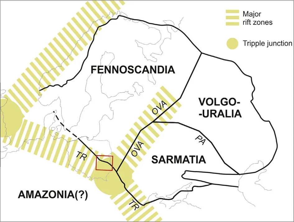
Fig.1 Rodinia breakup—a model(based on Poprawa,2006a).Structure of Baltica after Bogdanova et al.(2008).TR:Tornquist Rift;OVA:Orsha-Volyn Aulacogen;PA:Pachelma Aulacogen.Red rectangle in SE Poland and W Ukraine represents area shown on maps in Figs.5 and 6.
A next major stage of tectonic evolution was related to the formation of a Caledonian foredeep basin.Subsidence curves constructed for numerous wells located in SE Poland suggest that a Silurian—lowermost Devonian succession was formed in a flexural basin located above the EEC (Poprawa,2006b).Importantly,the study area was buried under the Caledonian foredeep sedimentary fill but was not influenced by any compressional deformations i.e.,was not incorporated into the frontal part of the Caledonian orogenic belt.
In the latest Devonian,the so-called Bretonian tectonic phase led to significant(up to 2—3 km of vertical displacement)uplift of several basement blocks along steep,SW—NE oriented,mostly reverse faults(Krzywiec,2009;Krzywiec et al.,2017a).This faulting was,however,rather localized and did not affect the entire area analyzed in this paper.
Following deposition of a shallow marine-deltaic Carboniferous succession,late Carboniferous Variscan compression significantly deformed the entire sedimentary cover and resulted in the formation of the easternmost segment of the Variscan fold-and-thrust belt(see Krzywiec et al.,2017a,2017b for detailed analysis and further references).The Neoproterozoic succession was partly involved in Variscan thrusting but in the area analyzed in this paper a basal detachment of the Variscan thin-skinned frontal thrust belt was located at the base of the Silurian shales,hence the Neoproterozoic—Ordovician succession was not deformed.
Post-Variscan(latest Carboniferous)uplift in SE Poland led to extensive erosion and the formation of a regionalun conformity,above which the Permo-Mesozoic succession of the Polish Basin was deposited.The Polish Basin was inverted in the Late Cretaceous but the area discussed in this paper was not subjected to any significant inversion-related tectonic movements(Krzywiec et al.,2009).
3. Data
The PolandSPAN®regional high-end seismic survey was acquired above the SW edge of the East European Craton with long recording time(12 s),high nominal fold(480),long offsets(12 km),tight receiver/shot spacing(25 m)and broadband sweep(2—150 Hz).Data processing included Pre-Stack Time Migration(PreSTM)and Pre-Stack Depth Migration(PSDM).PolandSPAN®profiles precisely imaged topmost part of the crystalline basement and the Neoproterozoic—Mesozoic/Cenozoic sedimentary cover(cf.Krzywiec et al.,2017a).In SE Poland,a rich well database consisting of deep research wells drilled by the Polish Geological Institute and exploratory wells drilled by the oil industry was used for calibration of seismic data.Due to a generally very high quality of seismic imaging it was possible to extrapolate stratigraphic interpretation calibrated by wells in shallower parts of the basin into its deeper parts,and reliably interpret seismic horizons down to 10—15 km or even deeper.
3D gravity inverse modeling was used to provide information about the depth and geometry of crystalline basement as well as the thickness of Ediacaran sediments.The gravity data were provided in a digital format by the National Geological Archive of the Polish Geological Institute.The data were derived from gravity ground stations and gridded at a 2000 m interval.The Bouguer correction reduction density applied was 2.67 g/cc.The theoretical basis and details of the inversion procedure are described in Barnes and Barraud(2012).A Moho surface grid based on refraction seismic data was used in this exercise(Majdaénski,2012).The density contrast across the Moho was assumed at 0.35 g/cc.The gravity was inverted for a top crystalline basement surface assuming a lowdensity contrast across the top of basement(0.2 g/cc)and a lack of lateral density variation in the basement and sediments.The inversion process was constrained by well tops and 2D top basement horizons extracted from the seismic data available(Mikołajczak,2016).The top of Neoproterozoic(Ediacaran)horizon,used in the thickness calculation,was produced by gridding of seismic and well data.
4. Neoproterozoic tectonosedimentary evolution—A synthesis
Neoproterozoic rifting in SE Poland and W Ukraine is suggested by a characteristic pattern of tectonic subsidence,indicative of syn-rift subsidence,followed by post-rift thermal sag during the latest Ediacaran,Cambrian and Ordovician(Paczeésna,2006,2010,2014;Poprawa and Paczeésna,2002;Poprawa,2006a).This is coherent with facies development of the Ediacaran to Cambrian clastic basin- fill(Paczeésna,2006,2014).This concept is also confirmed by the extensive presence of Ediacaran rift-related magmatic rocks,mainly basalts(Fig.2;Bakun-Czubarow et al.,2002;Białowolska et al.,2002;Emetz et al.,2004;Krzemiénska,2005).
The lowermost part of the sedimentary cover overlying the crystalline basement is the clastic,sandstone-dominated Polesie Formation with a thickness up to 1000 m(Fig.2;Makhnatsch et al.,1976).The age of the Polesie Formation and relevant phase of extension has imprecise time constrains from the Early to Late Neoproterozoic(Poprawa and Paczeésna,2002;Poprawa,2006a).
When the King heard the news that his daughter had actually laughed, he was more than delighted, and had Peter and his marvellous train brought before him
Above the Polesie Formation,after a long period of intense erosion,coarse-grained clastic deposits were locally deposited(Fig.2;Paczeésna,2010;Poprawa and Paczeésna,2002).Then,extensive flood basalts were formed(Fig.2)that constitute a large province encompassing western Ukraine,eastern Poland,and southwestern Belarus.A maximum thickness(up to 400—600 m)of this basaltic formation(known as the Sławatycze Formation in Poland;cf.Paczeésna,2010)coincides with the axial part of the Orsha-Volyn Aulacogen(cf.Shumlyanskyy,2016).Geochemical characteristics of magmas indicate their emplacement in a rift-related setting(Bakun-Czubarow et al.,2002;Białowolska et al.,2002;Emetz et al.,2004;Krzemiénska,2005).The age of this major rift event is constrained by radiometric dating of basaltic lavas and associated tuffs to the latest Neoproterozoic(Ediacaran)(Fig.2;Compston et al.,1995;Elming et al.,2007;Shumlyanskyy and Andréeasson,2004;Shumlyanskyy et al.,2007).
Following this wide-spread magmatic activity,the study area became part of a large Ediacaran—Early Paleozoic basin system developed along the SW margin of Baltica.Since the latest Ediacaran throughout the Cambrian and Ordovician a gradual decrease of subsidence is observed,indicating a thermal sag stage of the basin(Fig.3;Poprawa and Paczeésna,2002;Poprawa,2006a).Such a subsidence pattern suggests the presence of significant Ediacaran extension prior to deposition of a post-rift succession.This Ediacaran rifting phase was initiated with deposition of continental coarse-grained sediments(Fig.2;cf.Paczeésna,2010).Subsequently,this syn-rift basin was filled with continental conglomerates and arkoses, laterally replaced by mudstones,with facies variations possibly controlled by active extensional faults(Paczeésna,2006,2014).The coarse-grained syn-rift succession passes up-section into shallow marine claystones and mudstones.
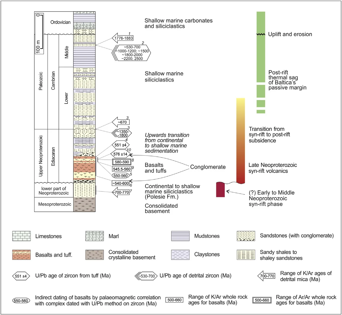
Fig.2 Synthetic lithostratigraphic profile of Neoproterozoic—Lower Paleozoic section in SE Poland(after Poprawa,2006a).
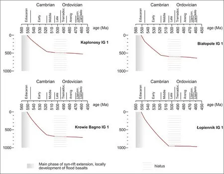
Fig.3 Tectonic subsidence curves from selected wells from SE Poland documenting Neoproterozoic rifting followed by thermal sag phase(based on Poprawa and Paczeésna,2002;Poprawa,2006a).Location of those 4 wells is shown in Figs.5 and 6.
A characteristic latest Ediacaran to Ordovician synrift to post-rift subsidence pattern(Fig.3)is observed along the entire SW margin of Baltica,from Scandinavia to the Black Sea(e.g.,Poprawa,2006a;Poprawa et al.,1999).It is very coherent,and suggests that this zone evolved into a passive continental margin(e.g.,Poprawa,2006a;Poprawa et al.,1999)due to the breakup of the Rodinia supercontinent(Bogdanova et al.,2008;Nikishin et al.,1996;Poprawa et al.,1999).
5. Geophysical evidence of Neoproterozoic extension
High-quality deep seismic imaging of the Poland-SPAN®data allowed for precise interpretation of the top of Precambrian crystalline basement,top of Ediacaran,top of Cambrian and top of Ordovician even atagreatdepth of9—18km (Fig.4).Stratigraphic calibration was based on numerous wells drilled in the shallower part of the basin.Correlation of all the key seismic horizons should be regarded as very reliable.
An extensional half-graben visible on a seismic profile and developed in the Palaeoproterozoic crystalline basement might be filled up by a Neoproterozoic syn-rift volcano-sedimentary succession.Volcanic layers could be in this case related to higheramplitude reflectors locally visible within the graben in fill.Crustal scale normal faults might have acted as the pathways for the Ediacaran up-section lava migration that have given rise to the formation of the extensive flood basalts mentioned above(Białowolska et al.,2002;Compston et al.,1995;Elming et al.,2007;Emetzet al.,2004;Krzemiénska,2005;Shumlyanskyy et al.,2007).
It is worth noting that NW of the analyzed area,in the SW part of the Baltic Sea,seismic reflection data documented a very similar Neoproterozoic half-graben of similar size(Lassen et al.,2001).Similarly to SE Poland,thin-skinned thrusting(Caledonian in the Baltic Sea,Variscan in Poland)overridden this Neoproterozoic extensional zone but it did not cause any inversion/reactivation,so the graben was preserved intact until present.
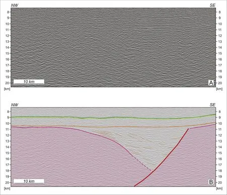
Fig.4 Part of regional seismic profile(PSDM)showing deeply buried half-graben filled by Neoproterozoic syn-rift succession.A—Uninterpreted;B—Interpreted.Violet:top crystalline basement,orange:top Neoproterozoic,dotted orange:intra-Neoproterozoic horizons depicting sedimentary in fill of the half-graben,light green:top Cambrian,top dark green:top Ordovician.Vertical exaggeration 2×.
Even older,Mesoproterozoic—Neoproterozoic rifts have been imaged on seismic data in the northeasternmost part of the EEC (Bogdanova et al.,2008).The Neoproterozoic half-graben identified on seismic data in SE Poland also closely resembles similar features of the same age recognized in the Tarim Basin in SW China(Jinhu and Wenqing,2016).
Depth-to-basement configuration in SE Poland shows a relatively smooth top of the EEC crystalline basement rapidly sloping toward the SW beneath the adjacent West European Paleozoic Platform(Fig.5).The depth to basement increases from the NE to SW by~16 km,from ~2 km to 18 km(Fig.5).The basement slope is associated with a perturbation of Moho that defines the position of the TTZ.Consequently,the depth-to-basement geometry provides evidence for a crustal neck coincident with the TTZ,where a step in the Moho depth is associated with a steep basement slope.
Besides the SW-ward slope of the top basement,a feature characteristic of the entire TTZ,another trend is noticeable in SE Poland that is expressed by basement deepening towards the SE(Fig.5).Especially,the NE corner of the basement low in Fig.5 has a shape of an elongated graben extending in a NNE-SSW direction(Fig.5).This feature revealed by the depth-to basement map coincides with the Neoproterozoic graben imaged in a seismic profile(Fig.4).Consequently,the map in Fig.5 documents a regional extent of syn-rift structure running in a NNE—SSW direction even though the graben in question terminates against a top basement scarp that is associated with the TTZ(Fig.5).The lesser depth of the graben on the depthto-basement map(Fig.5;13.5 km)in comparison to the seismic profile(Fig.4;18 km)might be a consequence of limited lateral resolution of inverse gravity modeling.The narrow,deepest part of the graben was probably smoothed out by the inversion algorithm.An alternative though less likely explanation is the high density of Neoproterozoic sediments in the deepest part of the graben that might be comparable to the density of basement rocks.An overall deep seismic imaging of the PolandSPAN®data is of exceptional quality,it should be,however,stressed that at the greatest depths,above 14—15 km,the continuity of particular seismic horizons is less certain so the exact position of the top of crystalline basement has an inherited depth error,that might also,at least partly,explain the discrepancy between the interpreted seismic data and depth-to-basement derived using gravity data.Detailed 2D gravity—magnetic modeling might shed additional light onto this problem in the future.
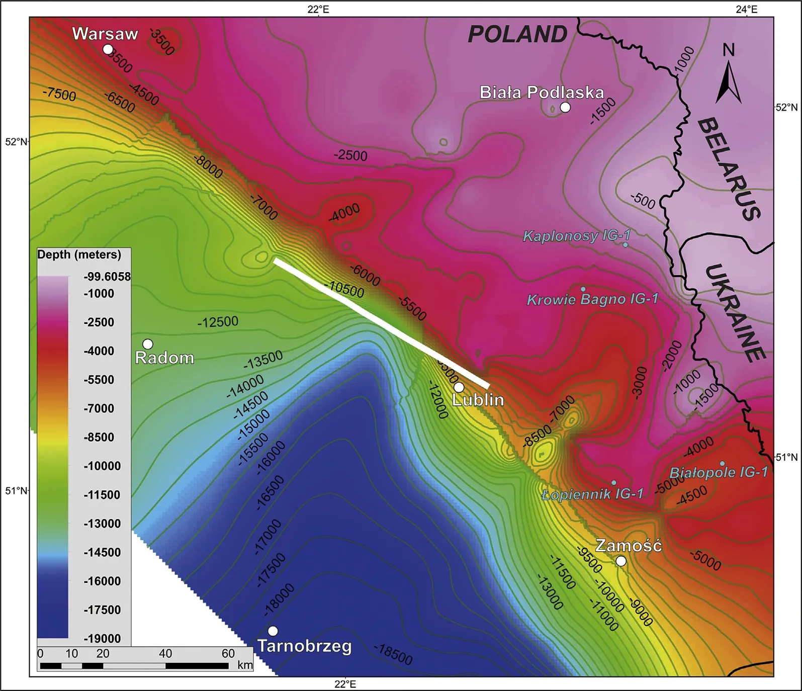
Fig.5 Depth-to-basement map for the SW margin of the East European Craton in SE Poland(cf.Fig.1).Depth to crystalline basement is derived from 3D gravity inversion constrained by seismic and well data.Partly based on Mikołajczak(2016).White line — location of the seismic profile shown in Fig.4;blue dots—location of wells from Fig.3.The coordinate system,Poland,1992,is based on the ETRS89 datum,GRS80 spheroid and the Transverse Mercator projection with 19°E as a central meridian.
The isopach map from Fig.6 shows that vast part of the sedimentary pile between the top of basement and surface is represented by a Neoproterozoic succession.This is not surprising taking into account the scale of rifting preceding the break-up of Rodinia in the latest Neoproterozoic.However,it is not excluded that the present-day Neoproterozoic thickness,visualized on the map(Fig.6),was amplified by subsequent tectonic deformation.The Neoproterozoic isopachs clearly delineate the NNE—SSW oriented graben that is coincident with the feature imaged in the seismic profile described above (Fig.4).Therefore,the isopach map(Fig.6)provides an additional argument in favor of roughly simultaneous rifting in NE—SW and NW—SE directions,the latter ultimately leading to the opening of the Tornquist Ocean.
6. Conclusions
Interpretation of the high-quality deep seismic reflection data of the PolandSPAN®project provided an unequivocal proof that the Precambrian (Paleoproterozoic)crystalline basement in SE Poland underwent substantial extension in the Neoproterozoic.This is evidenced by the presence of extensional halfgraben imaged by seismic data and filled by a Neoproterozoic volcano-sedimentary syn-rift succession.Extension related to the formation of this half-graben was roughly oriented WNW—ESE,in agreement with the direction of the Orsha-Volyn Aulacogen developed in the Neoproterozoic within the Rodinia super continent.The seismically identified normalfaults,bounding the half-graben,might have acted as conduits for Ediacaran magmas that formed extensive flood basalts known from western Ukraine,eastern Poland,and southwestern Belarus.
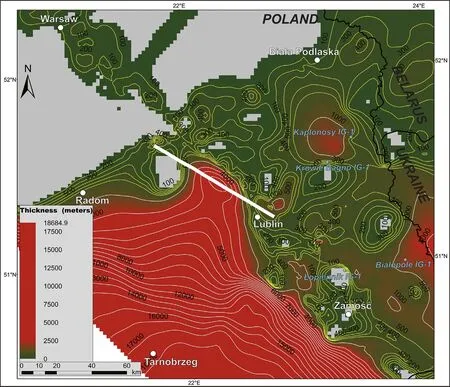
Fig.6 Neoproterozoic isopach map for the SW margin of the East European Craton in SE Poland(cf.Fig.1).Partly based on Mikołajczak(2016).White line—location of the seismic profile shown in Fig.4;blue dots—location of wells from Fig.3.The coordinate system,Poprawa et al.,1999,is based on the ETRS89 datum,GRS80 spheroid and the Transverse Mercator projection with 19°E as a central meridian.
The top of basement configuration in SE Poland,derived from inversion of gravity data shows the top of the EEC crystalline basement rapidly sloping toward the SW beneath the adjacent West European Paleozoic Platform and suggests crustal necking of the EEC crust coinciding with the Teisseyre-Tornquist Zone.Furthermore,an elongated graben extending in a NNESSW direction was revealed by the depth-to-basement and isopach maps that is coincident with the feature imaged in the seismic profile.Consequently,the Neoproterozoic isopach map provides an additional argument in favor of roughly simultaneous rifting in NE—SW and NW—SE directions,the latter ultimately leading to the opening of the Tornquist Ocean.
Acknowledgements
ION Geophysical is thanked for providing seismic data of the PolandSPAN®deep seismic survey.Analysis of gravity data was supported by the National Science Centre(NCN)(grant No.2012/05/B/ST10/00521).Two anonymous reviewers are thanked for valuable comments that helped to finally shape this paper.
 Journal of Palaeogeography2018年1期
- Journal of Palaeogeography的其它文章
- Late Triassic sauropodomorph and Middle Jurassic theropod tracks from the Xichang Basin,Sichuan Province,southwestern China:First report of the ichnogenus Carmelopodus
- Trace fossils of an amalgamated storm-bed succession from the Jurassic of the Kachchh Basin,India:The significance of time-averaging in ichnology
- Oxygenation in carbonate microbialites and associated facies after the end-Permian mass extinction:Problems and potential solutions
- Evolution of sedimentary facies and fossil communities in the Middle Permian Maokou Formation in Zigui County,Hubei Province,South China
- A redescription of the ichnospecies Koreanaornis anhuiensis(Aves)from the Lower Cretaceous Qiuzhuang Formation at Mingguang city,Anhui Province,China
- Geologic-seismic models,prediction of shallow-water lacustrine delta sandbody and hydrocarbon potential in the Late Miocene,Huanghekou Sag,Bohai Bay Basin,northern China
