Deep Continental Scientific Drilling Engineering Project in Songliao Basin: progress in Earth Science research
H-shng Hou, Chng-shn Wng, Jio-ong Zhng, Fng M, Wi Fu, Pu-jun Wng, Yong-jin Hung,Chng-hun Zou, You-fng Go, Yun Go, Li-ming Zhng, Jin Yng, Rui Guo
a Chinese Academy of Geological Sciences, Beijing 100037, China
b China University of Geosciences (Beijing), Beijing 100083, China
c Oil and Gas Survey, China Geological Survey, Beijing 100029, China
d Institute of Hydrogeology and Environmental Geology, Chinese Academy of Geological Sciences, Shijiazhuang 050061, China
e Jilin University, Changchun 130061, China
ABSTRACT
The Songke No.2 well (eastern hole) (referred to as Well SK-2), one of the “two wells and four holes” of the Deep Continental Scientific Drilling Engineering Project in the Songliao Basin, is in Anda City,Heilongjiang Province, and was officially completed on May 26, 2018. The scientific goals of Well SK-2 cover four aspects: paleoclimate research, resource and energy exploration, primary geological research,and development of deep earth exploration techniques. Since the official commencement of drilling in 2014, the Well SK-2 scientific drilling engineering team has organized and implemented drilling for coring, in situ logging, chemical analysis of core elements, and deep structural exploration around the well. Currently, the following preliminary scientific research progress has been made: 4334.81 m in situ core data has been obtained; the centimeter-level high-resolution characterization of the most complete and continuous Cretaceous continental strata ever unearthed has been completed, and the standard profile of continental strata has been initially established; the unconventional natural gas resources and basin-type hot dry rocks in the deep Songliao Basin were found to have good prospects for exploration and development; the climatic evolutionary history of the Cretaceous continental strata was rebuilt for the first time, covering hundreds of thousands to millions of years, and the major events of Cretaceous climate fluctuations have been discovered; all these reveal strong evidence for the subduction and aggregation of paleo-ocean plates, providing a theoretical basis for the re-recognition of the genesis of the Songliao Basin and for deep earth oil and gas exploration. The implementation of the Deep Continental Scientific Drilling Engineering Project in the Songliao Basin is of great significance for exploring the mysteries of the Earth and solving major problems such as those related to the deep energy environment. It is a solid step along the road of "going deep into the Earth".
Keywords:
Songliao Basin
Well SK-2
Deep energy resources
Cretaceous paleoclimate
Continental scientific drilling engineering
1. Introduction
Alongside the development of Earth System Science in recent years, there is a growing awareness of the importance of the close connection between the dynamic processes of Earth's interior and the process of surface geological evolution. The evolution of Earth, the formation of energy resources and the changes of environmental climate all originate from the deep earth (Dong SX et al., 2014). While developed countries started to launch deep earth exploration programs earlier than China and have had a series of major achievements (Oliver J et al., 1978, 1983; DEKORP Research Group, 1990; Echtler H et al., 1996; Knapp J et al., 1996;Berzin R et al., 1996; Clowes RMCM, 2010; Cook FA and Velden AJVD, 2012; Percival JA et al., 2012), China has followed the trend and completed a series of major deep explorations of its own (Zhao WJ et al., 2002; Yang WC et al., 2003; Dong SW et al., 2014; Gao R et al., 2011, 2016; Lü QT et al., 2015; Wei WB et al., 2010) in recent years. The ability to explore the deep earth has become a symbol of a country's comprehensive strength, but "going deep into the Earth" has meant the solving of strategic science and technology issues. Continental scientific drilling engineering,which acts like a telescope that enables the humans to see deeper into Earth, is an epoch-making invention in the contemporary field of earth sciences and is driving the current development of earth sciences and related disciplines (Xu ZQ,2004).
The International Continental Scientific Drilling Program(ICDP), led by China, the USA and Germany, was founded in 1996, and so far, has 24 members including 23 nations and UNESCO. The goal is to study the Earth's resources,environment and disasters in depth. Since its establishment,more than 100 continental scientific drilling wells of various depths have been drilled in 13 countries around the world(Wang PJ et al., 2017). Practice has proven that direct lithospheric sampling and observation through continental scientific drilling make it possible to understand plate movement in oceans and continents, crustal stress and seismic activity, volcanism, deep resources, the origins of life, and global environmental and climate change, solving a range of major fundamental scientific issues (Xu ZQ et al., 2004; Su DC and Yang JS, 2010). Up to now, China has successfully organized and implemented five continental scientific drilling projects (Xu ZQ et al., 2016), with the Deep Continental Scientific Drilling Engineering in the Songliao Basin being the third to be funded by ICDP in China. It is located within the Songliao Basin (Fig. 1), the large-scale Cretaceous continental sedimentary basin in central and eastern China and consists of Well SK-1 and Well SK-2 (Wang CS et al.,2013a, Fig. 2). The former was completed in 2007 and has produced several important research results (Wang CS et al.,2008).
With the strong support of the Ministry of Finance, the National Development and Reform Commission, the Ministry of Science and Technology and the Ministry of Education, the China Geological Survey under the Ministry of Natural Resources organized scientific researchers and drilling technicians who successfully completed the core drilling and logging of the 7018 m Songke No.2 well (Fig. 1, hereafter referred to as Well SK-2) in Anda City, Heilongjiang Province. Well SK-2 has become the deepest continental scientific exploration well completed by any Asian country,also the deepest to be drilled since the founding of the ICDP 22 years ago.
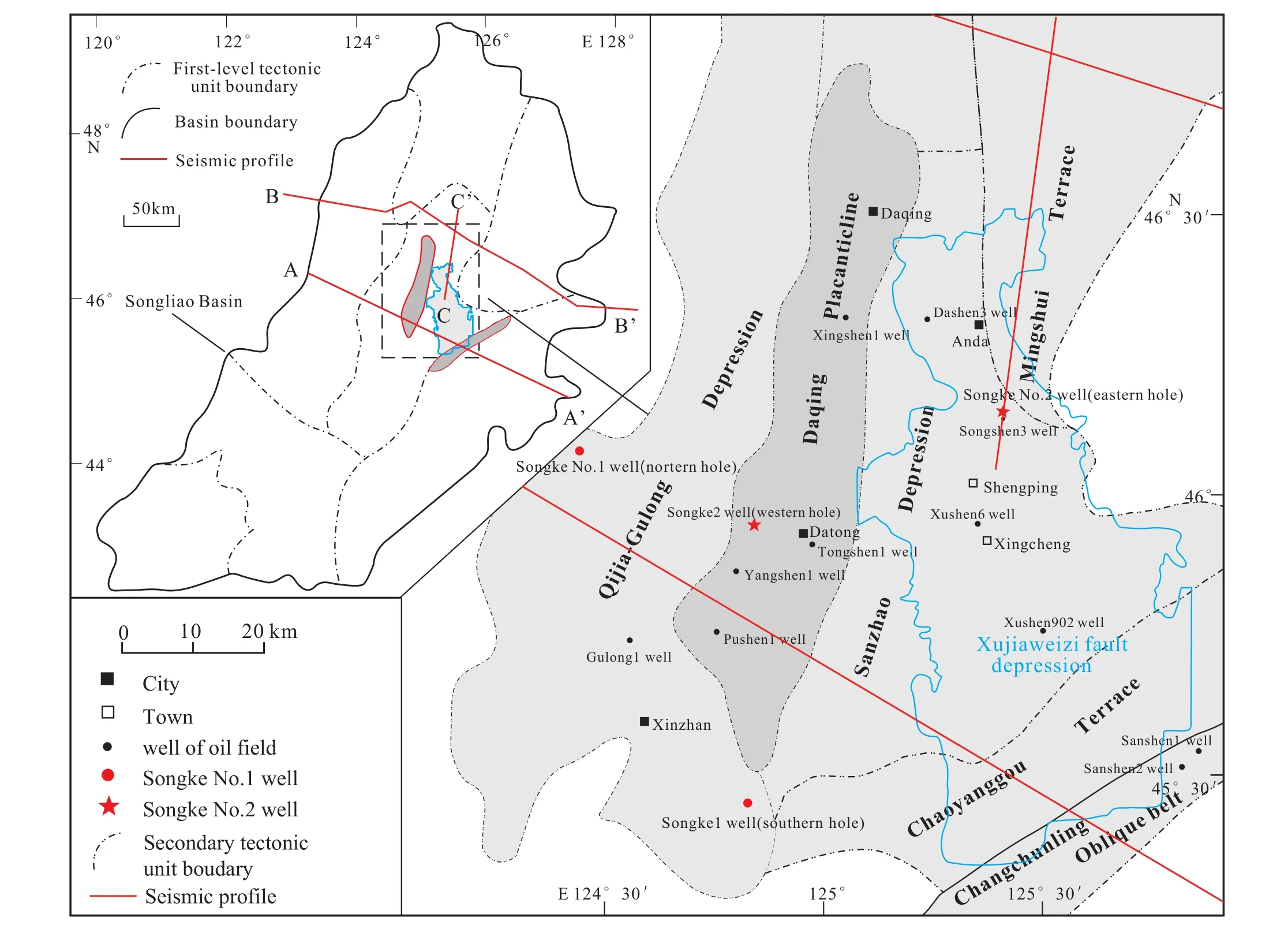
Fig. 1. Borehole distribution of the Deep Continental Scientific Drilling Engineering Project in Songliao Basin (modified from Wang PJ et al.,2017).
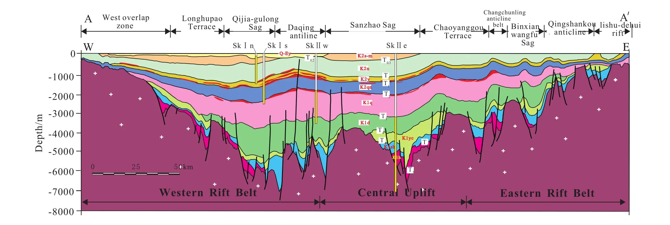
Fig. 2. Structural cross section across the central part of the Songliao Basin, based on regional seismic analyses and the borehole distribution of the Deep Continental Scientific Drilling Engineering Project (after Wang CS et al., 2013a).
The drilling of Well SK-2 started in April 2014 and was officially completed on May 26, 2018. Drilling for coring was the main objective of the project, with a drilling footage of 4279.73 m and a total core length of 4134.81 m, which allowed for a core recovery of 96.61%. Meanwhile, it was accompanied by in situ logging (Zou CC et al., 2016),geochemical analysis of core elements, and deep geophysical exploration techniques (deep seismic reflection profiling,regional gravity and magnetic survey, magnetotelluric sounding, etc.); thus, the Earth System Science research was undertaken in a combined "point-polyline-polygon" manner.
As the Deep Continental Scientific Drilling Engineering Project in the Songliao Basin features a huge research system,with many research institutes and researchers having participated in it, the massive amounts of data obtained is still under testing and analysis, and many research results still require further sorting. In combination with the previous"SinoProbe" special deep exploration results and the research results of Well SK-1, this paper is a brief summary of the phased scientific research progress and new discoveries achieved in Well SK-2, with a view to deepen the public understanding of the scientific goals and research significance of the Deep Continental Scientific Drilling Engineering Project in the Songliao Basin and to provide a reference for follow-up projects which require collaboration from similar engineering disciplines.
2. The scientific goals of Well SK-2 and its regional tectonic setting
The scientific goals of the Well SK-2 drilling engineering project are, firstly, to obtain continuous high-resolution continental geological records to form the basis for studying greenhouse-related climate changes and the genesis of largescale source rocks during the Cretaceous period and thus to establish the standard of continental Cretaceous strata.Secondly, it is to find important clues that can lead to deep energy resources, including deep clean energy and other alternative energy resources. Thirdly, it is to promote the progress of fundamental geological research, clarify the relationship between the formation of the Songliao Basin and deep tectonic evolution, and explore the genesis of the Daqing Oilfield and the terrestrial origin of petroleum theory.Fourthly, it is to obtain in situ and continuous geophysical parameters of the Songliao Basin up to a depth of 7018 m,which, combined with elemental chemical analysis and deep continental exploration techniques, can provide a scientific"scale" to the deep exploration of the Songliao Basin and its related similar basins.
It is important to clarify why we chose the Songliao Basin as the site of a drilling engineering project with such significance for scientific exploration. The location was determined by the unique geological evolution of the Songliao Basin and its basement. The Songliao Basin is located in the eastern part of the Central Asian Orogenic Belt (Sengör AMC and Natal’in BA, 1996), in the overlapping area of three major tectonic domains the Paleo-Asian Ocean, the Mongol-Okhotsk Ocean and the Pacific Ocean. The Cretaceous basement of the Songliao Basin is the Songnen massif. It is c.450-350 Ma ago that the Songnen massif entered a relatively stable period of tectonic evolution and developed its relatively complete Upper Paleozoic strata (Yu HZ, 2001; Wang CW et al., 2009). Many scholars believe that the sedimentary strata of this period also have oil and gas prospects (Zhang XZ et al., 2008; Ren SM et al., 2011; Zhang JF et al., 2018). With the closure of the Paleozoic Paleo-Asian ocean, the Songnen massif and its peripheral microcontinents were successively combined, and connected with the North China Plate along the Suolun-Xilamulun-Changchun suture zone in the Permian to Early Triassic (Hou HS et al, 2015; Liu YJ et al,2017; Zhou JB et al, 2017; Zhang XZ et al., 2015; Zhang FQ et al., 2008; Han GQ et al., 2008; Liang HD et al., 2016).From the Triassic to the Early Jurassic, the residual northern Mongol-Okhotsk ocean following the closure of the Paleo-Asian ocean appeared to undergo scissor-type closure from west to east (Yang YT et al. 2015; Wang T et al, 2015).Influenced by the after effects of the closure of the Paleo-Asian ocean, the early sedimentary strata generally suffered uplift and erosion, accompanied by massive volcanic activity.Then, in the Late Jurassic, different NE and SW plates showed multi-directional subduction and convergence towards the East Asian continent. What followed was intense continental lithospheric extension and volcanic magmatism in the Early Cretaceous (Dong SW et al., 2007), the precise time and the exact regional tectonic setting when and under which circumstances the Songliao Basin germinated (Cheng YH et al., 2016).
In the early stage of the basin’s evolution (syn-rift period,150-110 Ma, Wang PJ et al, 2016), the regional tensile stress led to the uplift of deep mantle, causing crustal fracture;accordingly, the basin basement fault blocks went through NW-SE splitting-off and non-uniform settlement (Hu WS et al., 2005), forming a range of segmented downfaulted (rift)basin groups. Mainly impacted by the Pacific tectonic domain in the middle and late stage of evolution (Wang PJ et al,2016), the basin entered the post-rift period (110-79.1 Ma),with very thick down-warped sedimentary sequences developed and being overlapped layer by layer to drape over the sedimentary sequences, or basement, of the downfaulted groups. Its subsidence mechanism is the superposition of the thermal flexural subsidence after the volcanic period, the collapse of the early magma chamber and subsidence due to regional strike-slip and pull-apart. In the following tectonic inversion period (79.1-64 Ma), the nearly positive subduction of the Pacific plate toward the Eurasian continental margin produced regional compressional stress, and thus the sedimentary and subsidence center of the basin migrated northwestwards and rapidly shrank and was entirely subducted; during this period, the strata show strong contemporaneous deformation. Therefore, the Songliao Basin went through a continuous 86 ma long basin evolution and sedimentation process. It is the great Cretaceous basin dominated by lacustrine fine-grained detrital sediments, with the longest development history, the largest sedimentary thickness and sedimentation rate throughout the world,recording abundant Cretaceous paleoclimatic evolution information (Wang PJ et al., 2017).
3. New clues for deep energy resource discovery
3.1. Exploration of deep unconventional natural gas resource potential
As the previous drilling in the Songliao Basin mainly targeted conventional oil and gas in the middle and shallow strata and the deep dense glutenite gas in the margins of fault depressions (Meng YL et al., 2012; Li CH and Yang JS, 2015;Feng ZF et al., 2015), few efforts had been made in regard to oil and gas surveys in sag zones in deep depressions, with a particular lack of full core drilling in the deep predominance development zone of source rocks in the Shahezi Formation and the Huoshiling Formation, which restricted the strategic orientation of exploration discovery and resource investigation. However, the drilling of Well SK-2 has revealed the potential of deep unconventional natural gas resources and so has provided an important basis for the expansion of deep energy exploration towards unconventional natural gas exploration.
Located at the sag zones in the Xujiaweizi fault depression, Well SK-2 has completely revealed the characteristics of the deep source rocks, and dark mudstone drilled in the Shahezi and Huoshiling Formations reaches a cumulative thickness of 1359.37 m, with the maximum thickness of a single layer reaching up to 23.21 m (Table 1).As the tested samples show, the organic carbon values of dark mudstone mostly exceed 1.0%, and the maximum temperatureTmaxof rock pyrolysis averages 505°C (Table 2). As per relevant technical specifications of unconventional natural gas(GB/T 30501-2014, GB∕T-31483-2015) and referring to previous data (Zhao ZH et al., 2016; Liu C, 2017), it is believed that the deep sag zones in the fault depression have organic-matter-rich strata which are large in accumulated thickness and high in abundance of organic matter, and are in the stage of high-mature to post-mature thermal evolution,providing the resource basis for deep unconventional natural gas surveying.

Table 1. The statistical table of the lithological thickness in the 450-5525 m interval of Well SK-2.

Table 2. Data table of hydrocarbon source rock analysis of the Shahezi Formation in Well SK-2.
Well SK-2 reveals favorable gas indications in a deep mud shale series of strata. The gas logging shows that the drilling of the Shahezi and Huoshiling Formations (3350 m depth)have revealed 118 layers with gas anomalies, with a cumulative thickness of 268 m and an abnormal ratio of gas logging averaging 8.33, with methane accounting for 96.8% of the total hydrocarbons, and the lithology being dominated by mudstone and glutenite (Fig. 3). The number of layers with abnormal ratios of gas logging more than 5 is 59 (Fig. 4). Out of those, 43 layers with gas logging anomalies are mud shale,which have a cumulative thickness of 102 m and an average ratio 14.77 of abnormal amplitude to background value (Fig. 5).All this indicates that the deep source rock series of strata in the Songliao Basin feature the "self-generation and selfreservoir" type of reservoir-forming conditions, which provides an important basis for the expansion in the Songliao Basin from the exploration of conventional oil and gas, also dense glutenite gas in depression margins to the exploration of unconventional natural gas in deep sag zones.
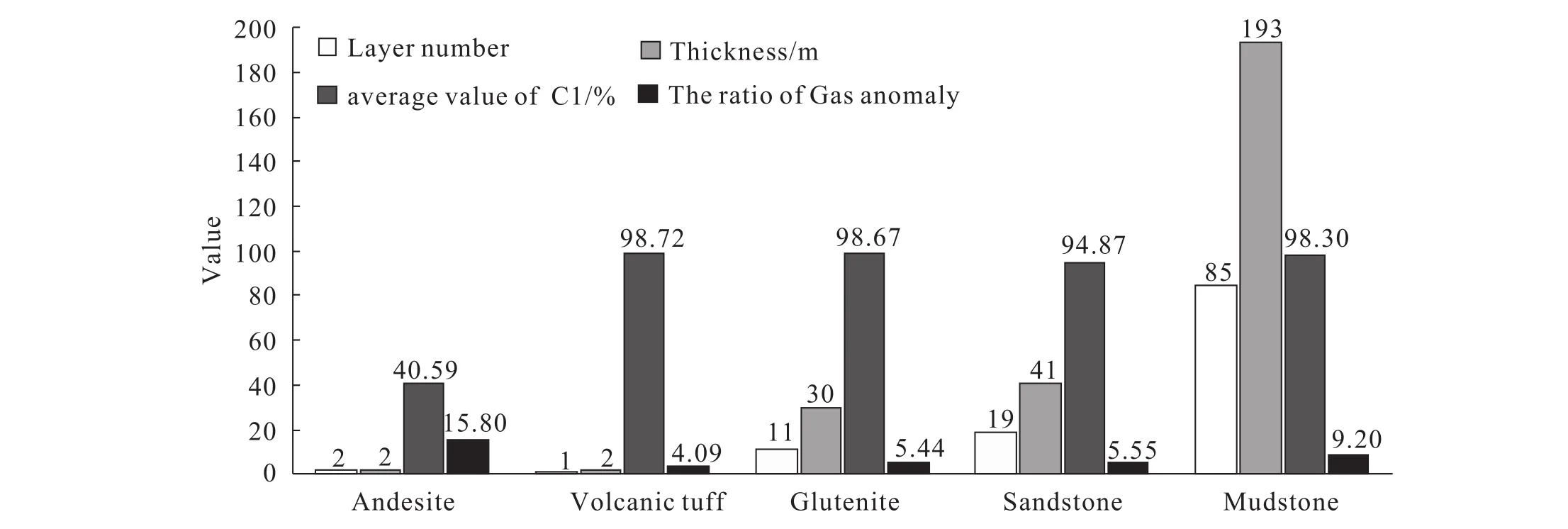
Fig. 3. The statistical histogram of gas logging abnormal lithology and the thickness of the Shahezi Formation in Well SK-2.
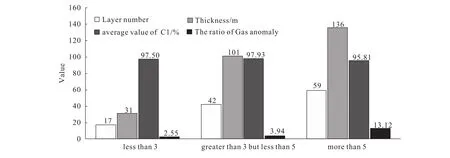
Fig. 4. The statistical histogram of gas logging abnormal ratio for Well SK-2.
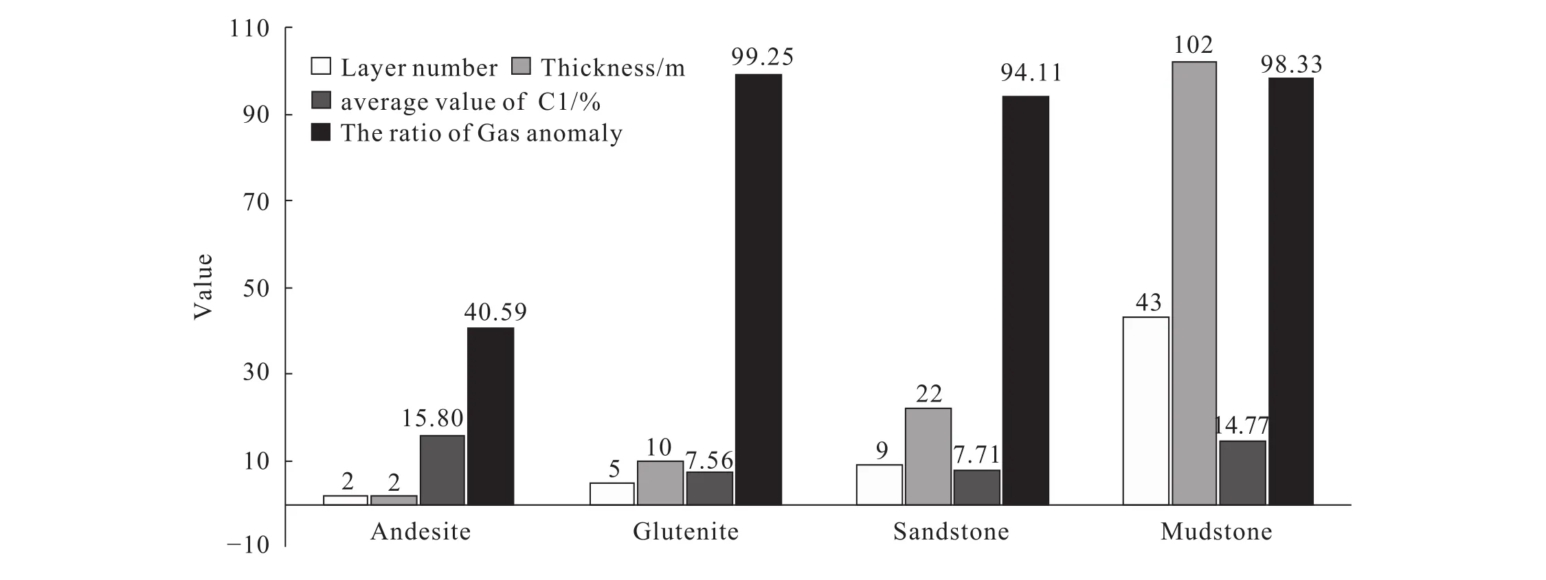
Fig. 5. The statistical histogram of gas logging abnormal lithology and the thickness of the Shahezi and Huoshiling Formation in Well SK-2(the abnormal ratio of gas logging is counted as those greater than 5).
3.2. The good occurrence of basin-type hot dry rocks
The Songliao Basin is a favorable target area for the development of China's oilfield geothermal energy and sedimentary-basin-type hot dry rocks. The basin has a structural mechanism favorable in deep thermal conduction and shallow thermal accumulation, indicating a good occurrence of geothermal resources. The multiple temperature logging results of Well SK-2 show that the basin has a relatively steep geothermal gradient, the geothermal flow value reaching 84 mW·m–2, and the geothermal anomalies are significant. At a depth of 4400 m into the basin, the temperature exceeds 150°C (Fig. 6), meeting the occurrence conditions of hot dry rocks.
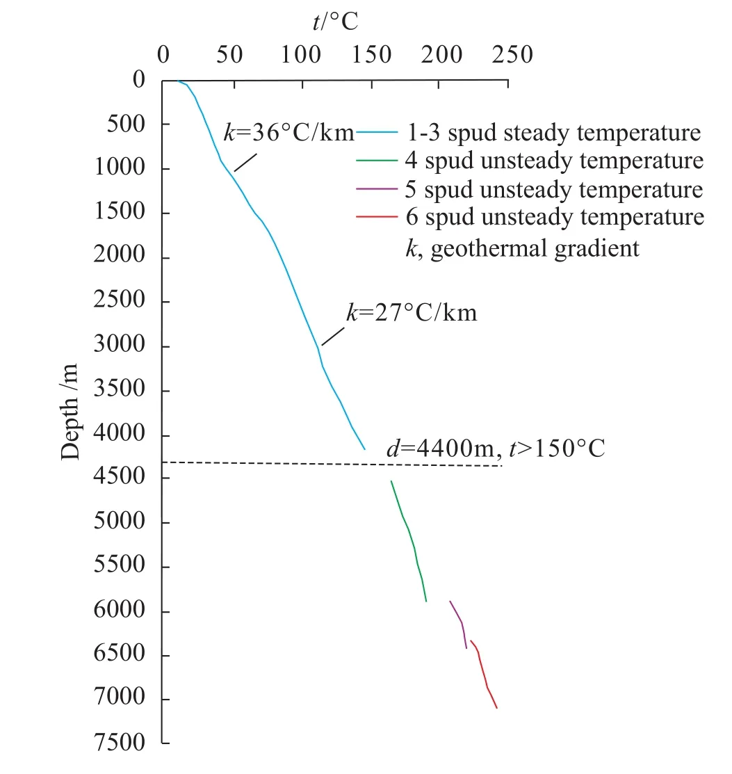
Fig. 6. Temperature log of Well SK-2.
The hydrothermal geothermal resources in the basin have an allowable exploitation quantity of 6.87×10⁷t/a, and as the oilfield development enters the middle and late stages, some oilfields produce up to 90% of the thermal water. This not only means great potential for geothermal exploration by taking advantage of the transformation of existing oil and gas wells, but also that the resources could be used for regional heat supply in winter, which could play an important role in energy conservation and emission reduction. Additionally, the amount of recoverable hot dry rock resources is equivalent to 7.4×10¹²t of standard coal. There are thirteen hightemperature granitic rocks in the range of the Daqing oilfield alone, covering an area of 1×10⁴km2and indicating great mining prospects. These resources may provide guarantees for future clean energy exploration in northeast China.
3.3. Clues for deep uranium ores
Three layers with highly radioactive uranium anomalies were discovered through radioactive logging (497.5 m-502.0 m in the Nenjiang Formation, mudstone with interlayered thin sandstone; 3096.8 m-3102.8 m in the Yingcheng Formation,the main lithology being variegated conglomerate; 3168.3 m-3170.9 m, the main lithology being conglomerate and rhyolitic breccia; as shown in Fig. 7, the cumulative thickness of the three layers is 13.1 m), which provides a major clue to the viability of uranium ore prospecting in the deep Songliao Basin. The genesis and occurrence of uranium ores still requires further exploration by combining previous research results (Jin RS et al., 2017).
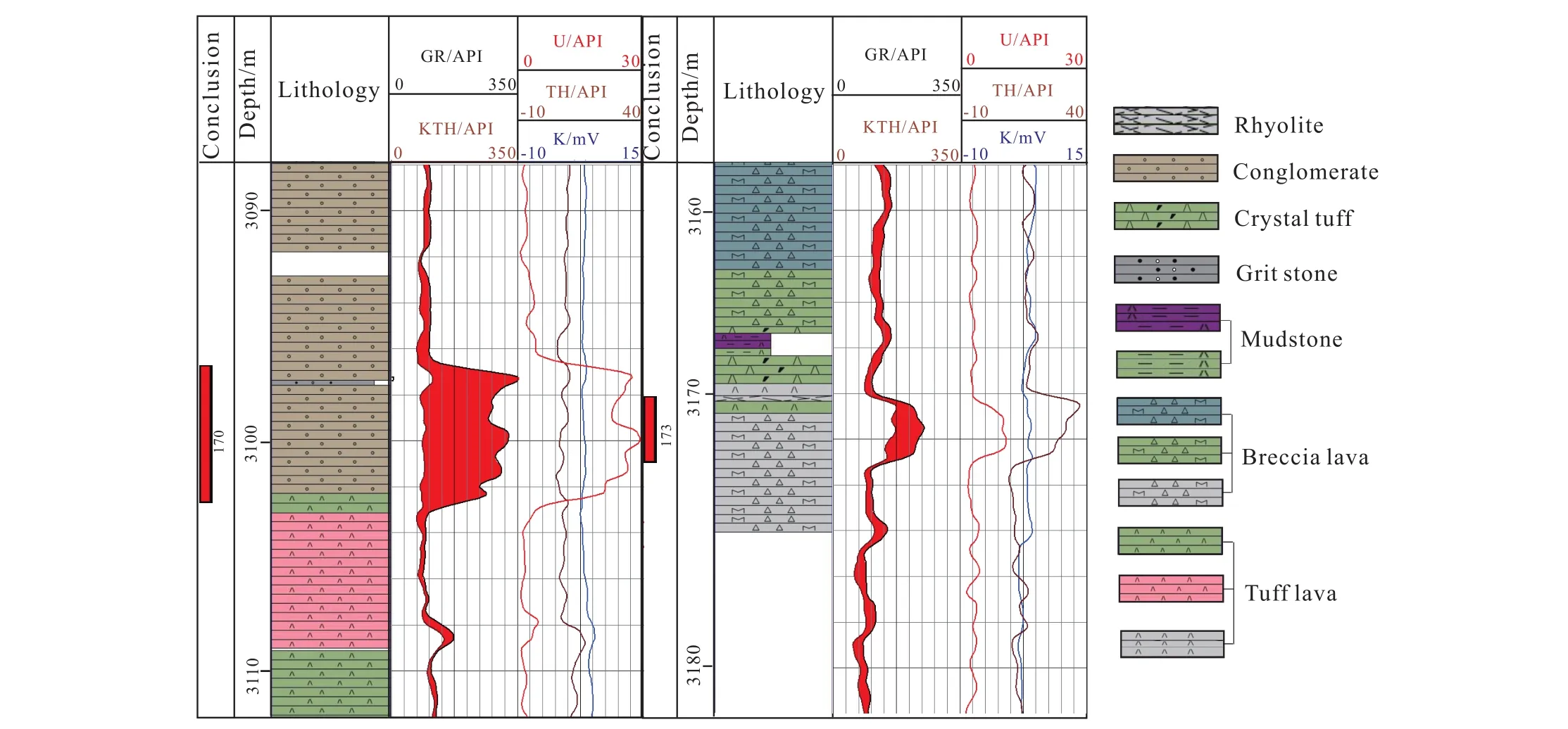
Fig. 7. The log response of two layers with radioactive anomalies in the Yingcheng Formation from Well SK-2.
4. Important understanding of the Cretaceous paleoenvironment and paleoclimate
4.1. The most complete Cretaceous continental geological record
So far, international efforts through the International Ocean Discovery Program (IODP) have been made in researches on responses related to marine Cretaceous climatic-environmental changes, with an abundance of results achieved (Larson RL and Erba E, 1999; Föllmi, 2012; O'Brien C et al., 2017). However, our understanding of the continental Cretaceous climatic-environmental changes tends to be partial or even incomplete, and furthermore, is seriously inadequate when it comes to the comparison and integration of the marine and continental aspects. The main reason for this is that the Cretaceous period was at a high sea level period globally (Kominz MA, 1984; Haq BU et al., 1987; Larson RL, 1991), when the global continental strata were not developed or undeveloped. Thus, it is hard to carry out marine and continental comparisons either regionally or globally(Parrish JT, 2001). As a result, well-preserved lacustrine sediments are the preferred target for the research and reconstruction of continental Cretaceous climaticenvironmental changes.
Due to the high sea level in the Cretaceous period, the global land area decreased, and the largest exposed land was in East Asia (Skelton PW and Spicer RA, 2003; Wang CS et al., 2008; Xiang F et al., 2015). Specifically, in the Songliao Basin in Northeast China, after its 85-90 Ma long-term evolution (Wang CC, 2013), Mesozoic and Cenozoic continental sediments have been accumulated and preserved with a total thickness of more than 10000 m (Daqing oilfield petroleum geology chronicle writing group, 1993; Wang DP et al., 1994). The Deep Continental Scientific Drilling Engineering Project in the Songliao Basin (Well SK-1 and Well SK-2) was implemented to obtain rock cores with a total length of 6 m-600 m and a time-span of 69 Ma, a greater length and time-span than any other international continental scientific drilling undertaking. At the same time, it is also honored as the "golden pillar" for the progress of "century-old Daqing" and basic geological services.
4.2. Climatic-environmental evolution during the continental Cretaceous period
The Cretaceous is a typical greenhouse climate period in"deep time" geological history, characterized by high atmospheric carbon dioxide concentration, high temperature,high sea level, and ice-free south and north poles (Skelton PW and Spicer RA, 2003). During the continental scientific drilling in the Songliao Basin, the curve of continental climate evolution under the Cretaceous environment with high atmospheric carbon dioxide concentration was plotted, which has important referential significance for us when it comes to understanding the current climatic global warming. The paleoclimatic-paleoenvironmental indicators show that in the Cretaceous "greenhouse climate", multiple time-scale climate fluctuations occurred in the mid-latitude lands of the northern hemisphere (O’Brien C et al., 2017; Föllmi KB, 2012). On the tectonic scale, the carbon and oxygen stable isotope curves of continuous ostracod fossils record the climate change and sedimentary evolution in the Songliao Basin with its relationship to global climate change (Chamberlain C et al.,2013; Wang CC, 2013). On the orbital scale,cyclostratigraphic analysis shows that changes in sedimentary characteristics, organic carbon and its isotopes are direct responses to changes in orbital parameters (Wu HC et al.,2013, 2014). Continuous coring ensured that several rapid climate change events were captured in the Deep Continental Scientific Drilling Engineering Project in the Songliao Basin.For example, during the global cooling period c.70 Ma ago,the oxygen isotope of the paleosol calcium carbonates showed a significant negative bias of about 3‰ in the middle part of the Mingshui Formation, which is the result of the synergy of the climate cooling in the Songliao Basin and the southward movement of the westerly wind belt in the Northern Hemisphere. This is the first time that this cooling event has been captured for the mid-latitude land area. Also, in the global warming period c.69-66 Ma, the negative bias of the carbon isotope of paleosol calcium carbonates indicates climate warming, enhanced paleosol respiration intensity, and increased precipitation in the Songliao Basin (Fig. 8; Gao Y et al., 2015).
In addition, according to the continental climate records near the reconstructed Cretaceous-Paleogene boundary, about 300 ka before asteroids hit the Earth, the temperature on the Earth and the carbon dioxide concentration in the atmosphere were both significantly high, highly concurrent with the volcanic eruptions on the Deccan Plateau. The research based on the continental records also found that about 2/3 of the species in the Songliao Basin were extinct after the Deccan volcanic eruptions and before the Chicxulub asteroid hit Earth. This shows that the Deccan volcanic eruption and the asteroid impact formed two consecutive blows that caused the extinction of species such as non-avian dinosaurs. First, the Deccan volcanic eruption caused drastic climate warming and an increase in carbon dioxide concentration, which destroyed the stability of the ecosystem and led to the extinction of some species. Thereafter, a short period of asteroid impacts caused the collapse of the already unstable ecosystem, being in this case the last straw that broke the camel's back (Zhang LM et al., 2018).
4.3. Formation of continental source rocks in the Songliao Basin and the transgression event
The very thick continental source rocks accumulated in the Songliao Basin provides the material basis for the longterm high-intensity exploitation of Daqing Oilfield. Its genetic mechanism has long been an outstanding major scientific issue in researches on the Songliao Basin. Through the implementation of the Deep Continental Scientific Drilling Engineering Project in the Songliao Basin, high-resolution multidisciplinary researches were carried out with the objective of obtaining core records of very thick source rocks in the Qingshankou and Nenjiang Formations, especially including research in the fields of paleontology, geochemistry and mineralogy. It was found that although the Songliao Basin was primarily a freshwater lake, both its water level and salinity increased during the sedimentation of the source rocks(Hou D et al., 2000; Huang YJ et al., 2013; Xi DP et al., 2011;Hu JF et al., 2015; Huang YJ et al., 2013), making it very difficult to interpret from the perspective of paleoclimatic change (Parrish JT, 2001), as the increase in lake salinity should generally correspond to lake regression and dry climatic conditions, while the opposite is true for the Songliao Basin. Establishing where the salt came from is the key to understanding the genetic mechanism of the source rocks in the Songliao Basin. The entry of seawater into the Songliao Basin can solve not only the problem related to increased salinity, but also provides a rational explanation for the genetic mechanism of the source rocks: with the entry of seawater, salinity stratification happened in the lake, and sulfate-reducing activity intensified due to the input of sulfates, thus leading to extensive hypoxia in the lake and a large-scale accumulation of organic matter, followed by the formation of large-scale source rocks. Relevant evidence includes the discovery of foraminifera (Xi DP et al., 2011),the emergence of marine biomarker compounds (Hu JF et al.,2015), pyritic sulfur isotope and morphological evidence(Huang YJ et al., 2013), and so on (Fig. 10). In considering the paleogeographic setting of the Songliao Basin adjacent to the Paleo-Pacific Ocean, the transgression channel at that time may have originated from the eastern or southeastern basin(Wang CS et al., 2013a; Hou D et al., 2000). According to the horizon distribution of foraminifera and the content changes of biomarker compounds, it was found that the entry of seawater was not continuous at the time but characterized by multiple event and short-term wave-type transgression. The specific control mechanism remains to be studied.
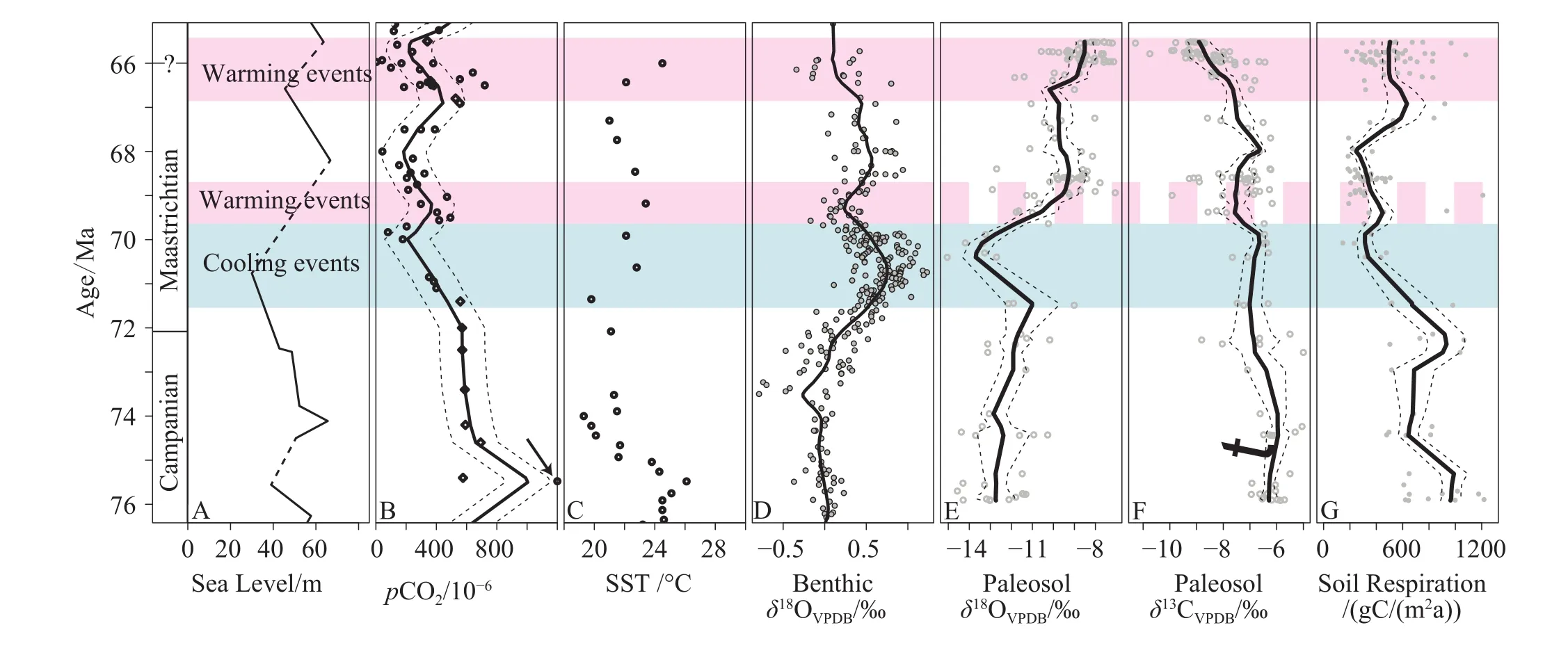
Fig. 8. Carbon-oxygen stable isotope curves of paleosol calcium carbonates in the Sifangtai-Mingshui Formation of the Songliao Basin and their correlations with global records (modified from Gao Y et al., 2015).
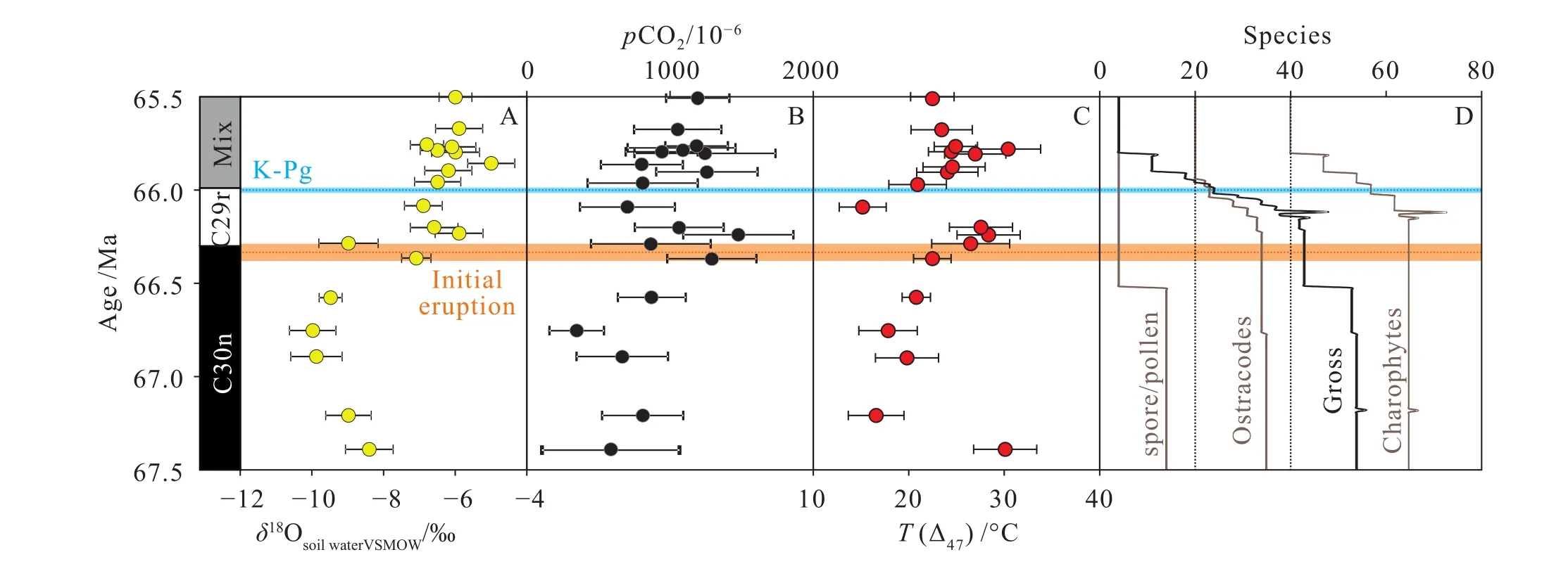
Fig. 9. Variation of temperature, CO2 and mass extinction at the Cretaceous-Paleocene boundary (after Zhang LM et al., 2018).
5. A new understanding of the deep stratigraphic structure
5.1. Fine deep framework
From the Well SK-2 drilling engineering, which obtained continuous and complete core data from the basement to the lower part of the Denglouku Formation, also the highprecision zircon U-Pb chronological data of rock samples from the Nenjiang and Yingcheng Formations: two age values obtained from the former were 83.35±0.11 Ma (1139 m) and 83.498±0.052 Ma (1142 m), and one from the Yingcheng Formation was 112.078±0.067 Ma (3266 m). In addition, at the basement 6371.2 m and 6373.9 m, the shallow metamorphic sandstone detritus was measured to have a zircon U-Pb age of 248.9±0.62 Ma (the only age peak, Early Triassic) and andesite was measured to have a zircon U-Pb age of 242.6±0.77 Ma (Middle Triassic), respectively. At the same time, the accurate core description results show that Well SK-2 reveals all four predicted rock types of the basement, namely shallow metamorphic sedimentary rock,altered volcanic rocks, dynamo metamorphic rock and granite,indicating that Well SK-2 has drilled down through the Cretaceous strata. According to the accurate core description results and the age data, the fine stratigraphic framework of Well SK-2 was preliminarily reconstructed (Fig. 11), which lays a foundation for the establishment of a "golden pillar" for the continental strata in the Songliao Basin.
5.2. The deep structure of the basin ridge and the dynamic process of deep energy occurrence
Just like the CT (Computed Tomography) technique used in medicine, deep seismic reflection profiling provides precise imaging of lithospheric structures up to 100 km deep within the Earth and has thus helped to achieve many little-known scientific discoveries. To reveal the deep geodynamic settings and the deep features of the energy occurrence structure in the northern Songliao Basin where Well SK-2 is located, a new SN-strike deep seismic reflection profile across Well SK-2(C-C' shows in Fig. 1) was collected. Combined with the structural characteristics (Fig. 12) of the deep seismic reflection profile (B-B' shows in Fig. 1) by SinoProbe across the main basin ridge in the Northeast China-Great Khingan-Songliao Basin-Lesser Khingan section, the Songnen massif was influenced by the scissor-type closure of the Mongol-Okhotsk ocean from west to east from the end of the Triassic to the Early Cretaceous (Zorin YA, 1999; Tomurtogoo O et al., 2005) and appeared to demonstrate eastward subduction and convergence (eastern dipping mantle reflection II, Fig. 12,Hou HX et al., 2015). Meanwhile, the eastern part of the Songnen massif suffered the western subduction of the Paleo-Pacific plate in the Late Mesozoic (western dipping mantle reflection III, Fig. 12), and its subduction may have begun in the Late Triassic (Zhou JB et al., 2009, Wu FY et al., 2011)and ended in the Late Cretaceous (Zhou JB et al., 2014).Therefore, the Songnen massif was in a two-way convergence in the Late Mesozoic which led to strong compression of the lithosphere to thicken, and later (Early Cretaceous), a huge extension and thinning was caused due to Earth's crust delaminating and mantle material upwelling (Wang T et al.,2011, 2012). All this is important information for the geodynamic setting for the formation of deep oil and gas reservoirs in the Songliao Basin.
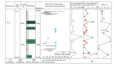
Fig. 10. A. Box-plot of pyrite framboids in Unit 1 of the Nenjiang Formation (stars mark the foraminifera-bearing layers); B. Correlations of organic geochemical data of Unit 1 of the Nenjiang Formation (after Hu D et al., 2015).
5.3. Deep structural basis of inorganic gas in the Songliao Basin
The organic or inorganic causes of oil and gas have been a subject of debate in the scientific community for many years.Gold T and Soter S (1980) proposed that mantle-derived methane continuously enters the crust through weak crustal zones, lithospheric plate boundaries, paleo-structural zones,meteorite impact zones and so on, and that during the slow upward migration and cooling process, methane forms hydrocarbon gases and petroleum of high molecular weight by polymerization. In recent years, it has been repeatedly reported both domestically and internationally that there is precise geochemical evidence to prove the inorganic genesis of carbon dioxide, methane and alkane hydrocarbon gas (Guo ZQ and Wang XB, 1997). It has also been found in the Songliao Basin that the natural gas produced by several gasproducing wells has non-biological genesis characteristics(Dai JX et al., 2008; Guo ZQ and Wang XB, 1997; Ni YY et al., 2009; Liu QY et al., 2014; Yang C et al., 2009).
The Qingshen gas field in the middle of the Xujiaweizi fault depression is a recently-discovered hydrocarbon-gasdominated industrial gas reservoir. Based on the analysis of the carbon isotope composition of the alkane gas produced in the gas field, Yang C et al. (2009) believe that some methane in the gas field is of inorganic origin. From the deep seismic reflection profile of the engineering deployment, it can be observed that there is significant Mohorovicic discontinuity(Moho) in the deep part of the Xujiaweizi fault depression,indicating that it is a magmatic belt of mantle scale and therefore that magmatism may lead to the upward migration of lots of methane gas of inorganic origin (Fig. 13) and to its accumulation in the basin fault depression. Due to space limitations, the discussion about the fine structural characteristics and dynamic environment of the lithosphere revealed by the deep seismic reflection profiling will be not be further expanded upon here and will instead be published elsewhere. Therefore, the south-north fine structural profile passing through Well SK-2 (Fig. 13) and the deep structure of the Great Khingan-Songliao Basin-Lesser Khingan section(Fig. 12) form a seismological basis for further research on,and evaluation of, the sources and resource predictions of gases of inorganic genesis in the northern fault depression of the Songliao Basin.
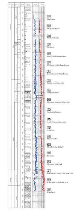
Fig. 11. Integrated core histogram of Well SK-2.

Fig. 12. The lithospheric cross section of the Songliao Basin from east to west. Mantle refection marked by Ⅱ and Ⅲ, dipping to each other, is found beneath the Songliao Basin. The mantle reflection is evidence of bi-directional plate subduction and convergence prior to the formation of the Songliao Basin. The location is shown in Figure 1 (B-B’). NJ FZ: Nenjiang fault zone.
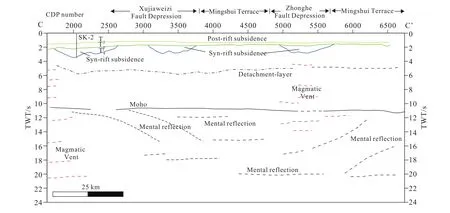
Fig. 13. Interpreted model from the deep seismic reflection profile trending north to south crossing Well SK-2. Location is shown in Fig. 1(C-C’). SK-2-Well SK-2; T2-top of Quantou Formation; T3-top of Yingcheng Formation; T42-bottom of Yingcheng Formation.
6. Conclusions and outlook on future work
The Deep Continental Scientific Drilling Engineering Project on the Chinese mainland is an important means by which to explore the mysteries of Earth and solve major problems such as those related to the deep resource environment. The success of the Well SK-2 project shows that China has made solid steps in the field of deep earth exploration. Meanwhile, with the centimeter-scale core data obtained, China has become a global leader in the global Cretaceous continental paleoclimatic field of study, and the deep energy clues discovered, have opened a new space in deep energy exploration and development. Up to now, the following scientific discoveries, understanding and preliminary scientific research progress have been made:
(1) The two clean energy sources in the deep Songliao Basin have been found to have good prospects for exploration and exploitation, including deep unconventional natural gas resources and basin-type hot dry rock strata with favorable exploitation conditions.
(2) Important geological history archives for the Cretaceous have been created, with the main controlling factors of continental climate change at various time scales discovered, and important information about the violent fluctuations of the Cretaceous continental climate captured,which are of great significance for further research and prediction of future global climate change patterns.
(3) New evidence of multiple-episode and short-term transgression events in the Songliao Basin have been discovered, and the new understanding that the Cretaceous transgression events were one of the important factors for organic matter enrichment and source rock formation have been developed, enriching the theory of the Cretaceous terrestrial origin of petroleum.
(4) A complete standard profile of the continental strata in the Songliao Basin, a "golden pillar", has been initially established, which provides an important continental "scale"or standard for the comparative study of regional and global strata.
(5) The deep geological structural characteristics of the Songliao Basin have been revealed, with deep evidence for the subduction and aggregation of paleo-ocean plates being discovered, and a new mechanism for intracontinental basin evolution from early basement two-way convergence to later extension and inversion has been constructed, providing the theoretical basis for recognition of the genesis of the Songliao Basin and for deep earth oil and gas exploration.
In the context of increasing social and public awareness of, and concern regarding, energy, resource and environmental issues, the systematic scientific research of the Well SK-2 Deep Continental Scientific Drilling Engineering project in the Songliao Basin clearly demonstrates its nature as "big science", characterized by interdisciplinarity, mutual interaction and even integration of various disciplines including geology, geophysics, paleontology, climatology and environmental studies; of different fields such as geodynamics, oil and gas resources and environmental changes; and of such different techniques as drilling, core handling, logging, geological recording and modeling. In this way, it reflects a new trend of earth systematic scientific research and technological development.
In the next phase, we will make full use of geological information such as core, well logging and test analyses obtained in the Well SK-2 (eastern hole), further the research on earth systematic scientific theories and methods and improve the overall quality of the results. We will also commence drilling Well SK-2 (western hole) as soon as possible, to provide a continuous and complete deep-time research "golden pillar" for the progress of "century-old Daqing", and to serve the aims of the exploration and exploitation of deep energy.
Acknowledgments
During project execution, Qing-tian Lü, the chief of the deep geological survey engineering, Shu-wen Dong, the chief scientist, academician Rui Gao, researcher Zong-li Huang,De-wu Qiao, professor Xing-zhou Zhang, Jian-bo Zhou and other experts give thoughtful guidance to us. China Geological Survey of leaders at all levels enhance the level of project research, concise, paid a hard sweat and wisdom. The editors of China Geology and two reviewers have put forward valuable opinions and suggestions. The authors wish to express our heartfelt thanks to the above experts, leaders and colleagues who are eager to offer help. This study was jointly supported by the Chinese Geological Survey Program(DD20160207, DD20189702), the National Natural Science Foundation of China (41474081) and the SinoProbe-02 program.
- China Geology的其它文章
- Main technical innovations of Songke Well No.2 Drilling Project
- Preliminary results of environmental monitoring of the natural gas hydrate production test in the South China Sea
- Episodic crustal growth in the Tanzania Craton: evidence from Nd isotope compositions
- Origin of natural sulfur-metal chimney in the Tangyin hydrothermal field, Okinawa Trough: constraints from rare earth element and sulfur isotopic compositions
- Exploration and research progress of shale gas in China
- Overview on hydrothermal and hot dry rock researches in China

