琼东南盆地北礁地区梅山组丘形反射特征
李俞锋,蒲仁海,胡宝清,樊笑微,李斌,邓东,王飞,郭瑞川
琼东南盆地北礁地区梅山组丘形反射特征
李俞锋1,2,蒲仁海1*,胡宝清2,樊笑微1,李斌1,邓东1,王飞1,郭瑞川1
(1.西北大学 大陆动力学国家重点实验室,陕西 西安710069;2.广西师范学院 北部湾环境演变与资源利用教育部重点实验室,广西 南宁530001)
目前琼东南盆地北礁凹陷中中新统梅山组顶部丘形反射引起广泛关注,但对其成因有不同认识。本文通过高精度二维、三维地震、钻井资料,研究丘形反射的特征。研究表明北礁地区梅山组顶部发育近东西向展布的长条形丘体,丘间为水道,丘内为中-弱振幅的地震反射,与西南部强振幅水道砂岩形成鲜明的对比,波阻抗反演揭示丘内为低波阻抗,属泥岩范畴。梅山组塑性丘内地层发生重力扩展,在其上覆的脆性地层(强振幅砂岩和弱振幅泥岩)发育多边形断层,反推出梅山组形成于深水环境,丘为泥丘,沉积环境分析也认为北礁凹陷中中新世为半深海沉积,梅山组的丘-谷分别对应上覆地层的谷-丘,认为是底流剥蚀/沉积成因。本文的研究对南海北部丘形反射的认识有重要意义,并可降低油气探勘风险。
北礁凹陷;梅山组;丘形反射;多边形断层;底流;泥丘;半深海沉积环境
1 引言
南海北部发育有多种丘形反射类型:砂岩侵入丘、泥底辟泥火山、火成岩丘、生物礁、重力流与等深流共同成因丘、沉积物波、等深积丘等[1-2];因此,对丘形反射的认识尤为重要,影响着古地理环境分析和油气钻探成功率等,如珠江口盆地南部低凸起之上的部分丘形反射初始被认为是生物礁成因,但钻井BY7-1-1却发现为这种酷似生物礁的丘形反射实则为凝灰岩火山丘。
北礁地区发育大面积分布的丘形反射[3-5],其中北礁凹陷中部YL19-1-1井钻遇的丘为泥丘,但在北礁凹陷东北部和南西部无钻井区的丘成因一直争议较大[6]。本文通过二维地震和约2 000 k m2的高精度三维地震资料,分析北礁地区梅山组顶部丘的振幅、波阻抗、断层、沉积环境等特征,并初步分析丘的成因。
2 区域地质背景
南海北部是西太平洋最大的被动大陆边缘海之一,琼东南盆地位于南海西北部,东靠珠江口盆地、北临海南岛(图1),是新生代断陷含油气盆地[7]。该盆地经历了3个演化阶段:始新世-晚渐新世裂陷期、早中新世-中中新世热沉降期和晚中新世以来的加速热沉降期[8](图1)。琼东南盆地主要分为东北-西南伸展的北部凹陷区、北部隆起区、中央坳陷区和南部隆起区4个一级构造单元[7](图1),研究区北礁凹陷位于松南低凸起和北礁凸起之间的中央坳陷区内,其丘形(状)反射区分布范围介于中央水道和北礁凸起之间(图1),且分布在中中新统梅山组上部,中新世以来盆地整体处于构造相对稳定的坳陷期,现今深水区约占整个盆地2/3,在南部隆起上局部发育生物礁[]。
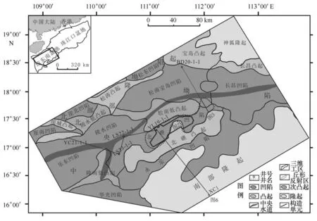
图1 琼东南盆地构造单元及工区位置图Fig.1 The tectonic elements and the location of the 3Dsurvey in the Qiongdongnan Basin
3 三维区地震属性特征
南海北部琼东南盆地中新世以来构造稳定,构造断裂基本不发育[10],中中新统梅山组顶面构造呈现出东南高西北低的构造格局,顶面具有近东西向长条形排列彼此相邻的丘和水道,延伸长度10~20 k m(图2a),这种丘和水道被认为是底流成因[3-5]。梅山组上段均方根属性显示中-低振幅且有0.2 k m左右的强振幅水道沉积(图2b),黄流组底部均方根属性仅在三维区南西部显示近东西向的长条形强振幅,其他三维区显示弱振幅(图2c)。
4 丘的波阻抗特征
通过测井(BD20-1-1)约束下的二维地震反演,显示丘内部波阻抗值为5.0×10⁶~6.5×10⁶kg/m3·m/s(图3),而含油气生物礁的波阻抗为8×106~12×106kg/m3·m/s,致密灰岩波阻抗更高超过10×106kg/m3·m/s,砂岩与灰岩的波阻抗界限在6×106~8×106kg/m3·m/s之间[5,11],说明研究区的丘形波阻抗属于砂泥岩的范畴,同时YL19-1-1等钻井揭示该丘岩性为泥岩和钙质泥岩[4-5],这些似乎也都说明丘为泥丘。
5 北礁凹陷中新统多边形断层特征
目前各沉积盆地发现的多边形断层主要集中发育在被动大陆边缘盆地的细粒沉积物(如泥岩)中[12];通过多边形断层推测中央坳陷区的华光凹陷梅山组古地理环境为深水饥饿沉积环境[13],同时有学者认为琼东南盆地多边形断层多发育于深水盆地泥岩中[14]。处于中央坳陷区的华光凹陷、北礁凸起、长昌凹陷中新统地层中均发育多边形断层[15]。北礁凹陷处于上述凹陷的过渡区,前人研究也预测了该处中新统发育多边形断层[16]。黏土矿物中的蒙脱石含量在黄流组比梅山组低[17],其中在黏土矿物中蒙脱石含水性最好,比表面最大,具有蒙脱石含量越高,塑性指数越大,塑性越强的特点[18-19],这似乎意味着梅山组泥岩塑性很可能比黄流组泥岩塑性强,即梅山组比黄流组更易发生滑动变形。
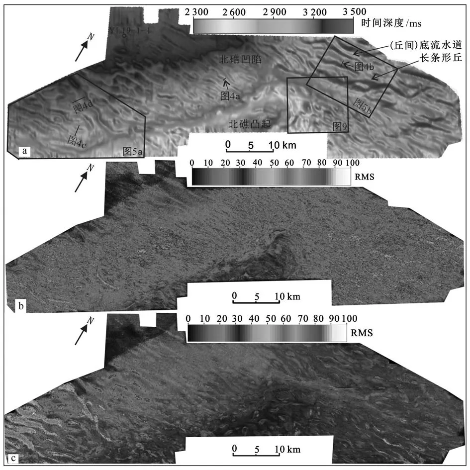
图2 琼东南盆地北礁三维区地震属性图(平面位置见图1)Fig.2 The various seisi mic attribute in 3Dsurvey in the Beijiao Sag of Qiongdongnan Basin(location is shown in Fig.1)a.北礁三维区梅山组顶面时间域构造图;b.梅山组上段(丘内)均方根属性图;c.黄流组底部均方根属性图a.The ti me structure map of the top of the Meishan For mation in Beijiao Sag survey;b.the RMSattribute map of the upper Meishan For mation in Beijiao Sag survey;c.the RMSattribute map of t he bottom Huangliu For mation in Beijiao Sag survey
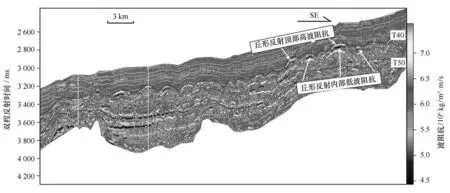
图3 琼东南盆地丘和水道二维测线波阻抗反演(剖面位置见图1)Fig.3 The 2D wavei mpedance section for the remnant mound and channel area(location is shown in Fig.1)
一般认为多边形断层发育在细粒沉积物中,但近年来发现在深水砂岩中也发育多边形断层[12],深水砂体多边形断层被认为是其下伏塑性沉积物(泥岩)在重力扩展作用中形成的[20]。Victor和Moretti[20]在模拟深水水道砂岩多边形断层的实验中观察到在重力扩展作用下多边形断层在丘形堤岸上方地层中集中发育(形成断层密集带)和在水道上方发育横截断层。吴时国等[14]对重力扩展形成的多边形断层进行了详细的描述,重力扩展初始阶段,先形成垂直水道的横截断层,随着重力扩展的继续进行,在丘形堤岸上方发育平行水道走向的断层密集带[14,20],这似乎提供了可通过水道砂岩中的多边形断层反推水道下伏为深水沉积环境和塑性泥岩地层的方法。
5.1 丘与多边形断层特征
黄流组底部地层在丘顶上方发育多边形断层密集带(图4,图5a、b),其中三维工区东北部丘间弱振幅水道泥岩充填(图4a、b),三维南西区丘间强振幅砂岩充填(图4c、d)。无论是泥岩还是砂岩充填水道,都有丘规模越大,多边形断层密集带越发育的特点,即图4b1、d1分别比图4a1、c1多边形断层发育,延伸长度较长。断层密集带的破碎地层,易形成杂乱反射,其平面的相干属性显示(灰黑色)低相干(图5a、b)。

图4 琼东南盆地梅山组丘顶上部断层密集带发育特征图(剖面位置见图2)Fig.4 The characteristics of the fault concentrated belts above the mound top of Meishan For mation(location is shown in Fig.2)a、b和c、d分别为工区东北部(丘间弱振幅泥岩区)和西南部(丘间强振幅砂岩区)的原始地震剖面,a1、b1和c1、d1对应的多边形断层密集带解释剖面Unexplained seismic sections a,b and c,d,arein the northeast survey(weak amplitude mudstone area bet ween the mounds)and the southwestern survey(strong amplitude sandstone zone bet ween the mounds),respectively,and theinterpretation section of the polygonal fault concentrated belts corresponding to a1,b1 and c1,d1
5.2 丘-水道与多边形断层平面特征
多边形断层在受到构造应力、刺穿盐丘、斜坡、水道、泥底辟等的影响下,不一定呈现出多边形形态[21],多边形断层在伴有水道发育的地层中,先发育垂直水道的断层形成横截多边形断层,后在丘形堤岸上方发育多边形断层密集带[20]。
北礁三维西南区强振幅水道砂岩连续性好(图4c、d),其水道显示高相干(灰白色),呈长条形近西向展布,高相干水道上方发育横截水道断层(图5a),丘顶上方发育断层密集带(图4c、d,图5c),其平面显示低相干(灰黑色)(图5a),呈长条形近东西向展布。在北礁三维东北区也有相同的特点(图5b、d),只有在塑性较大的地层发生重力扩展作用时,其上覆地层才能形成多边形断层密集带和横截水道断层[20],这些特征似乎也说明下伏梅山组丘岩性为塑性较大的深水泥岩。

图5 琼东南盆地北礁凹陷多边形断层发育特征图(平面位置见图2a)Fig.5 The characteristics of the polygonal faults in Beijiao Sag of Qiongdongnan Basin(location is shown in Fig.2a)
6 丘形反射岩性特征及中中新世沉积环境分析
钻井揭示位于北部隆起的YC21-1-1井中新统以滨浅海砂岩沉积为主,位于南部隆起的XC1井中新统为碳酸盐岩沉积,发育生物礁,属于碳酸盐岩的浅水台地沉积环境,而位于中央坳陷的LS33-1-1、LS22-1-1、YL19-1-1井中新统以泥岩为主,属于半深海相(图6)。琼东南盆地通过浅水区和深水区20口井,结合二维地震井网密度4 k m×2 k m,分析其北礁凹陷中中新世沉积厚度较大(图7a),约150~300 m,梅山组顶部丘形体形成环境应属于半深海的沉积环境(图7b)。
7 中中新统丘-谷地震反射分别对应上中新统谷-丘地震反射特征
一些学者在研究爱尔兰西南部Porcupine盆地底流丘形沉积物时,发现底流切割成因的丘-谷底形,分别对应上覆底流沉积成因的谷-丘形态,即丘对应上覆地层的谷,谷对应上覆地层的丘(图8),且这类地震反射通过钻井证实为底流成因[22],同时这类地震反射在南海北部神狐附近也有发现[23],也被解释为底流成因。
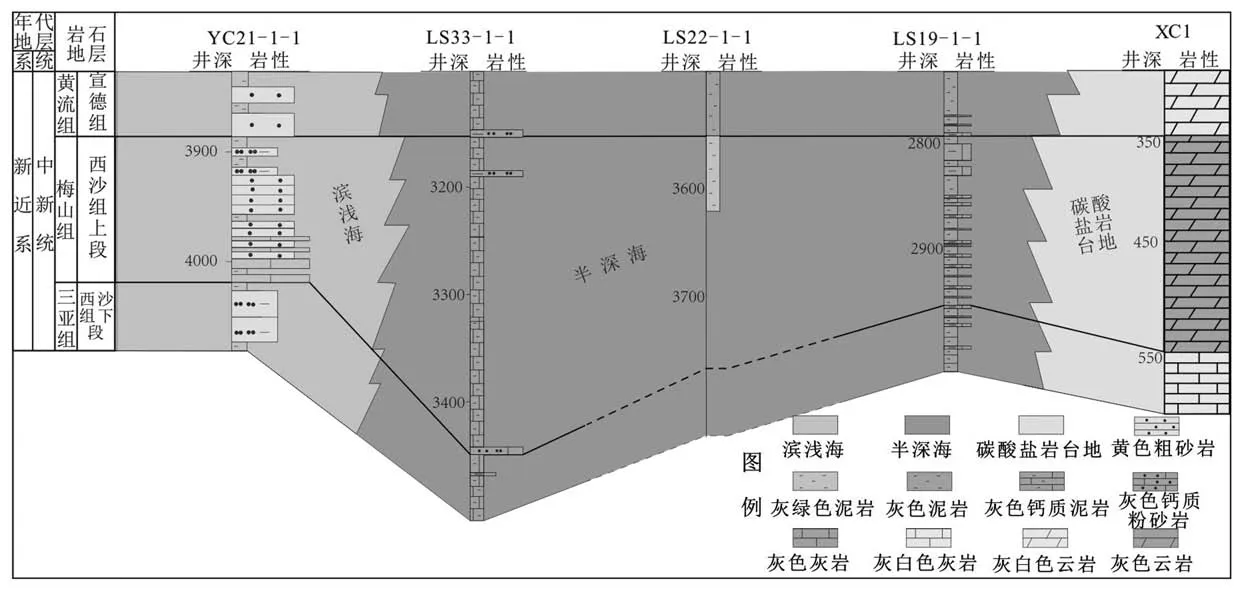
图6 琼东南盆地中中新统沉积相对比(位置见图7b)Fig.6 The comparative section of sedi mentary facies for connecting wells of the Mid-Miocene For mation in the Qiongdongnan Basin(location is shown in Fig.7b)

图7 琼东南盆地梅山组厚度(a)及沉积相(b)Fig.7 The isopachous(a)and sedi mentary facies(b)of the Meishan For mation in the Qiongdongnan Basin
北礁凹陷中中新统顶部丘在平面上呈长条形近东西向展布(图2a),与Stuart和Huuse[24]研究北海底流切割成因的丘形反射的平面特征相似,且南海北部中新统已经发现底流切割成因的长条形丘,即底流底蚀下伏地层形成底流水道,水道间呈丘[25],推测南海北部最早底流侵蚀切割可追溯至早中新世晚期[25]。南海西北部稳定的底流沉积或侵蚀作用可追溯至晚中新世早期(11.5 Ma BP)[26],北礁凹陷中中新统丘状反射有明显的削截现象(图8a、b),晚中新世早期底流活动加剧,底蚀下伏地层,形成底流水道(谷),水道间为残留地层——(残)丘,之后由于底流活动减弱,在谷内沉积受底形限制的丘形漂积体(图8a)。底流沉积常受底形的控制,底形的“凹凸不平”也常引起上覆地层底流沉积物的“凹凸不平”,在谷内形成局限丘形漂积体或充填丘形漂积体,其地震反射特征呈丘状反射[22,27]。梅山组底流水道流速减弱,沉积速率大于剥蚀速率,形成充填型丘形漂积体(图8a),继承性发育至今,而梅山组丘顶之上,流速较快,相对底流水道,沉积速率小,其上最终形成底流水道(谷),梅山组上覆的底流水道有继承性的发育,有迁移剥蚀现象(图8b),部分水道中发育强振幅浊流沉积。这样就形成了中中新统梅山组的谷-丘地形分别对应晚中新统黄流组的丘-谷地形,是底流前期剥蚀后期沉积的继承性的结果,在研究南海北部底流沉积/剥蚀应引起足够的重视。梅山组丘X(图9a)对应黄流组谷Y(图9b),水道的迁移现象使得梅山组底流水道(谷)对应黄流组丘有一定的偏移(图9c)。这些特征似乎也说明了梅山组顶部丘更大的可能为底流相关成因。
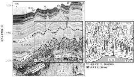
图8 北礁凹陷底流底蚀和沉积相关的谷-丘互相对称形态特征(a)及局部解释(b)(剖面位置见图9a)Fig.8 The characteristics of the mound-trough morphology originated fromthe incision and deposition of the botto m current in the Beijiao Sag of Qiongdongnan Basin(a)and localized section explained(b)(location is shown in Fig.9a)
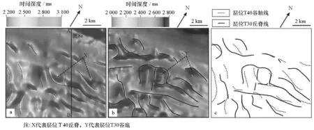
图9 琼东南盆地北礁凹陷三维区的(梅山组顶部)层位T40(a)和(黄流组顶部)层位T30(b)的长条形丘相关谷-丘互相对称关系(c)平面图Fig.9 The characteristics of the ridge-trough morphology(c)about elongated small hu mmocks on(the top of Meishan For mation)reflection T40(a)and(the top of Huangliu For mation)reflection T30(b)in the Beijiao Sag of Qiongdongnan Basin
8 丘形体特征讨论
北礁地区丘内为中-弱振幅地震反射(图2b),与西南部强振幅水道砂岩和北东部弱振幅水道泥岩形成鲜明的对比(图4),同时波阻抗反演显示丘内为低波阻抗,与强振幅高阻抗的生物礁、火山丘形成鲜明的对比。北礁地区长条形丘平面延伸10~20 k m,YL19-1-1井钻遇的丘及其附近的丘平面延伸长度较长(图2a),部分可延伸至西南区和东北区,这些丘与YL19-1-1钻遇的丘应该属于同一种成因,即泥质成因。梅山组发育丘地层的重力扩展形成上覆地层的多边形断层密集带(纵向断层)和横截水道断层(横向断层)(图5),也说明了丘内为塑性较大地层,这也进一步增大了丘内为泥岩的可能性。对琼东南盆地中中新世沉积环境分析也认为北礁凹陷为半深海沉积(图6,图7),这也进一步认为丘内地层形成于深水环境中。梅山组顶部的丘-谷底形对应上覆地层的谷-丘地形,并伴有谷(水道)的迁移和浊流沉积(图8),南海北部在早中新统晚期已发现活跃的底流[26],活跃的底流能塑造海底地形,对于该区谷-丘地形,作者认为是底流前期底蚀切割,后期沉积而形成,这样的解释也较为合理。然而工区临近生物礁发育的西沙地区,有学者把该区丘解释为生物礁也有理论依据,无论该区丘被解释为泥质丘还是生物礁都是一种推测,还需要后期钻井进一步证实。对于本文利用多边形断层识别丘的(形成于深水)沉积环境和岩性(由泥岩组成),同时梅山组的丘-谷底形分别对应上覆地层的谷-丘地形这类地质现象,被解释为底流成因,希望能引起学者的关注。
9 结论
(1)北礁凹陷梅山组顶部丘近东西向长条形展布,近平行排列,延伸10~20 k m,丘间为水道,丘内为中-弱振幅的地震反射,与东北部弱振幅水道泥岩和西南部强振幅水道砂岩形成鲜明的对比。
(2)通过波阻抗反演揭示,丘内为低波阻抗,与高波阻抗火山丘和生物礁形成鲜明的对比,该丘应属于泥岩的范畴。
(3)梅山组塑性地层发生重力扩展,在其上覆(黄流组)相对脆性地层(北东部弱振幅水道泥岩和南西部强振幅水道砂岩)发育多边形断层,即堤岸上方断层密集带和水道上方横截水道断层,推测丘内为塑性较大的泥丘,形成于深水环境。
(4)琼东南盆地的钻井资料和中中新统沉积厚度分析认为,北礁凹陷中中新世为半深海沉积,丘为泥丘。
(5)梅山组顶部丘-谷分别对应上覆黄流组谷-丘,认为是底流剥蚀/沉积的结果,梅山组丘为底流剥蚀残留地层—(残)丘。
致谢:在此衷心感谢三位审稿专家和编辑提出的宝贵的修改意见!
[1] 伊万顺,邓艳涛,狄邦让.琼东南盆地南部隆起带丘状地震相成因讨论[J].石油物探,2012,51(2):199-203.Yi Wangshun,Deng Yantao,Di Bangrang.Discussion on the genesis of domal reflections at the uplift zone of the souther n Qiongdongnan Basin[J].Geophysical Prospecting for Petroleu m,2012,51(2):199-203.
[2] 杨波,张昌民,李少华,等.珠江口盆地大型丘状地质体地震相分析及地质解释[J].石油学报,2014,35(1):37-49.Yang Bo,Zhang Changmin,Li Shaohua,et al.Seismic facies analysis and geological interpretation of large-scale moundsin Pearl River Mout h Basin[J].Acta Petrolei Sinica,2014,35(1):37-49.
[3] 赵天亮,蒲仁海,屈红军,等.琼东南盆地南部中新统“丘”形反射成因探讨[J].海洋学报,2013,35(4):112-120.Zhao Tianliang,Pu Renhai,Qu Hongjun,et al.An origin discussion of mound-shaped reflections in Miocene,southern Qiongdongnan Basin[J].Haiyang Xuebao,2013,35(4):112-120.
[4] 蒲仁海,屈红军,吴晓川,等.南海北部中新统的等深流成因的丘形与水道沉积[C]//第十七届中国科协年会论文集-分9南海深水油气勘探开发技术研讨会论文集.北京:海洋出版社,2015:1-18.Pu Renhai,Qu Hongjun,Wu Xiaochuan,et al.The Miocene mound and channel reflections originated from contourite in Northern South China[C]//17th annual meeting of china association for science and technology-Breakout 9:Proceedings of t he Sy mposiu mon deepwater oil and gas exploration and develop ment in t he South China Sea.Beijing:China Ocean Press,2015:1-18.
[5] Tian Jie,Wu Shiguo,Lv Fuliang,et al.Middle Miocene mound-shaped sedi ment packages on the slope of t he Xisha carbonate platfor ms,Sout h China Sea:Combined result of gravity flow and bottom current[J].Deep Sea-Research PartⅡ:Topical Studies in Oceanography,2015,122(6):172-184.
[6] 李俞锋,蒲仁海,屈红军,等.琼东南盆地北礁凹陷梅山组顶部丘形反射特征及成因分析[J].海洋学报,2017,39(5):89-102.Li Yufeng,Pu Renhai,Qu Hongjun et al.,The characteristics and genesis analysis of the mound at the top of Meishan For mation in the Beijiao Sag of the Qiongdongnan Basin[J].Haiyang Xuebao,2017,39(5):89-102.
[7] 雷超,任建业,裴健翔,等.琼东南盆地深水区构造格局和幕式演化过程[J].地球科学:中国地质大学学报,2011,36(1):151-162.Lei Chao,Ren Jiangye,Pei Jianxiang,et al.Tectonic framewor k and multiple episode tectonic evolution in deep water area of Qiongdongnan Basin,northern continental margin of South China Sea[J].Eearh Scince:Journal of China University of Geoscience,2011,36(1):151-162.
[8] Xie Xinong,Müller R D,Li Sitian,et al.Origin of anomalous subsidence along the Nort hern South China Sea margin and its relationship todynamic topography[J].Marien and Petroleu m Geology,2006,23(7):745-765.
[9] 于亚苹,刘立,徐守立,等.西沙群岛西科1井梅山组一段储层物性特征及储集评价[J].世界地质,2015,34(4):1069-1078.Yu Yaping,Liu Li,Xu Shouli,et al.Reservoir characteristics and evaluation of the first member of Meishan For mation in Well Xike 1,Xisha Islands[J].Global Geology,2015,34(4):1069-1078.
[10] 陈宏言,孙志鹏,翟世奎,等.琼东南盆地井震地层对比分析及区域地层格架的建立[J].海洋学报,2015,37(5):1-14.Chen Hongyan,Sun Zhipeng,Zhai Shikui,et al.Analysis of well-seismic stratigraphic correlation and establish ment of regional stratigraphic framework in the Qiongdongnan Basin of northern South China Sea[J].Haiyang Xuebao,2015,37(5):1-14.
[11] 吴时国,袁圣强,董冬冬,等.南海北部深水区中新世生物礁发育特征[J].海洋与湖沼,2009,40(2):117-121.Wu Shiguo,Yuan Shengqiang,Dong Dongdong,et al.The miocene reef develop ment charateristics in norther n South China Sea[J].Oceanologia et Li mnologia Sinica,2009,40(2):117-121.
[12] Stuevold L M,Faerseth R B,Arnesen L,et al.Polygonal faultsin the Or men Lange Field,More Basin,offshore Mid Nor way[J].Geological Society London Special Publications,2003,216(1):263-281.
[13] Yuan Shenghe,Yao Gengsun,Lv Fuliang.Features of late Cenozoic deepwater sedi mentation in southern Qiongdongnan Basin,northwester n Sout h China Sea[J].Journal of Earth Science,2009,20(1):172-179.
[14] 吴时国,孙启良,董冬冬.深水盆地中多边形断层的几何特征与形成机制探讨[J].地质力学学报,2008,14(3):231-240.Wu shiguo,Sun Qiliang,Dong Dongdong.The geometrical characteristics and for mation mechanism of polygonal faults in deep-water basin[J].Journal of Geo mechanics,2008,14(3):231-240.
[15] 陈端新,吴时国,王志君,等.南海北部陆缘深水盆地多边形断层几何特征及成因[J].石油学报,2012,33(4):610-616.Chen Duanxin,Wu Shiguo,Wang Zhijun,et al.Geometry and genesis of polygonal faultsin epicontinental deepwater basins,northern South China Sea[J].Acta Petrolei Sinica,2012,33(4):610-616.
[16] 孙启良,吴时国,陈端新,等.南海北部深水盆地流体活动系统及其成藏意义[J].地球物理学报,2014,57(12):4052-4062.Sun Qiliang,Wu Shiguo,Chen Duanxin,et al.Focused fluid flow systems and their i mplications for hydrocarbon and gas hydrate accu mulationsin the deep-water basins of the northern South China Sea[J].Chinese Journal of Geophysics:Chinese Edition,2014,57(12):4052-4062.
[17] 万世明,李安春,胥可辉,等.南海北部中新世以来黏土矿物特征及东亚古季风记录[J].地球科学:中国地质大学学报,2008,33(3):289-300.Wan Shi ming,Li Anchun,Xu Kehui,et al.Characteristics of clay minerals in t he nort hern South China Sea and its i mplications for evolution of east Asian monsoon since Miocene[J].Earth Science:Journal of China University of Geosciences,2008,33(3):289-300.
[18] 范二平,唐书恒,姜文,等.简述黏土矿物对页岩气储层的影响作用[EB/OL].(2013-06-08)[2016-12-12].http://www.paper.edu.cn/releasepaper/content/201306-112.Fan Erping,Tang Shuheng,Jiang Wen,et al.Impact of clay minerals on shale gas reservoirs[EB/OL],(2013-06-08)[2016-12-12].http://www.paper.edu.cn/releasepaper/content/201306-112.
[19] Wilson MJ,Wilson L.Clay mineralogy and shale instability:an alternative conceptual analysis[J].Clay Minerals,2014,49(2):127-145.
[20] Victor P,Moretti I.Polygonal fault systems and channel boudinage:3Danalysis of multidirectional extensionin analogue sandbox experi ments[J].Marine and Petroleu m Geology,2006,23(6):777-789
[21] Cart wright J A.Diagenetically induced shear failure of fine-grained sedi ments and the develop ment of polygonal fault systems[J].Marine&Petroleu m Geology,2011,28(6):1593-1610.
[22] Van Rooij D,Blamart D,Kozachenko M,et al.Small mounded contourite drifts associated wit h deep-water coral banks,Porcupine Seabight,NE Atlantic Ocean[J].Tidsskrift for Den Norske Lgeforening Tidsskrift for Praktisk Medicin Ny Rkke,2007,97(27):225-244.
[23] Chen Hui,Xie Xinong,Rooij D V,et al.Depositional characteristics and processes of alongslope currents related to a seamount on the northwestern margin of t he Northwest Sub-Basin,South China Sea[J].Marine Geology,2014,355(3):36-53.
[24] Stuart J Y,Huuse M.3Dseismic geomorphology of a large Plio-Pleistocene delta-‘Bright spots’and contourites in the Southern North Sea[J].Marine and Petroleu m Geology,2012,38(1):143-157.
[25] Sun Qiliang,Cart wright J,Wu Shigou,et al.Submarine erosional troughsin the northern South China Sea:Evidencefor Early Miocene deepwater circulation and paleoceanographic change[J].Marine and Petroleu m Geology,2016,77(6):75-91.
[26] 陈慧,解习农,David V R,等.中国南海西北次海盆西北陆缘洋陆过渡区深水沉积体系特征[J].沉积学报,2014,32(3):442-449.Chen Hui,Xie Xinong,David V R,et al.Characteristics of deep-water depositional systems on the northwestern margin slopes of the northwest sub-basin,South China Sea[J].Acta Sedi mentologica Sinica,2014,32(3):442-449.
[27] Maldonado A,Bar nolas A,Bohoyo F,et al.Miocene to recent contourite drifts develop ment in the norther n Weddell Sea(Antarctica)[J].Global&Planetary Change,2005,45(9):99-129.
The characteristics of mounded seisi mic reflections on the top of the Meishan For mation in the Beijiao Sag of Qiongdongnan Basin
Li Yufeng1,2,Pu Renhai1,Hu Baoqing2,Fan Xiaowei1,Li Bin1,Deng Dong1,Wang Fei1,Guo Ruichuan1
(1.State Key Laborator y of Continental Dyna mics,Northwest University,Xi’an 710069,China;2.Key Laborator y of Environment Change and Resources Use in Beibu Gul f,Ministr y of Education,Guangxi Teachers Education University,Nanning 530001,China)
Nowadays,a lot of mounded seis mic reflections in the Mid-Miocene Meishan For mation were found and attracted the attention of geologists,while the genesises of the mound were various.Co mbined with the 3D high resolution seis mic data and the 2Dseis mic datu m and drilling,this paper ai med at analyzing the characteristics of the mounds.The results show that co mpared with the weak amplitude channel filled with mudstone in northeast 3D area and the high amplitude channel filled with sandstone in southwest 3D area,the elongated mounds with nearly EWorientaion had mediate amplitude.The channel located bet ween mounds.Wavei mpedanceinversion unravelled that the mounds with inner lower i mpedance should belong to the scope of mudstone.The inner mound bed with ductile within Meishan For mation were subjected to gravitational spreading,which contributed to developed polygonal faults on the overlying strata with brittle property.Under this circu mstance,Meishan For mation was concluded to for min deep water depositional environ ment in Mid-Miocene and mounds on the top of Meishan For mation consisted of mudstone.Mounds and channels for med the sag-crest bedfor mcorresponded with channels and mounds above the overlying strata,respectively,which was regarded as the result of botto mcurrent of incision and deposition.This study about the Mid-Miocene mound reflections has guiding significance and can i mprove the success rate of oil and gas exploration drilling and can reduce oil and gas exploration risk.
Beijiao Sag;Meishan For mation;mound reflection;polygonal faults;bottom current;mud mound;bathyal depositional environ ment
P736.22+4
A
0253-4193(2017)12-0053-10
李俞锋,蒲仁海,胡宝清,等.琼东南盆地北礁地区梅山组丘形反射特征[J].海洋学报,2017,39(12):53-62,
10.3969/j.issn.0253-4193.2017.12.006
Li Yufeng,Pu Renhai,Hu Baoqing,et al.The characteristics of mounded seisimic reflections on the top of the Meishan For mation in the Beijiao Sag of Qiongdongnan Basin[J].Haiyang Xuebao,2017,39(12):53-62,doi:10.3969/j.issn.0253-4193.2017.12.006
2017-02-14;
2017-06-07。
国家科技重大专项(2011ZX05025-006-02);国家自然科学基金(41390451);国家自然基金地区项目——北部湾海陆过渡带生态环境演化机理及其情景模拟研究(41361022);广西创新研究团队项目——北部湾海陆交互关键带与陆海统筹发展研究(2016JJF15001)。
李俞锋(1986—),男,四川省南充市人,博士研究生,主要从事海洋地质及其油气效应研究。E-mail:526376337@qq.co m
*通信作者:蒲仁海(1962—),男,教授,油气地质与地球物理专业。E-mail:purenhai@126.com

