
OSL chronology and paleoclimatic implications of paleodunes in the middle and southwestern Qaidam Basin,Qinghai-Tibetan Plateau
2013-12-15 05:55LuPengYuZhongPingLaiPingAn
LuPeng Yu ,ZhongPing Lai ,Ping An
1.Qinghai Geological Survey Institute,Xining,Qinghai 810012,China
2.State Key Laboratory of Loess and Quaternary Geology,Institute of Earth Environment,Chinese Academy of Sciences,Xi’an,Shaanxi 710075,China
3.State Key Laboratory of Cryospheric Sciences,Cold and Arid Regions Environmental and Engineering Research Institute,Chinese Academy of Sciences,Lanzhou,Gansu 730000,China
4.CAS Key Laboratory of Salt Lake Resources and Chemistry,Qinghai Institute of Salt Lakes,Chinese Academy of Sciences,Xining,Qinghai 810008,China
1 Introduction
The 700-km-long and up to 300-km-wide Qaidam Basin(QB,Figure 1b),one of the highest (elevation about 2,800 m)and driest (<50 mm/a precipitation in its western part) deserts on Earth,is a major source area for Asian mineral dust(Qiuet al.,2001;Chenet al.,2007),and was a major dust source for the Loess Plateau during glacial and stadial periods in the Quaternary (Bowleret al.,1987;Liet al.,2009;Kappet al.,2011;Pullenet al.,2011;Anet al.,2012).Located at a triple junction of influences from the East Asian summer monsoon (EASM),the westerlies,and the Indian monsoon(IM) (Figure 1a),the QB is sensitive to climatic variability.While great amount of dust was exported from the QB,the aeolian sediments deposited in the margin of the basin could record sensitive changes of the climate system,which is of great significance to paleoclimatic reconstruction.
The study of paleoclimate in the QB has attracted international attention since the 1980s (e.g.,Chen and Bowler,1985,1986;Bowleret al.,1986;Zhaoet al.,2007;Sunet al.,2010).It was reported that deserts are mainly distributed in the three-lakes region,southwestern and southeastern margin of the QB,and the paleodunes are mainly distributed around the desert region between Tiekui,Maoniu Mountain,Xiangride and Xiariha counties in the southeastern margin of the QB (Zenget al.,2003).Aeolian sediments were firstly surveyed in the Qarhan Salt Lake region of the QB in 1981(Wang JD and Wang SX,1986).Paleodunes in the eastern QB was firstly found in 1982,and Zhong (1986) inferred that the paleodunes in the Xiaxitai (XXT) region were formed during the late Pleistocene to early Holocene,and the overlying loess accumulated during the Holocene.Wang JD and Wang SX (1986) reported some aeolian sections on the southern and northern banks of Dabuxun Lake.They showed that the dunes were a few meters to dozens of meters high with the highest dune over 100 m,and the dunes were oriented in a northwest-southeast direction.Aeolian sand was also found in some cores in salt lakes of the QB(Chen and Bowler,1985,1986;Wang JD and Wang SX,1986;Xin,1995).Chen and Bowler (1985) found Malan loess and aeolian sand deposit in Qarhan Salt Lake at the salification stage using grain size,X-ray fluorescence (XRF)and quartz surface structure analysis.Anet al.(2012) successfully distinguished aeolian signature from within the lake sediments in Qarhan Salt Lake by grain size analysis.These studies demonstrate the strong aeolian activity and the co-existence of aeolian and lacustrine sediments in the QB.
However,chronology of aeolian sediments was not reported in these former studies.Chronologies of aeolian sediments were established based on Thermoluminescence(TL) and14C dating.Zenget al.(1999,2003) reported four TL ages (20.20±4.04,18.01±3.60,14.87±2.97,11.36±2.27 ka) for aeolian sand in the eastern QB,and proposed that these sands accumulated during the last glacial maximum(LGM) and Younger Dryas (YD) event.Haoet al.(1998)provided one14C (1,465±60 cal.a B.P.) and two TL (32.0 and 50.2 ka) ages of the paleosol in the eastern QB,and inferred that the paleosol at the bottom of that section was the S1 paleosol (formed during the last interglacial at ca.70-130 ka),which at present are the earliest ages of aeolian sediments in the QB.Zeng (2006) dated an archaeological site in Nuomuhong,southern QB,and his two14C ages (3,229±82 and 3,477±63 cal.a B.P.) of the two ash layers indirectly denoted the ages of aeolian sand in that section.Optically stimulated luminescence (OSL) dating has been used to date the aeolian sediments in/around the QB in recent years.Owenet al.(2006) reported an OSL age of ca.15 ka from aeolian sediments that comprise ice wedge casts at Lenghu in the northern QB.OSL ages of <8.6 ka (Owenet al.,2006)and 13.9 ka (Chenet al.,2011) were cited to constrain the age of the loess cover on Golmud River terraces in the Kunlun Mountains to the south of the QB.Niuet al.(2010) dated four paleosol samples and one sand sample using OSL and also obtained four14C data in the XXT region.He showed that these OSL ages were in agreement with14C data for ages younger than 5 ka B.P.Unfortunately,no dating details were provided for all these OSL ages.
Yu and Lai (2012) reported 28 OSL ages from eight aeolian sand-loess sections in the eastern QB,and most of them were located on river terraces or bedrocks so they could offer the start ages of the aeolian sediments.These OSL ages demonstrate that (1) aeolian sand mainly accumulated at 12.4-11.5 ka and 10-8.5 ka,and that the TL ages showing that desert expansion during the LGM and YD event proposed by Zenget al.(1999,2003) was overestimated by insufficient bleaching of TL signals,(2) earliest loess occurred before 10 ka,and most of the loess developed during 8-4.5 ka,(3) in the late Holocene loess accumulation decreased and a hiatus occurred in some sections,which might be caused by erosion or an arid climate.
These aforementioned chronology studies offer important information about the evolution of aeolian sediments in the QB.However,these studies mainly focused on the eastern QB.Chronology of widely distributed paleodunes in the middle and southwestern QB has not been studied.In this paper,we provide detailed OSL chronology of aeolian sediments in the area in order to understand aeolian processes and their relevance to paleoclimatic changes.
2 Study area
The QB,a large intermontane depression located at the northern margin of the Qinghai-Tibetan Plateau (QTP) (Figure 1a),has an elevation of approximate 2,800 m a.s.l.at the playa floor,and is surrounded by the over 5,000 m Qilian,Kunlun and Altun mountains (Figure 1b).The basin covers an area of 1.2×10⁵km2,and has a catchment of about 2.5×10⁵km2.The geomorphology is alps,middle mountains,yardangs,gobi,dunes and lakes from the margin to the center of the basin,respectively.The deserts are mainly distributed in the three-lakes region,southwestern and southeastern margin of the QB (Zenget al.,2003).Salt lakes are widely distributed in the central basin,among which Qarhan Salt Lake is the largest lake in the QB,and it is also the lowest (2,675 m a.s.l.) modern catchment center and depocenter during the Quaternary(Figures 1b and 1c,Chen and Bowler,1985).
Annual mean precipitation and evaporation of the hyper-arid central basin are about 26 mm and 3,000-3,200 mm,respectively.The QB is mainly controlled by the westerlies throughout the year,and aeolian activity mainly occurs from March to May annually.Large amount of yardangs are widely distributed in the western QB,which is the major source of modern dust storms in the basin,and could offer plentiful clastics for aeolian sediments in the QB and even the Loess Plateau (Kappet al.,2011).The outcropped lacustrine sediments could also offer large amount of clastics for aeolian sediments in the basin during an arid climate when lakes shrunk.
Here we choose the middle and southwestern QB,where the paleodunes are widely distributed,as the study area.These paleodunes are from a few meters to dozens of meters high,and are stabilized byPhragmites australis,Nitraria tangutorum,Tamarix ramosissimaand other plants.Extensive alluvial and fluvial fans from the Kunlun Mountains are distributed to the south of the study area,and to the north are the main salt lake regions in the QB.As a result,these paleodunes might have evolutionary relationships with these alluvial/fluvial fans and salt lakes.
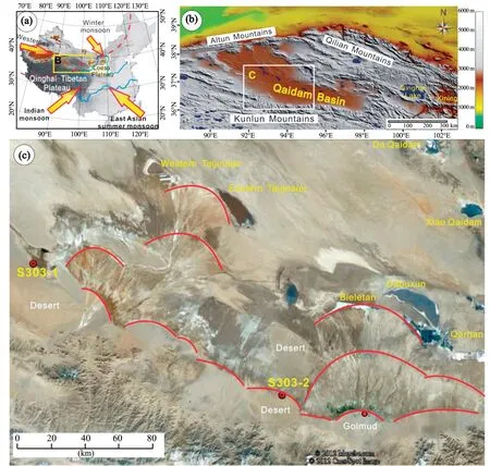
Figure 1 Location of sampling sections and geomorphology of the Qaidam Basin.The red arc lines in (c) show the margins of the alluvial fans
3 Sections and samples
In order to establish the chronology of the paleodunes in the middle and southwestern QB,The natural outcrops were chosen for study (Figure 1c and Figure 2).
The S303-1 section is close to the Eastern Taijinaier River and 85 km away from the Western Taijinaier Salt Lake,and has an elevation of 2,882 m a.s.l.(Figure 1c).This paleodune,stabilized by somePhragmites australison the top,is 6 m high.At depths of 0-0.6 m and 1.5-1.8 m are two layers of vegetation residues.A few layers of salt occur at a depth of about 3 m,which might be caused by leaching and illuviation of the salt mineral in the sand.OSL samples were taken from depths of 1,2 and 4 m.A pit was dug beside the dune to investigate underground stratigraphy,and a salt layer of 3-5 cm was found at a depth of 0.4 m.Another OSL sample was taken from the fluvial/beach sand layer beneath the salt layer at a depth of 0.6 m (Figure 2a).
The S303-2 section,with an elevation of 2,780 m a.s.l.,is 50 km away from the Bieletan Salt Lakes to the north,170 km from the S303-1 section to the west and 60 km to Golmud City to the east (Figure 1c).Hundreds of paleodunes(10-20 m high) are located in this region.OSL samples were taken at depths of 3,7,11 m from a paleodune about 20 m high.This paleodune is stabilized byNitraria tangutorum,Tamarix ramosissimaand vegetation residues of about 1 m thick on the top,which shows that the vegetation is well developed (Figure 2b).Another OSL sample was taken from the lower part of a nearby paleodune,which can offer an earlier starting age of these dunes.However,it was difficult to find the base of these dunes,so the real starting age was not possible to be dated in the current study.
All luminescence samples were collected by hammering steel tubes (about 20 cm long cylinder with a diameter of 5 cm) into freshly cleaned vertical sections.The tubes were then covered with aluminum foil,sealed with opaque tape and wrapped using black plastic bag to avoid light exposure.Eight OSL samples were taken from these two sections.

Figure 2 Sections,samples and OSL ages
4 OSL dating and results
4.1 OSL sample preparation and measurement
In the laboratory,possible light-exposed material at each end of the tube (about 3-4 cm) was scraped away,and the unexposed middle part was used to extract quartz for equivalent dose (De) determination.The samples were treated first with 10% HCl and 30% H2O2to remove carbonates and organics,respectively.The grain size fraction of 38-63 μm was extracted by wet sieving,and then etched by 35%H2SiF6for about two weeks to remove feldspars (Laiet al.,2007a;Roberts,2007;Lai,2010).The resulting quartz grains were washed with 10% HCl to remove fluoride precipitates,and quartz purity was checked by infrared (830 nm)stimulation to monitor the presence of feldspar.Any samples with obvious infrared stimulated luminescence (IRSL) signals were retreated with H2SiF6to avoid Deunderestimation(Lai and Brückner,2008).The quartz grains were then mounted on the center part (approximately 0.5 cm diameter)of stainless steel discs (1 cm diameter) using silicone oil.
OSL measurements were made using an automated Risø TL/OSL-DA-20 reader equipped with blue diodes(λ=470±20 nm) and IR laser diodes (λ=830 nm).The luminescence was stimulated by blue LEDs at 130 °C for 40 s,and detected using a 7.5-mm thick U-340 filter (detection window 275-390 nm) in front of the photomultiplier tube.Ninety percent diode power was used.Irradiations were carried out using a90Sr/90Y beta source built into the Risø reader.Preheat was at 260 °C for 10 s for natural and regenerative doses,and cut-heat was at 220 °C for 10 s for test doses.Signals of the first 0.64 s stimulation were integrated for growth curve construction after background subtraction(last 10 seconds).The concentrations of U,Th and K were measured by neutron activation analysis.For the 38-63 μm grains,the alpha efficiency value was taken as 0.035±0.003(Laiet al.,2008).The cosmic-ray dose rate was estimated for each sample as a function of depth,altitude and geomagnetic latitude (Prescott and Hutton,1994).The dose rates are shown in Table 1.
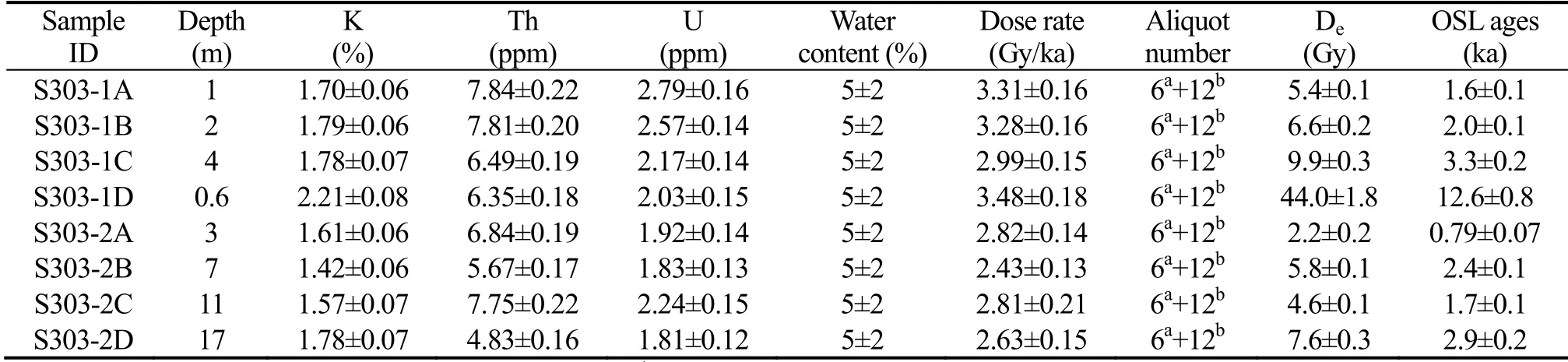
Table 1 Dose rate and OSL ages of the samples
4.2 Equivalent dose determination
Validity of the SAR protocol was tested with a ′dose recovery test′ (Murray and Wintle,2003).This test was conducted on sample S303-2B,and six aliquots of this sample were tested.The given laboratory dose was 5 Gy (approximately equal to its natural De),and the measured Dewas 4.8±0.2 Gy.Thus,the ratios of the measured to the given dose was 0.960±0.040,suggesting that the SAR protocol is suitable for Dedetermination.
In the current study,the SAR protocol (Murray and Wintle,2000) and the Standard Growth Curve (SGC) methods(Roberts and Duller,2004;Lai,2006;Laiet al.,2007b) were employed for Dedetermination.Availability of the SGC method to determine the Deof aeolian samples from the eastern QB has been proved by our former study (Yu and Lai,2012).In the current study,Deresults determined by SGC are well in agreement with those by the SAR protocol within 10% (the two blue lines) for all the samples (Figure 3),suggesting that SGC could be used for Dedetermination.For each of the samples,the final Deis the mean of all SAR Des and SGC Des.
Figures 4a and 4b show growth curve and decay curves of sample S303-2B,respectively,and the decay curves show that the OSL signal was mainly contributed by the fast component.Recuperation was calculated by comparing the sensitivity-corrected OSL signals of 0 Gy to the sensitivity-corrected natural signals.The recuperations of aeolian sediments from the QB were usually <3% (Yu and Lai,2012).The ages of samples in this study are all young,accordingly the standardized nature OSL signal (Ln/TD) is lower,consequently the recuperations ((L0/TD)/(Ln/TD))are relative higher;while for the older sample S303-1D,its standardized nature OSL signal (Ln/TD) is higher,so its recuperation is only 3.5%.However,the recuperations are all lower than 8%,which will not produce a significant influence on the results.The ′recycling ratio′ was introduced to check for sensitivity change correction (Murray and Wintle,2000).For most aliquots,the recycling ratios fall into the acceptance range of 0.9-1.1.Figure 4c shows the distribution of Des,and the normal distribution demonstrates that bleaching among different aliquots was uniform.
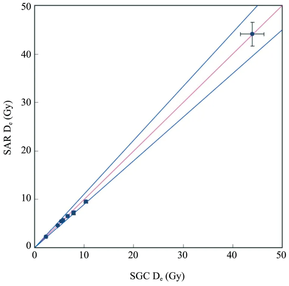
Figure 3 Comparison between SGC De and SAR De
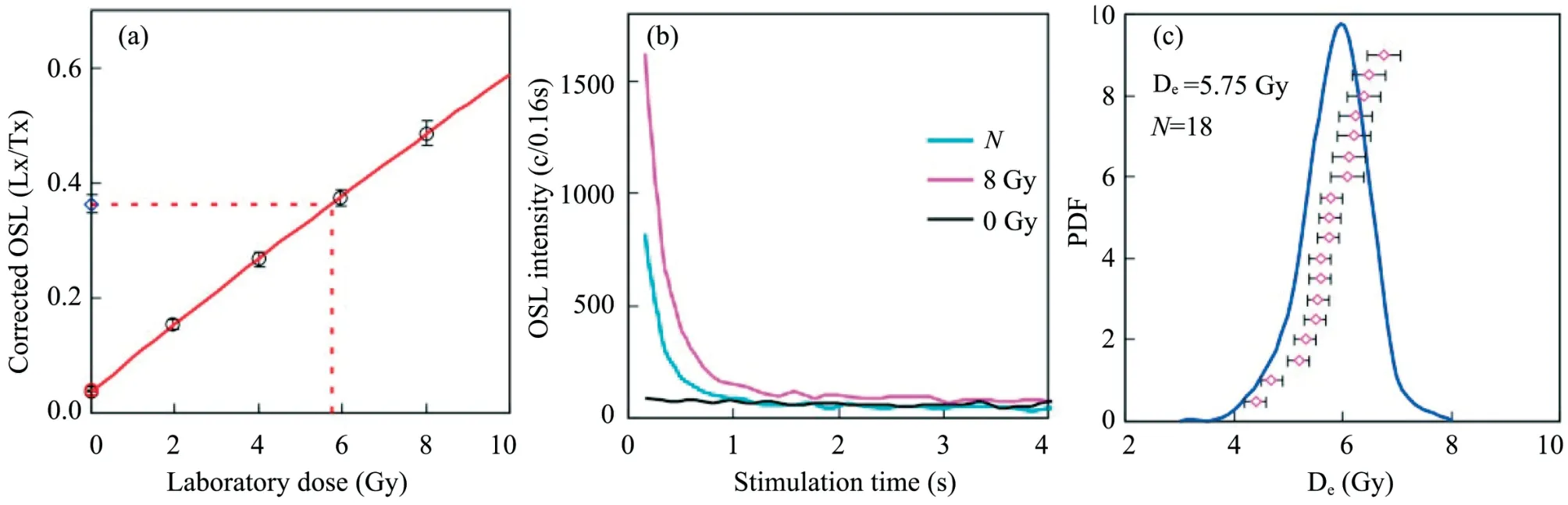
Figure 4 Growth curve (a),decay curves (b) and De distribution (c) of S303-2B
4.3 OSL dating results
OSL dating results are listed in Table 1,and are also shown in Figure 2.Dating results show that the ages are distributed between 3.3±0.2 ka and 0.79±0.07 ka.Paleodunes in the S303-1 section formed during 3.3-1.6 ka,and the paleodunes in the S303-2 section accumulated during 2.9-0.79 ka.
All OSL ages follow the stratigraphic order,except the age of sample S303-2B.The OSL ages present the time since the sediments were buried,so the special depositional processes the paleodunes experienced,especially the processes of ′partly erosion and redeposition′,create a disorder for OSL ages from different parts of the dunes.Additionally,the topographic relief in the deserts influences the connection between depth and ages.It is easy to understand that the age from the upper part on the windward slope is older than the age from the lower part on the leeward slope.Consequently,the disorder of OSL ages in the S303-2 section might not be caused by dating,but display special depositional processes.Sample S303-1D of fluvial sediment produces an age of 12.6±0.8 ka,whose geomorphological implication will be discussed in the next section.
5 Discussion
5.1 Onset ages of the paleodunes
According to the OSL ages,paleodunes in the S303-1 and S303-2 sections accumulated before 3.3±0.2 ka and 2.9±0.2 ka,respectively,however,it was difficult to reach the base of these paleodunes,so the ages of the base could not be directly dated.Taking into account that the depth of the lower samples is close to the basin floor,they could display the onset ages of these dunes to some extent.Deposition of the dunes is usually discontinuous,however,age-depth models (Figure 5) show that the depositional rates are general stable in these two sections (the age of sample S303-2 is excluded) and paleodunes in the S303-1 and S303-2 sites occurred at ca.4 ka and 3 ka,respectively.
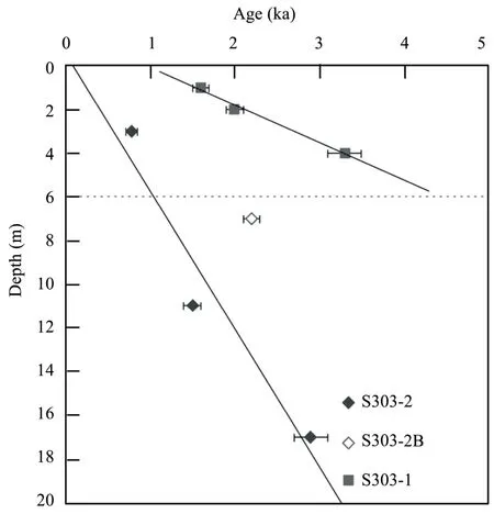
Figure 5 Age-depth models of the sections.The empty diamond point was treated as an outlier and was not included in the age model fitting
Consequently,paleodunes in the middle and southwestern QB possibly accumulated during the late Holocene.The age of fluvial sediments beneath the salt layer underlying the paleodune in the S303-1 section is 12.6±0.8 ka(sample S303-1D),during the late deglaciation.This transition of ′fluvial sand-salt-aeolian sand′ demonstrates a drying trend.The age of the fluvial sand also restrict paleodunes formation to after 12.6±0.8 ka,but not during or before LGM.
Yu and Lai (2012) reported 28 OSL ages from aeolian sediments in the eastern QB,and showed that these aeolian sediments were formed since 12.4 ka.The phenomenon that most aeolian sediments on the QTP accumulated after deglaciation was also found in the Qinghai Lake Basin(Liuet al.,2011,2012;Luet al.,2011),in the northern QB(Owenet al.,2006),on the terraces in the Kunlun Mountains to the south of the QB (Owenet al.,2006;Chenet al.,2011),and the Yalung Zangbo River valley in Tibet (Sunet al.,2007).The reason might be the possibility that aeolian sediments accumulated before deglaciation had been eroded by glacial movement during LGM and/or the alluvial processes during deglaciation,and only aeolian sediments formed after deglaciation could be preserved (Sunet al.,2007).The paleodunes in these two sites that accumulated after 12.6 ka support this mechanism,because these two sites are close to rivers and alluvial fans originating from the Kunlun Mountains (Figure 1c),and the possible intensive fluvial and alluvial processes during deglaciation might cause severe erosion to aeolian sediments formed before that.
In the current study area,the absence of aeolian sediments formed during the early-to mid-Holocene might be due to the following factors.(1) Lakes in the QB expanded under humid conditions during the early-to mid-Holocene,e.g.,lake level of the Xiao Qaidam Lake was about 10 m higher during 11-3 ka than today (Sunet al.,2010),so both increased vegetation and decreased sand source (lacustrine and beach sediments) around the lakes prevented formation of the dunes.(2) Aeolian sediment might have existed,because there were still enough dust and sand supply,and aeolian sediments could form in the more humid eastern QB during the early-to mid-Holocene (Yu and Lai,2012),however,they were eroded by fluvial and alluvial processes during the relative warm and humid periods.(3) The original aeolian sediments reactivated during the late Holocene,and the OSL ages could only represent the last accumulation processes of the sediments.
5.2 Relationship between dune evolution and climatic change
5.2.1 Dune formation during the late Holocene
Although dune mobility is proportion to wind velocity(Lancaster,1998) and related to sand supply (Cohenet al.,2010),generally speaking,the formation of sand seas is a response to arid climates,with the occurrence of sandy layers in sedimentary sequences from both the desert (Zhuet al.,1980) and the desert-loess margin (Liu,1985),which are commonly used as a proxy for changes in aridity (Yanget al.,2011).In the northeastern QTP,alternate deposition of aeolian sand and loess was most likely related to variation between high and low effective moisture,although changing wind strength may also have played a role (Luet al.,2011).Consequently,dunes accumulation in the middle and southwestern QB might be also caused by arid climate.
The absence of loess deposits in some regions,together with an increase of depositional rate and mean grain size of the loess,demonstrates a drying trend of the climate in the eastern QB during the late Holocene (Yu and Lai,2012).One of the most important salifying stages was the late Pleistocene to Holocene,with sediments mainly composed of halite and gypsum with little clastic sediments,demonstrating a hyper arid climate during the late Holocene(Huanget al.,1981).Lacustrine sediments of Chaka Salt Lake were mainly composed of clastic sediments from deglaciation to 5.3 ka,after that the lake shrank and salinized,and the sediments were replaced by evaporites (Liuet al.,2008).The records of pollen assemblages (Shenet al.,2005),δ18O of the Ostracoda (Listeret al.,1991;Liuet al.,2007),and redness (Jiet al.,2005) from Qinghai Lake demonstrate that the late Holocene (ca.4-0 ka) was the most arid period during the whole Holocene.Moreover,reviews of the lakes evolution on the QTP (Zhaoet al.,2009;and references therein) and stalagmite records of Dongge Cave (Wanget al.,2005) show that the climate was arid in the regions controlled by the Asian summer monsoon in the late Holocene.
Consequently,dunes accumulation in the middle and southwestern QB was the response to a hyper-arid climate in the late Holocene.Synchronously,lake shrinkage increased lacustrine sediment exposure,which was the aeolian dust source.
5.2.2 Stabilization of the dunes
The paleodunes in these two sites were stabilized by 0.6-1.0 m thick vegetation residues.The vegetation residue layers in the upper and central parts of the S303-1 section were formed at ca.1.6-0 ka and 1.9-1.7 ka,and that of the S303-2 section was formed at ca.0.5-0 ka,according to the depositional rates in Figure 5.
The longest tree-ring chronology (3,500 years) in China was derived from the eastern QB (Shaoet al.,2007),providing important records for climatic changes during the late Holocene.Reconstructed precipitation records show that most precipitation during the past 1,437 years occurred at 0.47-0 ka in the eastern QB (Shaoet al.,2006).The relative warm and humid periods during 0.5-0 ka were also recorded in other tree-ring records in this region (Shaoet al.,2005,2006).Pollen records from the Dunde Ice Core demonstrate that humidity increased at 0.5-0 ka (Liuet al.,1998).The thickness of varves from Sugan Lake,northern QB,increased at 0.5-0.3 ka (Zhou,2007).All these records demonstrate that the climate during the Little Ice Age (LIA,0.7-0.1 ka) was relative humid.
During the Medieval Warm Period (MWP,1.1-0.7 ka),the tree-ring index increase only occurred at 1.1-1.0 ka in the eastern QB (Kanget al.,1997;Liuet al.,2009).The reconstructed precipitation changes based on tree-ring records show that precipitation during the MWP was lower than that of the LIA (Shaoet al.,2006).Varves records from Sugan Lake further prove that the climate during the LIA was cold and humid,while climate during the MWP was warm and arid (Zhou,2007).This might be the reason why stabilization of the dunes occurred during the LIA.
For dunes stabilization at 1.9-1.7 ka,no obvious corresponding humid climate records was found from tree-ring and ice core records,however,glacial advance was found during 1.9-1.5 ka,similar to that of the LIA (Zhenget al.,1990;Wang,1991).Dune stabilization and humidity increase events in the QB happened synchronously with glacial advance events around the QB,demonstrating that short-term effective moisture changes might be mainly controlled by evaporation associated with temperature changes.
Due to limited age control,it is not possible to precisely restrict the time of dune stabilization.The aforementioned ages were inferred based on depositional rates,but dune stabilization was also possible in modern times.Therefore,relevant forcing mechanisms are difficult to discuss without precise14C ages of the vegetation residue,which could display the time of these dune stabilization events.
6 Conclusions
OSL ages of paleodunes from the middle and southwestern QB show no aeolian sand accumulated before 12.6 ka.Accumulation of the paleodunes in these two regions occurred at 4-3 ka due to arid climate in the late Holocene and increased sand source resulted from lake level decrease.The dunes stabilization of the S303-1 section occurred at ca.1.6-0 ka and 1.9-1.7 ka,while that of the S303-2 section occurred at ca.0.5-0 ka.Both periods of 1.9-1.7 ka and 0.5-0 ka could correspond to glacial advance stages in the northeastern QTP.Consequently,dune stabilization might be caused by increased effective moisture due to decreased evaporation during the short-term cold event in an arid condition during the late Holocene.However,the relationship between dunes stabilization and climatic changes are difficult to discuss without further precise ages of dune stabilization.
This study was supported by SKLLQG (SKLLQG1217),China Postdoctoral Science Foundation founded project(2012M521822),and NSFC (41290252).We thank anonymous reviewers for constructive comments,and Dr.WenXia Han for help in the field.
An FY,Ma HZ,Wei HC,Lai ZP,2012.Distinguishing aeolian signature from lacustrine sediments of the Qaidam Basin in northeastern Qinghai-Tibetan Plateau and its palaeoclimatic implications.Aeolian Research,4:17-30.
Bowler JM,Chen KZ,Yuan BY,1987.Systematic variations in loess source areas:Evidence from Qaidam and Qinghai Basins,Western China.In:Liu TS (ed).Aspects of Loess Research.China Ocean Press,Beijing,pp.39-51.
Bowler JM,Huang Q,Chen KZ,Head MJ,Yuan BY,1986.Radiocarbon dating of playa lake hydrologic changes:examples from northwestern China and central Australia.Palaeogeography,Palaeoclimatology,Palaeoecology,54:241-260.
Chen J,Li G,Yang J,Rao W,Balsam W,Sun Y,Ji J,2007.Nd and Sr isotopic characteristics of Chinese deserts:implications for the provenances of Asian dust.Geochimica et Cosmochimica Acta,71:3904-3914.
Chen KZ,Bowler JM,1985.Preliminary study on sedimentary characteristics and evolution of palaeoclimate of Qarhan Salt Lake in Qaidam Basin.Scientia Sinica (Series B),28(11):1218-1231.
Chen KZ,Bowler JM,1986.Late Pleistocene evolution of salt lakes in the Qaidam Basin,Qinghai province,China.Palaeogeography,Palaeoclimatology,Palaeoecology,54:87-104.
Chen YX,Li YK,Zhang Y,Zhang M,Zhang JC,Yi CL,Liu GN,2011.Late Quaternary deposition and incision sequences of the Golmud River and their environmental implications.Quaternary International,236:48-56.
Cohen TJ,Nanson GC,Larsen JR,Jones BG,Price DM,Coleman M,Pietsch TJ,2010.Late Quaternary aeolian and fluvial interactions on the Cooper Creek Fan and the association between linear and source-bordering dunes,Strzelecki Desert,Australia.Quaternary Science Reviews,29:455-471.
Hao YP,Fang XM,Hu SX,Guan DH,Xi XL,1998.The characteristic of climatic fluctuation recorded by soil formation since late Pleistocene in east region of Qaidam Basin.Scientia Geographica Sinica,18:249-254.
Huang Q,Cai BQ,Yu JQ,1981.The14C age and cycle of sedimentation of some saline lakes on the Qinghai-Xizang Plateau.Chinese Science Bulletin,26:66-70.
Ji JF,Shen J,Balsam W,Chen J,Liu LW,Liu XQ,2005.Asian monsoon oscillations in the northeastern Qinghai-Tibet Plateau since the late glacial interpreted from visible reflectance of Qinghai Lake sediments.Earth and Planetary Science Letters,233:61-70.
Kang XC,Graumlich LJ,Sheppard PR,1997.A 1835 a tree-ring chronology and its preliminary analyses in Dulan Region,Qinghai.Chinese Science Bulletin,42(13):1122-1124.
Kapp P,Pelletier JD,Rohrmann A,Heermance R,Russel J,Ding L,2011.Wind erosion in the Qaidam basin,central Asia:Implications for tectonics,paleoclimate,and the source of the Loess Plateau.GSA Today,21(4-5):4-10.
Lai ZP,Brückner H,2008.Effects of feldspar contamination on equivalent dose and the shape of growth curve for OSL of silt-sized quartz extracted from Chinese loess.Geochronometria,30:49-53.
Lai ZP,Brückner H,Zöller L,Fülling A,2007b.Existence of a common growth curve for silt-sized quartz OSL of loess from different continents.Radiation Measurements,42:1432-1440.
Lai ZP,Wintle AG,2006.Locating the boundary between the Pleistocene and the Holocene in Chinese loess using luminescence.The Holocene,16:893-899.
Lai ZP,Wintle AG,Thomas DSG,2007a.Rates of dust deposition between 50 ka and 20 ka revealed by OSL dating at Yuanbao on the Chinese Loess Plateau.Palaeogeography,Palaeoclimatology,Palaeoecology,248:431-439.
Lai ZP,Zöller L,Fuchs M,Brückner H,2008.Alpha efficiency determination for OSL of quartz extracted from Chinese loess.Radiation Measurements,43:767-770.
Lai ZP,2010.Chronology and the upper dating limit for loess samples from Luochuan section in Chinese Loess Plateau using quartz OSL SAR protocol.Journal of Asian Earth Sciences,37:176-185.
Lancaster N,1998.Development of linear dunes in the southwestern Kalahari,Southern-Africa.Journal of Arid Environments,14:233-244.
Li GJ,Chen J,Ji JF,Yang JD,Conway TM,2009.Natural and anthropogenic sources of East Asian dust.Geology,37:727-730.
Lister G,Kelts K,Chen KZ,Yu JQ,Niessen F,1991.Lake Qinghai,China:closed-basin lake levels and the oxygen isotope record for ostracoda since the latest Pleistocene.Palaeogeography,Palaeoclimatology,Palaeoecology,84:141-162.
Liu KB,Yao ZJ,Tompson LG,1998.A pollen record of Holocene climate changes from the Dunde ice cap,Qinghai-Tibetan Plateau.Geology,26(2):135-138.
Liu TS,1985.Loess and the Environment.China Ocean Press,Beijing.
Liu XJ,Lai ZP,Madsen D,Yu LP,Liu K,Zhang JR,2011.Lake level variations of Qinghai Lake in northeastern Qinghai-Tibetan Plateau since 3.7 ka based on OSL dating.Quaternary International,236:57-64.
Liu XJ,Lai ZP,Yu LP,Sun YJ,Madsen D,2012.Luminescence chronology of aeolian deposits from the Qinghai Lake area in the Northeastern Qinghai-Tibetan Plateau and its palaeoenvironmental implications.Quaternary Geochronology,10:37-43.
Liu XQ,Dong HL,Rech JA,Matsumoto R,Yang B,Wang YB,2008.Evolution of Chaka Salt Lake in NW China in response to climatic change during the Latest Pleistocene-Holocene.Quaternary Science Reviews,27:867-879.
Liu XQ,Shen J,Wang SM,Wang YB,Liu WG,2007.Southwest monsoon changes indicated by oxygen isotope of ostracode shells from sediments in Qinghai Lake since the Late Glacial.Chinese Science Bulletin,52:539-544.
Liu Y,An ZS,Linderholm HW,Chen DL,Song HM,Cai QF,Sun JY,Tian H,2009.Annual temperatures during the last 2485 years in the mid-eastern Tibetan Plateau inferred from tree rings.Science in China(Series D:Earth Sciences),52(3):348-359.
Lu HY,Zhao CF,Mason J,Yi SW,Zhao H,Zhou YL,Ji JF,Swinehart J,Wang CM,2011.Holocene climate changes revealed by Aeolian deposits from the Qinghai Lake area (northeastern Qinghai-Tibetan Plateau)and possible forcing mechanisms.The Holocene,21:297-304.
Murray AS,Wintle AG,2000.Luminescence dating of quartz using an improved single-aliquot regenerative-dose protocol.Radiation Measurement,32:57-73.
Murray AS,Wintle AG,2003.The single aliquot regenerative dose protocol:potential for improvements in reliability.Radiation Measurements,37:377-381.
Niu GM,Qiang MR,Song L,Lang LL,Wang LQ,2010.Change of eastern Asian winter monsoon recorded by aeolian deposits over the past 5000 years at the southeastern margin of Qaidam Basin.Journal of Desert Research,30:1031-1039.
Owen LA,Finkel RC,Ma HZ,Barnard PL,2006.Late Quaternary landscape evolution in the Kunlun Mountains and Qaidam Basin,Northern Tibet:A framework for examining the links between glaciation,lake level changes and alluvial fan formation.Quaternary International,154-155:73-86.
Prescott JR,Hutton JT,1994.Cosmic ray contributions to dose rates for luminescence and ESR dating:large depths and long-term time variations.Radiation Measurements,23:497-500.
Pullen A,Kapp P,McCallister AT,Chang H,Gehrels GE,Garzione CN,Heermance RV,Ding L,2011.Qaidam Basin and northern Tibetan Plateau as dust sources for the Chinese Loess Plateau and paleoclimatic implications.Geology,39:1031-1034.
Qiu XF,Zeng Y,Miao QL,2001.Temporal and spatial distribution,sources and movement paths of the sand storms in China.Acta Geographica Sinica,56(13):316-322.
Roberts HM,2007.Assessing the effectiveness of the double-SAR protocol in isolating a luminescence signal dominated by quartz.Radiation Measurements,42:1627-1636.
Roberts HM,Duller GAT,2004.Standardised growth curves for optical dating of sediment using multiple-grain aliquots.Radiation Measurements,38:241-252.
Shao XM,Huang L,Liu HB,Liang EY,Fang XQ,Wang LL,2005.Reconstruction of precipitation variation from tree rings in recent 1000 years in Delingha,Qinghai.Science in China (Series D:Earth Sciences),48:939-949.
Shao XM,Liang EY,Huang L,Wang LL,2006.A reconstructed precipitation series over the past millennium in the northeastern Qaidam Basin.Advance in Climate Change Research,2(3):122-126.
Shao XM,Wang SZ,Xu Y,Zhu HF,Xu XG,Xiao YM,2007.A 3500-year master tree-ring dating chronology from the northeastern part of the Qaidam Basin.Quaternary Sciences,27(4):477-485.
Shen J,Liu XQ,Wang SM,Matsumoto R,2005.Palaeoclimatic changes in the Qinghai Lake area during the last 18,000 years.Quaternary International,136:131-140.
Sun JM,Li SH,Muhs DR,Li B,2007.Loess sedimentation in Tibet:provenance,processes,and link with Quaternary glaciations.Quaternary Science Reviews,26:2265-2280.
Sun YJ,Lai ZP,Long H,Liu XJ,Fan QS,2010.Quartz OSL dating of archaeological sites in Xiao Qaidam Lake of the NE Qinghai-Tibetan Plateau and its implications for palaeoenvironmental changes.Quaternary Geochronology,5:360-364.
Wang JD,Wang SX,1986.Survey to several Quaternary sections and exploratory to aeolian sediment in Qarhan salt lakes region.In:Qinghai Institute of Salt Lakes,CAS (eds.).Late Cenozoic Geological Environment Evolution in Qaidam Basin,Qinghai.Science Press,Beijing,pp.152-156.
Wang YJ,Cheng H,Edwards RL,He YQ,Kong XG,An ZS,Wu JY,Kelly MJ,Dykoski CA,Li XD,2005.The Holocene Asian Monsoon:links to solar changes and North Atlantic Climate.Science,308:854-857.
Wang ZT,1991.Glacial fluctuations and environment since the Little Ice Age on Central Tianshan Mountains and East Qilianshan Mountains.Acta Geographica Sinica,46(2):160-167.
Xin YL,1995.Windblown sand in the salt lakes in Qaidam Basin.Journal of Desert Research,15:252-255.
Yang XP,Scuderi L,Paillou P,Liu ZT,Li HW,Ren XZ,2011.Quaternary environmental changes in the drylands of China—A critical review.Quaternary Science Reviews,30:3219-3233.
Yu LP,Lai ZP,2012.OSL chronology and palaeoclimatic implications of aeolian sediments in the Qaidam Basin of the northeastern Qinghai-Tibetan Plateau.Palaeogeography,Palaeoclimatology,Palaeoecology,337-338:120-129.
Zeng YF,2006.Environmental changes and cultural transition at Late Holocene in Qaidam Basin.Journal of Arid Land Resources and Environment,20:61-64.
Zeng YN,Feng ZD,Cao GC,2003.Desert formation and evolution in Qaidam Basin since the Last Glacial epoch.Acta Geographica Sinica,58:452-457.
Zeng YN,Ma HZ,Sha ZJ,Li LQ,Li Z,Cao GC,1999.The record of Younger Drays event in eolian sand deposit in Qaidam Basin.Chinese Geographical Science,9:92-95.
Zhao Y,Yu ZC,Chen FH,Ito E,Zhao C,2007.Holocene vegetation and climate history at Hurleg Lake in the Qaidam Basin,northwest China.Review of Palaeobotany and Palynology,145:275-288.
Zhao Y,Yu ZC,Chen FH,Zhang JW,Yang B,2009.Vegetation response to Holocene Climate change in monsoon-influenced region of China.Earth-Science Reviews,97:242-256.
Zheng BX,Jiao KQ,Li SJ,Liu JQ,1990.New progress about chronological studies of Quaternary glaciation in Qinghai-Xizang Plateau.Chinese Science Bulletin,36:482-486.
Zhong DC,1986.Preliminary study of paleodunes in the Qaidam Basin.In:Qinghai Institute of Salt Lakes,CAS (eds.),Late Cenozoic Geological Environment Evolution in Qaidam Basin,Qinghai.Science Press,Beijing,pp.100-103.
Zhou AF,2007.Varve chronology and Late Holocene environmental changes in Sugan Lake,northern Qaidam Basin.Doctor thesis.Lanzhou University,Lanzhou.
Zhu Z,Wu Z,Liu S,Di X,1980.An Outline of Chinese Deserts.Science Press,Beijing.
 Sciences in Cold and Arid Regions2013年2期
- Sciences in Cold and Arid Regions的其它文章
- Amount and temperature effects responsible for precipitation isotope variation in the southern slope of Himalayas
- Seasonal changes in the relationship between species richness and community biomass in grassland under grazing and exclosure,Horqin Sandy Land,northern China
- Afforestation effects on soil microbial abundance,microbial biomass carbon and enzyme activity in dunes of Horqin Sandy Land,northeastern China
- The effects of extreme rainfall events on carbon release from biological soil crusts covered soil in fixed sand dunes in the Tengger Desert,northern China
- Probabilistic modeling of soil moisture dynamics in a revegetated desert area
- Effects of shrubs and precipitation on spatial-temporal variability of soil temperature in microhabitats induced by desert shrubs