Thermo-hydro-poro-mechanical responses of a reservoir-induced landslide tracked by high-resolution fiber optic sensing nerves
Xio Ye,Hong-Hu Zhu,*,Gng Cheng,b,Hu-Fu Pei,Bin Shi,Lu Shento,Alessnro Psuto
a School of Earth Sciences and Engineering, Nanjing University, Nanjing, 210023, China
b School of Computer Science, North China Institute of Science and Technology (National Safety Training Center of Coal Mines), Beijing,101601, China
c State Key Lab of Coastal and Offshore Engineering, Department of Geotechnical Engineering, Dalian University of Technology, Dalian,116024, China
d National Research Council-Research Institute for Geo-Hydrological Protection (CNR-IRPI), Padova, 35127, Italy
e Department of Information Engineering, University of Padova, Padova, 35131, Italy
Keywords: Reservoir landslide Thermo-hydro-poro-mechanical response Ultra-weak fiber bragg grating (UWFBG) subsurface evolution Engineering geological interface Geotechnical monitoring
ABSTRACT Thermo-poro-mechanical responses along sliding zone/surface have been extensively studied.However,it has not been recognized that the potential contribution of other crucial engineering geological interfaces beyond the slip surface to progressive failure.Here,we aim to investigate the subsurface multiphysics of reservoir landslides under two extreme hydrologic conditions (i.e.wet and dry),particularly within sliding masses.Based on ultra-weak fiber Bragg grating(UWFBG)technology,we employ specialpurpose fiber optic sensing cables that can be implanted into boreholes as“nerves of the Earth”to collect data on soil temperature,water content,pore water pressure,and strain.The Xinpu landslide in the middle reach of the Three Gorges Reservoir Area in China was selected as a case study to establish a paradigm for in situ thermo-hydro-poro-mechanical monitoring.These UWFBG-based sensing cables were vertically buried in a 31 m-deep borehole at the foot of the landslide,with a resolution of 1 m except for the pressure sensor.We reported field measurements covering the period 2021 and 2022 and produced the spatiotemporal profiles throughout the borehole.Results show that wet years are more likely to motivate landslide motions than dry years.The annual thermally active layer of the landslide has a critical depth of roughly 9 m and might move downward in warmer years.The dynamic groundwater table is located at depths of 9-15 m,where the peaked strain undergoes a periodical response of leap and withdrawal to annual hydrometeorological cycles.These interface behaviors may support the interpretation of the contribution of reservoir regulation to slope stability,allowing us to correlate them to local damage events and potential global destabilization.This paper also offers a natural framework for interpreting thermo-hydro-poro-mechanical signatures from creeping reservoir bank slopes,which may form the basis for a landslide monitoring and early warning system.
1.Introduction
The construction and operation of dams inevitably create reservoirs that can affect the stability of slopes distributed along riverbanks (Schuster,1979;Paronuzzi et al.,2013;Chen et al.,2022).Large-scale catastrophic reservoir landslides are a potential threat to local communities and infrastructures.The hazards are mainly related to the large-volume rock and soil debris (i.e.value of over 1 ×10⁶m3) and potential high-speed motion.Moreover,it can be amplified by the occurrence of extreme rainfall events that are showing an increasing frequency in recent years due to climatic changes (Alonso et al.,2016;Jones et al.,2021;Ye et al.,2022).Unfortunately,these geohazard events might not be expected to lessen over time,for instance,the first half of 2022 was the deadliest on record for landslides (Westra et al.,2014;Cendrero et al.,2020;Ozturk et al.,2022;Ma and Yuan,2023).
The Vajont landslide,which occurred on October 9,1963,was an iconic reservoir landslide event that provoked a worldwide sensation and served as a wake-up call for hazard monitoring and mitigation in the reservoir area(Müller,1964;Veveakis et al.,2007;Paronuzzi et al.,2013).For this,a large number of researchers have made significant efforts and contributions to this issue,such as the Qiangjianping landslide in Zigui,China,2003 (Wang et al.,2004),San Juan de Grijalva slide in Mexico,2007 (Alcántara-Ayala and Domínguez-Morales,2008),and Outang landslide in Fengjie,China (Yin et al.,2016).The kinematics of these events are quite different,but they have been widely classified into flow-like earth motion and sliding motion (Hungr et al.,2014).The flow-like rheology is mainly related to the hydrodynamic and rock/soil properties,which is supported by power-law viscoplastic flow theory(Iverson et al.,1997;Cascini et al.,2010;Di Maio et al.,2020;Hu et al.,2020).Instead,for creeping landslides,it is usually focused on the location and evolutionary characteristics of potential sliding surfaces (Veveakis et al.,2007;Ye et al.,2022).The impacts of the cyclic filling and drawdown operation of the reservoir are twofold:triggering a seepage process,and/or inducing a stabilizing load at the submerged slide toe (Costa and Schuster,1988;Iqbal et al.,2017).Slope stability can thus be time-dependently enhanced or worsened.Hydromechanical responses of the sliding surface (i.e.shear zone)to predisposing factors often help in understanding the landslide deformation mechanism (Finnegan et al.,2021).The temperature changes in the shear band can be linked to the confined aquifer and landslide deformation (Veveakis et al.,2007;Seguí and Veveakis,2021),which can be further used to evaluate the stability of deep-seated landslide and predict landslide displacement.Nevertheless,there is still a gap in understanding the thermo-hydro-poro-mechanical behaviors inside sliding masses of an activated slow-moving reservoir landslide.
One of the major challenges in landslide hydrogeology is to identify the location and characterize the multi-physics of crucial underground interfaces that can evolve into a sliding surface(Zhu,2023).Fiber optics have been widely employed to obtain accurate temperature and strain data subjected to external forces or temperature variations (Soga and Luo,2018;Shi et al.,2021;Xu et al.,2022a).However,measuring hydraulically relevant variables is challenging but significant,as water is the main mover of earth surface process (Palmer,2017).More recently,fiber-optic multiphysical sensing has reached a new level in groundwater monitoring,which permits us to infer subsurface hydraulic flow paths by utilizing the thermophysical effects of the material (Selker et al.,2006;Zhang and Xue,2019;Sun et al.,2022;Ye et al.,2022).The feasibility to obtain accurate soil-water content measurements using the active-heated fiber-optic (AHFO) temperature sensing method through laboratory tests is demonstrated (Sayde et al.,2010).Encouragingly,the AHFO technique has successfully applied to filed-scale monitoring of hydrology and heat transport in porous media (Read et al.,2013;Sun et al.,2021).Fiber optics has demonstrated their potential in monitoring subsurface multiphysical behavior at high resolutions (Hasler,2022;Sidder,2022).Nonetheless,there are few reports on field landslide monitoring of thermo-hydro-mechanical responses of sliding masses.Actually,this particular feature is crucial in understanding the seepage processes and stress states that affected the slope stability during the filling-drawdown cycles of the reservoir(Paronuzzi et al.,2013).
In this paper,we present the results of thermo-hydro-poromechanical responses tracked by ultra-weak fiber Bragg grating(UWFBG) array deployed at the toe of the Xinpu landslide,in the middle reach of the Three Gorges Reservoir Area.These specialpurpose UWFBG-based sensing cables,acting as a “fiber optic nerve system(FONS)”of the ground(Ye et al.,2022),were vertically buried in a 31 m-deep borehole near the reservoir shoreline to collect data on soil temperature,water content,pore water pressure,and strain.The field-scale multi-physical measurements almost covering the years 2021-2022 display the spatiotemporal profiles in wet and dry hydrologic extremes.Thermo-hydro-poromechanical representations with an unprecedented level of detail will contribute to providing new insights of other crucial engineering geological interfaces besides the slip surface to infer flow fluid migration and stress relief within the sliding masses.
2.Studied landslide
2.1.Site description
The study area is situated at Xinpu Village,Fengjie County,Chongqing,in the middle reach of the Three Gorges Reservoir Area in China (Fig.1).The Xinpu landslide,almost encompassing the whole village,is located on the right bank of the mainstream of the Yangtze River.The Shengjibao landslide was monitored 15 years ago,which is the predecessor of the current Xinpu landslide(i.e.the lower part of the landslide).In October 2006,the activation of the prior Shengjibao landslide was observed when the Three Gorges Reservoir was impounded to 156 m,resulting in extensive deformation caused by the drawdown of the reservoir water level(RWL)and seasonal rainfall (Jiang et al.,2020).In response,16 on-site surface displacement-monitoring stations were installed over the hillslope in March 2007.Since then,localized accelerateddeformation or even acute collapse occurred almost every year within and beyond the original Shengjibao area,leading to several relocations of the residents.Consequently,the boundary was redefined and renamed as the Xinpu landslide.Regrettably,the possibility of additional resettlements cannot be dismissed,as localized large deformations and devastating failure within the landslide have become increasingly severe in recent years than ever.

Fig.1.Location of the study area:(a)Digital elevation model(DEM)(data from https://srtm.csi.cgiar.org/srtmdata/)map of the Three Gorges Reservoir area,China;and(b)Location of the Xinpu landslide bounded by yellow curve,and the sliding towards nearly north-direction.
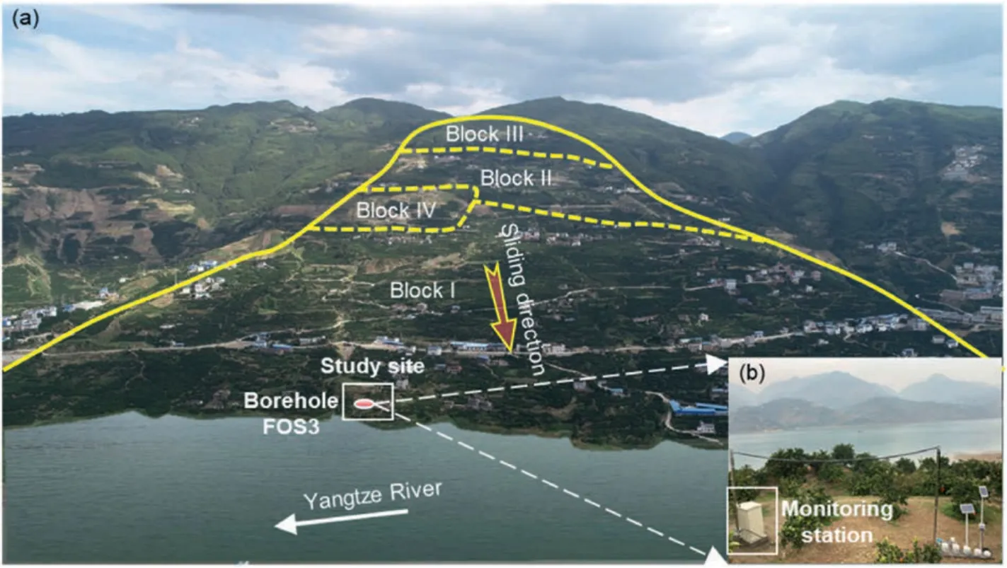
Fig.3.Overview of the Xinpu landslide:(a)Aerial photo of the studied landslide that is zoned four blocks;and(b)Partially enlarged study site and instrumented borehole FOS3,the monitoring box is left on the surface for storing acquisition,communication and control equipment introduced residential electricity supply,rather than a solar panel.
As shown in Figs.2 and 3,the Xinpu landslide is a large-scale complex landslide that ranges from 90 m above sea level (a.s.l.)(toe) to 705 m a.s.l.(crown).It covers an area of 1.94 km2,with a volume of 5.4×10⁷m3and an average slope gradient of about 18°-28°.The main sliding orientation of the slide is almost 347°.The unstable slope has been divided into four blocks in accordance with the landslide style of activity,with the lower part(Blocks I and IV)being the most dominant in terms of landslide deformation.For this,the monitoring campaign has been focused on this zone.The upper and middle parts of the slide are relatively stable (Blocks II and III).Note that the slide toe is perennially submerged under the operating RWL (i.e.145-175 m a.s.l.),making it a typical wading landslide.
Previous drilling exploration data reveal the geological structure of the Xinpu landslide.The slide mass,from top to bottom,mainly consists of gravelly silty clay(i.e.with a gravel content of 20%-40%),gravel with silty clay (i.e.,with a gravel content of 60%-80%),and crushed siltstone(Fig.7).The thicknesses of these layers vary from 3 m to 23.8 m,1.2 m-39.4 m,and 1 m-14 m,respectively.The closer to the slope foot,the thicker the sliding accumulation,reaching 80 m at certain locations.
2.2.Downhole fiber-optic cable configurations
To investigate the multi-physical evolution within the landslide masses,a bunch of specific-purpose fiber optic cables was installed in a 31 m-deep borehole FOS3 at the toe of the Xinpu landslide to measure soil temperature,water content,pore water pressure,and strain,respectively (Figs.2 and 3).Among them,temperature,water content,and strain sensors were encapsulated into cables at 1 m sampling intervals,forming separate sensing arrays (Fig.4).Whereas three piezometric pressure sensors were installed in a 2 m-deep sand filter at depths of 10 m,20 m,and 30 m down the borehole.The interrogator was in situ left in a protective box at the surface near the borehole,and the data were acquired remotely and in real time,typically with a sampling frequency of 1-60 min(Fig.4f and g).The initial reference measurements started on February 11,2021,which was approximately three weeks after backfilling allowing possible effects of compressional consolidation of the filling materials in the borehole to relax and therefore eliminating their effects on the results.
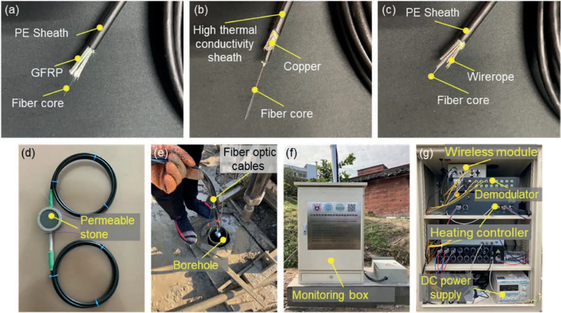
Fig.4.Field installation of UWFBG sensing arrays:(a)Temperature sensing cable;(b)Moisture sensing cable;(c)Strain sensing cable;(d)Pore water pressure cell;(e)Instrumented borehole to be downwards placed and backfilled;(f) Monitoring box at the top of the borehole FOS3;and (g) In situ interrogator.
3.Data and methods
3.1.Principle of UWFBG
Fiber optic Bragg grating (FBG) is one of the most mature fiber optic sensing technology that has been widely employed for geoengineering health monitoring (Kelam et al.,2016,2022).The principle of FBG sensing technology is to create a wavelength selective mirror,by periodically changing the refractive index of the fiber core(i.e.the grating)(Ho et al.,2006).External forces,and the consequent longitudinal strain or temperature variations applied to the grating determine a reproducible shift of the central reflected wavelength of the grating (Soga and Luo,2018).In general,the amount of wavelength shift of the central reflect wavelength encodes simultaneously the overall effects of strain and temperature.
One of the main advantages of this technology is the multiplexing capability,with tens of sensors localized in the same fiber to implement an array of daisy-chained sensors.If each FBG of such an array has a distinct central wavelength,the entire array can be simultaneously interrogated by the so-called wavelength division multiplexing (WDM) technique,which allow addressing each FBG by its own central wavelength.However,it fails to provide a truly continuous description of strain or temperature changes because the number of sensing points(i.e.gratings)along an optical fiber is limited to some tens,depending on the bandwidth requirements of each FBG(Moyo et al.,2005).The limited number of FBGs allocable in a single fiber determines,in turn,a constraint on the spatial resolution,especially if the area to be monitored is wide.Although FBG sensing,in some cases,can provide useful and cost-effective information about global behavior,in some applications it can give only a coarse or partial representation of a specific area of the phenomena.
The UWFBG refers to as a particular FBG technology implemented by gratings with reflectivity of less than 0.01% (-40 dB).Askins et al.(1992) developed a weak-reflection FBG with reflectivity less than 2%and linewidth of about 0.1 nm,and proposed its use as a unit to form a serialized,distributed and addressable sensor array.UWFBG technology has developed over decades to make it possible to apply in various engineering scenarios(Lindner et al.,2014;Yang et al.,2016).In one of the most effective implementations,a large-scale and dense UWFBG sensor array is made up of hundreds or thousands of identical-wavelength FBGs.Given the spectral overlapping of the gratings,the time-division multiplexing (TDM) technique is utilized to enable the simultaneous measurement of numerous gratings along a single fiber,as depicted in Fig.5.This greatly enhances the sensing capacity and offers a spatial resolution of less than 1.0 m that is well-suited to capture hydro-and geo-mechanical behavior of subsurface thin-layer interfaces (Liu et al.,2021;Ye et al.,2022).With the TDM interrogation technique,each grating of the fiber can be addressed from the time difference among the arrival of reflected light passing the entire grating sequence back.Given the vertical deployment of the fiber in the borehole,it allows to probe a specific depth in the borehole where the sensor is located.As specified above,four separated UWFBG arrays were installed,one for each of the measured parameters (i.e.temperature,water content,strain,and pore water pressure).
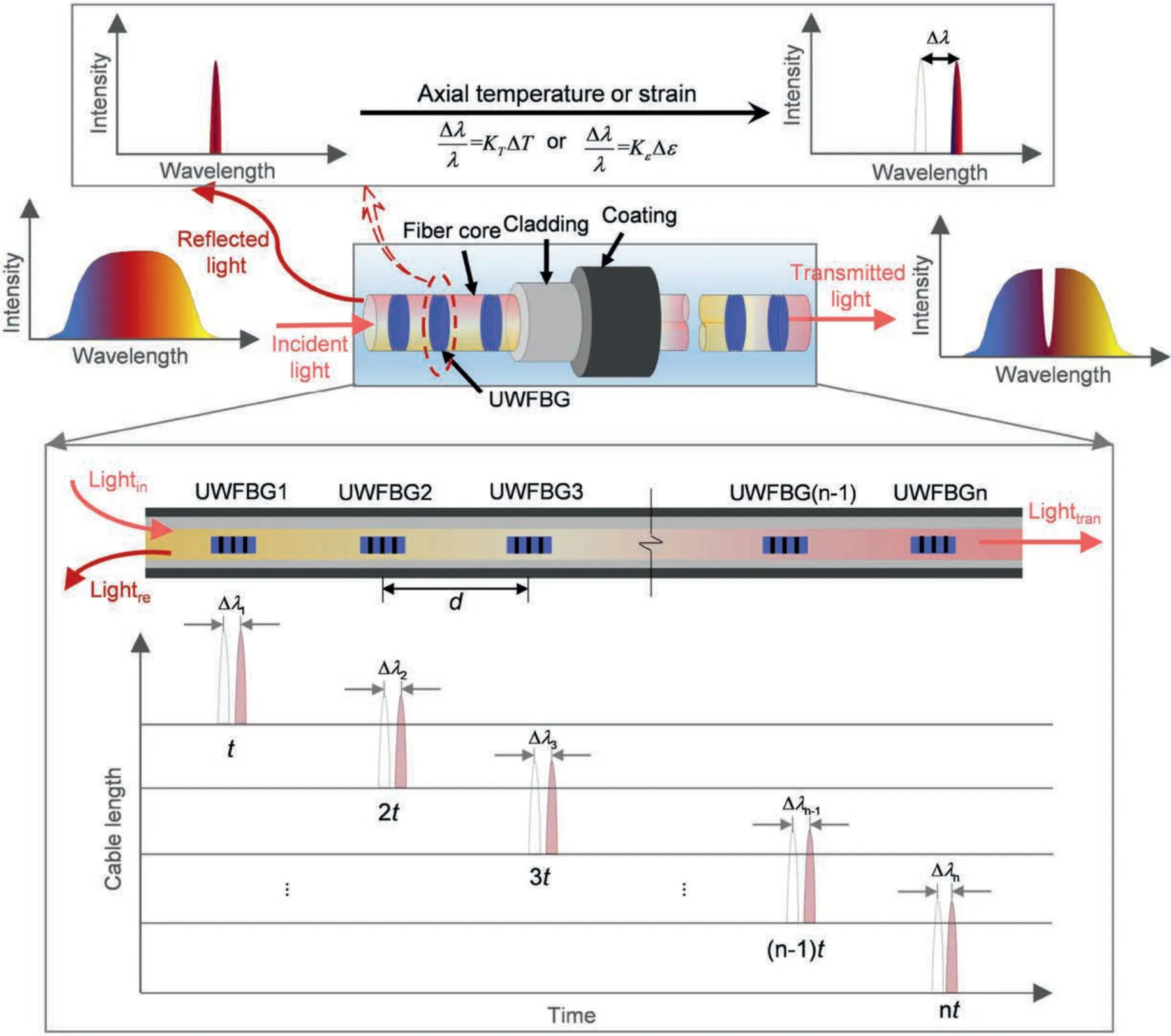
Fig.5.Sensing principle of UWFBG array.
By means of temperature compensation or hollow configuration between the optical fiber and sheath,strain and temperature are readily separated from each other(Zhu et al.,2017).It is noted that both the sheaths of temperature and moisture cable are highly thermally conductive,ensuring highly-sensitive temperature measurement (Fig.4a and b).The water content measurement is performed by an actively-heated UWFBG (AH-UWFBG) moisture sensing cable,which allows for estimation of the water content from the temperature dynamics of the heated cable according to a specific temperature model (Read et al.,2013;Sun et al.,2021;Ye et al.,2022).The strain cable jacket is designed with anchor sections at an interval of 1 m to improve coupling with the soils,and the inclusion of wire ropes enhances its suitability in harsh field conditions (Fig.4c).
3.2.Data preparation
3.2.1.Temperature,water content,pore water pressure,and strain measurements
To obtain accurate measurements,these sensors installed in the borehole need to be calibrated in advance by means of laboratory tests.The temperature or strain coefficient is determined by taking the average of the results of repeated multiple calibrations (see Fig.S1).The calibration methods can be referred to as the previous works (e.g.Liu et al.,2021;Zhang et al.,2021a;Ye et al.,2022).
To calibrate the temperature-related fiber optic cables (i.e.temperature and moisture),the cables were coiled and placed in a thermostat for gradual heating to obtain different levels of wavelength and temperature curves,which were then used to calculate temperature sensitivity coefficients.Further,a remaining section of the moisture sensing cable installed in the field borehole was buried in a laboratory-scale soil column model,and the temperature increments at different water contents were determined as temperature characteristic values (i.e.temperature increments).The heating setup used in the laboratory was consistent with the field setup.Finally,the water content was quantitatively estimated by fitting the relationship between the temperature characteristic value and the volumetric soil water content.
To calibrate the pore pressure,the FBG pore pressure cell was placed inside a sealed water tank and gradually pressurized to determine the wavelength-pressure correlation.Similarly,for strain calibration,a section of the strain sensing cable was subjected to a tensile test while maintaining a constant temperature,and the strain sensitivity coefficient was obtained.According to the principle of FBG sensing,temperature,water content,pore water pressure,and strain were respectively inverted from the measured wavelengths.
3.2.2.Surface displacement
Surface displacements were measured by 41 global navigation satellite system (GNSS) benchmarks and 2 reference points distributed over the slope surface.The reference point is the iron tube placed in a stabilized area.The GNSS observations collected during the same time period(i.e.from January 1,2021,to November 10,2022) as our fiber optic sensing reveal the spatiotemporal pattern of the landslide surface deformation.It provides a valuable comparison for the subsurface monitoring results (Fig.2).
3.2.3.Reservoir water level(RWL)
The TGR was first impounded to~135 m a.s.l.in June 2003,then to~172 m a.s.l.in September 2008,and 175 m a.s.l.in October 2010.Since then,the RWL has been regulated to maintain a flood control level between 145 m a.s.l.and 175 m a.s.l.per year.More specifically,the reservoir level is routinely adjusted to a low level during the rainy season from May to September to mitigate the risk of flooding,and rises back to a high level during other months when precipitation is less.
3.2.4.Meteorological data
Meteorological data used in this study were collected from a weather station installed on the western part of the landslide.Daily records of precipitation and air temperature since 2021 are available,along with other climate-related variables such as wind velocity,atmospheric pressure,and ultraviolet intensity.The station can record these data every 30 min.
4.Results and analyses
In this section,we analyzed the monitoring data (February 11,2021-November 10,2022) to investigate the subsurface thermohydro-poro-mechanical behavior within the sliding masses of the lower Xinpu landslide.Note that the data were missing from June 13-28,2021 due to the anthropogenic interruption of the system power supply.
4.1.Subsurface multi-physical evolution of sliding masses
4.1.1.Soil temperature
The full annual subsurface temperature cycle(ignoring the data gap in gray) since February 11,2021 is reported in Fig.6.The temperature profile,linearly interpolated,shows a depth of around 9 m of the annual thermally active layer,where the soil temperature varies in the range of 16-23°C.Surface temperature measured by the uppermost sensor corresponded well with air temperature records,exhibiting distinct hot and cold seasons.The near-surface temperature varied in the range of 13-38°C (Freifeld et al.,2008).In contrast,in the thermally inactive layer,variations in soil temperature were relatively sluggish,with only a magnitude of about 3°C.Additionally,it seems to be a temperature skew at depths of 9-14 m from early April to mid-October in 2021,but the reason is,at the time being,unknown.
Fig.7 compares the monthly mean temperature distribution in the borehole FOS3 throughout the monitoring period of 2021 and 2022,along with a stratigraphic column illustrating the material composition from the borehole core samples.It is found that the temperature fluctuation in 2022 was less than that in 2021.This might be partly explained by the progressive consolidation of the borehole backfilling which contributes to more robust temperature measurement.This is also the reason that the thermal active layer interface has not been observed with an obvious downward shift in 2022,despite higher near-surface temperatures than those in 2021(Luo et al.,2022).In addition,the ideal linear temperature distribution (i.e.geothermal gradient) has not been found because this borehole is not deep enough (Rybach and Pfister,1994).

Fig.7.Monthly mean subsurface temperature profiles in research borehole FOS3,along with the temperature range indicated in gray: (a) 2021 and (b) 2022.The left column profiles stratigraphic distribution according to the drilling core samples: A -C represent silty clay,crushed siltstone with gravel,and gravelly silty clay,respectively.
4.1.2.Water content
Fig.8a outlines the linearly interpolated water content distribution and its evolution in the considered time-span.We observed an interface of an annual active thermo-hydraulic layer(marked in red dashed dot-dot line),which was also mostly supported by the aforementioned temperature profile.Within these depths,the atmosphere strongly interacted with shallow soils,maintaining a highly active thermo-hydraulic energy conversion,varying from 0.13 m3/m3to 0.32 m3/m3of the water content.More specifically,it was featuring significant rainfall infiltration and soil evaporation during the rainy season (Blight,1997;Sun et al.,2021,2022).In contrast,water was broadly buffered in shallow soils due to weaker evaporation during the non-rainy season.We noted the evident leaps in water content at shallow depths indicating infiltrated rainfall,such as on July 7 and August 26,2021.Moreover,we argued that the water content within depths of 7 m was overestimated during the approximate initial three months of the monitoring campaign.This could be explained by a measurement artifact caused by the borehole construction,which would be naturally removed over time (Hugentobler et al.,2020).
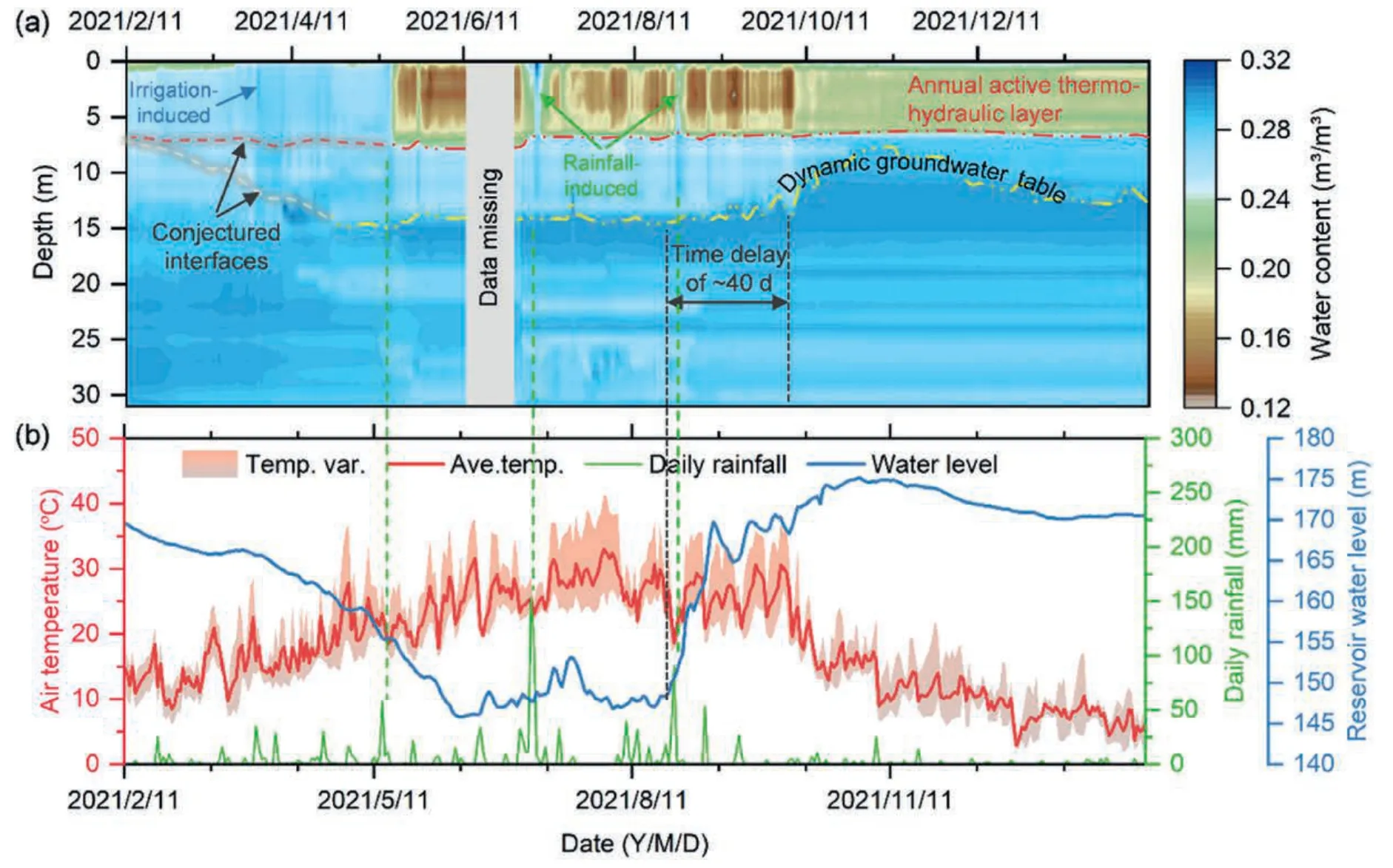
Fig.8.Annual hydraulic responses to the hydrometeorological records: (a) Water content profile,and (b) RWL and their fluctuations.
Strikingly,the evolved water content profile revealed a dynamic groundwater table that fluctuated ranging from 9 m to 15 m(marked in yellow dashed dot-dot line).The groundwater level perfectly matched the RWL regulation,lagging approximately 40 d behind the filling-drawdown of the reservoir water (Prokeˇsová et al.,2013).The groundwater levels inferred from the water content measurements were quite reasonable,since the drilling,for installation of the fiber optic cables in mid-January 2021,had recorded a dive level at a depth of 13 m.The increased water content at the end of March 2021 was confirmed to be caused by agricultural irrigation lasting for several days.These findings,in turn,demonstrate the potential of the UWFBG-based water content evaluation for identifying hydrologic,meteorological,and anthropogenic activities (Froude and Petley,2018;Xu et al.,2022b;Ye et al.,2022).
4.1.3.Pore water pressure
As shown in Fig.9,pore water pressures measured by piezometers installed in the borehole within the landslide toe provided very different pressure values.Overall,changes in pore water pressure measured by the uppermost sensor at a depth of 10 m during the monitoring period show a good temporal correlation with the reservoir level,with slight time lagging.More specifically,the increase-decrease of pore pressure was positively correlated with the fill-drawdown of the RWL.It,however,seems that pore pressure changes did not correlate with fluctuations of reservoir water.In addition,it was not observed that some rainfall events should have caused a rapid increase in pore water pressures.This is possibly related to the fact that they were mostly short-duration and high-intensity rainfalls that almost played a role of surface runoff,and partially attributed to flat terrain and borehole top covered by concrete pier.Changes in pore pressures at deeper levels were much smaller than those at the shallower ones,likely due to the lag of pore pressure transfer in deeper soils,as well as the complexity of the stratum(Schulz et al.,2018).
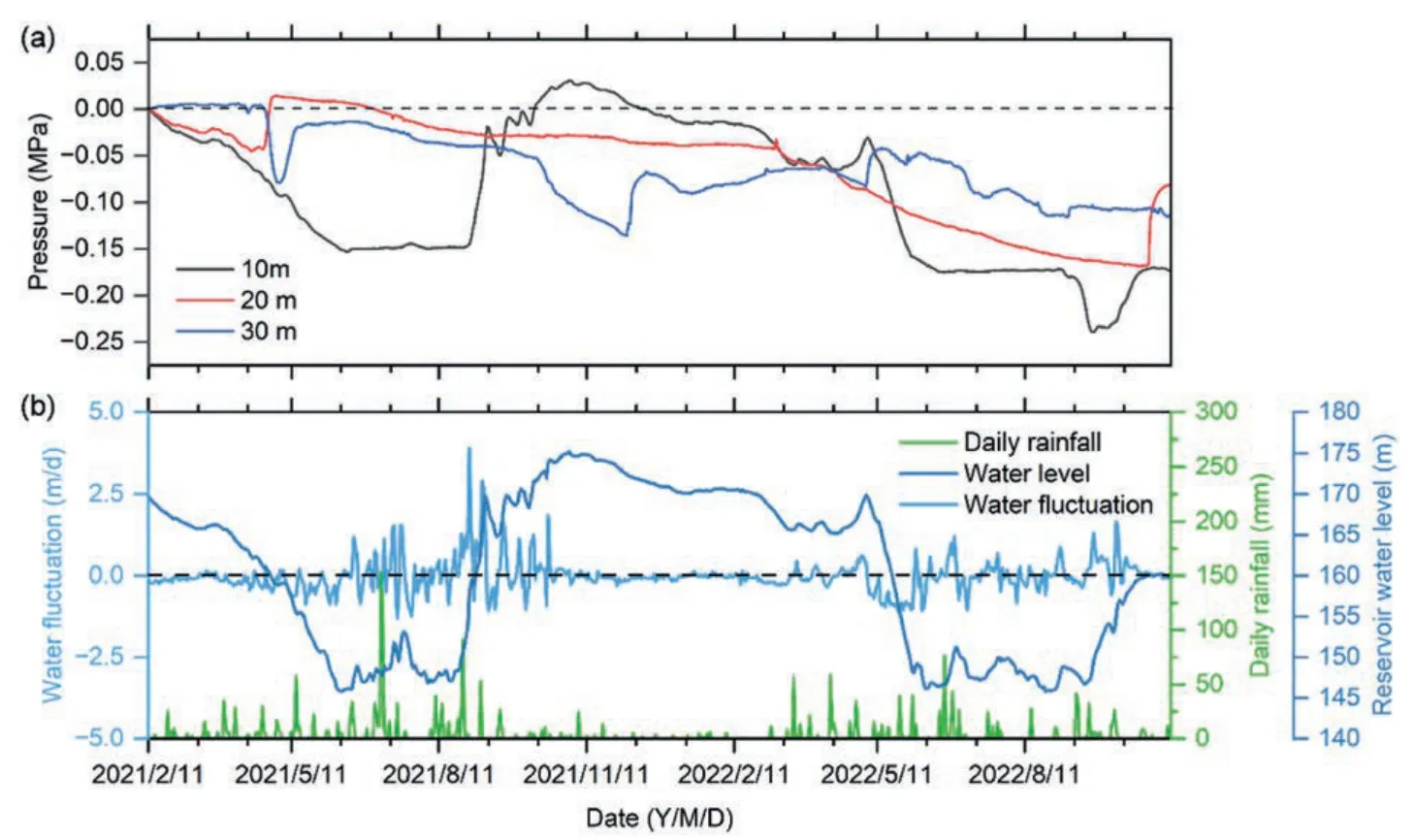
Fig.9.Annual variations in pore water pressures at depths of interest: (a) Pore pressure versus time;and (b) Daily rainfall,RWL,and their fluctuations.
4.1.4.Strain
Fig.10a depicts the annual full-depth strain profile measured since February 11,2021.We observed a prominent peak strain zone at depths of 11-15 m(i.e.close to the conceptualized groundwater table) with a peak strain of 2.1 × 10⁻³that occurred on July 25,lasting for 45 d.It is noted that the strain peak,after the rapid rise in the reservoir level to 170 m a.s.l.on September 10,2021,gradually decreased to 1.05 × 10⁻³within about two weeks and remained largely unchanged,with fluctuations of±1×10⁻⁴.It suggested that the stress concentration in this zone primarily resulted from the agricultural irrigation event at the end of March,as well as the continued drawdown of reservoir water.The presence of smectite clay at a depth of 12 m facilitated the shrinking-swelling of weathered siltstone,which in turn impacted the cohesion and friction of the soil(Baroˇn et al.,2004).The constant rise of reservoir water since late August increased buoyancy at the landslide foot,which contributed to enhancing the landslide stability and exhibited a strain relaxation(Ferrari et al.,2011;Tang et al.,2019).
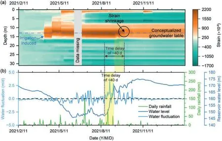
Fig.10.Annual variations in strain: (a) Strain profile;and (b) Records of rainfall and reservoir water levels.
We further compared strain profiles characterized by monthly mean values throughout the monitoring period to clarify the spatial strain distribution and inter-annual evolution(Fig.11a).There was nearly 50% strain reduction at a depth of 13 m from August to December 2021,which was completely different from that within depths of 2.5-7.5 m (i.e.slightly increased compression strain).It suggests that the high-level reservoir water caused reversible deformation at the landslide toe.In contrast,the strain variability in 2022 is much smaller than that in 2021.One possible reason is that the overall landslide deformation in 2022 is much smaller(Fig.2a).Furthermore,the Yangtze River Basin underwent an unprecedented extreme drought in 2022(Ma and Yuan,2023),which led to a delay in the regulation of RWL compared to previous years (e.g.170 m a.s.l.on September 10,2021,compared to 148 m a.s.l.on September 10,2022).This is the reason that the strain contraction was not clearly observed in 2022.As mentioned earlier,such reservoirinduced reversible strain (i.e.implying reversible deformation)may be transformed into irreversible displacements during cyclic reservoir regulation,which macroscopically manifests as an increasingly flattened surface uplift at the landslide toe.

Fig.11.Monthly mean subsurface strain profiles in borehole FOS3 in (a) 2021 and (b) 2022.The annual strain ranges are marked in gray.
4.2.Slope kinematics and its potential controls
According to the data provided by the monitoring system,the recorded surface deformation was much larger in 2021 than that in 2022 (Fig.12a),and this deformation was mostly concentrated in the area below the “anti-slide” piles row,thus confirming the effectiveness of such countermeasure (Zhang et al.,2023).In particular,the landslide kinematic behavior of the upper part of the unstable slope exhibits almost a constant slow deformation trend(e.g.G16,G20,G21),whereas the area below the piles shows a typical step-like deformation pattern in response to the drawdown of reservoir level and/or concentrated rainfall (e.g.G02,G03,G28,G15).It assumes that these stepwise surface displacements were primarily governed by the constant decrease of RWL with a time lag of about 1-1.5 months;a large amount of rainfall further accelerated the deformation.The period of rapid increase of surface displacement in 2021 was prolonged due to a few high-intensity rainfall events,triggering shallow landslides especially in the lower part of the slope (Fan et al.,2020).In contrast,the slight increase of surface displacements in 2022 might be induced by the drawdown of reservoir levels.The entire landslide exhibited an insignificant displacement trend,even within the most active lower part of the landslide (Fig.2a).The landslide movement behavior characterized by surface displacement at the slide toe and borehole strain is consistent (see Figs.10-12).In addition,the extreme drought also forced a change in water level regulation for the 2022 flood season,representing an extended low water period(i.e.150 m a.s.l.) of at least 1 month.Preliminary results suggest that the deformation mechanism of the Xinpu landslide driven by the drawdown of RWL and rainfall is similar to the Shuping landslide,Taping landslide,and Majiagou landslide (Song et al.,2018;Zhang et al.,2021b,2021c).
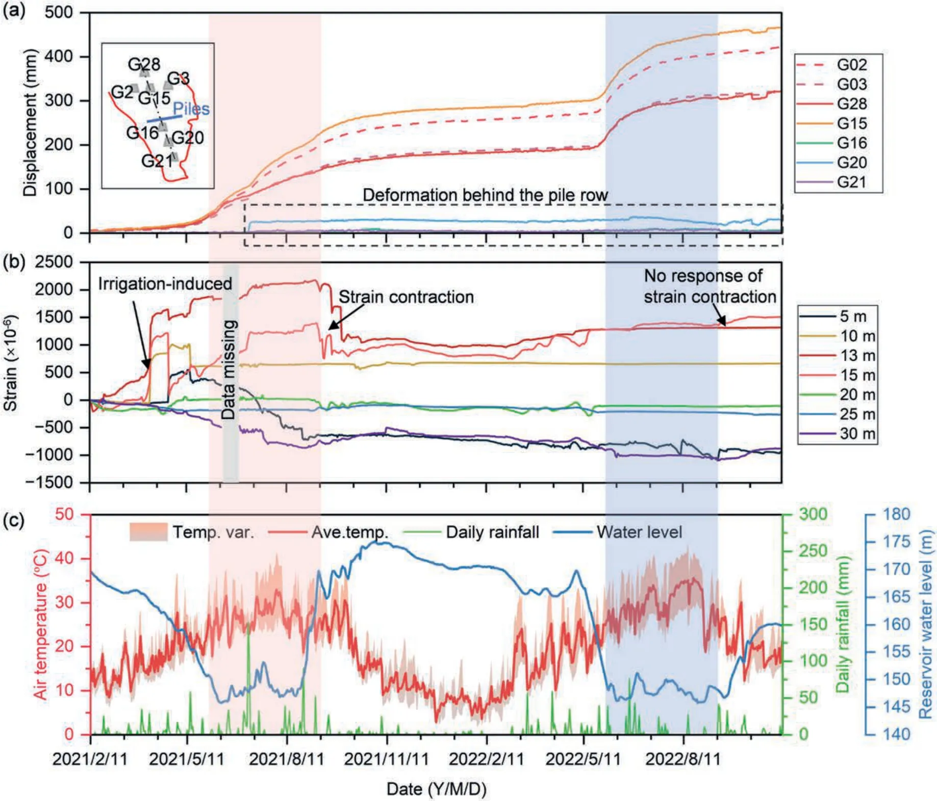
Fig.12.Surface and subsurface kinematics linked to hydrometeorological factors: (a) Lateral surface displacements;(b) Strain time series at depths of interest;and (c) hydrometeorological records.The flood season in 2021 and 2022 are marked by red and blue shaded areas,respectively.
5.Discussion
5.1.Thermo-hydro-poro-mechanical behavior within sliding masses
Temperature,water content,pore water pressure,and strain sensing arrays co-located in a single borehole reveal the effects of annual hydrometeorological cycles on the transient subsurface thermo-hydro-poro-mechanical regime.The annual thermally active layer of the landslide is roughly 9 m thick,which may appropriately shift downward with a warming climate.The water content measurement opens new perspectives for groundwater monitoring,showing an excellent correlation of peak water content evolution with reservoir level regulation and documenting that hydraulic activity within the sliding mass lags behind reservoir levels significantly.The data so far gathered indicate that seasonal pore pressure changes are primarily regulated by reservoir levels rather than rainfall and snowmelt events.The strain sensing arrays allow us to characterize the cumulative deformation reflecting the whole landslide activity,especially at its toe.The data presented confirm that the wet years are more likely to result in substantial deformation (or damage) than dry years (Zscheischler et al.,2018;De Luca et al.,2020).These potential drivers such as rapid drawdown in reservoir levels,intense storms,or extreme temperatures,often act simultaneously(Tichavský et al.,2019;Kafle et al.,2022).The measured strain during these events usually involves irreversible and reversible components that cannot be ignored.The former is permanent damage at crucial engineering geological interfaces within the landslide driven by hydrometeorological factors,whereas the latter may be related to annual reservoir level fluctuations (Hugentobler et al.,2020).
To date,it has been challenging to distinguish the irreversible portion from the deformation associated with progressive rock damage in a relatively short monitoring time series.Nevertheless,the aim of this paper is to provide a natural framework for interpreting the thermo-hydro-poro-mechanical responses of the creeping reservoir slide,with a specific focus on the sliding mass.Here we report a preliminary study based on the monitoring results and analyses spanning almost two years.We anticipate that continued monitoring over multiple annual cycles will allow us to develop an integrated framework for multi-physical monitoring and multi-level early warning of landslide hazards(Ye et al.,2022).
5.2.Implications for understanding landslide kinematics
As illustrated in Fig.13,in a landslide,there are often various engineering geological interfaces that involve migration of threephase media,transformation of state and progressive changes in physical and mechanical properties,such as base-cover interface,local weak surface,interface between fractured rock and clay,diving surface and infiltration front (Zhu,2023).These interfaces sometimes play a controlling role in the process of gestation,development and occurrence of geological hazards.In particular,the first three are often recognized as potential sliding surfaces,where remarkable thermo-hydro-poro-mechanical changes could occur prior to landslide initiation,and macroscopically manifest as large deformations (Hu et al.,2020;Seguí and Veveakis,2021;Scaringi and Loche,2022).The sliding surfaces and other crucial engineering geological interfaces between bedrock and earth surface may provide inspiring information related to landslide evolution processes (Zhu,2023).For instance,due to the morphological changes related to landslide activity,the slip surface near the slide toe is usually quite deep,but it provides an opportunity to investigate multi-physics of the interfaces between the layers of accumulated materials.Here we report inter-annual monitoring results of thermo-hydro-mechanical responses on the dynamic groundwater interface,as one of the crucial engineering geological interfaces,which reveals the evolution of the time-varying and timedelay water content,as well as the strain accumulation and withdrawal.These interface behaviors can support the interpretation of the contribution mechanism of the filling-drawdown of reservoir water on slope stability,allowing us to link them to local failure events and landslide kinematics(Paronuzzi et al.,2013;Tang et al.,2019).
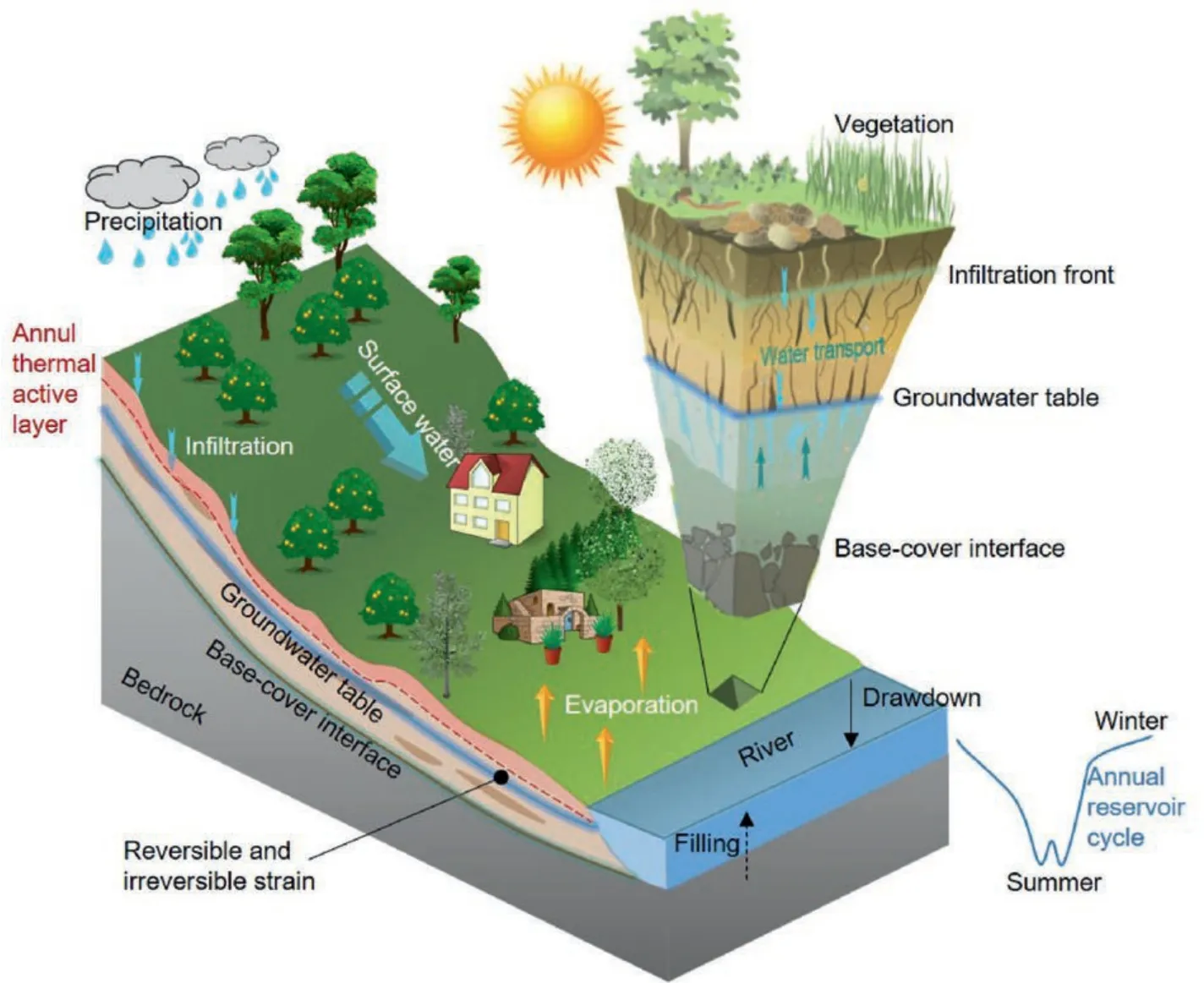
Fig.13.Illustration of crucial engineering geological interfaces in a reservoir landslide subjected to different hydrometeorological conditions.The schematic cross-section conceptually cuts through our borehole location (FOS3),revealing annual thermal active layer,base-cover interface,as well as dynamic groundwater interface that could evolve into a potential sliding surface.
The strain measurements allow some possible mechanisms to be better understood and it seems that the rate of strain accumulation may exacerbate during wet spells after a dry spell(Tichavský et al.,2019).The combined effect of extreme temperatures and rainfall has been correlated to landslide activity due to the shrinking-swelling effects of clay-rich materials,although the entire landslide kinematics tends to be quasi-steady state during dry spells (Lehmann and Or,2012;Bennett et al.,2016).The“forcing”of the hydrologic cycle,that is the increase of frequency of precipitation extremes following extreme high temperatures,is likely to amplify the magnitude of sliding events (Cohen-Waeber et al.,2018;De Luca et al.,2020).We hypothesize that the transition from a quasi-stable slope to a failing landslide is a long-term and continuous process.Therefore,the preliminary findings of this paper will be critically reviewed in future studies based on our continuously updated monitoring dataset.
5.3.Applicability and limitations of UWFBG sensing nerves
Compared to the mature FBG and DFOS technologies,UWFBG allows near real-time acquisition of large amounts of multiphysical data along the fiber optic nerves with high spatial resolution such as temperature,water content,and strain(see Table S1).Specifically,the sensing elements on a single fiber optic nerve can reach over a thousand at an interval of 1 m,which is far less than FBG with comparable measurement accuracy,despite that both of them can collect data remotely and in real time.UWFBG also significantly outperforms DFOS in terms of automatization and integration of monitoring system(Zeni et al.,2015;Shi et al.,2021).Therefore,UWFBG technique is suitable for deep-seated landslides or rockslides,especially for discrimination of critical engineering geological interface (Zhu,2023).
A major limitation so far is that only a few pore water pressure cells can be placed in a borehole with a diameter of 110 mm,given that each pressure cell contains a pie-shaped permeable stones with a diameter of 50 mm.In this aspect,unlike temperature,moisture and strain,we can only acquire depth-specific pore water pressures.Therefore,the determination of the installation depth of the pore pressure cell is challengeable and requires prior knowledge of the formation conditions.In other words,deploying such multi-physical boreholes in critical deformation areas at the lower,middle,and upper parts of the landslide could provide a possibility of understanding the subsurface thermo-hydro-poro-mechanical evolution processes of global large-scale landslides.
6.Conclusions
The present paper describes a multi-physical dataset collected from a novel borehole-based high-resolution fiber optic nerve sensing system using UWFBG technology.The system was installed to continuously record changes in below-ground soil temperature,water content,pore water pressure,and strain with a resolution of 1 m at the toe of the Xinpu landslide in the Three Gorges Reservoir Area,China,to investigate thermo-hydro-poro-mechanical responses of the unstable processes subject to periodical reservoir regulation and seasonal weather events.Here we report a preliminary study that involves monitoring data covering two recent flood periods,and the following conclusions can be drawn:
(1) The annual thermally active layer of the landslide had a critical depth of about 9 m and might appropriately move downward in warmer years.The spatio-temporal evolution of the soil water content revealed a dynamic groundwater table fluctuating from 9 m to 15 m with a time lag of about 40 d with respect of the RWL variations.
(2) Unlike the sluggish water pressure variation in the deep layers,the pore water pressure in the shallow layer at a depth of 10 m showed a close connection with the fillingdrawdown of the RWL.
(3) The peak strain along the borehole profile occurred roughly at a depth of 13 m and experienced a periodical tension and relaxation to annual hydrometeorological cycles.The magnitude of such strain variations was regulated by wet and dry hydrological extremes.As expected,wet years tend to cause much larger strain accumulation,triggering more significant landslide displacements,than dry years.
Declaration of competing interest
The authors declare that they have no known competing financial interests or personal relationships that could have appeared to influence the work reported in this paper.
Acknowledgments
We acknowledge the funding support from the National Science Fund for Distinguished Young Scholars of National Natural Science Foundation of China(Grant No.42225702)and the National Natural Science Foundation of China (Grant No.42077235).Special thanks go to the Institute of Exploration Technology,China Geological Survey,Chengdu,China,for providing geological information of the study area.We also appreciate Xing Zheng,Jia Wang and Bing Wu in Nanjing University for their help in data processing and analyses.The first author particularly thanks Dr.Yu-Zhou Hou in 3rd Construction Co.,Ltd.of China Construction 5th Engineering Bureau for his insightful comments to result analyses.
Appendix A.Supplementary data
Supplementary data to this article can be found online at https://doi.org/10.1016/j.jrmge.2023.04.004.
 Journal of Rock Mechanics and Geotechnical Engineering2024年3期
- Journal of Rock Mechanics and Geotechnical Engineering的其它文章
- Limit load and failure mechanisms of a vertical Hoek-Brown rock slope
- Limit state analysis of rigid retaining structures against seismically induced passive failure in heterogeneous soils
- Bearing capacity of circular footings on multi-layered sand-waste tire shreds reinforced with geogrids
- Experimental investigation on the permeability of gap-graded soil due to horizontal suffusion considering boundary effect
- Damage constitutive model of lunar soil simulant geopolymer under impact loading
- Wetting-drying effect on the strength and microstructure of cementphosphogypsum stabilized soils
