Zokor activity promotes soil water infiltration in the Mu Us sandy land of northern Shaanxi,China
Miao GAN ,Xuchao ZHU ,Xueqin YANG ,Xiaorong WEI ,Qingyin ZHANG ,Tongchuan LI,* ,Ming’an SHAO,*,Meixia MI,Xi YANG and Mingyu CHEN
1State Key Laboratory of Soil Erosion and Dryland Farming on the Loess Plateau,Northwest A&F University,Yangling 712100(China)
2College of Natural Resources and Environment,Northwest A&F University,Yangling 712100(China)
3State Key Laboratory of Soil and Sustainable Agriculture,Institute of Soil Science,Chinese Academy of Sciences,Nanjing 210008(China)
4Henan Institute of Science and Technology,Xinxiang 453003(China)
5College of Urban and Rural Construction,Shanxi Agricultural University,Jinzhong 030801(China)
ABSTRACT Zokors are common subterranean rodents that inhabit agricultural fields,shrublands,and grasslands in the arid and semi-arid regions of China.Zokor burrowing activities can alter soil structure and affect soil hydrological processes;however,there are few studies regarding their effects on soil preferential flow in the Mu Us sandy land.An evaluation of the effects of zokor disturbance on their habitat and soil water is important for understanding the ecological role of zokors in the soil ecosystem of the Mu Us sandy land.A field dye-tracing experiment was conducted in the Gechougou watershed on the southeastern edge of the Mu Us sandy land to investigate the effect of zokor burrowing activity on soil preferential flow characteristics.Our results showed that the density of zokor tunnels was the highest(0.40-0.46 m m-2)under 30%-50%vegetation coverage and that the tunnels were approximately 3 cm from the surface.Both stained area ratio and stained path number were higher at sites with zokors than without zokors.Stained path widths were 10-80 and >80 mm at zokor-harboring sites exhibiting homogeneous flow and heterogeneous finger flow,respectively.In the absence of zokors,homogeneous flow and highly interacted macropore flow were predominant.Soil water content below the zokor tunnels was higher than that above the tunnels.Moderate disturbance of soil structure by zokor activity facilitated soil water infiltration.These results enabled a better understanding of the effect of soil fauna on soil structure and hydrological processes and provided recommendations for ecological construction and renovation in arid and semi-arid regions.
Key Words: field dye-tracing experiment,preferential flow,soil fauna,stained area ratio,stained path number,stained path width,subterranean rodent,surface tortoise crack
INTRODUCTION
The Mu Us sandy land,one of the four major sandy areas in China,covers 42 200 km2and used to be completely devoid of trees and farmland.However,over the past 60 years,the Chinese government has prioritized the ecological construction in this area.Measures have been implemented to control desertification in sandy areas,such as the introduction of mechanical sand barriers(Boet al.,2015) and afforestation (Zenget al.,2009),and achieved good results (Xuet al.,2018).Currently,approximately 93%of the desertified land is covered by vegetation(Nanet al.,2020).However,large-scale afforestation has severely depleted soil water,thereby exacerbating the conflict between soil water supply and demand,causing some of the planted forests to become degraded.D’Odoricoet al.(2013)forecasted increases in the frequency and duration of drought events in the future.In the Mu Us sandy land,soil moisture loss occurs mainly during the growing season due to strong evapotranspiration (Nanet al.,2020).Under the climatic conditions with an uneven seasonal distribution of precipitation,soil water is the most important limiting factor for plant survival and development(Miaoet al.,2015).
Soil preferential flow refers to the movement of water in the soil profile along a preferred path through the soil matrix(Hardieet al.,2011).It is a common form of water transport in soil and is affected by soil texture,fracture,initial water content,fauna,and plant root distribution(Gerke and Kuchenbuch,2007).Preferential flow can accelerate soil nutrient loss and contaminant infiltration,resulting in soil degradation and groundwater contamination(Köhneet al.,2009).However,many ecosystem services benefit from preferential flow (Clothieret al.,2008;Zhanget al.,2016).During periods of low rainfall intensity,finger flow allows the rapid infiltration of water below the root zone(Tanet al.,2017).Studies have shown that approximately 70%-85%of the water movement is associated with preferential flow(Watson and Luxmoore,1986;Wilson and Luxmoore,1988).The presence of preferential flow increases the temporal and spatial variability of soil water movement.Focusing on preferential flow in arid sandy areas is important for optimizing regional water management and promoting sustainable ecosystem development.
Currently,research pertaining to the effect of soil faunal activities on preferential flow generally focuses on earthworms (Maet al.,2021) and ants (Li T Cet al.,2018).However,research on the relationships between larger subterranean rodents and preferential flow is insufficient.Owing to evolution,subterranean rodents have adapted to subterranean tunnel environments and are referred to as“ecosystem engineers”(Reichman and Seabloom,2002).Their activities such as digging tunnels,subsurface foraging,and excretion affect soil texture (Wanget al.,2018),nutrient contents(Mirandaet al.,2019),and water-holding capacity(Wanget al.,2018),as well as plant communities (Wanget al.,2008).Zokor(Myospalax fontanieriisubsp.cansusLyon,1907) is a large subterranean rodent species found in the Mu Us sandy land.Large and small mounds,ridges,and tortoise cracks occur in areas where zokors are active.Zokor tunnel paths are tortuous,featuring many branches,and can reach 66-127 m in length(Fan and Gu,1981).Wanget al.(2008)observed that zokor disturbance resulted in significant changes in soil particle size,which increased the soil water content from 20%to 25%.Currently,vegetation has largely recovered in the Mu Us sandy land,providing sufficient food for the zokor population and possibly resulting in rapid zokor population growth.Zokors feed on plant roots,and their activities disturb soil structure,which to some extent weakens the benefits of afforestation.Studies on preferential flow performed in the Mu Us sandy land have focused on the induction of plant roots(Liet al.,2009),while ignoring the preferential flow resulting from soil surface fractures caused by zokor activity.Therefore,there is a need to evaluate whether the effect of zokor activity on soil water infiltration in the Mu Us sandy land is positive or negative.
Zokor activity affects ecology mainly by altering soil structure(Niuet al.,2019).The dye tracing method is typically used in studies on soil preferential flow(Alaouiet al.,2011;Zhanget al.,2014).This process not only provides visual information regarding the distribution of water in soil but also allows a semi-quantitative analysis of differences in soil water movement and preferential flow characteristics(Meiet al.,2018).The ecological fragility of the Mu Us sandy land is a popular topic in the field of ecological reconstruction.Small-scale afforestation can effectively combat desertification in the region.Intentionally planted shrubs(Amygdalus pedunculataPall.(APE),Salix psammophilaC.Wang&Chang Y.Yang(SPS),etc.)can effectively and rapidly immobilize sand dunes (Xuet al.,2015).In this study,the distribution characteristics of zokor tunnels in different vegetation communities in the Mu Us sandy land were evaluated.Differences in soil staining characteristics were compared between APE sites with and without zokor activity.This study provides a scientific basis for the development of reasonable vegetation restoration measures to promote sustainable ecosystem development in the Mu Us sandy land.
MATERIALS AND METHODS
Study area
The experiment was conducted in the Gechougou watershed on the southeastern edge of the Mu Us sandy land in Shenmu,Shaanxi Province(38°11′-38°53′N,109°21′-110°03′E;Fig.1),China.The watershed has a temperate semi-arid continental monsoon climate.The altitude varies between 1 250 and 1 280 m,average annual temperature is 9.1°C,accumulated temperature ≥10°C is 3 150°C,and the frost-free period ranges from 134 to 153 d(Peiet al.,2021).Average annual precipitation ranges between 250 and 400 mm(mainly concentrated from July to September)and constitutes 60% to 75% of the annual precipitation.The terrain of this watershed is fairly flat,and dunes fill the entire watershed.The soil type is Aridi-Sandic Primosols(CRGCST,2001),with 1.1% clay,3.9% silt,and 95.0%sand.The average bulk density in the 0-10 cm soil layer is 1.64 g cm-3.Currently,this area features little natural vegetation and is dominated by secondary or artificial forests,such asPinus sylvestrisvar.mongolicaLitv.(PSY),SPS,Amorpha fruticosaLinn.(AFR),APE,Artemisia desterorumSpreng.(ADE),Setaria viridis(Linn.) Beauv.(AVI),andStipa bungeanaTrin.(SBU).
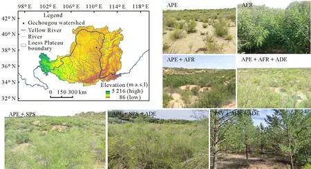
Fig.1 Location of the study area and selected vegetation types in the Gechougou watershed on the southeastern edge of the Mu Us sandy land in Shenmu,Shaanxi Province,China.APE=Amygdalus pedunculata Pall.;AFR=Amorpha fruticosa Linn.;ADE=Artemisia desertorum Spreng.;SPS=Salix psammophila C.Wang&Chang Y.Yang;PSY=Pinus sylvestris var.mongolica Litv.;a.s.l.=above sea level.
Experimental design and sampling
Seven vegetation types(APE,AFR,APE+AFR,APE+AFR+ADE,APE+SPS,APE+SPS+ADE,and PSY+AFR+ADE) in the Gechougou watershed were selected by conducting zokor burrow surveys.A 10 m×10 m quadrat was enclosed using tapes;subsequently,the burrows within the quadrat were counted.Uplifted zokor surface burrows (uplift of 3-5 cm) were used to indicate the zokor viability or community in each vegetation sample.Slope,aspect,and vegetation coverage were measured and recorded.In each sampling quadrat,litter was collected from three sites (1 m× 1 m),where vegetation growth was consistent and distribution was uniform.The litter was placed in an envelope,returned to the laboratory for drying to a constant mass at 75°C for 48 h,and weighed.After the field survey,APE was found to be the most widely distributed in the Mu Us sandy land.The vegetation coverage of APE was low and the vegetation community structure was homogeneous.These results facilitated the evaluation of the impact of zokor activity on soil water infiltration,assuming the influences of vegetation type and community structure on soil water infiltration within the Gechougou watershed could be excluded to a certain extent.Finally,we selected APE sites with zokor activity for field dye-tracing experiment and soil sampling,and a case without zokor was established as a control.
Field dye-tracing experiment
Brilliant blue is highly permeable,non-toxic,highly differentiated from soil color,and inexpensive and has low adsorption.It is currently widely used in field dye-tracing experiments (Laine-Kaulioet al.,2015).A brilliant blue solution with a concentration of 4 g L-1(within the recommended range for good visibility)was used in our dyeing experiment.For APE sites,three 50 cm×50 cm quadrats were enclosed in areas both with and without zokor activity,resulting in six quadrats.The brilliant blue dye was sprayed evenly on the soil surface of each quadrat at a dosage of 40 L.After the dye solution had completely penetrated the soil,it was covered with a plastic film to prevent evaporation.After dyeing for 24 h,a profile was excavated at 10-cm intervals in each dyeing quadrat.Four profiles were excavated for each quadrat,resulting in a total of 24 profiles.The dyeing area was measured using a soil profile ruler,shaded from sunlight,and photographed using a digital camera to record the profile image.While excavating the soil profile,soil samples were collected to a depth of 60 cm at 5-cm intervals and placed into airtight aluminium cylinders to determine soil water content at 105°C using the drying method.Infiltrated soil samples from the dye-tracing experiment were referred to as the infiltration groups in the presence(infiltration-zokor)and absence(infiltration-without zokor)of zokor activity.The natural soil samples adjacent to these groups were referred to as the control group,i.e.,control-zokor and control-without zokor for the control groups with and without zokor activity,respectively.This procedure was repeated thrice for each group.The sampling depth was 60 cm,with 5-cm intervals.Thus,a total of 144 soil samples were obtained.
Image processing and data analysis
The most deeply stained profiles were selected for postanalysis.According to the image processing method(Janssen and Lennartz,2008),the stained images were corrected and cropped using Photoshop,and then the cropped images were converted to a binary format using the Image-J software,where dye-stained pixels(black)were assigned a value of 255,and unstained pixels (white) were assigned a value of 0.Subsequently,MATLAB was used to analyze the binarized image to obtain the morphological parameters of water flow,including stained area ratio(SAR),stained path number(SPN),and stained path width(SPW).Stained area ratio reflects the change law of water flow throughout the soil profile,while SPN and SPW simultaneously reflect the connectivity and branching of preferential flows.Based on the soil texture and actual stained conditions,the SPW of the Mu Us sandy land was classified into three lasses:<10 mm,10-80 mm,and>80 mm.By combining the results of this study with those of other researchers(Weiler and Flühler,2004;Li S Let al.,2018),preferential flows were classified into different types(Table I).
In this study,data were processed using Excel 2016.Oneway analysis of variance (ANOVA) was performed using IBM SPSS Statistics 19 to examine the preferential flow characteristics(SAR and SPN)in the presence and absence of zokors.Relevant figures were created using Origin 2021 and Photoshop CC 2019.
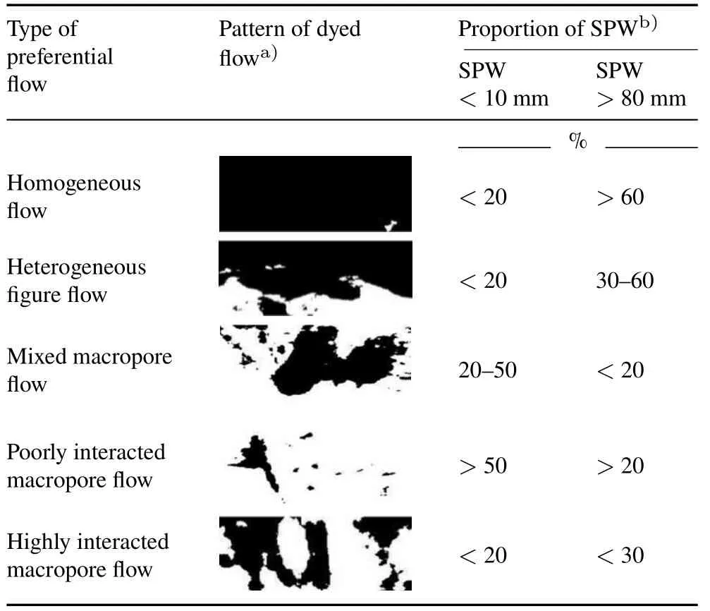
TABLE ICriteria for classification of soil preferential flow(Weiler and Flühler,2004;Li et al.,2018)
RESULTS
Horizontal zokor tunnels under different vegetation types
The results of our field investigation showed that the surface uplifts caused by zokor activity were 10-20 cm in width and that the horizontal tunnels were approximately 3 cm from the surface.The horizontal zokor tunnels were abundant and connected with a tunnel diameter of 7-10 cm(Fig.2).When the vegetation coverage of one site was 30%-50%,the density of zokor tunnels was greater than that of other sites (Table II).At the APE+AFR+ADE sites,the vegetation coverage was 34%and the density of zokor tunnels was as high as 0.46 m m-2.The APE sites,which showed the lowest vegetation coverage(13%),had the lowest aboveground litter and tunnel density.However,at the PSY+AFR+ADE sites,vegetation coverage(66%)and aboveground litter(546 g m-2)were the highest among the seven sampling sites,whereas the zokor tunnel density was only 0.30 m m-2.
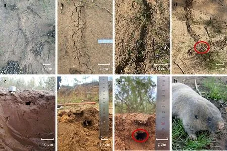
Fig.2 Surface uplifts(a-d)and tunnel profiles(e-g)by zokor activities and a close-up of a zokor(h)in the Gechougou watershed on the southeastern edge of the Mu Us sandy land in Shenmu,Shaanxi Province,China.
Characteristics of preferential flow in zokor tunnels
Stained images obtained from the sandy land in the Gechougou watershed were analyzed to compare the preferential flow in tunnels with and without zokors.The black areas in the images represent the stained areas(Fig.3).Zokor activity resulted in differences in the depth of soil preferential flow.For sites with zokor tunnels,the depth of water infiltration in the soil profile was approximately 30 cm from the surface and the stained paths were more branched.In the absence of zokor,the stained area was evenly distributed and the infiltration depth was shallower.These preferential paths determined the distribution and conduction processes of water and the dye solution in soil.
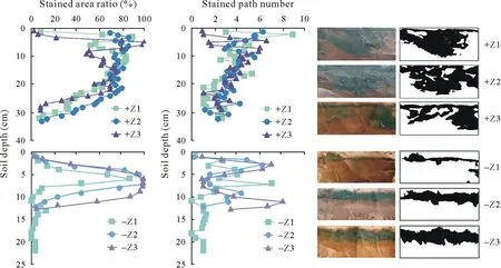
Fig.3 Stained area ratio (SAR),stained path number (SPN),and vertical distribution of water flow in the most deeply stained profiles after the field dye-tracing experiment conducted at Amygdalus pedunculata Pall.sites in the Gechougou watershed on the southeastern edge of the Mu Us sandy land in Shenmu,Shaanxi Province,China.Black areas in the binarized images represent the stained areas.+Z1,+Z2,and+Z3=three sites in the presence of zokors;-Z1,-Z2,and-Z3=three sites in the absence of zokors.
Both SAR and SPN of the soil profiles with zokors were greater than those without zokors(Table III).At the sites with zokors,SAR decreased with increasing depth,whereas at the sites without zokors,SAR first increased and then decreased sharply in the layer below 10 cm,with a mean value of approximately 4%.In the presence of zokors,SPN decreased with increasing depth in the soil layer below 10 cm until it completely disappeared at approximately 35 cm(Fig.3).The SAR and SPN differed significantly among the different soil layers at the same site (Table III).In the presence of zokors,SAR was significantly higher at 5-10 cm(71.55%)than that below 10 cm(53.05%).In the absence of zokors,SAR reached a maximum of 64.86%at 5-10 cm,which was significantly higher than that at 0-5 cm and below 10 cm.At sites with zokors,SPN did not differ significantly among soil layers,whereas at sites without zokors,SPN continued to decrease with depth to 1 (Table III).In general,SAR decreased rapidly from 15 and 5 cm below the soil surface in the presence and absence of zokors,respectively,indicating a clear preferential flow at the sites with zokor tunnels.
The SPW of the preferential flow was primarily 10-80 and>80 mm,while the stained area with an SPW<10 mm constituted only 0.01%-2.78%of the total stained area of the profile(Fig.4).The stained area with an SPW>80 mm constituted the largest proportion of the total stained area.In the 0-10 cm soil layer,the stained area with an SPW of 10-80 mm were 1.37 times higher in the presence of zokors than in the absence of zokors(Table III).Below 10 cm,the stained area with SPW<10 mm,10 mm ≤SPW ≤80 mm,and SPW>80 mm were 13.77,51.18,and 4.20 times higher at sites with zokors than those at sites without zokors,respectively.

TABLE IIDensity distribution of zokor tunnels under different vegetation typesa) in the Gechougou watershed on the southeastern edge of the Mu Us sandy land in Shenmu,Shaanxi Province,China

Fig.4 Proportions of different stained path widths(SPWs)in the most deeply stained profiles after the field dye-tracing experiment conducted at Amygdalus pedunculata Pall.sites in the Gechougou watershed on the southeastern edge of the Mu Us sandy land in Shenmu,Shaanxi Province,China.+Z1,+Z2,and+Z3=three sites in the presence of zokors;-Z1,-Z2,and-Z3=three sites in the absence of zokors.
Combining SPW (Fig.4) and the classification standard of soil preferential flow (Table I),the soil profiles showed clear characteristics of soil preferential flow(Fig.5).Specifically,homogeneous flow and heterogeneous finger flow were abundant in the soil profiles with zokor tunnels.In contrast,in the absence of zokors,more homogeneous flow and highly interacted macropore flow were observed.Further,in the 4-7 cm soil layer,zokor activity did not significantly affect the preferential flow type,which was primarily homogeneous flow.However,the preferential flow type below 12 cm differed significantly.The highly interacted macropore flow occurred in the soil profiles without zokors,whereas in the soil profiles with zokors,the preferential flow of highly interacted macropores was concentrated below 25 cm.Thus,zokor activity could promote homogeneous and heterogeneous finger flows.
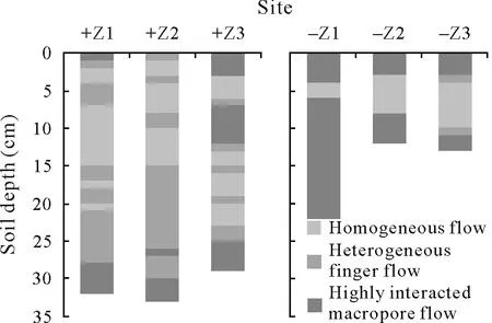
Fig.5 Types of soil preferential flow at different sites in the most deeply stained profiles after the field dye-tracing experiment conducted at Amygdalus pedunculata Pall.sites in the Gechougou watershed on the southeastern edge of the Mu Us sandy land in Shenmu,Shaanxi Province,China.+Z1,+Z2,and+Z3=three sites in the presence of zokors; -Z1, -Z2,and-Z3=three sites in the absence of zokors.
Soil water distribution under zokor activity
Soil water content above zokor tunnels (29.3 g kg-1)was similar to that in the APE sites without zokor(control group) and lower than that below zokor tunnels (37.3 g kg-1)(Fig.6).At the APE sites,the soil water content in the control group increased gradually in the 0-40 cm soil layer,whereas that in the infiltration group firstly increased and then gradually decreased as soil depth increased(Fig.7).Soil water content in the infiltration group tended to be constant(30-50 g kg-1)below 40 cm.Zokor tunnels in the control group did not significantly affect soil water distribution across the soil profile.In the infiltration group,soil water content in the 5-15 cm soil layer with zokor tunnels was lower than that in the absence of zokor tunnels(Fig.7);however,soil water content in the 15-35 cm soil layer increased in the presence of zokor tunnels and was significantly higher than that in the absence of zokors.

TABLE IIIMorphological parametersa)of the dye tracer images in different soil layers in the most deeply stained profiles after the field dye-tracing experiment conducted at Amygdalus pedunculata Pall.sites in the Gechougou watershed on the southeastern edge of the Mu Us sandy land in Shenmu,Shaanxi Province,China
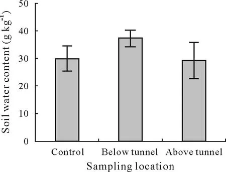
Fig.6 Soil water content above and below zokor tunnels at Amygdalus pedunculata Pall.sites in the Gechougou watershed on the southeastern edge of the Mu Us sandy land in Shenmu,Shaanxi Province,China.Vertical bars indicate standard deviations of the means(n=3).Control=APE sites without zokors.

Fig.7 Vertical distribution of soil water content in the 0-60 cm soil layer in the field dye-tracing experiment conducted at Amygdalus pedunculata Pall.sites in the Gechougou watershed on the southeastern edge of the Mu Us sandy land in Shenmu,Shaanxi Province,China.Vertical bars indicate standard deviations of the means (n=3).Infiltration-zokor and infiltration-without zokor=infiltrated soil samples in the presence and absence of zokor activity,respectively;control-zokor and control-without zokor=natural soil samples in the presence and absence of zokor activity adjacent to the infiltrated soil samples,respectively.
DISCUSSION
Zokor tunnels and vegetation
Vegetation coverage is one of the most intuitive indicators of natural restoration and significantly alters the local environment for soil fauna.Based on the correlation analysis results (data not shown),vegetation coverage indicated a significant positive correlation with tunnel density (R=0.458) and a highly significant positive correlation with litter density(R=0.844).In general,vegetation provides abundant food and a suitable habitat for soil fauna,thus promoting their dependence(Shi and Yu,2010).Zokors live in underground burrows throughout the year and feed on the underground tissues of plant.Digging and feeding activities of zokors adversely affect the connection between the plant roots and deep soil,and thus the taproots.To compensate for the damage to roots,plants increase their height and leaf area to improve their photosynthetic efficiency(Zhang and Li,2015).Further,higher vegetation coverage mitigates the direct impact of precipitation on surface soil(Zhanget al.,2011),thereby reducing the permeability of precipitation and soil compaction,which is important for zokor habitats(Hamza and Anderson,2005).Although damaging the vegetation,zokor activity does have a positive impact on the ecosystem.Zokor disturbance significantly reduces soil temperature and increases soil moisture(Niuet al.,2019),which benefits plant colonization(Fan and Gu,1981)and sustains vegetation coverage (Chenet al.,2007).Furthermore,Liuet al.(2011) reported that a moderate amount of zokor tunnel space did not significantly affect vegetation coverage and in fact increased vegetation species diversity and aboveground biomass.Indeed,plant species diversity index is positively correlated with the intensity of zokor disturbance(Chuet al.,2020)and vegetation productivity typically declines only when the zokor population densities exceed the carrying capacity of the regional environment(Pechet al.,2007).In this study,the vegetation coverage was generally favorable.Therefore,we hypothesize that the current zokor population density in the Gechougou watershed is not excessive and that the zokor burrowing for seed storage and offspring reproduction is beneficial to the ecological recovery of the area.
Zokor tunnel density varies depending on the vegetation type.Cuiet al.(2007)suggest that the presence of zokors is the result of their long-term adaptation to artificial forest ecosystems,which is determined by their own characteristics as well as those of the vegetation community structure and soil type.Weeds are the mainstay of zokor diet,while zokors are forced to feed on tree roots only when food is scarce(Hanet al.,2005).Zokors are generally not interested in most shrub roots,because they cannot easily chew through the roots of intertwined trees,dig tunnels,and search for a few grass roots.Subterranean rodents prefer vast and relatively flat areas for their activities (Li and Wang,2015).Vleck(1979)observed that the energy consumed by zokors while digging a unit length was 360-3 400 times the energy consumed by ground rats of the same weight while walking the same unit distance.Therefore,zokors prefer locations with relatively loose soil for daily activities to avoid excess energy consumption.Tunnels with the highest zokor population density were indicated at the sites with 30%-50%vegetation coverage(Table II).The corresponding vegetation types were mainly APE,SPS,and ADE.Low vegetation communities are ideal habitats for zokors(Shi and Yu,2010).Trees(PSY)and shrubs (APE and SPS) were extensively used in the sand control project in the Gechougou watershed.This has deprived zokors of the herbaceous vegetation and young trees,thus destroying their optimum living environment.Consequently,zokor population density decreased and stabilized at a lower level(Cuiet al.,2007).At the PSY+AFR+ADE sites,although vegetation cover was high,zokor tunnel density was low.Firstly,AFR is a highly resistant species(Hanet al.,2009),and the zokor tunnel density in a single vegetation type is only 0.26 m m-2(Table II).Secondly,although zokors prefer to feed on the roots and seedlings of PSY (Hanet al.,2009),the resistance and tolerance of the species increases with age (Hanet al.,2005).The PSY in the study area features a stand age of approximately 20 years (Peiet al.,2021).Thirdly,PSY is an arbor,and abiotic factors such as light,soil moisture,and temperature in the PSY forests differ significantly from those of shrubs.These differences affect the abundance and distribution of zokors,which consequently changes the extent of their damage to the vegetation(Cuiet al.,2007).Zokor tunnel density was the highest at the APE+AFR+ADE and APE +SPS +ADE sites because zokors prefer to feed on ADE.Therefore,the selection of sand control species to reduce rodent infestation should be comprehensively considered when planning the construction or renovation of artificial forests in the Gechougou watershed.
Zokor tunnels and soil preferential flow
Soil preferential flow typically occurs in silt and clay soils(Zhang and Peng,2015).However,Meiet al.(2018)revealed that sand contributes to the occurrence of preferential flow.In the Gechougou watershed,soil clay content was extremely low and the soil was loose,resulting in a larger soil pore and a higher water infiltration rate.In addition,the subsoil hindered water infiltration by increasing the time required for the dye to fully contact with the surface soil.This resulted in larger SPW values in the shallow soil profile.Both Shawet al.(2000)and Jarviset al.(2007)noted that when the sand content was high,the water exchange between the pores and surrounding soil was more pronounced,which is typically manifested as homogeneous flow or highly interacted macropore flow.In this study,soil sand exceeded 90%,the water flow tunnels were close to each other,and the tunnel widths were similar during the water infiltration process.Therefore,homogeneous flow was predominant at 4-7 cm,where SPW was generally>80 mm (Fig.4).In summary,the homogeneous flow in the 4-7 cm layer of the APE site was mainly affected by sand content rather than zokor activity.There was a consistent distribution of SAR in the stained 4-7 cm profile for both sampling sites in the presence and absence of zokors(Fig.3),which further confirmed our results.
At sites with zokors,soil sand content was positively correlated to the stained area with SPW<10 mm(P <0.05,R=0.376)and 10 ≤SPW ≤80 mm(P <0.01,R=0.295)(Table IV).However,no significant correlation was observed between sand content and morphological parameters of the dye tracer image in the absence of zokors.This suggests that zokors play a more important role in the water infiltration process in sandy soil,most likely because zokors affect soil structure by constructing a tunnel system,which in turn affects the flow path of soil water(Botscheket al.,2002).Surface uplift and tortoise cracks were evident at the sites with zokor activity(Fig.2).The cracks damaged soil integrity and formed connected complex branches on the soil surface,which exhibited strong heterogeneity and anisotropy.A significant amount of water can propagate laterally along the fracture,thus creating preferential flow along the horizontal direction(Tuonget al.,1996).In subsequent irrigation or rainfall events,the cracks caused by zokor activity can serve as a preferential flow path that allows surface water to reach the deeper soil layers rapidly,thus increasing the infiltration rates(Nováket al.,2000;Chenet al.,2021).Moreover,the initial water content significantly affects the morphological characteristics,maximum infiltration depth,and migration rate of soil preferential flow (Hardieet al.,2011).When the initial water content was low,more water flowed from the surface pores to the deeper layers(Merdunet al.,2008),suggesting that sand content and initial water content exert less effects on water infiltration than zokor activity in the Gechougou watershed.

TABLE IVCorrelation coefficients of soil sand content with morphological parametersa) of water flow
Soil water content below zokor tunnels was higher than that above the tunnels.The Mu Us sandy land is a fragile ecosystem with low soil nutrient contents and humidity.In this case,soil water is mainly transported in a vertical direction through infiltration and evapotranspiration(Graysonet al.,1997).Sandy soil has a higher soil connectivity,which significantly reduces soil water retention capacity(Zeleke and Si,2005).Moreover,zokor burrowing alters the original soil structure and increases the content of soil non-capillary pores(Wanget al.,2018),which enables rapid loss of soil gravitational water through structural pores,thus accelerating topsoil loss.Evapotranspiration can consume approximately 60%of the surface soil water(Oki and Kanae,2006).Therefore,soil water content above the tunnel was low.Additionally,the number of water infiltration paths increased owing to zokor activity.This was confirmed by the results of significantly higher SAR,SPN,and SPW at sites with zokors than those at sites without zokors in the soil layer below 10 cm (Table III),likely because zokor tunnels accelerated the downward infiltration of water and cut offthe upward path of soil moisture,thereby preventing water from evaporation(Chenet al.,2021).Suet al.(2020)confirmed that zokor disturbance significantly increased soil water content at 10-40 cm.The current zokor population in the Gechougou watershed is appropriate,and vegetation mortality due to the chewing of roots by zokors has not been reported.Therefore,the impact of zokor burrowing on water infiltration in the Gechougou watershed is positive.
CONCLUSIONS
The effect of zokor activity on soil water infiltration was more pronounced than those of soil sand and initial water contents.Soil water infiltration was deeper,and more branching occurred at sites with zokor tunnels.The soil profile at sites with zokors showed both homogeneous flow and heterogeneous finger flow,whereas at sites without zokors,the preferential flow types were homogeneous flow and highly interacted macropore flow.Zokor activity increased soil water content below the zokor tunnels.Vegetation coverage and tree species were the main factors influencing zokor tunnel density.Zokor population density in the Gechougou watershed did not exceed the regional environmental carrying capacity,and the moderate disturbance of soil structure by zokors facilitated soil water infiltration.With the restoration of artificial vegetation,the impact of soil-dwelling fauna on soil ecology in the Mu Us sandy land should be taken seriously.
ACKNOWLEDGEMENT
This research was supported by the National Natural Science Foundation of China(Nos.41807011 and 41907012),the Chinese Universities Scientific Fund(No.2452022335),and the Open Fund for Key Lab.of Ecological Study of Ningxia University,China(No.LDER2022Z01).
- Pedosphere的其它文章
- Developing the new soil science-Advice for early-career soil scientists
- Biophotoelectrochemistry:An emerging frontier for channeling photoelectric effect into darkness zone of soils and sediments
- Balancing machine learning and artificial intelligence in soil science with human perspective and experience
- Soils in extraterrestrial space:Need for studies under microgravity
- Role of biochar in raising blue carbon stock capacity of salt marshes
- Long-term fertilizer nitrogen management-Soil health conundrum

