
Influence of climate change on hydrological process in the upper reaches of Shiyang River: A case study of the Xiying River,China
2023-11-02 12:02:00DongDongQiuGuoFngZhuXiZhaoWnHaoZhangLiYuanSangYuWiLiuXinRuiLinZhuanXiaZhangZhiGangSunHuiYingMa
DongDong Qiu ,GuoFng Zhu ,Xi Zhao ,WnHao Zhang ,LiYuan Sang ,YuWi Liu ,XinRui Lin,ZhuanXia Zhang,ZhiGang Sun,HuiYing Ma
a College of Geography and Environment Science,Northwest Normal University,Lanzhou,Gansu 730070,China
b Shiyang River Ecological Environment Observation Station,Northwest Normal University,Lanzhou,Gansu 730070,China
c Lanzhou Branch,Remote Sensing Application Center,Ministry of Agriculture and Rural Affairs,Lanzhou,Gansu 730070,China
d Key Laboratory of Resource Environment and Sustainable Development of Oasis,Gansu Province,Lanzhou,Gansu 730070,China
e State Key Laboratory of Earth Surface Processes and Resource Ecology,Faculty of Geographical Science,Beijing Normal University,Beijing 100091,China
Keywords: Upper reaches SWAT model Runoff simulation CMIP6 CanESM5
ABSTRACT Climate change is the dominant factor affecting the hydrological process,it is of great significance to simulate and predict its influence on water resources management,socio-economic activities,and sustainable development in the future.In this paper,the Xiying River Basin was taken as the study area,China Atmospheric Assimilation Driven Data Set (CMADS) and observation data from the Jiutiaoling station were used to simulate runoff of the SWAT model and calibrate and verify model parameters.On this basis,runoff change of the basin under the future climate scenario of CMIP6 was predicted.Our research shows that: (1) The contribution rates of climate change and human activities to runoff increase of the Xiying River are 89.17%and 10.83%,respectively.Climate change is the most important factor affecting runoff change of the Xiying River.(2) In these three different emission scenarios of SSP1-2.6,SSP2-4.5 and SSP5-8.5 in CMIP6 climate model,the average temperature increased by 0.61,1.09 and 1.74 °C,respectively,in the Xiying River Basin from 2017 to 2050.Average precipitation increased by 14.36,66.88,and 142.73 mm,respectively,and runoff increased by 15,24,and 35 million m3,respectively.The effect of climate change on runoff will continue to deepen in the future.
1.Introduction
Climate change has attracted worldwide attention and become a hot spot in international scientific research in recent years.The ''Global Warming of 1.5°C IPCC Special Report"released in 2018 pointed out that global temperature rises by 0.2 ± 0.1°C every ten years,and it has already risen by 1°C.According to this trend,it will reach 1.5°C from 2030 to 2052.(IPCC,2018).Climate change changes the spatiotemporal distribution of regional water resources by influencing the land hydrological cycle and has an essential impact on surface water resources(Pan et al.,2018;Li et al.,2019).Runoff is an essential role in the land hydrological cycle,which is very important to the natural ecological environment and human survival and development (Li et al.,2014).Runoff change is the comprehensive action of human socio-economic activities and global climate change (Rocha et al.,2015),and runoff is more sensitive to climate change in glacier-covered river basins (Barnett et al.,2005).
Many scholars pay close attention to the relationship between climate change and river runoff from different perspectives (Gao et al.,2019),among which the hydrological model is the most extensive way to study runoff change.Research shows that the SWAT model is superior to other hydrological models in reflecting the spatial variability of complex hydrological processes in river basins(Lai et al.,2012).Runoff simulation is the most important research direction of the SWAT model in practical application.It is also the most basic link to study water resource problems by simulation method(Hosseini et al.,2011).In recent years,research on runoff simulation based on the SWAT model has been extensive,mainly from land use/cover change and climate change.For example,someone has studied the connection between temperature,precipitation,and runoff changes in the Datong River from 1956 to 2016.Their results show that precipitation was the major supply source of the Datong River,while inter-basin water transfer was the main man-made factor leading to the decrease of runoff for the Datong River(Zhao et al.,2021).Someone has also studied the influence of land use/cover change and climate change on the hydrological process in the upper reaches of the Heihe River.Their research results show that climate factors had a more important influence on the hydrological process than land use/cover change (Yang et al.,2017).A further study on regional hydrological heterogeneity and its response to land changes and climate in arid basins show that SWAT was a reliable tool to accurately describe runoff processes,and climate change was the leading factor that drove the change of hydrological heterogeneity in alpine regions(Yang et al.,2019).
The ecological environment of the Shiyang River Basin is fragile,with a large human population,a high degree of water resources development and utilization,prominent contradiction in water use,and serious ecological and environmental problems,which seriously restricts the local economic and social development.The upper Qilian Mountains are covered by glaciers,weakly affected by human activities,and climate change plays a decisive role in mountain runoff(Chen et al.,2010).As the river source and water conservation area of the basin,the change of water resources directly affects the inflow of the lower reaches.It is significant for improving the ecological environment of the Shiyang River Basin to explore the hydrological process of the upper reaches of the mountain area and analyze runoff changes in future climate change scenarios.In this paper,the Xiying River Basin was chosen as the study area,and the SWAT model driven by China Meteorological Assimilation Driving Dataset(CMADS)was applied to simulate daily runoff from 2008 to 2016.Using the observation data of Jiutiaoling Station,the model parameters were calibrated and verified,and the applicability of the SWAT model was evaluated.On this basis,runoff change of the basin was predicted by using CMIP6 future climate scenario,and runoff characteristics of the basin under different climate scenarios were analyzed,which provides scientific support for sustainable development of water resources,planning and management of water resources,and flood and drought disaster prevention and control in the future.
2.Materials and methods
2.1.Study area
The Xiying River,situated in east Qilian Mountain(101°40′47′′E-102°23′05′′E,37°28′22′′N-38°01′42′′N),belongs to the Shiyang River Basin in inland China,which is the river with the largest runoff among the eight tributaries in the upper reaches of the Shiyang River.The average flow over the years accounts for 38% of the Shiyang River Basin,and the change of water abundance and dryness in the past year has a great influence on the total inflow of the whole basin.The climate type is a continental temperate arid climate with high altitudes and cold climates.Summer is short and hot,with little and concentrated precipitation,while winter is long and cold,with drought and little rain and snow,large temperature difference between day and night,strong evaporation and dry air.The Xiying River originates from Kawazhang Snow Mountain in Lenglongling,the northern foot of the Qilian Mountains,and its source is at an altitude of 4,870 m.Its water supply mainly comes from precipitation and ice-snow meltwater.Annual average precipitation is 300-600 mm,annual average water evaporation is 700-1,200 mm,and annual average runoff is 318.9 million m3.The Jiutiaoling Hydrological Station is set at the mountain pass of the Xiying River.The area above the Jiutiaoling Station is the main runoff production and water supply area,with good vegetation,covered by alpine trees,shrubs,and grasslands,less soil erosion,and less influence by human activities.The catchment area of the Jiutiaoling Station is 1,077 km2,accounting for 74.0% of the whole basin area of the Xiying River,and annual average runoff is 312.8 million m3,accounting for 98.1% of the basin runoff.Taking the Jiutiaoling Hydrological Station as a representative station,the response of runoff to climate change was discussed(Fig.1).
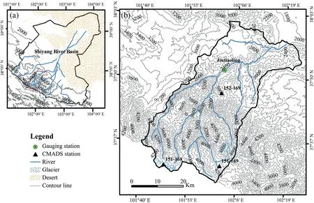
Fig.1. Overview map of the study area.
2.2.SWAT model
In this paper,SWAT (Soil and Water Assessment Tool) model was chosen to simulate the hydrological process in Xiying River.SWAT model is an open-source,physics-based and semi-distributed model,which is mainly used for water and soil management of the basin (Fig.2).The model spatially defines areas with the same combination of surface slope,land use,and soil type and divides them into Hydrological Response Units(HRUs).Hydrological simulation is carried out by using the water balance principle of each Hydrological Response Unit.The water balance formula is(Arnold et al.,1998):
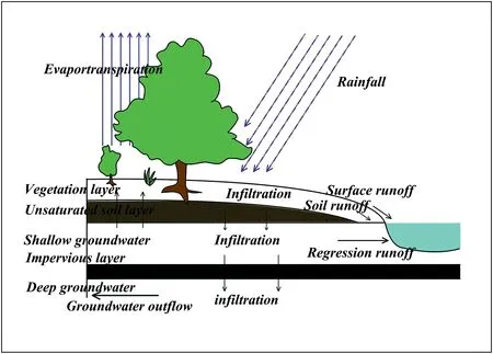
Fig.2. Schematic diagram of SWAT hydrological cycle.
where,SWtrepresents the final soil water content(mm);SWorepresents the initial soil water content (mm);t is time (day);Rdayrepresents the total precipitation on the ith day(mm);Qsurfrepresents the surface runoff on the ith day(mm);Earepresents the evaporation amount on the ith day(mm);Wseeprepresents the infiltration amount and lateral flow in the soil profile on the ith day (mm);Qgwrepresents the underground runoff on the ith day(mm).
Runoff simulation of the basin is mainly composed of four parts:surface runoff,evapotranspiration,soil water and groundwater.The calculation principles of each part are introduced respectively as follows.The Shiyang River Basin is a seasonal inland river basin in the northwest arid region.Its main water sources come from natural precipitation and ice-snow meltwater.The ice-snow meltwater has a great influence on simulation results of the model,so the melting process of ice and snow must be considered in the research process.
2.2.1.Model calibration,verification and uncertainty analysis
SWAT-CUP is a computer program that includes sensitivity analysis,calibration,verification,and uncertainty analysis for the SWAT model.Particle Swarm Optimization (PSO),SUFI-2 algorithm,Markov Chain Monte Carlo Method(MCMC),Parameter Solving Method(Para Sol)and Generalized Likelihood Uncertainty Estimation(GLUE)are embedded in the model.In this study,the SUFI-2 algorithm is chosen as the optimization method of parameter estimation.The algorithm considers the uncertainties of model structure,parameters,input data,and other factors,and visualizes the calibrated parameter range through the 95PPU(95 percent prediction uncertainty) diagram of simulated and observed values,so as to find the optimal combination of a series of parameters with the best simulation effect.LH-OAT is used for parameter sensitivity analysis to quantify the impact of parameters on runoff simulation.
2.2.2.Applicability evaluation of the model
In order to evaluate the accuracy of the model simulation results,it is necessary to compare simulated values with observed values for comparative analysis and verification.In this study,Percent bias(PBIAS),correlation coefficient (R2) and Nash-Sutcliffe efficiency coefficient(NSE)were selected to evaluate the model's applicability.
PBIAS=0,indicating that the simulated value is the same as the observed value;PBIAS〉0,indicating the overestimation bias;PBIAS〈0,indicating the underestimation bias.
The correlation coefficient R2is applied to further assess the data consistency of the observed and the simulated value.The closer R2is to 1,the closer the simulated value is to the observed value.R2〉0.6 is usually taken as the evaluation standard of the correlation.
Nash-Sutcliffe efficiency coefficient NSE is applied to describe the fitting accuracy between simulated value and observed value,which is a dimensionless statistical parameter with a value ranging from 0 to 1.The closer the value is to 1,the higher the dependability of the model simulation.Generally,the simulation result is more accurate and the simulation effect is better when NSE〉0.6.
Where,n is the number of stations,Qobsiis observed runoff data,Qsimiis simulated runoff data,are average values of observed and simulated runoff data,respectively.
2.3.M -K test
Mann-Kendall statistical test(Mann et al.,1945;Kendall et al.,1990)is a nonparametric test method recommended and applied by the World Meteorological Organization,which is suitable for trend test and mutation test of time series.It does not need tested samples to obey a definite probability distribution,which is not interfered by abnormal values.It has a wide detection range,less human interference and high quantification degree and can well reveal the mutation and trend changes of the whole time series,so it is suitable for hydrological,meteorological and other non-normal distribution data.
2.4.Comparative Method of the Slope Changing Ratio of Cumulative Quantity
Based on the Comparative Method of the Slope Changing Ratio of Cumulative Quantity,cumulative runoff is SRaand SRb(mm/a)before and after the turning point,cumulative precipitation is SPaand SPb(mm/a)before and after the turning point,cumulative evaporation is SEaand SEb(mm/a)before and after turning point.
where RSRrepresents the slope-changing ratio(%)of cumulative runoff,RSPrepresents the slope-changing ratio (%)of cumulative precipitation,RSErepresents the slope-changing ratio(%)of cumulative precipitation,a positive number represents slope increase,and the negative number represents slope decrease.
where CPrepresents the contribution rate of precipitation to runoff changes(%),CErepresents the contribution rate of evaporation to runoff changes(%),and CHrepresents the contribution rate of human activities to runoff changes(%).
2.5.CDO meteorological data downscaling method
The meteorological data of CanESM5 model is downscaled by bilinear interpolation,which is implemented in meteorological software CDO(climate data operators;https://code.mpimet.mpg.de/projects/cdo/wiki/Cdo).
2.6.Data sources
2.6.1.Input data for the SWAT model
In this paper,there are six kinds of input data: land use/cover type,soil type,DEM,slope,meteorological and hydrological data.Land use/cover type data came from the Center of Resources and Environmental Sciences and Data,Chinese Academy of Sciences (http://www.resdc.cn/).Soil type data came from the Harmonized World Soil Database version 1.1 (HWSD) constructed by the Food and Agriculture Organization of the United Nations (FAO) and the Vienna International Institute for Applied Systems Analysis(IIASA).30 m×30 m DEM data were from the United States Geological Survey (USGS) (https://glovis.usgs.gov/app?tour).Slope data was obtained by DEM data extraction.Meteorological data adopted daily data of The China Meteorological Assimilation Driving Datasets for the SWAT model Version 1.1(CMADS V1.1)(Meng et al.,2018),which covered the whole of east Asia (0°N-65°N,60°E-160°E) in space from 2008 to 2016.Daily runoff from the Jiutiaoling Station of the Shiyang River Basin Administration from 1986 to 2016 was selected as runoff data(Table 1).
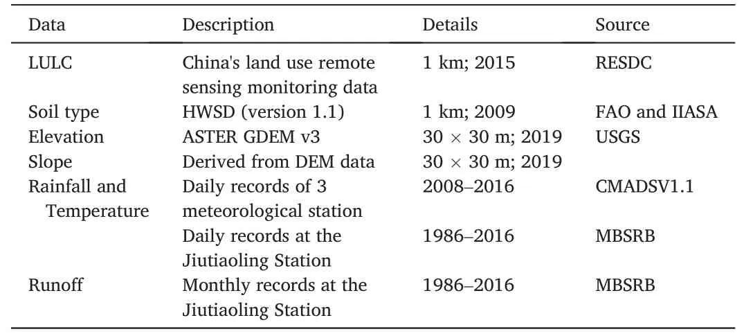
Table 1 Input data for the SWAT model in the upper reaches of the Shiyang River Basin.
2.6.2.Climate scenario simulation data
Simulations of daily near-surface temperatures(tas),minimum nearsurface temperatures (tasmin),maximum near-surface temperatures(tasmax),and precipitation (pr) were extracted from archived results from CanESM5 (from Canadian Centre for Climate Modelling and Analysis,Canada) participating in the CMIP6 project (https://esgf-node.llnl.gov/projects/cmip6/).
3.Results and analysis
3.1.SWAT simulation of runoff and calibration and verification of results
In this paper,runoff data observed at the Jiutiaoling Station of the Shiyang River Basin Administration were chosen,and model parameters were calibrated,with 2008-2013 and 2014-2016 as calibration period and verification period,respectively.Using SUFI-2 algorithm to calibrate and verify parameters,13 calibrated parameters were selected,the initial range of parameters was set,and evaluation indices were gradually met through repeated times,and optimal parameter values were obtained(Table 2).
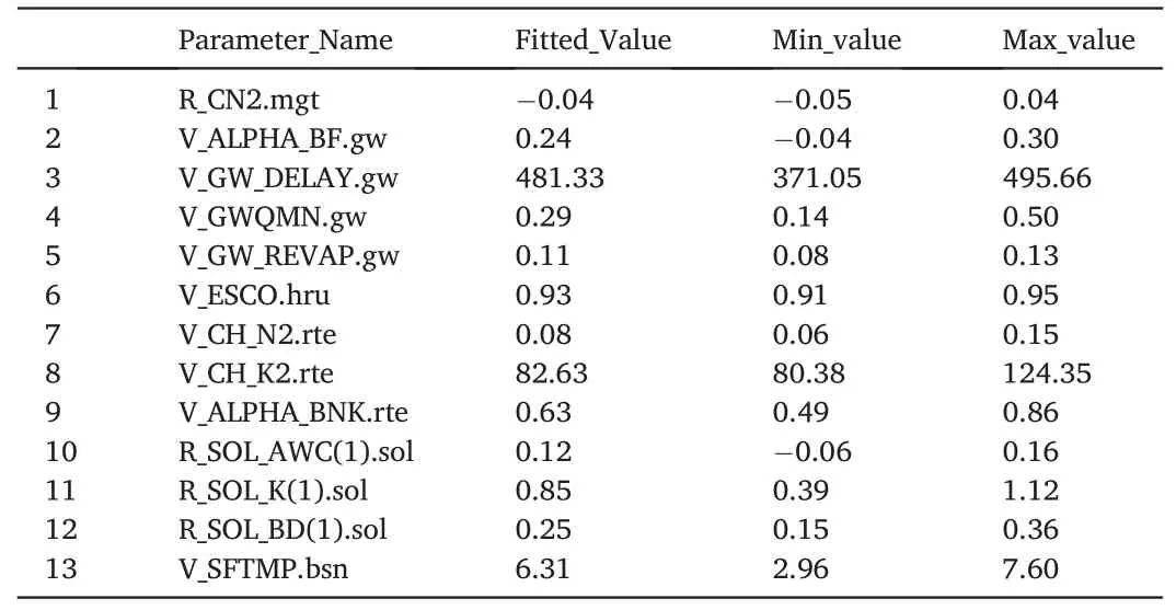
Table 2 Results of parameter sensitivity analysis.
P-factor and t-Stat were applied to calculate the sensitivity and sensitivity significance analysis results of model parameters (Abbaspour et al.,2007).T-Stat value gave the sensitivity degrees,and the greater the absolute value,the more sensitive it is.The significance of parameter sensitivity was analyzed by P-factor.The value range is 0-1,and the closer to 0,the more significant the sensitivity is.It is generally believed that this parameter is sensitive and important when P ≤0.05.However,when P ≥0.3,this parameter is insensitive(Cheng et al.,2017).For the Xiying River Basin,the most sensitive parameter was ALPHA_BF,followed by SOL_BD,SFTMP,SOL_K and ESCO (Fig.3).ALPHA_BF was the most sensitive parameter in this basin,which affected the process of converting precipitation and other recharge into the base flow,indicating that base flow was the main factor in the hydrological process of this basin.The sensitivity of soil moisture density (SOL_BD),soil saturated hydraulic conductivity coefficient (SOL_K),and soil evaporation compensation coefficient(ESCO)was also significant,which affect soil moisture,soil water conductivity,and soil water evaporation respectively,which indicated that soil water process also had a great influence on total runoff.SFTMP,a parameter related to snow melting,was also sensitive,indicating that runoff produced by melting snow and ice in the Xiying River Basin had a certain influence on total runoff,which is consistent with characteristics of glacier snow cover in the headwaters of the Xiying River.
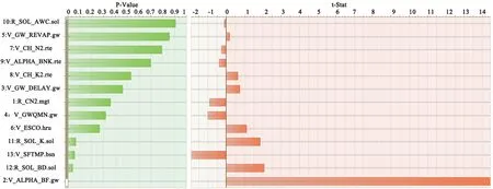
Fig.3. Sensitivity analysis of SWAT model parameters in the Xiying River Basin.
Comparing simulated and observed values of monthly runoff at the Jiutiaoling Hydrological Station under calibration period and verification period,the study results indicated that most of the periods were basically consistent,but simulation results also had overestimation or underestimation of the peak period of runoff in some years (Fig.4). Judging from calibration results,R2was 0.72 and NSE was 0.68 at the calibration period,R2was 0.76 and NSE was 0.72 at the verification period,all of which were greater than 0.6.The simulation degree was good,and observed runoff had a strong correlation with simulated runoff(Fig.5),which indicated that the model was suitable for the Xiying River Basin.
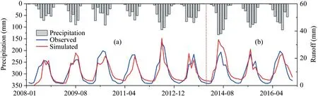
Fig.4. Monthly observed and simulated streamflow of hydrological stations in calibration period (a) and verification period (b).
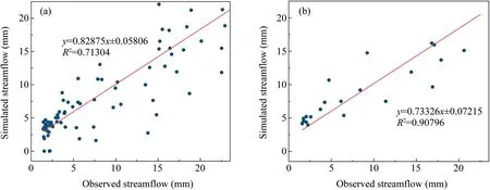
Fig.5. Observed and simulated streamflow in calibration period (a) and verification period (b).
3.2.Runoff changes in future climate scenarios
3.2.1.Selection of representative concentration pathway scenario of CMIP6
SSP1-2.6:The updated version of RCP2.6 in CMIP5.It belongs to the low radiative forcing scenario,and the radiative forcing was stable at about 2.6 W/m2in 2100.Under this scenario,the global average temperature will be significantly lower than 2°C compared with the multimodel ensemble average before the industrial revolution.
SSP2-4.5:The updated version of RCP4.5 in CMIP5.It belongs to the medium radiative forcing scenario,and the radiative forcing was stable at about 4.5 W/m2in 2100.The land use and aerosol path of SSP2 are not extreme,but only represent the combination of moderate social vulnerability and moderate radiation forcing,which is usually used as a reference for CMIP 6.
SSP5-8.5:The updated version of RCP8.5 in CMIP5.It belongs to the high radiative forcing scenario.The reason for choosing SSP5 is that SSP5 is the only way to achieve a high emission of 8.5 W/m2in 2100.
3.2.2.Prediction of precipitation and temperature in the Xiying River Basin under CMIP6 scenario
Based on the downscaling results of CanESM5 climate model in the sixth phase of the new Coupled Model Intercomparison Project(CMIP6),it is concluded that future precipitation and temperature will increase in the Xiying River Basin (Fig.6).Compared with the base period(2008-2016),in the SSP1-2.6 scenario,average temperature,maximum temperature and minimum temperature in recent years(2017-2050)will increase by 0.61,0.66 and 0.64°C,respectively.In the SSP2-4.5 scenario,average temperature,maximum temperature and minimum temperature in recent years (2017-2050) will increase by 1.09,1.21 and 1.00°C,respectively.In the SSP5-8.5 scenario,maximum temperature and minimum temperature in recent years (2017-2050) will increase by 1.74,1.61 and 1.98°C,respectively.In the Xiying River Basin,the temperature increases the most under high forcing scenario (SSP5-8.5) and the least under low emission scenario (SSP1-2.6).Annual precipitation shows an increasing trend in all scenarios.Compared with the base period(2008-2016),in scenarios of SSP1-2.6,SSP2-4.5 and SSP5-8.5,annual precipitation in recent years(2017-2050) will increase by 14.36,66.88 and 142.73 mm,respectively.The precipitation increases the most under high forcing scenario (SSP5-8.5) and the least under low emission scenario(SSP1-2.6)in the Xiying River Basin.
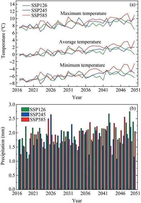
Fig.6. Changes of temperature (a) and precipitation (b) relative to the base period under CMIP6 scenario.
3.2.3.Response of runoff change in the Xiying River Basin under CMIP6 scenario
In order to further explore future runoff changes in the Xiying River Basin,meteorological data of the future time period (2017-2050)generated by downscaling were applied as input items to load the established SWAT model,so as to realize the loose coupling between the two models,and quantitatively explore the influence of climate change on the future runoff process according to coupling results.Under these three emission modes,compared with the base period,runoff increased.With the increase of time,runoff also increased correspondingly(Fig.7).The annual runoff was the largest in the high forcing scenario(SSP5-8.5)and the smallest under the low emission scenario(SSP1-2.6).The runoff of low,medium and high scenarios increased by 15,24 and 35 million m3,respectively.Runoff change in the SSP1-2.6 scenario was closest to the base period,followed by SSP2-4.5,and the runoff change was the largest under the SSP5-8.5 scenario.

Fig.7. Monthly runoff simulation under three emission scenarios from 2017 to 2050.
The distribution of runoff changes is not consistent within a year.There is less runoff in spring and winter.From April to May,runoff began to increase gradually,mainly because there is glacial snow in the source area of the Xiying River.When the temperature increases sharply in late spring,the melting amount of snow will increase,and runoff will increase accordingly.In summer (June-September),runoff increased significantly,which was basically consistent with the rainfall cycle.In this period,runoff was mainly recharged by rainfall,and the proportion of ice-snow meltwater recharge was relatively small compared with the rainfall recharge process(Fig.8).
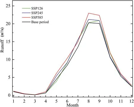
Fig.8. Comparison of monthly average runoff under three emission scenarios from 2017 to 2050 with the base period.
4.Discussions
4.1.Uncertainty analysis of runoff simulation
4.1.1.Influence of parameter calibration on the uncertainty of runoff simulation
In this study,the SUFI2 algorithm of SWAT-CUP software was applied for debugging and verifying parameters of daily scale runoff data in the Xiying River Basin.The observed and simulated daily runoff of the hydrological station in the Xiying River during the calibration period(2008-2013) and verification period (2014-2016) were in good agreement with each other,with the determination coefficients (R2) greater than 0.7 and the model efficiency coefficients (NSE) greater than 0.6.However,there were still some errors between simulation results and actual observation data.The positive value of PBIAS shows that the average trend simulated by the model overestimated observed runoff,and errors will have some influence on runoff simulation results in the future.
4.1.2.Uncertainty of runoff simulation caused by coupling of meteorological data and hydrological model
In the hydrological model simulation process,meteorological factors are an important factor that limits the performance of the model,and its uncertainty will influence the accuracy of hydrological cycle simulation results.The refined China Meteorological Assimilation Driving Dataset(CMADS) can better reflect the near-surface atmospheric conditions in China,and CMADS can well obtain the spatial distribution of precipitation,and daily temperature data is in the highest degree of coincidence with observation data of meteorological stations (Weng et al.,2020).Therefore,using CMADS data can reduce the uncertainty of hydrological model and provide data guarantee for areas lacking meteorological stations.CMADS+SWAT model was put forward in recent years.Meng et al.(2017) used the CMADS+SWAT model to achieve better simulation results in the Jingbo River Basin and the Heihe River Basin.The simulation results of the CMADS+SWAT model can well reflect the spatiotemporal distribution characteristics of runoff in arid areas.However,the time scale of the CMADS data set is relatively short(2008-2016),which leads to the relative shortening of the time for calibration and validation of model parameters,which inevitably affects sensitivity analysis,calibration,and validation results of parameters.
4.1.3.Uncertainty influence of climate model and scenario on runoff simulation
The global climate model data is the main data to explore the influence of future climate change on river runoff(Teng et al.,2012).Climate models have made great progress in the past three decades,and they have been widely used in future climate change and its impact and risk research (Huang et al.,2018;Gao et al.,2020).However,the structure,parameters,and spatial resolution of different global climate models still cause uncertainty in the simulation process (Dan et al.,2015).Previous studies show that the CanESM5 climate model had a good simulation effect in arid areas of China (Guo et al.,2021;Tang et al.,2021).Therefore,in this paper,we used CanESM5 climate model data to simulate the runoff change of the Xiying River,to avoid the uncertainty influence caused by the climate model as much as possible.For the selection of climate scenarios,CMIP6 proposed a new forecast scenario SSP-RCPs based on the latest man-made emission trends and different shared socio-economic paths (SSPs) (O'Neill et al.,2017;Zhou et al.,2019).Every Representative Concentration Pathway (RCP) represents the global radiative forcing level in the future,including RCP8.5,RCP7.0,RCP6.0,RCP4.5,RCP3.4,RCP2.6 and RCP1.9(O'Neill et al.,2017;Weng et al.,2020).In this paper,three scenarios were selected: SSP1-2.6,SSP2-4.5 and SSP5-8.5.SSP1-2.6 is a low-forcing scenario based on the sustainable development path,SSP2-4.5 is a medium-forcing scenario based on the intermediate path,SSP5-8.5 is a high-forcing scenario based on the traditional fossil fuel combustion path.The future climate change of the Xiying River Basin was studied from three forcing scenarios of low,medium and high,and the response of runoff of the Xiying River to climate change under different forcing scenarios was discussed.In addition,the CanESM5 climate model only has data of precipitation and temperature (maximum temperature,minimum temperature and average temperature).Therefore,in the process of future runoff simulation in the Xiying River Basin,this paper only inputs the daily data of maximum temperature,minimum temperature and precipitation generated by downscaling in the modes of SSP1-2.6,SSP2-4.5 and SSP5-8.5 into the SWAT model,and the rest remain unchanged to obtain the future runoff change process,which will also bring some uncertainty.
4.1.4.Uncertainty influence of meteorological data downscaling
At present,the Global Climate Model(GCM)is mainly used in climate change research,which can simulate climate characteristics on a global or continental scale.However,because of its original low resolution,the simulation effect on climate characteristics on the regional scale is poor,and the downscaling method is generally used to solve the problem (Li et al.,2015).In the process of downscaling research,the larger the downscaling span of the statistical model is,the greater the error between downscaling results and verification data is.Therefore,attention must be paid to the scale effect of data downscaling.According to the research needs,we downscale the CanESM5 model data to 0.01°using the bilinear interpolation method.
4.2.Quantitative analysis of the impact of climate change on runoff of the Xiying River
Climate change is a natural factor that influences river changes,among which precipitation,precipitation intensity,precipitation time and temperature changes will directly affect natural runoff.Human activities that cause the change of river inflow mainly include constructing water conservancy projects and construction of soil and water conservation measures(Li et al.,2019).Runoff changes occurring in the upper reaches areas where human activities have less influence are mainly due to climate change.
4.2.1.Stage division
Using the M-K test,observed data at the Jiutiaoling Station for the Xiying River from 1986 to 2016 was analyzed.The results show that runoff and precipitation changed sharply in 2003,and evaporation changed sharply in 2007.In order to keep the time consistency,the abrupt-change time is unified as 2003 of runoff change.It was mainly affected by climate change before 2003,which can be used as a base period.After 2003,the influence of human activities gradually appeared,and runoff changes were influenced by climate change and human activities.According to results of the M -K test,the evolution process of the Xiying River runoff can be divided into two periods:A(1986-2003)and B(2004-2016)(Fig.9).
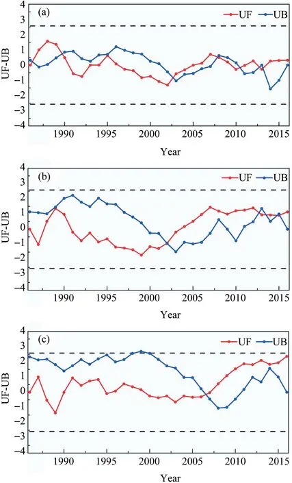
Fig.9. M -K statistical curves of (a) precipitation,(b) runoff and (c) evaporation at Jiutiaoling Station of Xiying River from 1986 to 2016.
4.2.2.Influence of climate and human activities on runoff change
Compared with A period(1986-2002),in B period(2003-2016),the annual linear relationship slope of cumulative runoff increased by 3,844.68 × 104m3/a,with an increase of 13.35%,resulting from the combined action of precipitation change,evaporation change and human activities.The annual linear relationship slope of cumulative precipitation increased by 4.65 mm/a,with an increase of 1.49%.The annual linear relationship slope of cumulative evaporation increased by 84.76 mm/a,with an increase of 10.44%(Table 3).Precipitation,evaporation and human activities contributed 10.98,78.19 and 10.83%,respectively,to the increase in runoff.Climate change and human activities contributed 89.17% and 10.83% to the increase in runoff.Climate change was the most important influencing factor of runoff change for the Xiying River(Table 3).
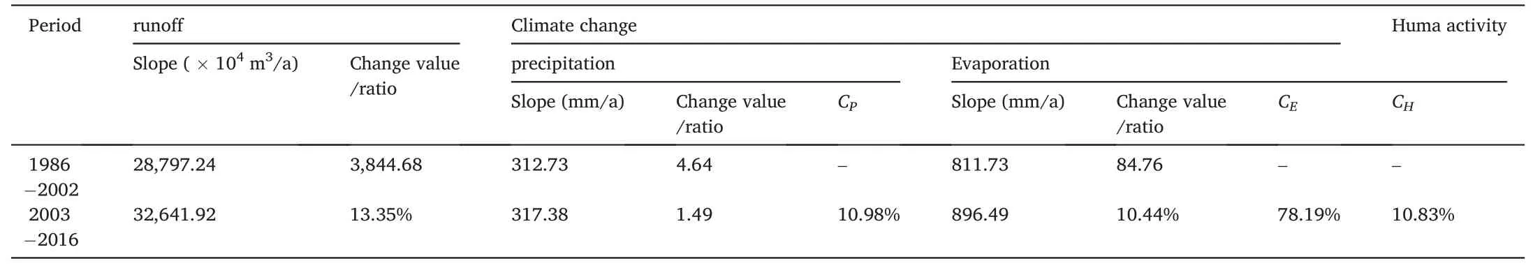
Table 3 Influence rate results of cumulant slope change rate method at Jiutiaoling Station in the Xiying River Basin.
5.Conclusion
In this paper,taking the Xiying River Basin as the study area,the SWAT model database was constructed by using CMADS dataset combined with basin-related spatial and attribute data to simulate runoff.The model was calibrated and verified by runoff observation data from the Jiutiaoling Hydrological Station.The evaluation indices R2and NSE were 0.72 and 0.68 during the calibration period(2008-2013),and 0.76 and 0.72 during the verification period (2014-2016),respectively.The simulation effect was good,which indicated that the SWAT model can accurately simulate runoff in high-altitude mountain areas and had certain applicability.
In order to further explore changes of future runoff in the Xiying River Basin,the CanESM5 climate model in CMIP6 was used for downscaling to obtain future climate scenario data.The prediction results show that average temperature will increase by 0.61,1.09 and 1.74°C,the maximum temperature will increase by 0.66,1.21 and 1.61°C,and the minimum temperature will increase by 0.64,1.00 and 1.98°C,respectively,under low,medium and high emission scenarios from 2017 to 2050.Annual average precipitation increased by 14.36,66.88 and 142.73 mm,respectively.The Xiying River Basin will show characteristics of warming and humidification in the future.The downscaled data of different climate scenarios were sorted and input into the corrected SWAT model to predict future runoff changes of the Xiying River Basin.The results indicated that annual runoff was the largest in the high forcing scenario (SSP5-8.5) and the smallest under the low emission scenario(SSP1-2.6).In the future,annual runoff will increase.The runoff of low,medium,and high scenarios increased by 15,24 and 35 million m3,respectively.Runoff distribution is inconsistent during the year,showing an increasing trend in summer and decreasing trend in spring and winter.
Acknowledgements
This research was financially supported by the National Natural Science Foundation of China (41867030,41971036),the key Natural Science Foundation of Gansu Province(23JRRA698),the key Research and Development Program of Gansu Province(22YF7NA122),the Oasis Scientific Research achievements Breakthrough Action Plan Project of Northwest normal University (NWNU-LZKX-202302),the cultivation Plan Project of the Major(key)Project of Northwest normal University.The authors thank their Northwest Normal University colleagues for their help in fieldwork,laboratory analysis,and data processing.Thanks Liu Jiatong for revising the language of the article,and thanks the editors and reviewers for their valuable suggestions on revising the article.
 Sciences in Cold and Arid Regions2023年3期
- Sciences in Cold and Arid Regions的其它文章
- Impacts of canopy structure on the sub-canopy solar radiation under a deciduous forest based on fisheye photographs
- Seepage influence of supra-permafrost groundwater on thermal field of embankment on Qinghai-Tibet Plateau,China
- An overview of the policies and models of integrated development for solar and wind power generation in China
- Editor-in-Chief Yuanming Lai
- Progress on research and mitigation of wind-blown sand risk in Dunhuang Singing Sand Mountain and Crescent Spring Scenic area,China
- Guidelines to Authors